
Wrexham is a city and the administrative centre of Wrexham County Borough in Wales. It is located between the Welsh mountains and the lower Dee Valley, near the border with Cheshire in England. Historically in the county of Denbighshire, and later the county of Clwyd in 1974, it has been the principal settlement of Wrexham County Borough since 1996.

Wrexham County Borough is a county borough, with city status, in the north-east of Wales. It borders the English ceremonial counties of Cheshire and Shropshire to the east and south-east respectively along the England–Wales border, Powys to the south-west, Denbighshire to the west and Flintshire to the north-west. The city of Wrexham is the administrative centre. The county borough is part of the preserved county of Clwyd.

Wrexham is a parliamentary constituency centred on the city of Wrexham in the preserved county of Clwyd, Wales in the United Kingdom. It was created in 1918, and is represented in the House of Commons of the UK Parliament since 2024 by Andrew Ranger of the Labour Party.

Wrexham is a constituency of the Senedd. It elects one Member of the Senedd by the first past the post method of election. Also, however, it is one of nine constituencies in the North Wales electoral region, which elects four additional members, in addition to nine constituency members, to produce a degree of proportional representation for the region as a whole.

Gwersyllt is an urban village and community in Wrexham County Borough, Wales.

Wrexham County Borough Council is the governing body for Wrexham County Borough, a principal area with city status in north Wales, covering Wrexham and the surrounding area.
Llay is a village and community in Wrexham County Borough, Wales.

Rhosddu is a suburb and community in Wrexham County Borough, Wales, covering the north-western parts of the city of Wrexham and comprises the wards of Grosvenor, Garden Village and Stansty.
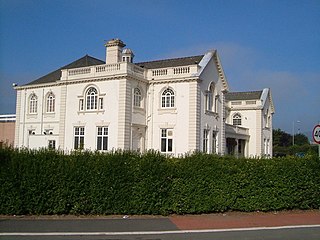
Bellevue Park, historically known as the Parciau, is an Edwardian park located in the city of Wrexham in northeastern Wales. Built to commemorate the jubilee year of the incorporation of the town, it is best known for the natural amphitheatre in its southeastern area, which holds regular concerts and live music performances during the summer months.
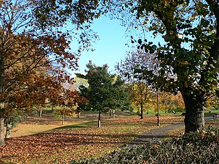
The city of Wrexham has two main city parks, these being Bellevue Park and Acton Park. On the outskirts of the city there is also open parkland on and surrounding the Erddig estate. There is also a city centre green and various smaller parks and open spaces.

Pandy is a village near Gwersyllt and Rhosrobin, in Wrexham, Wrexham County Borough, Wales. The main entrance to Gresford Colliery stood in the village. Gresford Colliery Social Club is in the village and alongside it a memorial to the Gresford Disaster, which killed 266 men on September 22, 1934.

Bradley is a village in Wrexham County Borough, Wales. Situated in the community of Gwersyllt, it is bounded by Alyn Waters Country Park to the north, the village of Gwersyllt to the west and south, and Bradley Hill, Wat's Dyke and the River Alyn to the east. The Bradley Built-up Area Sub-division (BUASD) is a subdivision of the Wrexham Built-up Area.

Offa is a community and electoral ward in Wrexham County Borough, Wales, covering most of the south-western portion of the city of Wrexham. It is bordered by the communities of; Rhosddu, and Caia Park to the north, Abenbury to the east, Esclusham, and Marchwiel to the south, and Broughton, Coedpoeth, and Gwersyllt to the west.
Sydallt is a village in Gwersyllt community, Wrexham County Borough, north Wales. It had a population of 422 as of the 2011 UK census.
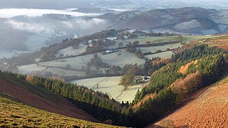
The Clwydian Range and Dee Valley is a designated Area of Outstanding Natural Beauty located in north-east Wales, covering the Clwydian Range, and the valley of the River Dee.

The 2022 Wrexham County Borough Council election took place on 5 May 2022 to elect 56 members to Wrexham County Borough Council, the principal council of Wrexham County Borough, Wales. On the same day, elections were held to the other 21 local authorities, and community councils in Wales as part of the 2022 Welsh local elections. The previous Wrexham County Borough all-council election took place in May 2017 and future elections will take place every five years, with the next scheduled for 2027.

Tŷ Mawr Country Park is a country park and farm park near Cefn Mawr in Wrexham County Borough, Wales. The country park lies between Cefn-bychan and Newbridge to the north, the River Dee to the south and west, and the Cefn Viaduct carrying the Shrewsbury–Chester line to the east.


