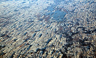
A drumlin, from the Irish word droimnín, first recorded in 1833, in the classical sense is an elongated hill in the shape of an inverted spoon or half-buried egg formed by glacial ice acting on underlying unconsolidated till or ground moraine. Assemblages of drumlins are referred to as fields or swarms; they can create a landscape which is often described as having a 'basket of eggs topography'.

Sedimentary rocks are types of rock that are formed by the accumulation or deposition of mineral or organic particles at Earth's surface, followed by cementation. Sedimentation is the collective name for processes that cause these particles to settle in place. The particles that form a sedimentary rock are called sediment, and may be composed of geological detritus (minerals) or biological detritus. The geological detritus originated from weathering and erosion of existing rocks, or from the solidification of molten lava blobs erupted by volcanoes. The geological detritus is transported to the place of deposition by water, wind, ice or mass movement, which are called agents of denudation. Biological detritus was formed by bodies and parts of dead aquatic organisms, as well as their fecal mass, suspended in water and slowly piling up on the floor of water bodies. Sedimentation may also occur as dissolved minerals precipitate from water solution.

Till or glacial till is unsorted glacial sediment.

Sediment is a naturally occurring material that is broken down by processes of weathering and erosion, and is subsequently transported by the action of wind, water, or ice or by the force of gravity acting on the particles. For example, sand and silt can be carried in suspension in river water and on reaching the sea bed deposited by sedimentation; if buried, they may eventually become sandstone and siltstone through lithification.
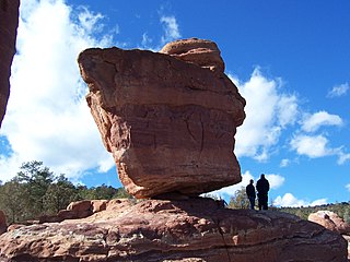
In geology, a boulder is a rock fragment with size greater than 25.6 cm (10.1 in) in diameter. Smaller pieces are called cobbles and pebbles. While a boulder may be small enough to move or roll manually, others are extremely massive. In common usage, a boulder is too large for a person to move. Smaller boulders are usually just called rocks or stones.

The geology of Great Britain is renowned for its diversity. As a result of its eventful geological history, Great Britain shows a rich variety of landscapes across the constituent countries of England, Wales and Scotland. Rocks of almost all geological ages are represented at outcrop, from the Archaean onwards.

Conglomerate is a sedimentary rock made up of rounded gravel-sized pieces of rock surrounded by finer-grained sediments. The larger fragments within conglomerate are called clasts, while the finer sediment surrounding the clasts is called the matrix. The clasts and matrix are typically cemented by calcium carbonate, iron oxide, silica, or hardened clay.

Glacial landforms are landforms created by the action of glaciers. Most of today's glacial landforms were created by the movement of large ice sheets during the Quaternary glaciations. Some areas, like Fennoscandia and the southern Andes, have extensive occurrences of glacial landforms; other areas, such as the Sahara, display rare and very old fossil glacial landforms.
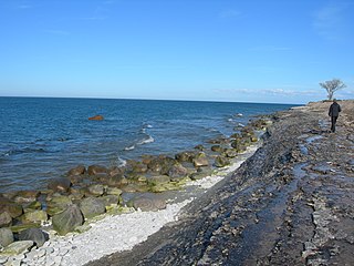
In geology, drift is a name for all sediment transported by a glacier and deposited directly by or from the ice, or by glacial meltwater. Drift is often subdivided into unstratified (unsorted) drift that forms moraines and stratified drift that accumulates as stratified and sorted sediments in the form of outwash plains, eskers, kames, varves, and so forth. The term drift clay is a synonym for boulder clay. Both are archaic terms for glacial tills with a fine-grained matrix.
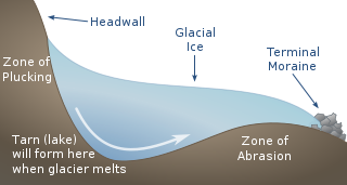
Plucking, also referred to as quarrying, is a glacial phenomenon that is responsible for the weathering and erosion of pieces of bedrock, especially large "joint blocks". This occurs in a type of glacier called a "valley glacier". As a glacier moves down a valley, friction causes the basal ice of the glacier to melt and infiltrate joints (cracks) in the bedrock. The freezing and thawing action of the ice enlarges, widens, or causes further cracks in the bedrock as it changes volume across the ice/water phase transition, gradually loosening the rock between the joints. This produces large chunks of rock called joint blocks. Eventually these joint blocks come loose and become trapped in the glacier.

Clastic rocks are composed of fragments, or clasts, of pre-existing minerals and rock. A clast is a fragment of geological detritus, chunks, and smaller grains of rock broken off other rocks by physical weathering. Geologists use the term clastic to refer to sedimentary rocks and particles in sediment transport, whether in suspension or as bed load, and in sediment deposits.
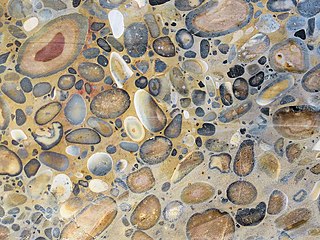
Puddingstone, also known as either pudding stone or plum-pudding stone, is a popular name applied to a type of conglomerate that consists of distinctly rounded pebbles whose colours contrast sharply with the colour of the finer-grained, often sandy, matrix or cement surrounding them. The rounded pebbles and the sharp contrast in colour gives this type of conglomerate the appearance of a raisin or Christmas pudding. There are different types of puddingstone, with different composition, origin, and geographical distribution. Examples of different types of puddingstones include the Hertfordshire, Schunemunk, Roxbury, and St. Joseph Island puddingstones.

The geology of England is mainly sedimentary. The youngest rocks are in the south east around London, progressing in age in a north westerly direction. The Tees–Exe line marks the division between younger, softer and low-lying rocks in the south east and the generally older and harder rocks of the north and west which give rise to higher relief in those regions. The geology of England is recognisable in the landscape of its counties, the building materials of its towns and its regional extractive industries.
Fluvioglacial landforms or glaciofluvial landforms are those that result from the associated erosion and deposition of sediments caused by glacial meltwater. Glaciers contain suspended sediment loads, much of which is initially picked up from the underlying landmass. Landforms are shaped by glacial erosion through processes such as glacial quarrying, abrasion, and meltwater. Glacial meltwater contributes to the erosion of bedrock through both mechanical and chemical processes. Fluvio-glacial processes can occur on the surface and within the glacier. The deposits that happen within the glacier are revealed after the entire glacier melts or partially retreats. Fluvio-glacial landforms and erosional surfaces include: outwash plains, kames, kame terraces, kettle holes, eskers, varves, and proglacial lakes.
This glossary of geology is a list of definitions of terms and concepts relevant to geology, its sub-disciplines, and related fields. For other terms related to the Earth sciences, see Glossary of geography terms (disambiguation).

Cape Town lies at the south-western corner of the continent of Africa. It is bounded to the south and west by the Atlantic Ocean, and to the north and east by various other municipalities in the Western Cape province of South Africa.

A cobble is a clast of rock defined on the Udden–Wentworth scale as having a particle size of 64–256 millimeters (2.5–10.1 in), larger than a pebble and smaller than a boulder. Other scales define a cobble's size differently. A rock made predominantly of cobbles is termed a conglomerate. Cobblestone is a building material based on cobbles.
The geology of Maine is part of the broader geology of New England and eastern North America.

The geology of North Dakota includes thick sequences oil and coal bearing sedimentary rocks formed in shallow seas in the Paleozoic and Mesozoic, as well as terrestrial deposits from the Cenozoic on top of ancient Precambrian crystalline basement rocks. The state has extensive oil and gas, sand and gravel, coal, groundwater and other natural resources.
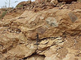
The Edaga Arbi Glacials are a Palaeozoic geological formation in Tigray and in Eritrea. The matrix is composed of grey, black and purple clays, that contains rock fragments up to 6 metres across. Pollen dating yields a Late Carboniferous to Early Permian age.


