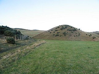
A drumlin, from the Irish word droimnín, first recorded in 1833, in the classical sense is an elongated hill in the shape of an inverted spoon or half-buried egg formed by glacial ice acting on underlying unconsolidated till or ground moraine. Assemblages of drumlins are referred to as fields or swarms; they can create a landscape which is often described as having a 'basket of eggs topography'.

A moraine is any accumulation of unconsolidated debris, sometimes referred to as glacial till, that occurs in both currently and formerly glaciated regions, and that has been previously carried along by a glacier or ice sheet. It may consist of partly rounded particles ranging in size from boulders down to gravel and sand, in a groundmass of finely-divided clayey material sometimes called glacial flour. Lateral moraines are those formed at the side of the ice flow, and terminal moraines are those formed at the foot, marking the maximum advance of the glacier. Other types of moraine include ground moraines and medial moraines.

Till or glacial till is unsorted glacial sediment.

A loess is a clastic, predominantly silt-sized sediment that is formed by the accumulation of wind-blown dust. Ten percent of Earth's land area is covered by loesses or similar deposits.
A kame, or knob, is a glacial landform, an irregularly shaped hill or mound composed of sand, gravel and till that accumulates in a depression on a retreating glacier, and is then deposited on the land surface with further melting of the glacier. Kames are often associated with kettles, and this is referred to as kame and kettle or knob and kettle topography. The word kame is a variant of comb, which has the meaning "crest" among others. The geological term was introduced by Thomas Jamieson in 1874.

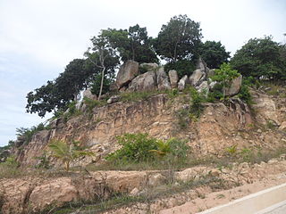
A glacial erratic is a glacially deposited rock differing from the type of rock native to the area in which it rests. Erratics, which take their name from the Latin word errare, are carried by glacial ice, often over distances of hundreds of kilometres. Erratics can range in size from pebbles to large boulders such as Big Rock in Alberta.

Bolshoy Lyakhovsky Island, or Great Lyakhovsky, is the largest of the Lyakhovsky Islands belonging to the New Siberian Islands archipelago between the Laptev Sea and the East Siberian Sea in northern Russia. It has an area of 5,156.6 km2 (1,991.0 sq mi), and a maximum altitude of 311 m (1,020 ft).
Colluvium is a general name for loose, unconsolidated sediments that have been deposited at the base of hillslopes by either rainwash, sheetwash, slow continuous downslope creep, or a variable combination of these processes. Colluvium is typically composed of a heterogeneous range of rock types and sediments ranging from silt to rock fragments of various sizes. This term is also used to specifically refer to sediment deposited at the base of a hillslope by unconcentrated surface runoff or sheet erosion.

Glacial landforms are landforms created by the action of glaciers. Most of today's glacial landforms were created by the movement of large ice sheets during the Quaternary glaciations. Some areas, like Fennoscandia and the southern Andes, have extensive occurrences of glacial landforms; other areas, such as the Sahara, display rare and very old fossil glacial landforms.
Parent material is the underlying geological material in which soil horizons form. Soils typically inherit a great deal of structure and minerals from their parent material, and, as such, are often classified based upon their contents of consolidated or unconsolidated mineral material that has undergone some degree of physical or chemical weathering and the mode by which the materials were most recently transported.
Diamicton is a terrigenous sediment that is unsorted to poorly sorted and contains particles ranging in size from clay to boulders, suspended in an unconsolidated matrix of mud or sand. Today, the word has strong connotations to glaciation but can be used in a variety of geological settings.
Boulder clay is an unsorted agglomeration of clastic sediment that is unstratified and structureless and contains gravel of various sizes, shapes, and compositions distributed at random in a fine-grained matrix. The fine-grained matrix consists of stiff, hard, pulverized clay or rock flour. Boulder clay is also known as drift clay; till; and unstratified drift.
Diluvium is an archaic term applied during the 1800s to widespread surficial deposits of sediments that could not be explained by the historic action of rivers and seas. Diluvium was initially argued to have been deposited by the action of extraordinary floods of vast extent, specifically the Noachian Flood.
Superficial deposits refer to geological deposits typically of Quaternary age for the Earth. These geologically recent unconsolidated sediments may include stream channel and floodplain deposits, beach sands, talus gravels and glacial drift and moraine. All pre-Quaternary deposits are referred to as bedrock.

The glacial history of Minnesota is most defined since the onset of the last glacial period, which ended some 10,000 years ago. Within the last million years, most of the Midwestern United States and much of Canada were covered at one time or another with an ice sheet. This continental glacier had a profound effect on the surface features of the area over which it moved. Vast quantities of rock and soil were scraped from the glacial centers to its margins by slowly moving ice and redeposited as drift or till. Much of this drift was dumped into old preglacial river valleys, while some of it was heaped into belts of hills at the margin of the glacier. The chief result of glaciation has been the modification of the preglacial topography by the deposition of drift over the countryside. However, continental glaciers possess great power of erosion and may actually modify the preglacial land surface by scouring and abrading rather than by the deposition of the drift.
Fluvioglacial landforms or glaciofluvial landforms are those that result from the associated erosion and deposition of sediments caused by glacial meltwater. Glaciers contain suspended sediment loads, much of which is initially picked up from the underlying landmass. Landforms are shaped by glacial erosion through processes such as glacial quarrying, abrasion, and meltwater. Glacial meltwater contributes to the erosion of bedrock through both mechanical and chemical processes. Fluvio-glacial processes can occur on the surface and within the glacier. The deposits that happen within the glacier are revealed after the entire glacier melts or partially retreats. Fluvio-glacial landforms and erosional surfaces include: outwash plains, kames, kame terraces, kettle holes, eskers, varves, and proglacial lakes.
The Sangamonian Stage is the term used in North America to designate the Last Interglacial and depending on definition, part of the early Last Glacial Period, corresponding to Marine Isotope Stage 5. While often historically considered equivalent in scope to MIS 5, it is now often used in a more narrow sense to refer to the Last Interglacial only. It preceded the Wisconsinan (Wisconsin) Stage and followed the Illinoian Stage in North America.

The geology of Massachusetts includes numerous units of volcanic, intrusive igneous, metamorphic and sedimentary rocks formed within the last 1.2 billion years. The oldest formations are gneiss rocks in the Berkshires, which were metamorphosed from older rocks during the Proterozoic Grenville orogeny as the proto-North American continent Laurentia collided against proto-South America. Throughout the Paleozoic, overlapping the rapid diversification of multi-cellular life, a series of six island arcs collided with the Laurentian continental margin. Also termed continental terranes, these sections of continental rock typically formed offshore or onshore of the proto-African continent Gondwana and in many cases had experienced volcanic events and faulting before joining the Laurentian continent. These sequential collisions metamorphosed new rocks from sediments, created uplands and faults and resulted in widespread volcanic activity. Simultaneously, the collisions raised the Appalachian Mountains to the height of the current day Himalayas.
The Finchley Gap is a location centred on Church End, Finchley, in north London, England. As a topographical feature approximately eight kilometres wide, lying between higher ground to the north-west and to the south-east, it has probably existed for the last one million years or more.

The geology of Rhode Island is based on nearly one billion year old igneous crystalline basement rocks formed as part of the microcontinent Avalonia that collided with the supercontinent Gondwana. The region experienced substantial folding associated with its landlocked position during the Alleghanian orogeny mountain building event. The region accumulated sedimentary rocks, including small deposits of coal. The region was covered with thick Atlantic Coastal Plain sediments, with the erosion of the Appalachians and the creation of the Atlantic Ocean throughout the past 200 million years. These surficial sediments and soils were substantially reworked by the Pleistocene glaciations. The state's geology is part of the broader geology of New England.
