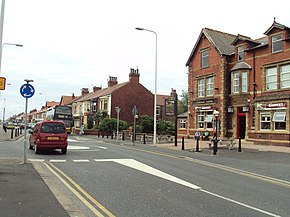
The road runs a total distance of approximately 9.5 miles (15.3km), largely on residential and commercial streets. It begins close to the Oxford Square junction in Marton, in the south-eastern part of Blackpool (53°48′15″N3°01′29″W / 53.8043°N 3.0246°W / 53.8043; -3.0246 (A587 road (southern end))), as a turning off the A583, Preston New Road. It continues north, as South Park Drive and later East Park Drive, past Stanley Park and Blackpool Victoria Hospital for about 1.5 miles (2.4km), until the Four Lane Ends roundabout. At this point, as St Walburga's Road, it continues north, and later becomes dual carriageway for 0.7 miles (1.1km) which forms a border between the suburbs of Layton and Grange Park. After the Plymouth Road roundabout, it crosses the railway close to Layton station, and continues north as Bispham Road for a further 1.4 miles (2.3km), passing through the Warbreck area before reaching Bispham roundabout.
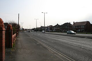
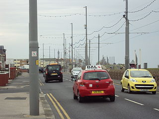
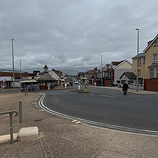
From Bispham it then continues north, as Devonshire Road and later Fleetwood Road, for a further 1.3 miles (2.1km) through the north Blackpool suburbs of Norbreck and Little Bispham before it is joined at Anchorsholme by the A584 Queen's Promenade. The A587 then heads north for 0.5 miles (0.80km) as a dual carriageway, named Fleetwood Road and Kelso Avenue for north and southbound traffic respectively, with the tram tracks dividing the road until entering the town of Cleveleys and the Wyre District. Past Victoria Road in Cleveleys, as a single-lane road now known as Rossall Road, it continues north for a further 1.5 miles (2.4km), past Rossall School in a short 40-mph section, and into Fleetwood, where it becomes Broadway. The road crosses West View roundabout, and turns right down Poulton Road, eventually terminating at the Ash Street roundabout, near Affinity Lancashire(53°55′09″N3°00′51″W / 53.9193°N 3.0142°W / 53.9193; -3.0142 (A587 road (northern end))), where it joins to the A585.
The M180 is a 25.5-mile (41 km) motorway in eastern England, starting at junction 5 on the M18 motorway in Hatfield, within the Metropolitan Borough of Doncaster, South Yorkshire, and terminating at Barnetby, Lincolnshire, some 10 miles (16 km) from the port of Immingham and 14 miles (23 km) from the port of Grimsby. The A180 road continues to the east for Grimsby, Cleethorpes and Immingham. Scunthorpe, Lincoln, Hull, Brigg, Bawtry and the Isle of Axholme can be accessed using the motorway. Humberside Airport, the now-closed Doncaster Sheffield Airport, and the Killingholme, Humber and Lindsey oil refineries are close to the motorway. The road forms part of the unsigned Euroroute E22 and is the main route along the south bank of the Humber Estuary.
Cleveleys is a town on the Fylde Coast of Lancashire, England, about 4 miles (6 km) north of Blackpool and 2 miles (3 km) south of Fleetwood. It is part of the Borough of Wyre. With its neighbouring settlement of Thornton, Cleveleys was part of the former urban district of Thornton-Cleveleys and is part of the Blackpool Urban Area. In 2011 the Cleveleys Built-up area sub division had a population of 10,754.
The M181 is a motorway that links the town of Scunthorpe, England, to the M180 motorway. A spur of the M180, the road is virtually straight through its entire 2-mile (3.2 km) length. It was opened in December 1978, at the same time as the section of M180 from junction 3 (A15) to the east side of the River Trent.
The Blackpool Tramway runs from Blackpool to Fleetwood on The Fylde in Lancashire, England. The line dates back to 1885 and is one of the oldest electric tramways in the world. It is operated by Blackpool Transport Services (BTS) and runs for 18 km. It carried 4.9 million passengers in 2022/23.
Blackpool North and Fleetwood is a parliamentary constituency represented in the House of Commons of the Parliament of the United Kingdom. It was recreated in 2024 following the 2023 Periodic Review of Westminster constituencies and elects one member of parliament (MP) by the first past the post system of election. Its boundaries are similar to those of the 1997–2010 constituency and largely replace Blackpool North and Cleveleys.
The A689 is a road in northern England that runs east from the A595, 3.1 miles (5.0 km) to the west of Carlisle in Cumbria, to Hartlepool in County Durham.
Blackpool North and Cleveleys was a constituency represented in the House of Commons of the UK Parliament since 2010 by Paul Maynard, a Conservative.
Bispham is a village on the Fylde coast in the Borough of Blackpool in Lancashire, England.
Rossall is a settlement in Lancashire, England and a suburb of the market town of Fleetwood. It is situated on a coastal plain called The Fylde. Blackpool Tramway runs through Rossall, with two stations: Rossall School on Broadway and Rossall Square on South strand.
The A591 is a major road in Cumbria, which lies almost entirely within the Lake District national park. A 2009 poll by satellite navigation firm Garmin named the stretch of the road between Windermere and Keswick as the most popular road in Britain. The 29.8 mile stretch between Kendal and Keswick was also named the UK's best driving road, according to a specially devised driving ratio formulated by car rental firm Avis.
The A1068 is a road in northern England that runs from Seaton Burn in North Tyneside to Alnwick in Northumberland. The section between Ellington and Alnmouth is signposted as part of the Northumberland Coastal Route.
The A583 is a primary road from Preston to Blackpool in England, via Kirkham. It runs a distance of 17 miles (27.4 km), and was previously the main route into Blackpool until the construction of the M55 motorway.
The A405 is a 4.8 miles dual carriageway road in Hertfordshire, England, from the A41 at Leavesden Green, near Watford, to the A414 at Park Street Roundabout near St Albans.
The A585 is a primary road in England which runs from Kirkham to Fleetwood in Lancashire.
The A158 road is a major route that heads from Lincoln in the west to Skegness on the east coast. The road is located entirely in the county of Lincolnshire and is single carriageway for almost its entirety. The road is approximately 40 miles (64 km) long. The road gets quite congested with holiday traffic during the summer.
The A588 is a road in western Lancashire, England, which runs for around 20 miles (32 km), from Poulton-le-Fylde northeastwards to Lancaster. It is the main route serving the Over Wyre areas of the Fylde.
The A584 is a road in Lancashire, England, that runs from Clifton, near Preston, to Little Bispham, in the north of Blackpool.
The A586 is a road in Lancashire, England, which runs from Garstang to Blackpool.
Blackpool and the Fylde coast have become a ship graveyard for a number of vessels over the years. Most of the shipwrecks occurred at or near Blackpool, whilst a few happened a little further afield but have strong connections with the Blackpool area. For this article, Blackpool means the stretch of coast from Fleetwood to Lytham St Annes.
Victoria Road is a major thoroughfare in Thornton-Cleveleys, Lancashire, England. Originally known as Ramper Road, it runs for about 2 miles (3.2 km) from Station Road in Thornton, in the east, to South Promenade in Cleveleys, in the west. Its addresses are denoted as "Victoria Road East" or "Victoria Road East", the split occurring at the Amounderness Way roundabout carrying traffic of the A585 between Poulton-le-Fylde and Fleetwood. The road picks up the B5412 designation from Station Road until The Crescent and Brighton Avenue in Cleveleys.
This page is based on this Wikipedia article Text is available under the CC BY-SA 4.0 license; additional terms may apply. Images, videos and audio are available under their respective licenses.