History
The Domesday Book (1086) entry for Woore (“Waure”) shows that the manor was held not from Earl Roger of Shrewsbury, but as a tenant-in-chief from the King, by William Malbedeng (William Malbank), and contained a large hall within the moated site at what is now Syllenhurst Farm. Lying in the Hundred of Hodnet, there were 5 households in Woore itself, the value of which to the Lord was assessed for tax at 5 shillings, with woodland for 60 pigs. William Malbank also held land at Dorrington (2 households with land for 3 ploughlands, woodland for 100 pigs, valued at 4 shillings), Gravenhunger (2 households with land for 4 ploughlands, valued at 6 shillings) and Onneley (no households, valued at less than 2 shillings). He had succeeded a pre-Conquest Saxon Lord, Edric. In later medieval times the most notable family of Woore was the de Bulkeleys.
Modern day
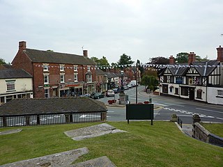
The village today is mostly residential with a number of small shops, centred on the Post Office and general stores on the village square. Two public houses service the village, along with one modern red brick primary school and two churches, the smaller of which is a Methodist church, popularly known as "the Chapel on the corner", and the larger of which is St. Leonard's Church of England parish church.
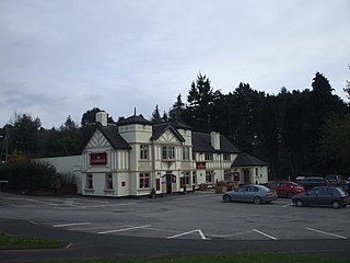
Woore Cricket Club play at the Falcon Field in the village, which slopes downwards dramatically from the Pavilion and Falcon Inn sides. [4]
Bridgemere Garden World is to the north of Woore, just over the border in Cheshire.
Audlem is a village and civil parish located in Cheshire, North West England. In 2021, it had a population of 1,832.

Newcastle-under-Lyme is a market town and the administrative centre of the Borough of Newcastle-under-Lyme in Staffordshire, England. It is adjacent to the city of Stoke-on-Trent. In 2021 the population was 75,082.

Market Drayton is a market town and civil parish on the banks of the River Tern in Shropshire, England. It is close to the Cheshire and Staffordshire borders. It is located between the towns of Whitchurch, Wem, Nantwich, Newcastle-under-Lyme, Newport and the city of Stoke on Trent. The town is on the Shropshire Union Canal and bypassed by the A53 road.

Mucklestone is a village and former civil parish, now in the parish of Loggerheads, in the Newcastle-under-Lyme district, in the county of Staffordshire, England. It is about nine miles (14 km) northwest of Eccleshall, and four and a half miles northeast of Market Drayton in Shropshire. In 1961 the parish had a population of 409. On 1 April 1984 the parish was abolished to form Loggerheads.

The Borough of Newcastle-under-Lyme is a local government district with borough status in Staffordshire, England.
Loggerheads is a village and civil parish in north-west Staffordshire, England, on the A53 between Market Drayton and Newcastle-under-Lyme. The village is close to the border with Shropshire and Cheshire. It has a Telford postcode and a Shropshire address, but is governed by the Newcastle-under-Lyme Borough Council in Staffordshire.

Keele is a village and civil parish in the Borough of Newcastle-under-Lyme in Staffordshire, England. It is approximately 3 miles (4.8 km) west of Newcastle-under-Lyme, and is close to the village of Silverdale. Keele lies on the A53 road from Newcastle to Market Drayton and Shrewsbury. The village is the location of Keele University and Keele Services, a motorway service area on the M6.

Dorrington Lane is a hamlet near the village of Woore in northeast Shropshire, England. There are around 12 former council houses and two larger houses called Norley and Oakley cottage. There is a large mansion house called Dorrington Old Hall which is about 700 years old. The hamlet contains several farms, including one of the biggest stud farms outside Newmarket. The main nearby towns are Market Drayton, Newcastle-under-Lyme, Nantwich and Crewe. The nearest city is Stoke on Trent.

Madeley is a village and ward in the Borough of Newcastle-under-Lyme, North Staffordshire, England. It is split into three parts: Madeley, Middle Madeley, and Little Madeley. Madeley Heath is also considered by many to be part of Madeley. In the 2001 census, the population was recorded as 4,386, decreasing to 4,222 at the 2011 Census.
Betley is a village and civil parish in the borough of Newcastle-under-Lyme in Staffordshire, England, about halfway between the town of Newcastle-under-Lyme and Nantwich. Betley forms a continual linear settlement with Wrinehill.

The A525 is a major route from Rhyl in Wales to Newcastle-under-Lyme in England. The route passes near Denbigh, through Ruthin, through Wrexham and near Whitchurch.
Baldwin's Gate is a village in the Borough of Newcastle-under-Lyme in Staffordshire. The population details for the 2011 census can be found under Whitmore. There is a pub in the centre of the village called The Sheet Anchor, along with a Post Office & General Store, a primary school and another small shop with a petrol station. There is also a Methodist church and just outside the village is Slater's Country Inn.

Bridgemere is a village and former civil parish, now in the parish of Doddington and District, in the unitary authority area of Cheshire East and the ceremonial county of Cheshire, England. It is around 7 miles (11 km) south east of Nantwich and 12 miles (19 km) west of Stoke-on-Trent. The southern boundary of the parish is on the border with Shropshire. The civil parish also included the small settlements of Admiral's Gorse, Parrah Green, Prince Hill, Seven Stars and Wheel Green. In 2011 the parish had a population of 148. Nearby towns include Crewe in Cheshire, Market Drayton and Whitchurch in Shropshire, and villages include Blakenhall, Buerton and Hankelow in Cheshire, Madeley, Staffordshire and Woore, Shropshire.

Checkley cum Wrinehill is a former civil parish, now in the parish of Doddington and District, in the unitary authority area of Cheshire East and the ceremonial county of Cheshire, England, which lies adjacent to the boundaries with Shropshire and Staffordshire. The hamlet of Checkley lies to the south east of Crewe and to the west of Newcastle-under-Lyme. The parish is largely rural but also includes the small settlements of Bunkers Hill and Randilow. Wrinehill was formerly included in the parish, becoming part of Staffordshire in 1965. Nearby villages include Blakenhall, Bridgemere, Madeley and Woore. In 2001 the parish had a population of 129.
The Stoke to Market Drayton Line was a railway line that ran through Staffordshire and Shropshire that was built by the North Staffordshire Railway.

The Nantwich and Market Drayton Railway was a standard gauge railway line which began as a single line branch in the early 1860s and rapidly became part of the Great Western Railway's (GWR) double track Wellington to Nantwich Railway, which had through trains to Crewe. It carried through freight and local passenger traffic until its closure in the 1960s. Market Drayton was renowned for the manufacture of gingerbread, hence the line acquired the nickname the "Gingerbread Line".

Pipe Gate was a railway station on the North Staffordshire Railway's Stoke to Market Drayton Line.

Market Drayton railway station served the town of Market Drayton in Shropshire, England, between 1863 and 1963. It was at the junction where three railway lines met: two of them, forming the Great Western Railway route between Wellington (Shropshire) and Crewe, were met by a line from Stoke-on-Trent on the North Staffordshire Railway.
The Wellington to Nantwich Railway was a railway line that ran from the Wellington to Nantwich via Market Drayton. The line closed in 1967 to all traffic and the track was dismantled in 1970. The line also connected to the former Stoke-Market Drayton Line at Market Drayton which was a junction station for the line until the closure to Madeley Chord in 1956.

