Telford and Wrekin Telford | |
|---|---|
| |
 Flag | |
| Nickname: Wrekin | |
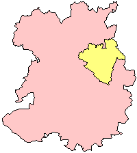
 Shown within Shropshire | |
| Coordinates: 52°40′52″N2°26′19″W / 52.68111°N 2.43861°W | |
| Country | United Kingdom |
| Region | West Midlands |
| County | Shropshire |
| Admin HQ | Telford |
| Established | 1998 |
| Government | |
| Area | |
• Total | 290.31 km2 (112.09 sq mi) |
| Population | |
• Total | 185,600 |
| • Density | 639.3/km2 (1,656/sq mi) |
| Ethnicity (2021) | |
| • Ethnic groups | |
| Religion (2021) | |
| • Religion | List
|
| Time zone | GMT |
| ISO 3166 code | GB-TFW |
| Website | telford |


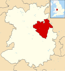
Telford and Wrekin is a borough and unitary authority in Shropshire, England. In 1974, a non-metropolitan district of Shropshire was created called the Wrekin, named after a prominent hill to the west of Telford. In 1998, the district became a unitary authority and was renamed "Telford and Wrekin", which remains part of the Shropshire ceremonial county and shares institutions such as the Fire and Rescue Service and Community Health with the rest the county.
Contents
- History
- Wards
- Election history
- Governance
- Policing
- Towns, villages and other settlements
- Demography
- Economy
- Freedom of the Borough
- People
- Military units
- Organisations
- See also
- References
- External links
The borough's major settlement is Telford, which was designated a new town in the 1960s and incorporated the towns of Dawley, Madeley, Oakengates, and Wellington. After the Telford conurbation, which includes the aforementioned towns, the next-largest settlement is Newport which is located in the northeast of the borough and is not part of the original new town of Telford. The borough borders Staffordshire, but is surrounded by the unitary district of Shropshire which covers the area previously administered by Shropshire County Council.