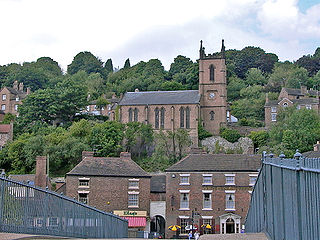
Ironbridge is a riverside village in the borough of Telford and Wrekin in Shropshire, England. Located on the bank of the River Severn, at the heart of the Ironbridge Gorge, it lies in the civil parish of The Gorge. Ironbridge developed beside, and takes its name from, The Iron Bridge, a 100-foot (30 m) cast iron bridge that was built in 1779.

The Ironbridge Gorge is a deep gorge, containing the River Severn in Shropshire, England. It was first formed by a glacial overflow from the long drained away Lake Lapworth, at the end of the last ice age. The deep exposure of the rocks cut through by the gorge exposed commercial deposits of coal, iron ore, limestone and fireclay, which enabled the rapid economic development of the area during the early Industrial Revolution.

Coalbrookdale is a town in the Ironbridge Gorge and the Telford and Wrekin borough of Shropshire, England, containing a settlement of great significance in the history of iron ore smelting. It lies within the civil parish called the Gorge.
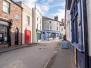
Blists Hill Victorian Town is an open-air museum built on a former industrial complex located in Madeley, Telford and Wrekin, Shropshire, England. The museum attempts to recreate the sights, sounds and smells of a Victorian Shropshire town in the late 19th and early 20th centuries. It is one of ten museums operated by the Ironbridge Gorge Museum Trust.

The Hay Inclined Plane is a canal inclined plane in the Ironbridge Gorge in Shropshire, with a height of 207 feet (63 m). It was located at the end of the Shropshire Canal, part of a network of canals that linked the industrial region of east Shropshire with the River Severn. The inclined plane was in operation from 1793 to 1894. It can be visited as part of the Blists Hill Victorian Town and is also a waypoint on the South Telford Heritage Trail.
Broseley is a market town in Shropshire, England, with a population of 4,929 at the 2011 Census and an estimate of 5,022 in 2019. The River Severn flows to its north and east. The first iron bridge in the world was built in 1779 across the Severn, linking Broseley with Coalbrookdale and Madeley. This contributed to the early industrial development in the Ironbridge Gorge, which is now part of a World Heritage Site.

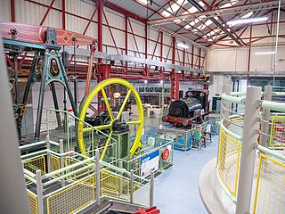
The Telford Steam Railway (TSR) is a heritage railway located at Horsehay, Telford in Shropshire, England, formed in 1976.

Madeley is a historic market town and civil parish in the borough of Telford and Wrekin, Shropshire, England. The parish had a population of 18,774 at the 2021 census.
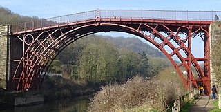
The Iron Bridge is a cast iron arch bridge that crosses the River Severn in Shropshire, England. Opened in 1781, it was the first major bridge in the world to be made of cast iron. Its success inspired the widespread use of cast iron as a structural material, and today the bridge is celebrated as a symbol of the Industrial Revolution.
The Ironbridge Gorge Museum Trust is an industrial heritage organisation which runs ten museums and manages multiple historic sites within the Ironbridge Gorge World Heritage Site in Shropshire, England, widely considered as the birthplace of the Industrial Revolution.

The Tar Tunnel is an abandoned tunnel located on the north bank of the River Severn in the Ironbridge Gorge at Coalport, England. It is one of ten Ironbridge Gorge Museums attractions administered by the Ironbridge Gorge Museum Trust.

Jackfield is a village in the Telford and Wrekin borough of Shropshire, England, lying on the south bank of River Severn in the Ironbridge Gorge, downstream from Ironbridge. Like many of the settlements in the area, it is notable for its place in the Industrial Revolution.

Jackfield Halt was an unstaffed request stop on the Severn Valley line in Shropshire, England. Originally opened at Jackfield, west of Maw and Company's private sidings in 1934, it comprised a simple wooden platform and shelter.

The Shropshire Canal was a tub boat canal built to supply coal, ore and limestone to the industrial region of east Shropshire, England, that adjoined the River Severn at Coalbrookdale. It ran from a junction with the Donnington Wood Canal ascending the 316 yard long Wrockwardine Wood inclined plane to its summit level, it made a junction with the older Ketley Canal and at Southall Bank the Coalbrookdale (Horsehay) branch went to Brierly Hill above Coalbrookdale; the main line descended via the 600 yard long Windmill Incline and the 350 yard long Hay Inclined Plane to Coalport on the River Severn. The short section of the Shropshire Canal from the base of the Hay Inclined Plane to its junction with the River Severn is sometimes referred to as the Coalport Canal.
The Tuckies is a hamlet in the eastern part of Jackfield, lying on the south bank of the River Severn, in the Ironbridge Gorge, and opposite the village of Coalport. The purpose of this article is to capture its historical importance during the industrial revolution and provide links to the people and culture that once thrived here. The lower part of The Tuckies, in Ferry Road, is still badly affected by flooding and head-height water levels are clearly displayed in a doorway at The Boat Inn where the 1922 memorial footbridge crosses the River Severn to Coalport. The Severn Valley railway, operated by GWR, ran through The Tuckies and the original railway bridge, now forming part of the Severn Valley Way, still crosses the road there, at OS grid reference 693024.
The lost village of Werps was one of a group of small settlements which later became collectively known as Jackfield in the Broseley Parish in Shropshire. The Werps lay on the south side of the river Severn, opposite the Old Coalport China Works and records indicate either three or four public houses, although it is unclear as to whether any of their names are renames of the same building or whether re-built on the same site.
Preens Eddy is a settlement on the south bank of the River Severn, opposite Coalport. Its history lies at the heart of the industrial revolution.

The Coalport branch line was a standard gauge London and North Western Railway branch line in Shropshire, England, which ran between Hadley Junction near Oakengates on the Stafford to Shrewsbury line and a terminus at Coalport East railway station on the north bank of the River Severn at Coalport.

The Museum of the Gorge, originally the Severn Warehouse, is one of the ten museums of the Ironbridge Gorge Museum Trust. It portrays the history of the Ironbridge Gorge and the surrounding area of Coalbrookdale, Shropshire, England.

The Silkin Way is a 14 mile walking and cycling route through Telford starting in Bratton and finishing in Coalport. In places the path follows the former Great Western Railway and the dry canal beds of the old Shropshire Canal and goes via Telford Town Centre and the Ironbridge Gorge World Heritage Site. Along the route the Silkin Way runs close to the many natural and historical features within Telford and shows great contrasts between futuristic architecture, woodlands, and mature parkland.


