City of Milton Keynes

Last updated

City of Milton Keynes
Motto(s): 
By knowledge, design and understanding
Milton Keynes UK locator map.svg
City of Milton Keynes, shown within Buckinghamshire and England
Coordinates: 52°07′N0°46′W / 52.117°N 0.767°W / 52.117; -0.767
Sovereign state United Kingdom
Constituent country England
Region South East
Ceremonial county Buckinghamshire
Incorporated 1 April 1974
Government
  Type Unitary authority
  Governing body Milton Keynes City Council
   MPs Iain Stewart (C) (Milton Keynes South)
Ben Everitt (C) (Milton Keynes North)
Area
[1]
  Total119.2 sq mi (308.6 km2)
Population
 (2021) [2]
  Total288,201
  Rank 53rd
  Density2,420/sq mi (934/km2)
Postcode
MK
Area code 01908
GSS code E06000042
Website milton-keynes.gov.uk

The City of Milton Keynes is a unitary authority area with both borough and city status, in Buckinghamshire. [3] It is the northernmost district of the South East England Region. The borough abuts Bedfordshire, Northamptonshire and the remainder of Buckinghamshire. [lower-alpha 1]

Contents

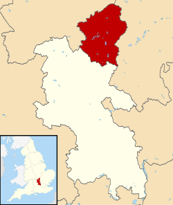
The principal built-up area in the borough is the Milton Keynes urban area, which accounts for about 20% of its area and 90% of its population. The borough also includes many rural areas surrounding the Milton Keynes urban area (especially to the north), containing several villages and the town of Olney. At the 2021 census, the population of the unitary authority area was just over 287,000. [4]

History

The district was created on 1 April 1974 under the Local Government Act 1972, covering the whole area of four former districts and part of a fifth, which were all abolished at the same time: [5]

The new district was named Milton Keynes (after its largest settlement). [6] The district was given borough status from its creation, allowing the chair of the council to take the title of mayor. [7]

As established in 1974, the borough of Milton Keynes was one of five non-metropolitan districts of Buckinghamshire, with Buckinghamshire County Council providing county-level services to the area. On 1 April 1997, Milton Keynes became a self-governing unitary authority by being redefined as its own non-metropolitan county, independent from Buckinghamshire County Council. [8] Milton Keynes remains part of the ceremonial county of Buckinghamshire for the purposes of lieutenancy. [9]

On 15 August 2022, letters patent were issued giving the borough the status of a city, allowing the council to change its name to Milton Keynes City Council. [3]

Local government

Arising from the local government elections of May 2021, the borough is governed by a Labour and Liberal Democrat coalition administration. The Conservative Party is the main opposition group.

As of January 2023, political composition of the council is as follows.

AffiliationCouncillors
Conservative Party17
Labour Party25
Liberal Democrats15

The 2022 local election did not change the status of the council from 'no overall control'. No political party has had an 'overall majority' on the council since 2006.

Economy

According to data from the Office for National Statistics for 2017, the borough was the highest performing NUTS3 region in the UK outside inner London (which takes the first five places), on the basis of gross value added per head. [10]

Education

Further education in the borough is provided by Milton Keynes College. For higher education, the Open University's headquarters are in Milton Keynes  though, as this is a distance education institution, the only students resident on campus are approximately 200 full-time postgraduates. A campus of the University of Bedfordshire located in Central Milton Keynes, provides conventional undergraduate courses.

Cranfield University is the academic partner in project with Milton Keynes City Council to establish a new university, code-named "MK:U", on a reserved site in the city centre. [11] As of January 2022, the project is stalled pending assurance of government funding. [12]

Demographics

Population

Population trend of borough and Urban Area 1801-2021. BofMiltonKeynesUA-popn.png
Population trend of borough and Urban Area 1801–2021.
Population of City of Milton Keynes (unitary authority area) in 2021 Milton Keynes population pyramid.svg
Population of City of Milton Keynes (unitary authority area) in 2021

At the 2021 census, the population of the borough was 287,060. [4] This was an increase of 15.3% from the 2011 census, when the population of the borough was 248,821. [15] By 2050, the City Council projects that the borough's population will reach 410,000. [16]

Education

At the 2021 census, of residents aged 16 and over, 15.8% had no qualifications, 10.9% had a level 1 qualification, 14.2% had level 2, 4.7% were in apprenticeship, 15.7% had level 3, 35.8% had level 4 and 2.9% had other qualifications.

Ethnicity

In the 2021 census, almost 71.8% of the population described their ethnic origin as white, 12.3% as Asian, 9.7% as black, 4% as mixed, and 2% as another ethnic group. [17]

Ethnic GroupYear
1991 [18] 2001 [19] 2011 [20] 2021 [17]
Number%Number%Number%Number%
White: Total166,10194.2%187,85290.7%199,09480%206,11471.8%
White: British 179,69486.8%183,93473.9%178,56862.2%
White: Irish 2,9182,4982,3820.8%
White: Gypsy or Irish Traveller 721560.1%
White: Roma5780.2%
White: Other 5,24012,5905.1%24,4308.5%
Asian or Asian British: Total5,9823.4%9,4064.5%22,7829.2%35,64512.3%
Asian or Asian British: Indian 2,8611.6%3,9671.9%8,1063.3%15,3485.3%
Asian or Asian British: Pakistani 8220.5%1,6820.8%3,8511.5%71632.5%
Asian or Asian British: Bangladeshi 6940.4%1,0720.5%1,9890.8%31891.1%
Asian or Asian British: Chinese 6670.4%1,8350.9%2,7221.1%29131.0%
Asian or Asian British: Other Asian9380.5%8500.4%6,1142.5%7,0322.4%
Black or Black British: Total2,8691.6%4,9862.4%17,1316.9%27,8519.7%
Black or Black British: African 5232,59613,0585.2%21,5027.5%
Black or Black British: Caribbean 1,6651,9562,5242,9751.0%
Black or Black British: Other Black 6814341,5493,3741.2%
Mixed or British Mixed: Total3,7161.8%8,2353.3%11,7254%
Mixed: White and Black Caribbean1,3472,2432,9971.0%
Mixed: White and Black African4771,5972,5510.9%
Mixed: White and Asian1,0372,2282,9731.0%
Mixed: Other Mixed8552,1673,2041.1%
Other: Total1,3780.8%1,0970.5%1,5790.6%5,7252%
Other: Arab56513490.5%
Other: Any other ethnic group1,3780.8%1,0970.5%1,0140.4%43761.5%
Ethnic minority: Total10,2295.8%19,2059.3%49,72720%80,94628%
Total176,330100%207,057100%248,821100%287,060100%

Religion

At the 2021 census, 62% professed a religious belief. Christianity is the largest denomination, with almost 43% of the total. [4]

Religion2001 [21] 2011 [22] 2021 [4]
Number%Number%Number%
Holds religious beliefs145,98370.5154,44462.1178,10762.0
Gold Christian Cross no Red.svg Christian 135,71565.5131,35252.8122,93542.8
Dharma Wheel.svg Buddhist 7470.41,2460.51,4040.5
Om.svg Hindu 2,5961.36,9182.812,9114.5
Star of David.svg Jewish 4660.24270.13830.1
Star and Crescent.svg Muslim 4,8432.311,9134.820,4847.1
Khanda.svg Sikh 7950.41,3720.61,9590.7
Other religion8210.41,2160.51,5580.5
No religion and Religion not stated61,07429.594,37737.9125,42643.7
No religion 44,63321.677,93931.3108,95338.0
Religion not stated16,4417.916,4386.616,4735.7
Total population207,057100.0248,821100.0287,060100.0

Housing and home ownership

Household tenure breaks down to 60.8% of dwellings owner-occupied, 21% of homes privately rented and 18% are socially rented. [4] Due to the borough's fast-growing population, the City Council plans for a minimum of 26,500 dwellings across the borough over the period between 2016 and 2031, with development primarily focused on city estates, expansion areas and strategic land locations in the south and east of Milton Keynes, Campbell Park (in CMK) and the three "Key Settlements" outside of the 1967 "designated development area" of Milton Keynes: Newport Pagnell, Woburn Sands and Olney. [23]

Public health

According to Public Health England, "The health of people in Milton Keynes is generally similar to the England average. About 15.1% (8,680) children live in low income families. Life expectancy for both men and women is similar to the England average." [24]

Settlements

Milton Keynes urban area

The urban area accounts for about 20% of the borough by area and 90% by population. This is a partial list of the districts of the Milton Keynes urban area.

The City of Milton Keynes is fully parished. These are the parishes, and the districts they contain, that are now elements of the Milton Keynes built-up area as defined by the Office for National Statistics. [25] [lower-alpha 2] Bletchley, Fenny Stratford, Woburn Sands, Central Milton Keynes, Newport Pagnell, Wolverton and Stony Stratford are all towns.

Rest of the borough

The rural area accounts for about 80% of the borough by area and about 10% by population. Olney is a town. These are the extra-urban civil parishes:

Neighbourhood Plans

As of December 2023, the borough has 28 designated Neighbourhood Areas, of which 22 have made/adopted Neighbourhood Development Plans approved by the City Council, spanning both urban and rural parishes. [26]

Freedom of the City

The following people and military units have received the Freedom of the City (from 2022) or Freedom of the Borough (19822021).

Individuals

Military Units

Organisations and businesses

Related Research Articles

<span class="mw-page-title-main">Milton Keynes</span> City in Buckinghamshire, England

Milton Keynes is a city in Buckinghamshire, England, about 50 miles (80 km) north-west of London. At the 2021 Census, the population of its urban area was 264,349. The River Great Ouse forms the northern boundary of the urban area; a tributary, the River Ouzel, meanders through its linear parks and balancing lakes. Approximately 25% of the urban area is parkland or woodland and includes two Sites of Special Scientific Interest (SSSIs).

<span class="mw-page-title-main">Bletchley</span> Human settlement in England

Bletchley is a constituent town of Milton Keynes, Buckinghamshire, England. It is situated in the south-west of the city, and is split between the civil parishes of Bletchley and Fenny Stratford and West Bletchley.

<span class="mw-page-title-main">Wolverton</span> Human settlement in England

Wolverton is a constituent town of Milton Keynes, England. It is located in the north-west of the city, beside the West Coast Main Line, the Grand Union Canal and the river Great Ouse. It is the administrative seat of Wolverton and Greenleys civil parish.

<span class="mw-page-title-main">North East Milton Keynes (UK Parliament constituency)</span> Parliamentary constituency in the United Kingdom 1992-2010

North East Milton Keynes was a county constituency represented in the House of Commons of the Parliament of the United Kingdom from 1992 to 2010. It elected one member of parliament (MP) by the first past the post system of election.

<span class="mw-page-title-main">Milton Keynes South West (UK Parliament constituency)</span> Parliamentary constituency in the United Kingdom 1992-2010

Milton Keynes South West was a constituency represented in the House of Commons of the Parliament of the United Kingdom from 1992 to 2010. It elected one Member of Parliament (MP) by the first past the post system of election.

<span class="mw-page-title-main">Buckingham (UK Parliament constituency)</span> Parliamentary constituency in the United Kingdom since 1542

Buckingham is a constituency represented in the House of Commons of the UK Parliament since 2019 by Greg Smith, a Conservative.

<span class="mw-page-title-main">Newport Pagnell Rural District</span>

Newport Pagnell was a rural district in the administrative county of Buckinghamshire, England, from 1894 to 1974, covering an area in the north-east of the county.

<span class="mw-page-title-main">New Bradwell</span> Civil parish in Milton Keynes, England

New Bradwell is (mainly) an Edwardian era village, modern district and civil parish in north-west Milton Keynes, Buckinghamshire, England, about 2 miles (3.2 km) north-west of Central Milton Keynes. Together with Wolverton, it was built primarily to house the workers on the Wolverton railway works.

Bletchley and Fenny Stratford is a civil parish with a town council, in Milton Keynes, Buckinghamshire, England. It was formed in 2001 from the unparished area of Milton Keynes, and according to the 2011 census had a population of 15,313. Together with West Bletchley, it forms the Bletchley built-up area.

<span class="mw-page-title-main">Milton Keynes (UK Parliament constituency)</span> Parliamentary constituency in the United Kingdom 1983-1992

Milton Keynes was a borough constituency represented in the House of Commons of the Parliament of the United Kingdom from 1983 until 1992.

<span class="mw-page-title-main">Milton Keynes North (UK Parliament constituency)</span> Parliamentary constituency in the United Kingdom since 2010

Milton Keynes North is a constituency represented in the House of Commons of the UK Parliament since the 2019 United Kingdom general election by Ben Everitt, a Conservative.

<span class="mw-page-title-main">Milton Keynes South (UK Parliament constituency)</span> Parliamentary constituency in the United Kingdom since 2010

Milton Keynes South is a constituency represented in the House of Commons of the UK Parliament since its 2010 creation by Iain Stewart, a Conservative.

Sport in Milton Keynes covers a range of professional and amateur sport in the City of Milton Keynes unitary authority area. In 2019, Milton Keynes was officially designated as a European City of Sport for 2020. There are professional teams in football, in motorsport and in ice hockey. The National Badminton Centre, and the Marshall Milton Keynes Athletic Club train professional and amateur athletes. Most other sports feature at amateur level although there are semi-professional teams in rugby union and football among other sports. There is an international-standard karting track owned by Daytona Motorsport.

<span class="mw-page-title-main">History of Milton Keynes</span> History of the city in England

This history of Milton Keynes details its development from the earliest human settlements, through the plans for a 'new city' for 250,000 people in northern Southeast England, its subsequent urban design and development, to the present day. Milton Keynes, founded in 1967, is the largest settlement and only city in Buckinghamshire. At the 2021 census, the population of its urban area was estimated to have exceeded 256,000.

<span class="mw-page-title-main">MK Metro</span> Bus line based in Milton Keynes, Buckinghamshire

MK Metro was a bus company operating in Milton Keynes from 1997 until 2010.

<span class="mw-page-title-main">Milton Keynes grid road system</span> Top layer of street hierarchy

The Milton Keynes grid road system is a network of predominantly national speed limit, fully landscaped routes that form the top layer of the street hierarchy for both private and public transport in Milton Keynes, Buckinghamshire. The system is unique in the United Kingdom for its innovative use of street hierarchy principles: the grid roads run in between districts rather than through them. This arrangement permits higher speed limits due to the absence of buildings close to the roads – although more recently some have been limited in part to 40 mph (64 km/h). The grid road system also serves an important purpose of discouraging through-traffic from travelling through neighborhoods and thus reduces traffic noise and pollution in pedestrian areas. Motor traffic is segregated from pedestrian and leisure cycling traffic, which uses the alternative Milton Keynes redway system. Almost all grid junctions are roundabouts, and the absence of traffic lights enables free and efficient movement of traffic.

Milton Keynes City Council is the local authority for the City of Milton Keynes, a unitary authority in Buckinghamshire, England. Until 1 April 1997 it was a non-metropolitan district.

References

  1. "Mid-Year Population Estimates, UK, June 2021". Office for National Statistics. 21 December 2022. Retrieved 18 October 2023.
  2. "Mid-Year Population Estimates, UK, June 2021". Office for National Statistics. 21 December 2022. Retrieved 18 October 2023.
  3. 1 2 "Crown Office | The Gazette". www.thegazette.co.uk. Retrieved 19 August 2022.
  4. 1 2 3 4 5 UK Census (2021). "2021 Census Area Profile – Milton Keynes Local Authority (E06000042)". Nomis. Office for National Statistics . Retrieved 18 September 2023.
  5. "The English Non-metropolitan Districts (Definition) Order 1972", legislation.gov.uk , The National Archives, SI 1972/2039, retrieved 25 April 2023
  6. "The English Non-metropolitan Districts (Names) Order 1973", legislation.gov.uk , The National Archives, SI 1973/551, retrieved 25 April 2023
  7. "District Councils and Boroughs". Parliamentary Debates (Hansard) . 28 March 1974. Retrieved 16 January 2012.
  8. "The Buckinghamshire (Borough of Milton Keynes) (Structural Change) Order 1995". Government of the United Kingdom . Retrieved 15 July 2020. (2) A new county shall be constituted comprising the area of Milton Keynes and shall be named the county of Milton Keynes.
  9. "Lieutenancies Act 1997", legislation.gov.uk , The National Archives, 1997 c. 23, retrieved 26 April 2023
  10. Statistical bulletin: Regional gross value added (balanced), UK: 1998 to 2017 (table 7) (Report). Office for National Statistics. 12 December 2018.
  11. "Project Two: MK:U A new University for Milton Keynes". MK2050 Futures Commission. October 2017. Retrieved 6 February 2019.
  12. "Milton Keynes: New university project for 2023 delayed". BBC News. 7 January 2022. Retrieved 15 February 2022.
  13. Source: Vision of Britain, Office for National Statistics
  14. "Sex by age - Office for National Statistics". www.ons.gov.uk. Retrieved 15 June 2023.
  15. "Census: East of England has biggest population rise since 2011". BBC News. 28 June 2022. Retrieved 12 February 2023.
  16. "STRATEGY FOR 2050 NEW DESIGN" (PDF). MK2050 Futures Commission. March 2022. Retrieved 12 December 2023.
  17. 1 2 "Ethnic group - Office for National Statistics". www.ons.gov.uk. Retrieved 29 November 2022.
  18. Data is taken from United Kingdom Casweb Data services of the United Kingdom 1991 Census on Ethnic Data for England, Scotland and Wales (Table 6)
  19. "Office for National Statistics; 2001 Census Key Statistics". webarchive.nationalarchives.gov.uk. Retrieved 7 September 2021.
  20. "2011 Census: Ethnic Group, local authorities in England and Wales". webarchive.nationalarchives.gov.uk. Retrieved 15 December 2021.
  21. "KS007 - Religion - Nomis - 2001". www.nomisweb.co.uk. Retrieved 18 October 2022.
  22. "KS209EW (Religion) - Nomis - 2011". www.nomisweb.co.uk. Retrieved 18 October 2022.
  23. "Plan:MK 2016-2031" (PDF). Milton Keynes City Council. Retrieved 12 December 2023.
  24. "Local Authority Health Profile 2019: Milton Keynes". Public Health England. 2019. Retrieved 22 August 2020.
  25. UK Census (2011). "Local Area Report – Milton Keynes Built-up area (E34005056)". Nomis. Office for National Statistics . Retrieved 29 March 2019. (includes map of the built-up area).
  26. "Neighbourhood Plans in Milton Keynes". Milton Keynes City Council. Retrieved 13 December 2023.
  27. 1 2 3 4 5 6 David Tooley (15 May 2020). "Tories want key workers in Milton Keynes to be awarded freedom of the borough". Milton Keynes Citizen. Retrieved 4 August 2020.
  28. "Football boss 'overwhelmed' by award". BBC News. 22 August 2015.
  29. "Proud city centre military march to commemorate Freedom of the Borough - Milton Keynes Council". www.milton-keynes.gov.uk.
  30. "Congratulations to MK's Leah Williamson and The Lionesses". Milton Keynes Council. 1 August 2022.
  31. Sally Murrer (28 February 2023). "England captain Leah Williamson awarded Freedom of the City of Milton Keynes". Milton Keynes Citizen. Retrieved 3 March 2023.
  32. "Rifles squadron rewarded for service with 'Freedom of Milton Keynes' honour". ITV News. 11 March 2018.
  1. The remainder of Buckinghamshire is also a Unitary Authority and is controlled by Buckinghamshire Council.
  2. This list excludes the civil parishes of Aspley Guise and Aspley Heath which, despite being in the contiguous built-up area, are in Central Bedfordshire and thus outside the City of Milton Keynes.