Stantonbury is a district and civil parish of Milton Keynes, Buckinghamshire, England, situated roughly 2 miles (3.2 km) north of Central Milton Keynes. [2] The toponym Stanton is derived from an Old English term for "stone-built farmstead" and the bury element from the French family Barri who held it in 1235. [3] [4] The original Stantonbury is a deserted medieval village now known as Stanton Low; [5] the Stantonbury name has been reused for the modern district at the heart of the civil parish.
As well as Stantonbury itself, the civil parish of Stantonbury includes the districts of Bancroft and Bancroft Park, Blue Bridge, Bradville and Linford Wood. The population of the parish of Stantonbury grew from 19 at the 1971 census to 3,938 according to the 1981 census. By the time of the 2001 census its population had reached 9,010. [6] At the 2011 census, it had 10,084 people. [1]
The residential Bancroft district is divided by Shenley Brook into Bancroft Park to the west and Bancroft to the east. The brook valley here is part of the flood control system and is a linear park for most of the year. There is a permanent wetland with associated plants and wildlife.
The foundations of a Romano-British farm known as Bancroft Roman Villa are in what is now the North Loughton Park, overlooking the Shenley Brook. [7] (map) Rescue excavations in 1957 identified a group of perhaps four buildings, traces of a hypocaust and sherds of Iron Age pottery. [8] A section of mosaic flooring recovered from the site is in the "guest services lounge" of Central Milton Keynes shopping centre. [9]
A copy of the famous Concrete Cows sculpture is at the southern end of the park (the original is in the Milton Keynes Museum). The Cows were originally sited here.
Bancroft is a haven for birds and one of the best places to see a common kingfisher. This is because of the wide variety of habitats the Parks Trust has created, from old grassland managed as wildflower meadows, through patches of thorn scrub to extensive marsh. cowslips and salad burnet flower in the spring, followed in summer to the customary flowers of traditional hay meadow: lady's bedstraw and birdsfoot trefoil.
Bancroft pétanque Piste, which is near the Roman villa site, is provided by the Parks Trust free of charge. Also known as boules, pétanque is a traditional game played with steel balls on any sandy or gravelly surface across a large part of Europe.
The Bancrofts comprise just half the H2/H3/V5/V6 grid square, which is divided by the West Coast Main Line; the line is also the parish boundary, with Stacey Bushes (in Wolverton and Greenleys parish) on the other side of the tracks. Monks Way (H3, A422) bounds the parish from the neighbouring Bradwell.
This small district is mainly residential, near the West Coast Main Line and the Grand Union Canal (which separates it from Stonebridge, the rest of the grid square). It is also home to its own residential club, which it shares with Bancroft Park. [10] The 'Blue Bridge' (1834–5), now restricted to pedestrian and cycle traffic, is one of the oldest bridges over the West Coast Main Line and is a Grade II listed structure. [11]
This district, between Bradwell, New Bradwell and Stantonbury itself, is mainly residential. The windmill is a Grade II listed building. [12]
As well as the ancient woodland that gives it its name, this district is mainly for high-tech industry. It is best known in Milton Keynes as the site of the telecommunications tower, for which it was chosen for its high elevation. It was originally part of the Linford demesne.
This small district of private housing development, part of the northern expansion of Milton Keynes outside its 1967 designated boundary, dates from about 2010.[ citation needed ] There is a small local centre with an Asda supermarket, a pharmacy and other small shops.
This district lies north of Central Milton Keynes, between Great Linford and Wolverton, and south of Oakridge Park. It is largely residential, but the greater proportion of the area is taken up by two secondary schools (Stantonbury School and the Webber Independent School), a Theatre, leisure centre with a 25m swimming pool and an all-weather, competition standard, athletics track.
Modern Stantonbury lies on land historically known as "Stanton High" (as opposed to "Stanton Low"). [13]
Stanton Low lies near the River Great Ouse and is the deserted village of historic Stantonbury, [14] one of the rural Buckinghamshire villages that were included in the area designated in 1967 to become Milton Keynes. Today this is an uninhabited agricultural area near the river. Little if anything remains of the deserted village other than the ruins of the parish church of St Peter. In the late 1950s the ruins of a Roman villa were discovered here, but were completely destroyed by gravel extraction. [15]
The former Church of England parish church of Saint Peter in Stanton Low (map) is Norman, with a mid-12th century nave and even earlier chancel. [14] There was a squint in the south wall of the chancel, but this was later blocked. [14] St. Peter's was extensively rebuilt in the 13th century; the Decorated Gothic east window and piscina were added in the 14th century. [14] By the latter part of the 17th century Stantonbury was almost deserted but the church was still in use; between 1668 and 1674 the Puritan poet and hymnwriter John Mason was its parish priest. [14] In 1736 only four houses remained in the village, [14] but St Peter's was still in use in 1927 [14] and John Piper painted a watercolour of it in about 1940. [16] By 1955 the church had been disused for a number of years; the following year the roof collapsed. [13] and was not repaired. By 1973 St. Peter's was a ruin, and the east window and ornamented Norman chancel arch had been removed [8] (in 1963, to the Church of St James in New Bradwell. [17] ) The building is a Grade II listed building. [18]
Because the civil parish boundary runs along the canal, St Peter's is actually in Haversham-cum-Little Linford civil parish. [17]
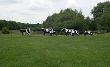
Milton Keynes is a city in Buckinghamshire, England, about 50 miles (80 km) north-west of London. At the 2021 Census, the population of its urban area was 264,349. The River Great Ouse forms the northern boundary of the urban area; a tributary, the River Ouzel, meanders through its linear parks and balancing lakes. Approximately 25% of the urban area is parkland or woodland and includes two Sites of Special Scientific Interest (SSSIs).
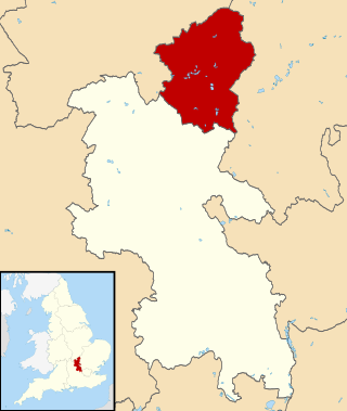
The City of Milton Keynes is a borough with city status, in Buckinghamshire, England. It is the northernmost district of the South East England Region. The borough abuts Bedfordshire, Northamptonshire and the remainder of Buckinghamshire. The borough is administered by Milton Keynes City Council, a unitary authority.
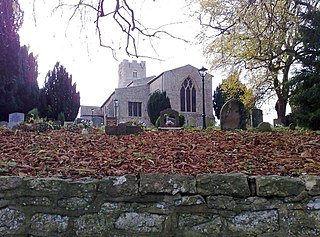
Bradwell is an ancient village and modern district in Milton Keynes, Buckinghamshire, England, situated approximately 1 mile (1.6 km) north-west of Central Milton Keynes. It has also given its name to a modern civil parish that is part of the City of Milton Keynes. The village was adjacent to Bradwell Abbey, a Benedictine priory, founded in 1155 and dissolved in about 1540, but the abbey and its immediate environs were always a separate ecclesiastical parish.
Great Linford is a historic village, district and wider civil parish in the north of Milton Keynes, England, between Wolverton and Newport Pagnell, and roughly 2 miles (3.2 km) north of Central Milton Keynes.
Haversham is a village and former civil parish, now in the parish of Haversham-cum-Little Linford, in the City of Milton Keynes unitary authority area, in Buckinghamshire, England. It is situated to the north of the Milton Keynes urban area, near Wolverton and about 5 miles (8 km) north of Central Milton Keynes.
Shenley Brook End is a village, district and wider civil parish in Milton Keynes, Buckinghamshire, England, located about 2 miles (3.2 km) north-west of Bletchley, and 2.5 miles (4.0 km) south-west of Central Milton Keynes. Together with its neighbouring districts of Shenley Church End, Shenley Wood and Shenley Lodge, the districts are collectively known as "The Shenleys".
North East Milton Keynes was a county constituency represented in the House of Commons of the Parliament of the United Kingdom from 1992 to 2010. It elected one member of parliament (MP) by the first past the post system of election.
Milton Keynes South West was a constituency represented in the House of Commons of the Parliament of the United Kingdom from 1992 to 2010. It elected one Member of Parliament (MP) by the first past the post system of election.
Newport Pagnell was a rural district in the administrative county of Buckinghamshire, England, from 1894 to 1974, covering an area in the north-east of the county.
New Bradwell is (mainly) an Edwardian era village, modern district and civil parish in north-west Milton Keynes, Buckinghamshire, England, about 2 miles (3.2 km) north-west of Central Milton Keynes. Together with Wolverton, it was built primarily to house the workers on the Wolverton railway works.
Bradwell Abbey or Bradwell Priory is a scheduled monument, urban studies site, district and former civil parish in Milton Keynes, Buckinghamshire, England. The site was once the location of a Benedictine priory, founded in 1155.
Milton Keynes North is a constituency represented in the House of Commons of the UK Parliament since the 2024 general election by Chris Curtis for the Labour Party.
Sport in Milton Keynes covers a range of professional and amateur sport in the City of Milton Keynes unitary authority area. In 2019, Milton Keynes was officially designated as a European City of Sport for 2020. There are professional teams in football, in motorsport and in ice hockey. The National Badminton Centre, and the Marshall Milton Keynes Athletic Club train professional and amateur athletes. Most other sports feature at amateur level although there are semi-professional teams in rugby union and football among other sports. There is an international-standard karting track owned by Daytona Motorsport.
This history of Milton Keynes details its development from the earliest human settlements, through the plans for a 'new city' for 250,000 people in northern Southeast England, its subsequent urban design and development, to the present day. Milton Keynes, founded in 1967, is the largest settlement and only city in Buckinghamshire. At the 2021 census, the population of its urban area was estimated to have exceeded 256,000.
MK Metro was a bus company operating in Milton Keynes from 1997 until 2010.
Milton Keynes City Council is the local authority and unitary authority for the City of Milton Keynes, a borough in Buckinghamshire, England.
Whitehouse is a neighbourhood and civil parish that covers a large new development area on the western flank of Milton Keynes, Buckinghamshire, England. As the first tier of Local Government, its community council is responsible for the people, living and working in this area of Milton Keynes. In 2021 the parish had a population of 3341.