Civil parish and central business district in England
Central Milton Keynes
Civil parish and central business district
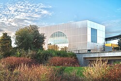
Top to bottom, left to right: Hotel La Tour from Campbell Park; the Xscape dome; Milton Keynes Gallery; the arc (almost) joining the Midsummer Place and the Centre:MK
The district is approximately 3.5km (2.2mi) long by 1km (0.6mi) wide and occupies some of the highest land in the city.[2] It contains (behind the Central Library) the historic site of the moot hill for Secklow (or Sigelai) Hundred.[3] It is the site of the central retail, business, law enforcement and governmental districts, Milton Keynes Central railway station and around 2,000 residential dwellings.
Topology
Occupying 342 hectares (850 acres),[4] the district lies between Portway (H5, A509) to the north, the West Coast Main Line and A5 to the west, Childs Way (H6) to the south and the Grand Union Canal to the east. It is crossed from north to south by (in west to east order, major roads only) Grafton Gate (V6), Witan Gate, Saxon Gate (V7) and Secklow Gate, and Marlborough Street. It is crossed from west to east (in north to south order, major roads only) by Silbury Boulevard, Midsummer Boulevard and Avebury Boulevard. Midsummer Boulevard is the primary spine.
The district rests like a saddle across a long north-south ridge with its highest point here at a little over 110 metres (360ft), falling east to 75 metres near the Grand Union Canal and 85 metres near the Central railway station.[2] This area is almost[b] the highest point of Milton Keynes and includes the site of Secklow Mound,[5] the moot mound (meeting place) for the Secklow Hundred and a scheduled ancient monument,[6] just behind the central library.
Astronomical alignment
Midsummer sunrise is somewhere to the east– not actually on the alignment of Midsummer Boulevard: [...] But it was a good urban myth to lay down. Let's call that road Midsummer Boulevard because you could tell people that on Midsummer's Day, the sun rises at the end of it, which it nearly does. And the other two? We'll refer to our Anglo-Saxon heritage, because this is not an American new town... It's an English new town, in an English place, on a Common, where three Saxon Hundreds used to meet at that little mound behind the library. So we refer to Avebury and Silbury as being part of our historical and cultural references.
I've always been interested in astronomy. It's something you've got to know as an architect when you're designing buildings: where [does] the sun rise in winter? Where [does] it set in summer? You've got to know that, otherwise you don't know where you're putting your building in relation to the cosmos. That goes in pretty early.
While still on the drawing board, planners noticed that the planned main streets in the proposed city centre would almost frame the rising sun on Midsummer's Day.[8][c] This story has become embellished over time and, according to subsequent reports, they consulted Greenwich Observatory to obtain the exact angle required at the latitude of CMK, and persuaded the engineers to shift the grid of roads a few degrees in response.[10][11] Physical reality does not match this report. From the highest point on Midsummer Boulevard, where the eastward horizon is unobstructed, the sunrise at 'first flash' is not aligned with the Boulevard.[12] In reality, the sun is somewhat elevated before alignment occurs, 40 minutes later.[13]
This area is defined by the Marlborough Street (V8, B4034) to the north-east, the Saxon Gate (Saxon Street, V7) to the south-west, Portway (H5, A509) to the north-west and Childs Way (H6) to the south-east. The core retail district is further delimited by Silbury and Avebury Boulevards, with civic and office developments outside the Boulevards.
The Secklow Mound (the original Anglo-Saxon centre of the district), the central library, civic offices of Milton Keynes City Council and other commercial offices are on the north side of Silbury Boulevard, which separates them from the shops. Midsummer Boulevard runs along the south side of the Centre:MK, separating the shops from the theatre, the municipal art gallery, Theatre District, the Xscape building, pubs, sports shops and other leisure facilities.
Xscape Milton Keynes is the main leisure complex in Central Milton Keynes consisting of SnoZone, a real snow indoor ski slope, a multiscreen cinema, and a number of shops, restaurants and night clubs. At the rear of the site is iFly, an indoor skydiving column.
Theatre and municipal art gallery
The municipal public art gallery, MK Gallery, presents exhibitions of international contemporary and classical art.[18] The gallery was extended and remodelled in 2018/19 and includes an art-house cinema.[19][20] It does not have a permanent collection.
The adjacent 1,400-seat Milton Keynes Theatre opened in 1999.[21] The theatre has an unusual feature: the ceiling can be lowered closing off the third tier (gallery) to create a more intimate space for smaller-scale productions.[21][22]
West of Saxon Gate, east of Grafton Gate: the main business district
Ecumenical Church of Christ the Cornerstone
This area is also delimited by Portway and Childs Way. Saxon Gate separates it from the north-east area and Grafton Gate (Grafton Street, V7) marks its south-western edge. The domed Church of Christ the Cornerstone, law courts and police station are in the business district, beside the small linear Fred Roche Gardens and Grafton Park that provides its core.
This ecumenical church, the first such in the United Kingdom, is shared by the major Christian denominations to serve the office workers and the small resident population. (There are many denominational places of worship elsewhere in Milton Keynes).
The Hub:MK
Multi-story apartments and Jury's Inn hotel form 'The Hub'
The Hub:MK is a 2006-built development between the station and the church, consisting of towers ranging between 10 and 14 storeys. The complex includes two high-rise hotels and a number of residential and office towers set around a central piazza. The site controversially involves the closure of one of the original pedestrian underpasses and is built right up to the edge of the adjacent boulevard, the first of several proposals that would have changed the unique character of Milton Keynes Development Corporation's original design for Central Milton Keynes. The work is part of the 'densification' plan that central government, through its agency English Partnerships, had ordained for Milton Keynes. Its height, also a major departure from the original low-rise design, makes it the third tallest building in Milton Keynes, beaten only by the 14-storey Xscape and the 18-storey Mellish Court in Bletchley.
To the south of the Hub lies a similar development named Vizion. This is similar in height and layout to the Hub but features a large Sainsbury's supermarket taking up the lower two floors with a rooftop garden above it. Vizion was completed in 2009, whilst the following year saw the completion of the 9-storey Pinnacle office development further west along Midsummer Boulevard from the Hub, closer to the railway station. The latter is distinctive for the slanted roof on its tallest section.
Higher education
As of 2022[update], Milton Keynes does not have its own conventional undergraduate university, though it contains the campus of the national Open University. There is an outpost of the University of Bedfordshire in a CMK office block.[23]
Cranfield University and the Milton Keynes City Council are partners in a detailed proposal to establish an undergraduate campus, code-named MK:U.[24][25] The plan anticipates opening by 2023,[25] with a campus in the block contained by Grafton Street / Avebury Boulevard / Witan Gate / Childs Way. In January 2019, the partners announced an international competition to design the new campus.[26] In May 2019, Santander Bank announced a 'seed funding' grant of £30M to help with building and initial running costs.[25] On 4 July 2019, the shortlisted proposals for the campus were announced.[27] On 30 July 2019, the evaluation panel announced that Hopkins Architects had produced the winning design.[28]
As of January 2022[update], the project is stalled pending assurance of government funding.[29]
This district is defined by Saxon Gate (Saxon Street, V7) to the north-east, the West Coast Main Line (and the adjacent A5) to the south-west, Portway (H5, A509) to the north-west and Childs Way (H6) to the south-east. The core retail district is further delimited by Silbury and Avebury Boulevards, with civic and office developments outside the Boulevards.
The main feature of the district is the Milton Keynes Central railway station (an inter-city stop on the West Coast Main Line), one of the seven[d] stations serving the Milton Keynes urban area. The buildings around Station Square house commercial offices, residential flats, food outlets a gym.
The former central bus station is located opposite the railway station but has not been operating as such since 1997.[citation needed] Beside the building, a young peoples' facility, 'the Buszy' includes an award-winning covered "urban" skate-boarding area, which has attracted international 'skaters' and film crews.
Also opposite the station, "Unity Place" is Santander UK's primary operations base outside London and nearby, Quadrant:MK has a similar function for Network Rail.[30] To the south of the station, the 'Leisure Plaza' is another leisure and retail area that includes the Planet Ice Arena (home of Milton Keynes Lightning).
For the 2001 Census, the Office for National Statistics designated an urban sub-area that it called "Central Milton Keynes". This was far bigger than either the district or the parish. Since the 2011 Census, this nomenclature is no longer used.
Media
Locations around Central Milton Keynes were used for the movie Superman IV: The Quest for Peace, where it played the part of the United Nations building. Recognisable locations include Milton Keynes Central, CBX and the Argos (now Home Retail Group) building on Avebury Boulevard.[32]
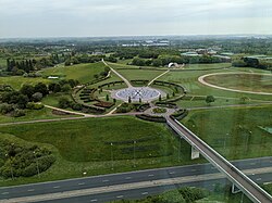
↑Campbell Park itself is indeed in CMK parish. It was transferred there from Campbell Park CP but the latter's Community Council has retained the original name/
↑Adkins, R; Petchey, M. (1984). "Secklow hundred mound and other meeting place mounds in England". Archaeological Journal. 141: 243–251. doi:10.1080/00665983.1984.11077777.
↑"Light Pyramid". Milton Keynes Parks Trust. (It is not a "temple to the sun".)
↑"Campbell Park". The Parks Trust. October 2019. Retrieved 2 December 2019. ⚠ Sheep are back in Campbell Park - October 2019. Please can we urge all dog walkers and owners to please ensure dogs are kept on lead in any of our grazing fields in these areas. We appreciate your support in looking after our sheep.
This page is based on this Wikipedia article Text is available under the CC BY-SA 4.0 license; additional terms may apply. Images, videos and audio are available under their respective licenses.