
Milton Keynes is the only city and the largest settlement in Buckinghamshire, England, about 50 miles (80 km) north-west of London. At the 2011 Census, the population of its urban area was almost 230,000. The River Great Ouse forms its northern boundary; a tributary, the River Ouzel, meanders through its linear parks and balancing lakes. Approximately 25% of the urban area is parkland or woodland and includes two Sites of Special Scientific Interest (SSSIs).

The City of Milton Keynes is a unitary authority area with borough and city status, in the ceremonial county of Buckinghamshire. It is the northernmost district of the South East England Region. The borough abuts Bedfordshire, Northamptonshire and the remainder of Buckinghamshire.
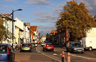
Newport Pagnell is a town and civil parish in the City of Milton Keynes, Buckinghamshire, England. The Office for National Statistics records Newport Pagnell as part of the Milton Keynes urban area.
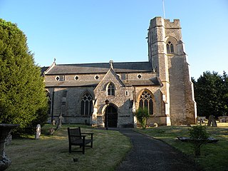
Emberton is a village and civil parish in the unitary authority area of the City of Milton Keynes, in Buckinghamshire, England. The village is near the borders with Northamptonshire and Bedfordshire, just to the south of Olney and four miles north of Newport Pagnell.

Tattenhoe and Tattenhoe Park are adjacent neighbourhoods of Milton Keynes, England, in the ancient ecclesiastic parish of Tattenhoe. They are located at the south-western edge of the city, next to Whaddon in Aylesbury Vale, not far from the ruins of Snelshall Priory.

A balancing lake is a term used in the U.K. describing an element of an urban drainage system used to control flooding by temporarily storing flood waters. The term balancing pond is also used, though typically for smaller storage facilities for streams and brooks.

The London Borough of Croydon has over 120 parks and open spaces within its boundaries, ranging from the 200 acre (80ha) Selsdon Wood Nature Reserve to many recreation grounds and sports fields scattered throughout the Borough. Croydon covers an area of 86.52 km², the 256th largest district in England. Croydon's physical features consist of many hills and rivers that are spread out across the borough and into the North Downs, Surrey and the rest of South London. Some of the open spaces in Croydon form part of the well-known London LOOP walks where the first section was opened on 3 May 1996 with a ceremony on Farthing Downs in Coulsdon. As a borough in Outer London it also contains some open countryside in the form of country parks. Croydon Council is associated with several other boroughs who are taking part in the Downlands Countryside Management Project. These boroughs are Sutton; and by Surrey County Council; the City of London Corporation; the Surrey districts of Reigate and Banstead and Tandridge; and the Countryside Agency. An additional partner is Natural Britain.

Central Milton Keynes is the central business district of Milton Keynes, Buckinghamshire, England and a civil parish in its own right, with a town council.

Campbell Park is the name of the central park for Milton Keynes (England) and of a ward of Central Milton Keynes civil parish..

The Milton Keynes redway system is an over 200 miles network of shared use paths for cyclists and pedestrians in Milton Keynes, Buckinghamshire, England. It is generally surfaced with red tarmac, and criss-crosses most of the city.
In January 2004, Deputy Prime Minister John Prescott announced the United Kingdom government's Expansion plans for Milton Keynes However, the change of government in 2010 and the abolition of the Regional Spatial Strategy in 2012/13 saw these plans revoked and a planned expansion of up to 44,000 dwellings reduced to 28,000. The Milton Keynes Core Strategy was published in July 2013 and regards the figure of 28,000 new homes to be the minimum figure.

Norwood Park is a 13.3-hectare (33-acre) park located in West Norwood. The park is bordered by Elder Road, Central Hill and Salter's Hill in South East London.

This history of Milton Keynes details its development from the earliest human settlements, through the plans for a 'new city' for 250,000 people in northern Southeast England, its subsequent urban design and development, to the present day. Milton Keynes is the largest settlement and only city in Buckinghamshire, founded in 1967. At the 2011 census, the population of its urban area was estimated to have reached almost 230,000.

MK Metro was a bus company operating in Milton Keynes from 1997 until 2010.

The Milton Keynes grid road system is a network of predominantly national speed limit, fully landscaped routes that form the top layer of the street hierarchy for both private and public transport in Milton Keynes, Buckinghamshire. The system is unique in the United Kingdom for its innovative use of street hierarchy principles: the grid roads run in between districts rather than through them. These facilitate higher speed limits due to the absence of buildings close to the roads, although more recently the initial concept has been eroded somewhat by making some of the grid roads 40mph. The grid road system also serves an important purpose of discouraging traffic from travelling through housing districts and reducing traffic noise and pollution from pedestrian areas. Traffic is segregated from pedestrian and leisure cycling traffic, which uses the alternative Milton Keynes redway system. All grid junctions are roundabouts, and the absence of traffic lights enables remarkably free and efficient movement of traffic.

Willen Lake is a visitor attraction and public park in Milton Keynes, Buckinghamshire The site is owned by The Parks Trust, an independent, self-funded charity that cares for and maintains over 6,000 acres of green space across MK.

Birmingham has 591 parks and open spaces, totalling over 3,500 hectares (14 sq mi), more than any other equivalent sized European city. The centrepieces of Birmingham's park system are the five Premier Parks. Fifteen parks have received the prestigious Green Flag Award. The city also has five local nature reserves, one national nature reserve and a number of Wildlife Trust nature reserves.
The Milton Keynes Marathon is an annual road marathon and marathon relay event held in Milton Keynes, England on the Spring bank holiday, first held in 2012.

Howe Park Wood is a 21.4 hectare Site of Special Scientific Interest in Tattenhoe, a district of Milton Keynes in Buckinghamshire. It is owned by Milton Keynes City Council and managed by Milton Keynes Parks Trust.
