West Oxfordshire

Last updated

West Oxfordshire District
Church Green, Witney - geograph.org.uk - 2429116.jpg
Witney, the largest settlement and administrative centre of the district.
West Oxfordshire UK locator map.svg
West Oxfordshire shown within Oxfordshire
Sovereign state United Kingdom
Constituent country England
Region South East England
Non-metropolitan county Oxfordshire
Status Non-metropolitan district
Admin HQ Witney
Incorporated1 April 1974
Government
  TypeNon-metropolitan district council
  BodyWest Oxfordshire District Council
  Leadership Leader & Cabinet
   MPs
Area
  Total275.83 sq mi (714.40 km2)
  Rank46th (of 296)
Population
 (2022)
  Total116,928
  Rank207th (of 296)
  Density420/sq mi (160/km2)
Ethnicity (2021)
[1]
   Ethnic groups
List
Religion (2021)
[1]
   Religion
List
Time zone UTC0 (GMT)
  Summer (DST) UTC+1 (BST)
ONS code 38UF (ONS)
E07000181 (GSS)
OS grid reference SP3591610698

West Oxfordshire is a local government district in northwest Oxfordshire, England, including towns such as Woodstock, Burford, Chipping Norton, Charlbury, Carterton and Witney, where the council is based.

Contents

Area

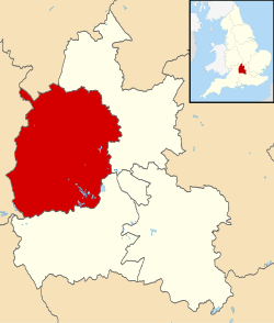
The area is mainly rural downland and forest, with the main economic activities being farming and associated trades. West Oxfordshire lies within the River Thames catchment area, with the Thames itself and its tributaries including the River Evenlode and River Windrush running through the area. [2] Parts of the district suffered severe flooding during the 2007 floods in the UK. [3] Some areas of the district lie within the Cotswolds Area of Outstanding Natural Beauty.

History

West Oxfordshire district was created on 1 April 1974 under the Local Government Act 1972, covering the area of five former districts, which were all abolished at the same time: [4]

The new district was named West Oxfordshire, describing its location within the wider county. [5]

Governance

West Oxfordshire District Council
West Oxfordshire District Council logo.svg
Type
Type
Leadership
Elizabeth Poskitt,
Liberal Democrats
since 22 May 2024 [6]
Andy Graham,
Liberal Democrat
since 18 May 2022 [7]
Giles Hughes
Structure
Seats49 councillors
Oxfordshire West Oxfordshire Council 2024.svg
Political groups
Administration (36)
  Liberal Democrats (21)
  Labour (11)
  Green (4)
Opposition (13)
  Conservative (13)
Elections
Last election
2 May 2024
Next election
7 May 2026
Meeting place
Council offices in Woodgreen - geograph.org.uk - 3610224.jpg
Council Offices, Woodgreen, Witney, OX28 1NB
Website
www.westoxon.gov.uk

Oxfordshire has a two-tier structure of local government, with the five district councils (including West Oxfordshire District Council) providing district-level services, and Oxfordshire County Council providing county-level services. [8] There is also a third tier of local government in West Oxfordshire of civil parishes.

Political control

The council has been under no overall control since the 2022 election. The Liberal Democrats subsequently formed an administration with Labour and the Greens, with Liberal Democrat Andy Graham becoming the leader of the council. [9] The same coalition continued following both the 2023 and 2024 elections. [10]

The first election to the district council was held in 1973, initially operating as a shadow authority alongside the outgoing authorities until it came into its powers on 1 April 1974. Political control of the council since 1974 has been as follows: [11] [12]

Party in controlYears
Independent 1974–1976
No overall control 1976–1983
Conservative 1983–1984
No overall control 1984–1987
Conservative 1987–1990
Independent 1990–1992
No overall control 1992–2000
Conservative 2000–2022
No overall control 2022–present

Leadership

The leaders of the council since 2001 have been: [13]

CouncillorPartyFromTo
Barry Norton [14] Conservative 20018 May 2016
James Mills [15] Conservative 18 May 201628 Oct 2020
Michele Mead [16] Conservative 28 Oct 202018 May 2022
Andy Graham [17] Liberal Democrats 18 May 2022

Composition

Following the 2024 election, the council's political make-up was: [18] [10]

PartyCouncillors
Liberal Democrats 21
Conservative 13
Labour 11
Green 4
Total49

The next election is due in 2026. [19]

Elections

Since the last full review of boundaries in 2002, the council has comprised 49 councillors representing 27 wards. Elections are held in three out of every four years, with one third of the seats on the council being elected at each election. Oxfordshire County Council elections are held in the fourth year of the cycle when there are no district council elections. [20]

Premises

The council is based at the former Witney Rural District Council offices on Woodgreen in Witney. The building was built as a large house in 1887 for one of the town's blanket manufacturers, and was originally known as Springfield, 39 Woodgreen. [21] [22] [23] The building was acquired by Witney Rural District Council around 1966 and is now known as Council Offices, Woodgreen.

Towns and parishes

The whole district is covered by civil parishes. The parishes of Burford, Carterton, Charlbury, Chipping Norton, Witney, and Woodstock have been declared towns and their parish councils therefore take the style 'town council'. [24] Bampton is a post town, but has a parish council rather than a town council. [25]

Related Research Articles

<span class="mw-page-title-main">Witney</span> English town in West Oxfordshire

Witney is a market town on the River Windrush in West Oxfordshire in the county of Oxfordshire, England. It is 12 miles (19 km) west of Oxford.

<span class="mw-page-title-main">Cotswold District</span> Non-metropolitan district in England

Cotswold is a local government district in Gloucestershire, England. It is named after the wider Cotswolds region and range of hills. The council is based in the district's largest town of Cirencester. The district also includes the towns of Chipping Campden, Fairford, Lechlade, Moreton-in-Marsh, Northleach, Stow-on-the-Wold and Tetbury, along with numerous villages and surrounding rural areas.

<span class="mw-page-title-main">Charlbury</span> Town in Oxfordshire, England

Charlbury is a town and civil parish in the Evenlode valley, about 6 miles (10 km) north of Witney in the West Oxfordshire district of Oxfordshire, England. It is on the edge of Wychwood Forest and the Cotswolds. The 2011 Census recorded the parish's population as 2,830.

<span class="mw-page-title-main">Carterton, Oxfordshire</span> Human settlement in England

Carterton is a town in West Oxfordshire district in the county of Oxfordshire, England and is 4 miles (6.4 km) south-west of Witney. The 2011 Census recorded the parish's population as 15,769.

<span class="mw-page-title-main">Chipping Norton</span> Market town in West Oxfordshire, England

Chipping Norton is a market town and civil parish in the Cotswold Hills in the West Oxfordshire district of Oxfordshire, England, about 12 miles (19 km) south-west of Banbury and 18 miles (29 km) north-west of Oxford. The 2011 Census recorded the civil parish population as 5,719. It was estimated at 6,254 in 2019.

<span class="mw-page-title-main">Stagecoach in Oxfordshire</span> Bus and Coach operator

Stagecoach in Oxfordshire is the trading name of Thames Transit Ltd. It is a bus operator serving the county of Oxfordshire, England. Since 1997 has been a subsidiary of Stagecoach Group, and since February 2021 it has been part of Stagecoach West, managed from the latter's headquarters in Gloucester.

<span class="mw-page-title-main">Banbury (UK Parliament constituency)</span> Parliamentary constituency in the United Kingdom, 1801 onwards

Banbury is a constituency in Oxfordshire created in 1553 and represented in the House of Commons of the UK Parliament.

<span class="mw-page-title-main">Witney (UK Parliament constituency)</span> Parliamentary constituency in the United Kingdom since 1983

Witney is a county constituency in Oxfordshire represented in the House of Commons of the Parliament of the United Kingdom since 2024 by Charles Maynard of the Liberal Democrats. It elects one Member of Parliament by the first-past-the-post system of election, and was created for the 1983 general election.

<span class="mw-page-title-main">Brize Norton</span> Human settlement in England

Brize Norton is a village and civil parish 1 mile (1.6 km) east of Carterton in West Oxfordshire. The 2011 Census recorded the parish population as 938. The original part of RAF Brize Norton is in the parish.

<span class="mw-page-title-main">Finstock</span> Human settlement in England

Finstock is a village and civil parish about 2 miles (3 km) south of Charlbury in Oxfordshire, England. The parish is bounded to the northeast by the River Evenlode, to the southeast partly by the course of Akeman Street Roman road, and on other sides by field boundaries. The 2011 Census recorded the parish's population as 797. For most of its history Finstock was a township of the ancient parish of Charlbury. Finstock became a separate civil parish in the late 19th century.

<span class="mw-page-title-main">2013 Oxfordshire County Council election</span> 2013 UK local government election

An election to Oxfordshire County Council took place on 2 May 2013 as part of the 2013 United Kingdom local elections. 63 councillors were elected from 61 electoral divisions, which returned either one or two county councillors each by first-past-the-post voting for a four-year term of office. Following a boundary review, the electoral divisions were not the same as those used at the previous election in 2009. The election saw the Conservative Party lose overall control of the council as the party found itself one seat short of an overall majority.

<span class="mw-page-title-main">2007 West Oxfordshire District Council election</span> 2007 UK local government election

The 2007 West Oxfordshire District Council election took place on 3 May 2007 to elect members of West Oxfordshire District Council in Oxfordshire, England. One third of the council was up for election and the Conservative Party stayed in overall control of the council.

<span class="mw-page-title-main">2011 West Oxfordshire District Council election</span> 2011 UK local government election

The 2011 West Oxfordshire District Council election took place on 5 May 2011 to elect members of West Oxfordshire District Council in Oxfordshire, England. One third of the council was up for election and the Conservative Party stayed in overall control of the council.

<span class="mw-page-title-main">2012 West Oxfordshire District Council election</span> 2012 UK local government election

The 2012 West Oxfordshire District Council election took place on 3 May 2012 to elect members of West Oxfordshire District Council in Oxfordshire, England. One third of the council was up for election and the Conservative Party stayed in overall control of the council.

<span class="mw-page-title-main">2015 West Oxfordshire District Council election</span> 2015 UK local government election

The 2015 West Oxfordshire District Council election took place on 22 May 2015 to elect members of West Oxfordshire District Council in Oxfordshire, England. One third of the council was up for election and the Conservative Party stayed in overall control of the council.

Chipping Norton Rural District was a rural district in Oxfordshire, England from 1894 to 1974. It surrounded but did not include the town of Chipping Norton.

Witney Rural District was a rural district in Oxfordshire, England from 1894 to 1974. It surrounded but did not include the town of Witney.

References

  1. 1 2 UK Census (2021). "2021 Census Area Profile – West Oxfordshire Local Authority (E07000181)". Nomis. Office for National Statistics . Retrieved 5 January 2024.
  2. "West Oxfordshire District Council – Preparing for Flooding".
  3. "Witney Flood Gallery".
  4. "The English Non-metropolitan Districts (Definition) Order 1972", legislation.gov.uk , The National Archives, SI 1972/2039, retrieved 25 April 2023
  5. "The English Non-metropolitan Districts (Names) Order 1973", legislation.gov.uk , The National Archives, SI 1973/551, retrieved 25 April 2023
  6. "Council minutes, 22 May 2024". West Oxfordshire District Council. Retrieved 15 July 2024.
  7. "Council minutes, 18 May 2022" (PDF). West Oxfordshire District Council. Retrieved 25 May 2022.
  8. "Local Government Act 1972", legislation.gov.uk , The National Archives, 1972 c. 70, retrieved 3 March 2023
  9. "Lib Dems set to join forces with Labour and the Greens to take control of West Oxfordshire District Council".
  10. 1 2 Ingham, Jack (14 May 2024). "Lib Dem, Labour and Green groups maintain hold on West Oxfordshire District Council". Banbury Guardian. Retrieved 15 July 2024.
  11. "Compositions calculator". The Elections Centre. Retrieved 19 February 2023.
  12. "West Oxfordshire". BBC News Online . Retrieved 2 August 2015.
  13. "Council minutes". West Oxfordshire District Council. Retrieved 25 April 2023.
  14. Oliver, Matt (5 April 2016). "Council leader Sir Barry Norton to stand down as West Oxfordshire councillor after 43 years". Oxford Mail. Retrieved 25 May 2022.
  15. "Council minutes, 18 May 2016" (PDF). West Oxfordshire District Council. Retrieved 25 May 2022.
  16. "Council minutes, 28 October 2020" (PDF). West Oxfordshire District Council. Retrieved 25 May 2022.
  17. "Council minutes, 18 May 2022" (PDF). West Oxfordshire District Council. Retrieved 25 May 2022.
  18. "West Oxfordshire result – Local Elections 2024". BBC News.
  19. "West Oxfordshire". Local Councils. Thorncliffe. Retrieved 15 July 2024.
  20. "The District of West Oxfordshire (Electoral Changes) Order 2001", legislation.gov.uk , The National Archives, SI 2001/48, retrieved 2 June 2023
  21. "Oxfordshire History Centre Archive Catalogue". Oxfordshire County Council. 11 November 2005. Retrieved 17 March 2022. F17/1/P1/20: 2 postcards of Springfield, Witney, c. 1920, an Early family home, later used by Witney Rural District Council.
  22. 1911 United Kingdom census, Class RG14; Piece 8227; Schedule 158. List address: "Springfield", 39 Woodgreen, Witney.
  23. "Springfield". Witney Blanket Story. Retrieved 17 March 2022.
  24. "Parish / Town Council Elections" (PDF). West Oxfordshire District Council. Retrieved 15 July 2024.
  25. "Bampton Parish Council" . Retrieved 15 July 2024.

51°47′36″N1°28′45″W / 51.79333°N 1.47917°W / 51.79333; -1.47917