Cote, Oxfordshire

Last updated • 5 min readFrom Wikipedia, The Free Encyclopedia

Cote
Cote Baptist Chapel east.JPG
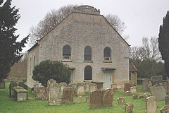
East front of former Baptist chapel
Oxfordshire UK location map.svg
Red pog.svg
Cote
Location within Oxfordshire
OS grid reference SP3502
Civil parish
District
  • West Oxfordshire
Shire county
Region
Country England
Sovereign state United Kingdom
Post town Bampton
Postcode district OX18
Dialling code 01993
Police Thames Valley
Fire Oxfordshire
Ambulance South Central
UK Parliament
Website Aston, Cote, Chimney and Shifford
List of places
UK
England
Oxfordshire
51°43′16″N1°29′24″W / 51.721°N 1.490°W / 51.721; -1.490

Cote is a hamlet about 4 miles (6.4 km) south of Witney and 1 mile (1.6 km) north of the River Thames in West Oxfordshire, England. Cote is part of the civil parish of Aston, Cote, Shifford and Chimney. The hamlet of Cote stretches along Cote Lane, which seems to have originated as a road to a former crossing of the River Thames at Shifford. [1]

Contents

Archaeology

Cropmarks have been found east of Cote Lane that suggest prehistoric occupation. [1] There have been isolated finds of Neolithic and Bronze Age items near the north end of Cote Lane and Iron Age pottery and a brooch have been found south of Cote House. [1] In the 19th century two Roman coins were found at Cote: one each from the reigns of Trajan (reigned AD 98–117) and Hadrian (reigned 117–138). [1] Other cropmarks on river gravel terraces east of Cote suggest Saxon sunken huts. [1]

Manor

In the Anglo-Saxon era Cote was part of the manor of Bampton. [2] The earliest known written record of Cote dates from 1203. [1] Cote may be the site of a messuage and building plot for a manor that Henry III granted to one Imbert Pugeys in 1238. [2] The present Cote House is largely 16th and 17th century but may be on the site of the medieval buildings. [2] The east front of Cote House includes two-light 13th century windows with plate tracery [3] that is not in its original position but may well have been salvaged from the medieval house.

Alan Horde of the Middle Temple bought Cote manor in 1553. [2] The hall range and west wing of Cote House were probably built after 1583 for either Thomas Horde (died circa 1607) or Sir Thomas Horde (died 1662). [2] The west wing and hall still have an early 17th-century staircase and fireplaces and some 17th-century panelling. [2] In 1665 Cote House was assessed at 11 hearths for Hearth Tax. [4] A new main entrance was added to the north front of Cote House in about 1700, presumably for Thomas Horde (died 1715). [2] The principal rooms were refurbished at the same time, [2] including the present panelling of the drawing room. [3] One set of iron gates is dated 1704 [5] and bears the initials of Thomas Horde. [2] Late in the 16th century Thomas Horde was convicted of recusancy and the Crown seized two-thirds of his manor for non-payment of fines. [2] When he died in 1607 his remaining debts were pardoned and the seized part of his manor was restored to his heirs. [2]

Economic and social history

By 1239 Cote and Aston shared a single open field system. [4] Cote Common was often called Cote Moor. [4] In 1497 Mary, Lady Hastings and Botreux, demolished a tenant's house at Cote and enclosed its 20 acres (8.1 ha) landholding as pasture. [4] In the 1660s the Lord of the Manor Thomas Horde enclosed about 120 acres (49 ha) close to Cote House and promoted a general enclosure of the manor, but most tenants enclosed no more than 2 acres (0.81 ha) or 3 acres (1.2 ha) each. [4] The open meadows tended to flood and in 1668 new channels were dug to drain them. [4]

Cote Farmhouse and Cote Cottage were built in the 17th or early in the 18th century. [1] Milton Lodge was rebuilt in about 1720 with a symmetrical five-bayed front. [1] East of Cote is a Windmill Field but no windmill has survived. [4] In 1834 tenants of Aston and Cote sought enclosure and initially Caroline Horde supported them. [4] However, most proprietors did not and the proposal was defeated. [4] Parliament finally passed an Enclosure Act for Aston and Cote in 1852 and the land award was completed in 1855. [4] Most landholdings both before and after enclosure were mixed farms. [4] In the 19th century the Gillett family of Cote House Farm were noted Oxford Down sheep breeders. [4] In 1862 Charles Gillett won prizes at the Royal Agricultural Show. [4]

In the middle of the 19th century a new straight road was built northwards from the end of Cote Lane for a distance of just over 1 mile (1.6 km) to where it joined the road between Yelford and Lew. [1] By 1876 Cote Lodge Farm had been built west of the new road and around the same time new farm labourers' cottages were built. [1] Sir Thomas Horde built a malthouse in 1657 but by 1659 it was making a loss. [4] There is another isolated record of a maltster in Cote in 1725. [4] Cote had a public house, the Black Horse, from 1779 to 1801. [1] In the 1840s Cote House Farm produced cider. [4] The hamlet had a beerhouse from 1869 (when Parliament passed the Wine and Beerhouse Act 1869) but it closed after 1939. [1] Other trades in Cote in 1939 included a hurdle-maker and a saddler. [4] In 1893 Cote suffered a diphtheria epidemic that may have been caused by contaminated wells. [1] Cote had a mains gas supply by 1939, mains electricity by 1949 and mains water from about 1967. [1]

Chapels

Former Baptist chapel from the south-west Cote Baptist Chapel south-west.JPG
Former Baptist chapel from the south-west

Cote has never had a Church of England parish church. Cote was part of the ecclesiastical parish of Bampton, [6] and Cote residents would have worshipped at the chapel of ease at Shifford until it became derelict some time between 1772 and 1784. [7] Cote appointed a warden for Shifford chapel probably in the 15th century and continued to do so for the rebuilt chapel late in the 19th century. [8] A Baptist congregation was established in Cote in about 1656, [5] initially sharing a minister with the Baptist congregation at Longworth on the opposite side of the Thames. [7] Cote's first Baptist chapel was completed and registered for worship in 1704. [7] It was replaced by the present building in 1756, and chapel membership grew from 85 in 1772 to more than 100. [7] In 1850-51 attendance at Sunday morning worship averaged 200.

Benjamin Arthur, who was pastor from 1856 to 1882, had the chapel interior extensively reordered in 1859. [9] The present single gable on the east front of the chapel [5] was added at the same time, replacing a previous double gable and hiding a central roof valley. [7] During Rev. Arthur's ministry, membership rose to about 195 and congregations regularly numbered around 400. [7] For a number of lengthy periods in the 20th century the Baptist congregation lacked a minister and the deacons managed the chapel. [7] Membership declined to 92 in 1906 and 52 in 1935. [7] It had recovered to 104 by 1971 but fell again to about 85 in 1990. [7] The chapel was still in use for worship in 1992 [7] but is now disused. It is a Grade II* listed building and is now managed and maintained by the Historic Chapels Trust. [9]

Related Research Articles

<span class="mw-page-title-main">Bampton, Oxfordshire</span> Human settlement in England

Bampton, also called Bampton-in-the-Bush, is a settlement and civil parish in the Thames Valley about 4+12 miles (7 km) southwest of Witney in Oxfordshire. The parish includes the hamlet of Weald. The 2011 Census recorded the parish's population as 2,564. Bampton is variously referred to as both a town and a village. The Domesday Book recorded that it was a market town by 1086. It continued as such until the 1890s. It has both a town hall and a village hall.

<span class="mw-page-title-main">New Marston</span> Human settlement in England

New Marston is a suburb about 1.25 miles (2 km) northeast of the centre of Oxford, England.

<span class="mw-page-title-main">Standlake</span> Human settlement in England

Standlake is a village and civil parish in West Oxfordshire about 5 miles (8 km) southeast of Witney and 7 miles (11 km) west of Oxford, England. The parish includes the hamlet of Brighthampton. The 2011 Census recorded the parish's population as 1,497. The River Windrush flows past the village and with its tributary Medley Brook it forms much of the eastern boundary of the parish. The western boundary has been subject to changes and disputes in past centuries. It now follows Brighthampton Cut, an artificial land drain dug in the 19th century. The Windrush joins the River Thames at Newbridge just over 1 mile (1.6 km) to the south.

<span class="mw-page-title-main">Yelford</span> Human settlement in England

Yelford is a village and former civil parish, now in the parish of Hardwick-with-Yelford, in the West Oxfordshire district, in the county of Oxfordshire, England. It is about 3 miles (5 km) south of Witney. In 1931 the parish had a population of 17.

<span class="mw-page-title-main">Aston, Oxfordshire</span> Human settlement in England

Aston is a village about 4 miles (6.4 km) south of Witney in West Oxfordshire, England. The village is part of the civil parish of Aston, Cote, Shifford and Chimney. The southern boundary of the parish is the River Thames. The 2011 Census recorded the parish's population as 1,374.
<span class="mw-page-title-main">Chimney, Oxfordshire</span> Human settlement in England

Chimney is a hamlet and former civil parish, now in the parish of Aston, Cote, Shifford and Chimney, in the West Oxfordshire district, in the county of Oxfordshire, England. It is on the River Thames near Shifford Lock, 6 miles (9.7 km) south of Witney. Chimney Meadows 620 acres (250 ha) is the largest nature reserve managed by the Berkshire, Buckinghamshire and Oxfordshire Wildlife Trust.
<span class="mw-page-title-main">Northmoor, Oxfordshire</span> Human settlement in England

Northmoor is a village and civil parish in West Oxfordshire, about 6 miles (10 km) west of Oxford and almost the same distance southeast of Witney. Northmoor is in the valley of the River Thames, which bounds the parish to the east and south, and is close to the River Windrush which forms part of the parish's western boundary. The 2011 Census recorded the parish's population as 377.

<span class="mw-page-title-main">North Leigh</span> Human settlement in England

North Leigh is a village and civil parish about 3 miles (5 km) northeast of Witney in Oxfordshire. The parish includes the hamlet of East End and since 1932 has also included the hamlet of Wilcote. The 2011 Census recorded the parish's population as 1,929.

Brighthampton is a hamlet about 4 miles (6.4 km) south of Witney in West Oxfordshire and contiguous with the village of Standlake.

<span class="mw-page-title-main">Lew, Oxfordshire</span> Human settlement in England

Lew is a village and civil parish about 2+12 miles (4 km) southwest of Witney in the West Oxfordshire District of Oxfordshire, England. The 2001 Census recorded the parish population as 65. Since 2012 the parish has been part of the Curbridge and Lew joint parish council area, sharing a parish council with the adjacent civil parish of Curbridge.

<span class="mw-page-title-main">Shifford</span> Human settlement in England

Shifford is a hamlet in the civil parish of Aston, Cote, Shifford and Chimney in Oxfordshire, England. It is on the north bank of the River Thames about 6 miles (10 km) south of Witney.
<span class="mw-page-title-main">North Aston</span> Human settlement in England

North Aston is a village and civil parish about 7+12 miles (12 km) south of Banbury and 10 miles (16 km) north of Oxford. The 2001 Census recorded its population as 212. The 2011 Census did not publish its population separately, but gave a combined total of 316 for the parishes of North Aston and Middle Aston. The village is on a ridge about 460 feet (140 m) above sea level. The parish measures almost 2 miles (3 km) wide east – west and about 1+12 miles (2.4 km) north – south. It is bounded to the east by the River Cherwell, and to the north by a stream that flows east to join the Cherwell. The A4260 road linking Oxford and Banbury forms part of its western boundary. Field boundaries form the southern boundary and the remainder of the western boundary. In 1983 the parish covered an area of 1,288 acres (521 ha).

<span class="mw-page-title-main">Widford, Oxfordshire</span> Human settlement in England

Widford is a deserted medieval village on the River Windrush about 1.5 miles (2.4 km) east of Burford in West Oxfordshire. The village was an exclave of Gloucestershire until 1844.

<span class="mw-page-title-main">South Leigh</span> Human settlement in England

South Leigh is a village and civil parish on Limb Brook, a small tributary of the River Thames, about 2+12 miles (4 km) east of Witney in Oxfordshire. The 2011 Census recorded the parish's population as 336.
<span class="mw-page-title-main">Hornton</span> Human settlement in England

Hornton is a village and civil parish about 3 miles (5 km) northwest of Banbury in Oxfordshire.

Weald is a hamlet in Bampton civil parish in Oxfordshire, England. It lies about 0.7 miles (1.1 km) southwest of Bampton. The toponym Weald is from the Old English for "woodland". The place was recorded by name in the late 12th century when Osney Abbey acquired a house there. It was a separate township by the 13th century. In the 18th and 19th centuries the township included much of the southwest part of the town of Bampton itself. A large late 17th century manor house, Weald Manor, was remodelled at around 1730. It is a Grade II* listed building.

<span class="mw-page-title-main">Clanfield, Oxfordshire</span> Human settlement in England

Clanfield is a village and civil parish about three miles (5 km) south of Carterton, Oxfordshire. The parish includes the hamlet of Little Clanfield one mile (1.6 km) west of the village, on Little Clanfield Brook which forms the parish's western boundary. The parish's eastern boundary is Black Bourton Brook and its southern boundary is Radcot Cut, an artificial watercourse on the River Thames floodplain. The 2011 Census recorded the parish's population as 879.

<span class="mw-page-title-main">Little Tew</span> Human settlement in England

Little Tew is an English village and civil parish about 4+12 miles (7 km) northeast of Chipping Norton and 8+12 miles (14 km) southwest of Banbury in Oxfordshire. The parish is bounded to the northwest by the River Swere and a road between Little Tew and Hook Norton, to the north by a tributary of the River Cherwell and to the south by an ancient drovers' road called Green Lane. The remaining parts of the parish bounds are field boundaries. The 2011 Census recorded the parish's population as 253.

<span class="mw-page-title-main">Cote Baptist Church</span> Historic site in Oxfordshire, England

Cote Baptist Church stands in Shifford Road, Cote, 1 mile (2 km) to the east of Aston and 4 miles (6 km) to the east of Bampton, in Oxfordshire, England. It is a redundant Baptist chapel in the care of the Historic Chapels Trust, and is recorded in the National Heritage List for England as a designated Grade II* listed building.

<span class="mw-page-title-main">St Mary's Church, Bampton</span> Church in Oxfordshire, England

The Church of Saint Mary the Virgin is the Church of England parish church of Bampton, West Oxfordshire. It is in the Archdeaconry of Dorchester in the Diocese of Oxford.
References

  1. 1 2 3 4 5 6 7 8 9 10 11 12 13 14 A History of the County of Oxford, Volume 13: Bampton Hundred (Part One), Crossley & Currie (eds.), 1996, pages 62-66
  2. 1 2 3 4 5 6 7 8 9 10 11 Crossley & Currie, 1996, pages 66-69
  3. 1 2 Sherwood & Pevsner, 1974, page 558
  4. 1 2 3 4 5 6 7 8 9 10 11 12 13 14 15 16 17 Crossley & Currie, 1996, pages 69-74
  5. 1 2 3 Sherwood & Pevsner, 1974, page 557
  6. Crossley & Currie, 1996, pages 75-76
  7. 1 2 3 4 5 6 7 8 9 10 Crossley & Currie, 1996, pages 77-78
  8. Crossley & Currie, 1996, pages 74-75
  9. 1 2 "Cote Baptist Chapel". Historic Chapels Trust Chapels. Historic Chapels Trust. 2009. Archived from the original on 15 July 2010. Retrieved 25 February 2011.

Sources