Filkins

Last updated • 3 min readFrom Wikipedia, The Free Encyclopedia

Filkins
Formerly The Lamb, Filkins - geograph.org.uk - 1072443.jpg
Formerly The Lamb
Oxfordshire UK location map.svg
Red pog.svg
Filkins
Location within Oxfordshire
OS grid reference SP238041
Civil parish
District
Shire county
Region
Country England
Sovereign state United Kingdom
Post town Lechlade
Postcode district GL7
Dialling code 01367
Police Thames Valley
Fire Oxfordshire
Ambulance South Central
UK Parliament
Website Filkins & Broughton Poggs
List of places
UK
England
Oxfordshire
51°44′10″N1°39′22″W / 51.736°N 1.656°W / 51.736; -1.656

Filkins is a village in the civil parish of Filkins and Broughton Poggs, in the West Oxfordshire district, in the county of Oxfordshire, England. It is about 2.5 miles (4 km) southwest of Carterton.

Contents

Churches

Church of England

The Gothic Revival architect G. E. Street designed the Church of England parish church of Saint Peter, and it was built in 1855–57. [1] The parish is now part of the benefice of Shill Valley and Broadshire.

Methodist

The Methodist chapel was dedicated in 1833. [2]

Local government

Filkins was historically a chapelry in the ancient parish (and civil parish from 1866) of Broadwell. [3] It became a separate civil parish in 1866, [4] on 25 March 1886 the parish was abolished and merged with Broadwell. [5] On 26 March 1894 Filkins became a civil parish again, being formed from part of Broadwell, and was within Witney Rural District. On 1 April 1954 the civil parish was merged with the parish of Broughton Poggs to form the civil parish of Filkins and Broughton Poggs, part of West Oxfordshire since 1974. [6] In 1951 the parish had a population of 371. [7]

Social and economic history

Swinford Museum occupies a 17th-century cottage in Filkins and stands alongside the former village lock-up. George Swinford founded the museum in 1931 with the help of Labour politician and landowner Stafford Cripps.

Stafford Cripps worked with architect Percy Richard Morley Horder and the local stonemason George Swynford on the provision of council housing in the village. Cripps insisted that the new buildings should be of stone and stylistically in keeping with local vernacular traditions, meeting the difference in cost for the council housing, re-opening quarries on his own land to provide building. This was recorded in Country Life . As a result, by 1944 Filkins was being hailed as 'a modernised village' and 'an illustration of contemporary village planning', in an article in Country Life by Christopher Hussey. [8]

In 2007 the Filkins estate, which John Cripps (son of the post-war Labour minister Stafford Cripps) bequeathed upon his death in 1993, but which had been partly passed over to the Ernest Cook Trust [9] since then, was fully transferred to the Trust's portfolio. The Filkins Estate is on the county boundary between Gloucestershire and Oxfordshire and includes one 500 acres (200 ha) farm and a number of cottages, with a small area of commercial units housing the Cotswold Woollen Weavers and Filkins Stone Company.

Amenities

Filkins has a public house, the Five Alls. [10] The village has an outdoor swimming pool owned by the Centre Trust which was established by Sir Stafford Cripps under the control of the parish council (acting as trustees). The pool, now managed by the Filkins Swimming Club, is open from May until September.[ citation needed ] Next to it are the village shop, post office and bowls club. A large 18th-century barn is now the premises of Cotswold Woollen Weavers, which set up business there in 1982, and is the last company in the area to uphold the traditions of woollen cloth design and manufacture. [11] Filkins has a theatre club.[ citation needed ] The former village school is now a pre-school nursery. [12]

Related Research Articles

<span class="mw-page-title-main">Eynsham</span> Village in Oxfordshire, England

Eynsham is a village and civil parish in the West Oxfordshire district, in Oxfordshire, England, about 5 miles (8 km) north-west of Oxford and east of Witney. The 2011 Census recorded a parish population of 4,648. It was estimated at 5,087 in 2020.

<span class="mw-page-title-main">Kelmscott</span> Village in Oxfordshire, England

Kelmscott is a village and civil parish on the River Thames in West Oxfordshire, about 2 miles (3 km) east of Lechlade in neighbouring Gloucestershire. Since 2001 it has absorbed Little Faringdon, which had been a separate civil parish. The 2011 Census recorded the merged parish's population as 198.

<span class="mw-page-title-main">River Windrush</span> River in England

The River Windrush is a tributary of the River Thames in central England. It rises near Snowshill in Gloucestershire and flows south east for 65 km (40 mi) via Burford and Witney to meet the Thames at Newbridge in Oxfordshire.

<span class="mw-page-title-main">Bampton, Oxfordshire</span> Civil parish in Oxfordshire, England

Bampton, also called Bampton-in-the-Bush, is a settlement and civil parish in the Thames Valley about 4+12 miles (7 km) southwest of Witney in Oxfordshire. The parish includes the hamlet of Weald. The 2011 Census recorded the parish's population as 2,564. Bampton is variously referred to as both a town and a village. The Domesday Book recorded that it was a market town by 1086. It continued as such until the 1890s. It has both a town hall and a village hall.

<span class="mw-page-title-main">Broadwell, Oxfordshire</span> Human settlement in England

Broadwell is a village and civil parish about 2 miles (3 km) south-west of Carterton in West Oxfordshire. The 2011 Census recorded the parish's population as 218.

<span class="mw-page-title-main">Swinbrook</span> Village in Oxfordshire, England

Swinbrook is a village and former civil parish, now in the parish of Swinbrook and Widford, in the West Oxfordshire district, in the county of Oxfordshire, England. It is on the River Windrush, about 2 miles (3 km) east of Burford. Widford is a hamlet about 0.5 miles (800 m) west of Swinbrook. The 2011 Census recorded the population of Swinbrook and Widford as 139.

<span class="mw-page-title-main">Cogges</span> Place in Oxfordshire, England

Cogges is an area beside the River Windrush in Witney, in the West Oxfordshire district, in Oxfordshire, England, 0.5 miles (800 m) east of the town centre. It had been a separate village and until 1932 it was a separate civil parish.

<span class="mw-page-title-main">Broughton Poggs</span> Village in Oxfordshire, England

Broughton Poggs is a village in the civil parish of Filkins and Broughton Poggs, in the West Oxfordshire district, in the county of Oxfordshire, England. Broughton Poggs is 3 miles (5 km) southwest of Carterton.

<span class="mw-page-title-main">Langford, Oxfordshire</span> Village in Oxfordshire, England

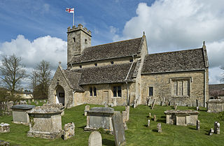
Langford is a village and civil parish in West Oxfordshire, about 3 miles (5 km) northeast of Lechlade in neighbouring Gloucestershire. The 2011 Census recorded the parish's population as 349.

<span class="mw-page-title-main">Widford, Oxfordshire</span> Deserted village in Oxfordshire, England

Widford is a deserted medieval village in the civil parish of Swinbrook and Widford, in the West Oxfordshire district, in the county of Oxfordshire, England. It is on the River Windrush about 1.5 miles (2.4 km) east of Burford. The village was an exclave of Gloucestershire until 1844.

<span class="mw-page-title-main">Little Faringdon</span> Village in Oxfordshire, England

Little Faringdon is a village and civil parish in West Oxfordshire, about 1 mile (1.6 km) north of Lechlade in neighbouring Gloucestershire. The 2001 Census recorded its population as 63.

<span class="mw-page-title-main">Clanfield, Oxfordshire</span> Human settlement in England

Clanfield is a village and civil parish about three miles (5 km) south of Carterton, Oxfordshire. The parish includes the hamlet of Little Clanfield one mile (1.6 km) west of the village, on Little Clanfield Brook which forms the parish's western boundary. The parish's eastern boundary is Black Bourton Brook and its southern boundary is Radcot Cut, an artificial watercourse on the River Thames floodplain. The 2011 Census recorded the parish's population as 879.

<span class="mw-page-title-main">Hailey, Oxfordshire</span> Village in England

Hailey is a village and civil parish about 2 miles (3 km) north of Witney, Oxfordshire. The village comprises three neighbourhoods: Middletown on the main road between Witney and Charlbury, Poffley End on the minor road to Ramsden and Delly End on Whiting's Lane. The parish extends from the River Windrush in the south, almost to the village of Ramsden and the hamlet of Wilcote in the north, and it includes the hamlet of New Yatt. The 2011 Census recorded the parish's population as 1,208.

<span class="mw-page-title-main">Holwell, Oxfordshire</span> Village in Oxfordshire, England

Holwell is a village and civil parish about 2 miles (3 km) south of Burford in West Oxfordshire. The 2001 Census recorded the parish's population as 17.

<span class="mw-page-title-main">Westwell, Oxfordshire</span> Village in Oxfordshire, England

Westwell is a small village and civil parish about 2 miles (3 km) southwest of the market town of Burford in Oxfordshire. It is the westernmost village in the county, close to the border with Gloucestershire.

Richard Pace was a Georgian builder and architect in Lechlade, Gloucestershire, England. He served in the Life Guards 1784–88. Most of his known commissions were houses, in many cases for Church of England clergy. He also restored or refitted a small number of Church of England parish churches. He is commemorated by a monument in St. Lawrence's parish churchyard, Lechlade.

Filkins and Broughton Poggs is a civil parish in West Oxfordshire, on the Oxfordshire county boundary with Gloucestershire. The parish includes the villages of Filkins and Broughton Poggs, which were separate civil parishes until they were merged in 1954. The population in the 2011 Census was 434.

<span class="mw-page-title-main">St Matthew's Church, Langford</span> Church in Oxfordshire , United Kingdom

The Parish Church of Saint Matthew, Langford is the Church of England parish church of Langford, a village in West Oxfordshire about 3 miles (5 km) northeast of Lechlade in neighbouring Gloucestershire.

The Swinford Museum is a small museum in the village of Filkins, west Oxfordshire, England.

<span class="mw-page-title-main">Evenlode</span> Human settlement in England

Evenlode is a village and civil parish in the Cotswold District of eastern Gloucestershire in England.

References

  1. Sherwood & Pevsner 1974, p. 604.
  2. "Filkins Methodist chapel". Filkins & Broughton Poggs.
  3. "History of Filkins in West Oxfordshire". A Vision of Britain through Time . Retrieved 5 April 2024.
  4. "Relationships and changes Filkins Hmlt/CP through time". A Vision of Britain through Time. Retrieved 5 April 2024.
  5. "Witney Registration District". UKBMD. Retrieved 5 April 2024.
  6. Vision of Britain website
  7. "Population statistics Filkins CP through time". A Vision of Britain through Time. Retrieved 5 April 2024.
  8. C. Hussey, 'Filkins, Gloucestershire: a Modernised Village', Country Life, 28 April 1944, pp. 728–31;
  9. "The Filkins Estate and the Ernest Cook Trust". Archived from the original on 19 July 2011. Retrieved 8 January 2010.
  10. The Five Alls
  11. Cotswold Woollen Weavers
  12. The Old Station Nursery Archived 10 September 2009 at the Wayback Machine

Sources and further reading

Commons-logo.svg Media related to Filkins at Wikimedia Commons