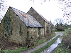
Playhatch is a hamlet in the civil parish of Eye & Dunsden in South Oxfordshire, England, about 2 miles (3.2 km) northeast of Reading, Berkshire.

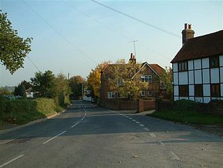
Goring Heath is a hamlet and civil parish in the Chiltern Hills in South Oxfordshire. The civil parish includes the villages of Whitchurch Hill and Crays Pond and some small hamlets. Goring Heath is centred 3 miles (4.8 km) southeast of Goring-on-Thames and about 4 miles (6.4 km) northwest of Reading, Berkshire. In 1724 Henry Alnutt, a lawyer of the Middle Temple in London, established a set of almshouses at Goring Heath. They form three sides of a courtyard, flanking a chapel of the same date. In the 1880s a school was built beside the almshouses in what was intended to be the same architectural style. A post office was added in 1900.
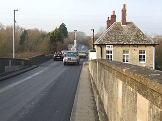
Swinford in the English county of Oxfordshire is a hamlet in the civil parish of Cumnor. It lies on the road between Eynsham and Farmoor (B4044) on the south bank of the River Thames. The Swinford Toll Bridge carrying the B4044 crosses the River Thames here. In 1974 it was transferred from Berkshire to the county of Oxfordshire.
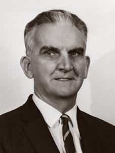
Kenneth Ewart Boulding was an English-born American economist, educator, peace activist, and interdisciplinary philosopher. Boulding was the author of two citation classics: The Image: Knowledge in Life and Society (1956) and Conflict and Defense: A General Theory (1962). He was co-founder of general systems theory and founder of numerous ongoing intellectual projects in economics and social science. He was married to sociologist Elise M. Boulding.

Christmas Common is a hamlet in Watlington civil parish, Oxfordshire about 7+1⁄2 miles (12 km) south of Thame in Oxfordshire, close to the boundary with Buckinghamshire. The hamlet is 812 feet (247 m) above sea level on an escarpment of the Chiltern Hills. Because of its elevation, Christmas Common has two radio masts that are prominent local landmarks.

Barnard Gate is a hamlet in the civil parish of Eynsham, in the West Oxfordshire district, in Oxfordshire, England, about 3 miles (4.8 km) east of Witney. It has a public house, the Boot Inn.

Idbury is a village and civil parish in the Cotswold Hills in Oxfordshire, about 4+1⁄2 miles (7 km) southeast of Stow-on-the-Wold in neighbouring Gloucestershire. The parish includes the hamlets of Bould and Foscot. The 2011 Census recorded the parish's population as 240.
Moreton is a hamlet 1 mile (1.6 km) southwest of Thame in Oxfordshire, England.
Swinbrook and Widford is a civil parish in West Oxfordshire district, in the county of Oxfordshire, England. It comprises the village of Swinbrook and the hamlet of Widford. The 2001 census recorded its population as 139.

Fulwell is a hamlet in the civil parish of Enstone in Oxfordshire, England. It lies about 4.5 miles (7 km) southeast of Chipping Norton. Fulwell's toponym is derived from its "foul well". The hamlet was part of the manor of Spelsbury in the ancient parish and later civil parish of Spelsbury. In 1985 Fulwell was transferred to the civil parish of Enstone.

Denton is a hamlet and former civil parish, now in the parish of Cuddesdon and Denton, in the South Oxfordshire district, in Oxfordshire, England. Denton's toponym is derived from the Old English den-tun meaning "valley farmstead". Denton is in a fold of the landscape, between the two hills on which Cuddesdon and Garsington stand. Denton is an ancient manor and had its own civil parish, but it was merged with neighbouring Cuddesdon in the 20th century.

Swyncombe is a hamlet and large civil parish in the high Chilterns, within the Area of Outstanding Natural Beauty about 4+1⁄2 miles (7 km) east of Wallingford, Oxfordshire, England. Swyncombe hamlet consists almost entirely of its Church of England parish church of Saint Botolph, the former rectory and Swyncombe House. The population of the parish is in the hamlets of Cookley Green and Russell's Water, and the scattered hamlet of Park Corner. The 2011 Census recorded the parish's population as 250. It is partially forested and is the fifth largest of 87 civil parishes in the District.
Foscot is a hamlet in the Cotswolds in the Evenlode valley. It falls within Idbury civil parish, in the West Oxfordshire District, about 5 miles (8.0 km) southeast of Stow-on-the-Wold in neighbouring Gloucestershire, and 1.7 miles (2.7 km) from Kingham. It is in a designated Area of Outstanding Natural Beauty. Foscot is in the ecclesiastical parish of St Leonard, Bledington and is socially integrated with the adjacent Bledington village. The major landowner is Loudham Estates, based at Foxcote Farm. Foxholes, a woodland nature reserve sloping down to the River Evenlode with year-round colour and wildlife interest, is adjacent to Foscot. It is noted for its spring bluebells and abundant bat and bird life and is managed by the Berkshire, Buckinghamshire and Oxfordshire Wildlife Trust.

Grafton is a hamlet and former civil parish, now in the parish of Grafton and Radcot, in the West Oxfordshire district, in the county of Oxfordshire, England. It is in the Thames Valley, about 3+1⁄2 miles (5.6 km) north of Faringdon. Grafton Lock is on the River Thames about 1 mile (1.6 km) south of the hamlet. In 1931 the parish had a population of 54.

Gagingwell is a hamlet in West Oxfordshire, about 6 miles (10 km) east of Chipping Norton and about 1.8 miles (3 km) east of Enstone. The hamlet surrounds a group of springs that give rise to a brook, which flows southwards almost 1 mile (1.6 km) to join the River Glyme just downstream of the hamlet of Radford.

Ardington and Lockinge are two civil parishes in the Vale of White Horse district, centred about 2 miles (3 km) east of Wantage, Oxfordshire, that share a single parish council. The two parishes were part of Berkshire until 1974 when they were transferred to Oxfordshire.

Bould Wood is a 58.2-hectare (144-acre) biological Site of Special Scientific Interest north of Shipton-under-Wychwood in Oxfordshire. An area of 23 hectares is Foxholes nature reserve, which is managed by the Berkshire, Buckinghamshire and Oxfordshire Wildlife Trust.