Little Tew

Last updated

Little Tew
Little Tew (Oxon) St John the Evangelist's Church - geograph.org.uk - 69740.jpg
St John the Evangelist parish church
Oxfordshire UK location map.svg
Red pog.svg
Little Tew
Location within Oxfordshire
Population253 (2011 Census)
OS grid reference SP3828
Civil parish
  • Little Tew
District
Shire county
Region
Country England
Sovereign state United Kingdom
Post town Chipping Norton
Postcode district OX7
Dialling code 01608
Police Thames Valley
Fire Oxfordshire
Ambulance South Central
UK Parliament
Website Little Tew
List of places
UK
England
Oxfordshire
51°57′22″N1°26′31″W / 51.956°N 1.442°W / 51.956; -1.442

Little Tew is an English village and civil parish about 4+12 miles (7 km) northeast of Chipping Norton and 8+12 miles (14 km) southwest of Banbury in Oxfordshire. The parish is bounded to the northwest by the River Swere and a road between Little Tew and Hook Norton, to the north by a tributary of the River Cherwell and to the south by an ancient drovers' road called Green Lane. The remaining parts of the parish bounds are field boundaries. [1] The 2011 Census recorded the parish's population as 253. [2]

Contents

Manor

Before the Norman conquest of England, Leofwine of Barton held the manor of Little Tew along with those of Dunthrop, Duns Tew and Westcott Barton. [3] The Domesday Book records that in 1086 Odo, Bishop of Bayeux held Little Tew. The manor was divided between three tenants: Wadard and Humphrey each had three and a half hides and Ilbert de Lacy had two hides. On or before Odo's death in 1097 the tenants succeeded Odo as tenants-in-chief, thus dividing Little Tew into three separate manors. [1] Wadard's lands were the beginnings of the barony of Arsic. In 1103 Manasser Arsic founded a priory of the Benedictine Abbey of Fécamp at Cogges and gave the priory an endowment including the Wadard manor at Little Tew. In 1441 Henry VI seized the priory and its estates and gave them to Eton College, which sold most of its land at Little Tew in 1921. [1]

In 1206 Osney Abbey acquired the Humphrey manor. In 1542 The Abbey was suppressed in the Dissolution of the Monasteries but its manor at Little Tew was granted to the new Oxford Cathedral, which was Osney's former abbey church. However, in 1545 the seat of the Diocese of Oxford was transferred from the former Osney Abbey to the former St. Frideswide's Priory and the manor at Little Tew was returned to the Crown. In 1565 the Crown gave the manor to Sir William Petre, who in 1566 gave it to Exeter College, Oxford. [1] The de Lacy manor at Little Tew became part of the Honour of Pontefract, in which it remained until Alice de Lacy died in 1348. By 1356 the manor was attached to the barony of Clifford Castle in Herefordshire. [1]

Church and chapel

There is a tradition that Little Tew had a medieval chapel before the English Reformation, but no physical or definite documentary evidence is known to prove this. When the parish's common lands were enclosed in 1794, 16+12 acres (6.7 ha) of land were set aside for an income to fund church services but no church was built. [1] The first report of Baptists in Little Tew is from 1771 and one villager registered his house as an Anabaptist meeting place in 1778.

In 1829 a Baptist missionary from Chipping Norton applied for a licence to convert a building in Little Tew into a chapel, and Baptist services in Little Tew attracted about 100 people from the surrounding area. Exeter College offered to build and endow an Anglican church for Little Tew "to prevent alienation of the inhabitants from the Established Church". [1] The Vicar of Great Tew did not support the idea but his successors held Anglican services in Little Tew, at first in a barn and later in the new village school that was built in 1836. [1]

In 1845 the Baptists finally built a small chapel [1] and in 1853 the Church of England completed the chapel of Saint John the Evangelist, designed by the Gothic Revival architect G.E. Street in an early-14th-century style. [4] It has a tower with a gabled roof [5] and a chime of eight bells. [6] St. John's was a chapel of ease of the parish of Great Tew until 1857, when Little Tew was made a separate ecclesiastical parish. [1] Today St. John's is once again part of a single benefice with the parish of Great Tew. [6]

Street also designed the vicarage, completed in the same year as St. John's chapel. [7] The vicarage was altered and enlarged firstly by Charles Buckeridge in about 1869 and then by E.G. Bruton in 1880. [7] The Baptist chapel was rebuilt in 1871, with a stepped gable and Perpendicular Gothic style windows. [4] A schoolroom was added in 1925 but both it and the chapel were sold in 1968. [1] The building is now in private use. [5]

Economic and social history

In the 13th century Little Tew had a windmill in South Field. It may have been on the same site as a windmill recorded near Lodge Farm in 1742, south of the village on the road to Church Enstone. The mill seems to have disappeared by 1767. [1] The oldest building in the parish is the shell of a 14th-century house. [7] It was extended in the 16th century and is now internally reordered as two cottages but it retains its medieval screens passage. [7] In 1767 the enclosure of common lands at Great Tew deprived Little Tew of some grazing land. Little Tew continued to farm under an open field system until an Act of Parliament enabled its lands to be enclosed in 1794. [1]

A day school was founded in Little Tew in 1823. Exeter College supported it from 1830 and Eton College supported it from 1834. Exeter College also gave land on which a schoolhouse and master's house were built in 1836. [1] In 1862–63 a new schoolhouse and master's house and set of three almshouses were built, all designed by Charles Buckeridge. [7] The almshouses were never used as such but were sold for private use. The 1836 school building was converted into a house in 1867 and let to provide income for the school. In the 1900s the number of school pupils declined and in 1923 the school was closed. [1] Little Tew had a post office from 1881 until about 1975. [1] The Bell House was a public house but is now a private house. [1] For forty years, until 2009, the Grange became home for an amateur theatre of high repute.

Related Research Articles

<span class="mw-page-title-main">Chadlington</span> Human settlement in England

Chadlington is a village and civil parish in the Evenlode Valley about 3 miles (5 km) south of Chipping Norton, Oxfordshire. The village has four neighbourhoods: Brookend, Eastend, Greenend and Westend.

<span class="mw-page-title-main">Enstone</span> Village and civil parish in Oxfordshire, England

Enstone is a village and civil parish in England, about 4 miles (6.4 km) east of Chipping Norton and 15 miles (24 km) north-west of Oxford city. The civil parish, one of Oxfordshire's largest, consists of the villages of Church Enstone and Neat Enstone, with the hamlets of Chalford, Cleveley, Fulwell, Gagingwell, Lidstone and Radford. The 2011 Census put the parish population as 1,139 living in 453 households. It was estimated at 1,256 in 2019.

Cogges is an area beside the River Windrush in Witney, Oxfordshire, 0.5 miles (800 m) east of the town centre. It had been a separate village and until 1932 it was a separate civil parish.

<span class="mw-page-title-main">Stanton Harcourt</span> Human settlement in England

Stanton Harcourt is a village and civil parish in Oxfordshire about 4 miles (6.4 km) southeast of Witney and about 6 miles (10 km) west of Oxford. The parish includes the hamlet of Sutton, 12 mile (800 m) north of the village. The 2011 Census recorded the parish's population as 960.

<span class="mw-page-title-main">Cassington</span> Human settlement in England

Cassington is a village and civil parish in Oxfordshire about 5 miles (8 km) northwest of Oxford. The village lies on gravel strata about 12 mile (800 m) from the confluence of the River Evenlode with the River Thames. The parish includes the hamlet of Worton northeast of the village and the site of the former hamlet of Somerford to the south. Somerford seems to have been abandoned early in the 14th century. Cassington is formed of two parts, "upper" and "lower", each with its own village green. The 2011 Census recorded the parish's population as 750.

<span class="mw-page-title-main">Shipton-on-Cherwell</span> Human settlement in England

Shipton-on-Cherwell is a village on the River Cherwell about 2 miles (3 km) north of Kidlington in Oxfordshire, England. The village is part of the civil parish of Shipton-on-Cherwell and Thrupp.

<span class="mw-page-title-main">North Leigh</span> Human settlement in England

North Leigh is a village and civil parish about 3 miles (5 km) northeast of Witney in Oxfordshire. The parish includes the hamlet of East End and since 1932 has also included the hamlet of Wilcote. The 2011 Census recorded the parish's population as 1,929.

<span class="mw-page-title-main">Duns Tew</span> Human settlement in England

Duns Tew is an English village and civil parish about 7+12 miles (12 km) south of Banbury in Oxfordshire. The 2011 Census recorded the parish's population as 478. With nearby Great Tew and Little Tew, Duns Tew is one of the three villages known collectively as "The Tews". A 'tew' is believed to be an ancient term for a ridge of land.

Brighthampton is a hamlet about 4 miles (6.4 km) south of Witney in West Oxfordshire and contiguous with the village of Standlake.

<span class="mw-page-title-main">Heythrop</span> Human settlement in England

Heythrop is a village and civil parish just over 2 miles (3 km) east of Chipping Norton, Oxfordshire. The parish includes the hamlet of Dunthrop. The 2001 Census recorded the parish population as 93.

<span class="mw-page-title-main">Great Tew</span> Village in Oxfordshire, England

Great Tew is an English village and civil parish in Oxfordshire, about 5 miles (8 km) north-east of Chipping Norton and 8 miles (13 km) south-west of Banbury. The 2011 Census gave a parish population of 156. This qualifies it for an annual parish meeting, not a monthly parish council. The village has largely belonged since the 1980s to the Johnston family, as the Great Tew Estate, with renovations and improvements.

<span class="mw-page-title-main">South Newington</span> Human settlement in England

South Newington is a village and civil parish on the south bank of the River Swere in the Cotswold Hills in Oxfordshire, England, about 5 miles (8 km) southwest of Banbury. The 2011 Census recorded the parish's population as 285.

<span class="mw-page-title-main">Widford, Oxfordshire</span> Human settlement in England

Widford is a deserted medieval village on the River Windrush about 1.5 miles (2.4 km) east of Burford in West Oxfordshire. The village was an exclave of Gloucestershire until 1844.

<span class="mw-page-title-main">Forest Hill, Oxfordshire</span> Human settlement in England

Forest Hill is a village in the civil parish of Forest Hill with Shotover, in the South Oxfordshire district, in Oxfordshire, England, about 4.5 miles (7 km) east of Oxford. The village which is about 330 feet (100 m) above sea level is on the northeastern brow of a ridge of hills. The highest point of the ridge is Red Hill, which rises to 440 feet (130 m) just south of the village. The 2011 Census recorded Forest Hill with Shotover's population as 856.

<span class="mw-page-title-main">Charles Buckeridge</span> British architect (c. 1832–1873)

Charles Buckeridge was a British Gothic Revival architect who trained as a pupil of Sir George Gilbert Scott. He practised in Oxford 1856–68 and in London from 1869. He was made an Associate of the Royal Institute of British Architects in 1861.

<span class="mw-page-title-main">William Wilkinson (architect)</span> British architect (1819–1901)

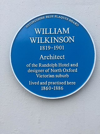
William Wilkinson (1819–1901) was a British Gothic Revival architect who practised in Oxford, England.

<span class="mw-page-title-main">Steeple Barton</span> Human settlement in England

Steeple Barton is a civil parish and scattered settlement on the River Dorn in West Oxfordshire, about 8+12 miles (13.7 km) east of Chipping Norton, a similar distance west of Bicester and 9 miles (14 km) south of Banbury. Most of the parish's population lives in the village of Middle Barton, about 1 mile (1.6 km) northwest of the settlement of Steeple Barton. The 2011 Census recorded the parish's population as 1,523. Much of the parish's eastern boundary is formed by the former turnpike between Oxford and Banbury, now classified the A4260 road. The minor road between Middle Barton and Kiddington forms part of the western boundary. Field boundaries form most of the rest of the boundaries of the parish.

<span class="mw-page-title-main">Westcott Barton</span> Human settlement in England

Westcott Barton, also spelt Wescot Barton or Wescote Barton, is a village and civil parish on the River Dorn in West Oxfordshire about 7 miles (11 km) east of Chipping Norton and about 9+12 miles (15 km) south of Banbury, in the county of Oxfordshire, England. The parish is bounded to the north by Cockley Brook, a tributary of the River Dorn. A minor road to Kiddington forms part of the eastern boundary, another minor road forms part of the western boundary and the remainder of the parish boundaries are field boundaries. Westcott Barton's main area of housing is on the eastern boundary of the parish and contiguous with the village of Middle Barton in the neighbouring parish of Steeple Barton. The 2011 Census recorded the parish's population as 244.

<span class="mw-page-title-main">Nether Worton</span> Human settlement in England

Nether Worton is a hamlet in the civil parish of Worton, in the West Oxfordshire district, in the county of Oxfordshire, England. It is about 6+12 miles (10.5 km) south of Banbury and 7 miles (11 km) east of Chipping Norton. In 1931 the parish had a population of 42. On 1 April 1932 the parish was abolished and merged with Over Worton to form "Worton".

<span class="mw-page-title-main">Over Worton</span> Human settlement in England

Over Worton is a hamlet in the civil parish of Worton, in the West Oxfordshire district, in the county of Oxfordshire, England, about 7 miles (11 km) south of Banbury and 7+12 miles (12 km) east of Chipping Norton. In 1931 the parish had a population of 72. On 1 April 1932 the parish was abolished and merged with Nether Worton to form "Worton".

References

  1. 1 2 3 4 5 6 7 8 9 10 11 12 13 14 15 16 17 Crossley 1983 , pp. 247–258
  2. "Area: Little Tew (Parish): Key Figures for 2011 Census: Key Statistics". Neighbourhood Statistics . Office for National Statistics . Retrieved 7 August 2015.
  3. Crossley 1983, pp. 75–81.
  4. 1 2 Sherwood & Pevsner 1974, p. 690.
  5. 1 2 Oxfordshire Churches & Chapels: Little Tew Archived 1 December 2009 at the Wayback Machine
  6. 1 2 Archbishops' Council. "Little Tew: St John the Evangelist, Little Tew". A Church Near You. Church of England.
  7. 1 2 3 4 5 Sherwood & Pevsner 1974, p. 691.

Sources and further reading