Duns Tew

Last updated

Duns Tew
DunsTew StMaryMagdalene south.JPG
St Mary Magdalene parish church
Oxfordshire UK location map.svg
Red pog.svg
Duns Tew
Location within Oxfordshire
Area7.07 km2 (2.73 sq mi)
Population478 (2011 Census)
  Density 68/km2 (180/sq mi)
OS grid reference SP4528
District
Shire county
Region
Country England
Sovereign state United Kingdom
Post town Bicester
Postcode district OX25
Dialling code 01869
Police Thames Valley
Fire Oxfordshire
Ambulance South Central
UK Parliament
Website Duns Tew Oxfordshire
List of places
UK
England
Oxfordshire
51°57′14″N1°20′10″W / 51.954°N 01.336°W / 51.954; -01.336

Duns Tew is an English village and civil parish about 7+12 miles (12 km) south of Banbury in Oxfordshire. The 2011 Census recorded the parish's population as 478. [1] With nearby Great Tew and Little Tew, Duns Tew is one of the three villages known collectively as "The Tews". A 'tew' is believed to be an ancient term for a ridge of land.

Contents

Manor

Before the Norman conquest of England, Leofwine of Barton held the manor of Duns Tew along with those of Dunthrop, Little Tew and Westcott Barton. [2] The Domesday Book of 1086 records four estates in the parish, of which the two largest belonged to Robert D'Oyly and Robert de Stafford. [3] In addition, Gilbert de Magminot, Bishop of Lisieux held an estate of three hides and Odo, Bishop of Bayeux and half-brother of William I held an estate of one hide. [3] The present manor house contains 17th-century remnants and a wing added in the 19th century, but the main part of the present house is 18th-century. [4] The house has a 17th-century dovecote. [4] Priory Court, a 19th-century house east of the church, used to be the vicarage. [5]

Church and chapel

Church of England

The Church of England parish church of St Mary Magdalene existed in the 12th century, from which period the font and one Early English Gothic lancet window in the chancel survive. [3] The north aisle was added late in the 13th or early in the 14th century. [3] The tower, south porch and many of the present windows were added late in the 14th or early in the 15th century. [3] The tower collapsed in 1647, damaging the south side of the church. [3] It was rebuilt in 1664–65. [3] In 1861–62 Sir George Gilbert Scott completely rebuilt the chancel and north aisle and partly rebuilt the south wall of the nave. [3]

The tower has a ring of five bells. [6] Richard Keene of Woodstock [7] cast the second bell in 1668 [6] and the third bell in 1694. [6] Matthew III Bagley of Chacombe, [7] Northamptonshire cast the tenor bell in 1768. Robert II Wells of Aldbourne, [7] Wiltshire cast the treble bell in 1790. [6] Charles and George Mears of the Whitechapel Bell Foundry cast the fourth bell in 1858. [6] St Mary Magdalene's has also a Sanctus bell that Thomas II Mears of Whitechapel cast in 1828. [6] In 1977 the parishes of Duns Tew and Sandford St. Martin were merged with the Benefice of Westcott Barton and Steeple Barton. [3] In March 2015 the benefice was merged with that of Over Worton and Nether Worton to form the Benefice of Westcote Barton with Steeple Barton, Duns Tew and Sandford St Martin and Over with Nether Worton, [8] also called the Barton Benefice. [9]

Baptist

A Baptist chapel was completed in 1809. [3]

Economic and social history

The Ridge House, opposite the parish church, was built in the first half of the 17th century Duns Tew thatched cottage.jpg
The Ridge House, opposite the parish church, was built in the first half of the 17th century

The parish had a watermill by 1279. [3] It was still recorded in 1618 but seems to have disappeared by 1722. [3] In 1650 Anne Greene, a domestic servant at Duns Tew manor house, was convicted of the infanticide of her stillborn child. [10] She was hanged at Oxford Castle but survived after being presumed dead and was given a free pardon. [10] Most of the parish was farmed under two separate open field systems until 1794, when the common lands were enclosed. [3]

A Sunday School for the parish was founded in 1798 and a day school had been added by 1808. [3] By 1818 the Sunday school had been converted to the National School system. [3] Sir George Dashwood provided and equipped a school building in 1830. [3] The school outgrew its building and in 1874 new premises were completed with capacity for 100 children. [3] In 1928 it was reorganised as a junior school, with senior pupils going to the school at Steeple Aston. [3] The number of pupils declined and in 1969 Duns Tew school was closed. [3] Since 1970 the building has served as Duns Tew village hall. [3] On the 23rd of February 1976 BBC Nationwide ran a feature on the workshop of luthier David Rubio at the Ridgehouse. [11]

Amenities

Sketch of the parish church from the southeast in 1822, showing the Perpendicular Gothic east window that it had until the church was rebuilt in 1861 DunsTew StMaryMagdalene 1822.JPG
Sketch of the parish church from the southeast in 1822, showing the Perpendicular Gothic east window that it had until the church was rebuilt in 1861
Undated engraving of the parish church from the south, possibly 18th century, showing its appearance before its Victorian restoration DunsTew StMaryMagdalene Old.JPG
Undated engraving of the parish church from the south, possibly 18th century, showing its appearance before its Victorian restoration

Although there are no shops, Duns Tew has a public house, the White Horse. [12] Duns Tew has a Community Action Group. [13]

Related Research Articles

<span class="mw-page-title-main">Woodstock, Oxfordshire</span> Human settlement in England

Woodstock is a market town and civil parish, 8 miles (13 km) north-west of Oxford in West Oxfordshire in the county of Oxfordshire, England. The 2011 Census recorded a parish population of 3,100.

<span class="mw-page-title-main">Steeple Aston</span> Human settlement in England

Steeple Aston is a village and civil parish on the edge of the Cherwell Valley, in the Cherwell District of Oxfordshire, England, about 12 miles (19 km) north of Oxford, 7 miles (11 km) west of Bicester, and 10 miles (16 km) south of Banbury. The 2011 Census recorded the parish population as 947. The village is 108 metres (354 ft) above sea level. The River Cherwell and Oxford Canal pass 1 mile (2 km) east of the village. The river forms part of the eastern boundary of the parish. The parish's southern boundary, 12 mile (800 m) south of the village, also forms part of Cherwell District's boundary with West Oxfordshire.

<span class="mw-page-title-main">Tackley</span> Human settlement in England

Tackley is a village and civil parish beside the River Cherwell in Oxfordshire, England. It is about 6 miles (10 km) west of Bicester and 4+12 miles (7 km) north of Kidlington. The village consists of two neighbourhoods: Tackley itself, and Nethercott. The 2011 Census recorded the parish's population as 998.

<span class="mw-page-title-main">Lower Heyford</span> Human settlement in England

Lower Heyford is a village and civil parish beside the River Cherwell in Oxfordshire, about 6 miles (10 km) west of Bicester. The 2011 Census recorded the parish's population as 492.

<span class="mw-page-title-main">Mollington, Oxfordshire</span> Human settlement in England

Mollington is a village and civil parish about 4 miles (6.4 km) north of Banbury in Oxfordshire, England. The 2011 Census recorded the parish's population as 479.

<span class="mw-page-title-main">Wardington</span> Human settlement in England

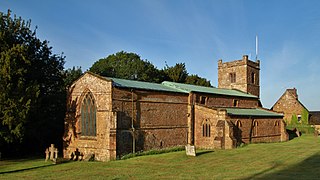
Wardington is a village and civil parish in Oxfordshire, about 4 miles (6.4 km) northeast of Banbury. The village consists of two parts: Wardington and Upper Wardington. The village is on a stream that rises in Upper Wardington and flows north to join the River Cherwell.

<span class="mw-page-title-main">Fulbrook, Oxfordshire</span> Human settlement in England

Fulbrook is a village and civil parish immediately northeast of Burford in West Oxfordshire. The 2011 Census recorded the parish's population as 437.

<span class="mw-page-title-main">Stanton Harcourt</span> Human settlement in England

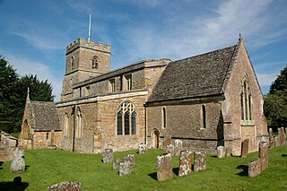
Stanton Harcourt is a village and civil parish in Oxfordshire about 4 miles (6.4 km) southeast of Witney and about 6 miles (10 km) west of Oxford. The parish includes the hamlet of Sutton, 12 mile (800 m) north of the village. The 2011 Census recorded the parish's population as 960.

<span class="mw-page-title-main">Cassington</span> Human settlement in England

Cassington is a village and civil parish in Oxfordshire about 5 miles (8 km) northwest of Oxford. The village lies on gravel strata about 12 mile (800 m) from the confluence of the River Evenlode with the River Thames. The parish includes the hamlet of Worton northeast of the village and the site of the former hamlet of Somerford to the south. Somerford seems to have been abandoned early in the 14th century. Cassington is formed of two parts, "upper" and "lower", each with its own village green. The 2011 Census recorded the parish's population as 750.

<span class="mw-page-title-main">Church Hanborough</span> Human settlement in England

Church Hanborough is a village in Hanborough civil parish about 5 miles (8 km) northeast of Witney in Oxfordshire.

<span class="mw-page-title-main">Great Tew</span> Village in Oxfordshire, England

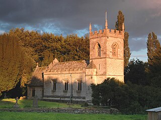
Great Tew is an English village and civil parish in Oxfordshire, about 5 miles (8 km) north-east of Chipping Norton and 8 miles (13 km) south-west of Banbury. The 2011 Census gave a parish population of 156. This qualifies it for an annual parish meeting, not a monthly parish council. The village has largely belonged since the 1980s to the Johnston family, as the Great Tew Estate, with renovations and improvements.

<span class="mw-page-title-main">Hornton</span> Human settlement in England

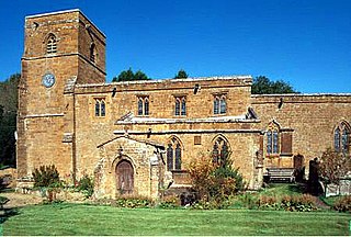
Hornton is a village and civil parish about 3 miles (5 km) northwest of Banbury in Oxfordshire.

<span class="mw-page-title-main">Kiddington</span> Village in Oxfordshire, England

Kiddington is a village in the civil parish of Kiddington with Asterleigh, in the West Oxfordshire district, in the county of Oxfordshire, England. The village is on the River Glyme, just north of the A44 road between Woodstock and Chipping Norton, about 7 miles (11 km) southeast of Chipping Norton. In 1891 the parish had a population of 215. On 1 October 1895 the parish was abolished and nerged with Asterleigh to form "Kiddington with Asterleigh".

<span class="mw-page-title-main">Alkerton, Oxfordshire</span> Human settlement in England

Alkerton is a village and former civil parish, now in the parish of Shenington with Alkerton, in the Cherwell district, in the county of Oxfordshire, England. It is on the county boundary with Warwickshire, about 5 miles (8 km) west of Banbury. In 1961 the parish had a population of 82. On 1 April 1970 the parish was abolished and merged with Shenington to form "Shenington with Alkerton".

<span class="mw-page-title-main">Little Tew</span> Human settlement in England

Little Tew is an English village and civil parish about 4+12 miles (7 km) northeast of Chipping Norton and 8+12 miles (14 km) southwest of Banbury in Oxfordshire. The parish is bounded to the northwest by the River Swere and a road between Little Tew and Hook Norton, to the north by a tributary of the River Cherwell and to the south by an ancient drovers' road called Green Lane. The remaining parts of the parish bounds are field boundaries. The 2011 Census recorded the parish's population as 253.

<span class="mw-page-title-main">Sandford St Martin</span> Human settlement in England

Sandford St Martin is a village and civil parish in West Oxfordshire about 7 miles (11 km) east of Chipping Norton and about 12 miles (19 km) south of Banbury. The 2011 Census recorded the parish's population as 209.

<span class="mw-page-title-main">Steeple Barton</span> Human settlement in England

Steeple Barton is a civil parish and scattered settlement on the River Dorn in West Oxfordshire, about 8+12 miles (13.7 km) east of Chipping Norton, a similar distance west of Bicester and 9 miles (14 km) south of Banbury. Most of the parish's population lives in the village of Middle Barton, about 1 mile (1.6 km) northwest of the settlement of Steeple Barton. The 2011 Census recorded the parish's population as 1,523. Much of the parish's eastern boundary is formed by the former turnpike between Oxford and Banbury, now classified the A4260 road. The minor road between Middle Barton and Kiddington forms part of the western boundary. Field boundaries form most of the rest of the boundaries of the parish.

<span class="mw-page-title-main">Westcott Barton</span> Human settlement in England

Westcott Barton, also spelt Wescot Barton or Wescote Barton, is a village and civil parish on the River Dorn in West Oxfordshire about 7 miles (11 km) east of Chipping Norton and about 9+12 miles (15 km) south of Banbury, in the county of Oxfordshire, England. The parish is bounded to the north by Cockley Brook, a tributary of the River Dorn. A minor road to Kiddington forms part of the eastern boundary, another minor road forms part of the western boundary and the remainder of the parish boundaries are field boundaries. Westcott Barton's main area of housing is on the eastern boundary of the parish and contiguous with the village of Middle Barton in the neighbouring parish of Steeple Barton. The 2011 Census recorded the parish's population as 244.

<span class="mw-page-title-main">Nether Worton</span> Human settlement in England

Nether Worton is a hamlet in the civil parish of Worton, in the West Oxfordshire district, in the county of Oxfordshire, England. It is about 6+12 miles (10.5 km) south of Banbury and 7 miles (11 km) east of Chipping Norton. In 1931 the parish had a population of 42. On 1 April 1932 the parish was abolished and merged with Over Worton to form "Worton".

<span class="mw-page-title-main">Over Worton</span> Human settlement in England

Over Worton is a hamlet in the civil parish of Worton, in the West Oxfordshire district, in the county of Oxfordshire, England, about 7 miles (11 km) south of Banbury and 7+12 miles (12 km) east of Chipping Norton. In 1931 the parish had a population of 72. On 1 April 1932 the parish was abolished and merged with Nether Worton to form "Worton".

References

  1. "Area: Duns Tew (Parish): Key Figures for 2011 Census: Key Statistics". Neighbourhood Statistics . Office for National Statistics . Retrieved 7 November 2015.
  2. Crossley 1983, pp. 75–81.
  3. 1 2 3 4 5 6 7 8 9 10 11 12 13 14 15 16 17 18 19 20 Crossley 1983 , pp. 209–222
  4. 1 2 Sherwood & Pevsner 1974, p. 590.
  5. Sherwood & Pevsner 1974, p. 591.
  6. 1 2 3 4 5 6 Davies, Peter (13 December 2006). "Duns Tew S Mary Magd". Dove's Guide for Church Bell Ringers . Central Council for Church Bell Ringers . Retrieved 4 January 2012.
  7. 1 2 3 Dovemaster (25 June 2010). "Bell Founders". Dove's Guide for Church Bell Ringers . Central Council for Church Bell Ringers. Archived from the original on 4 September 2015. Retrieved 4 January 2012.
  8. Archbishops' Council. "Benefice of Westcote Barton with Steeple Barton, Duns Tew and Sandford Saint Martin and Over with Nether Worton". A Church Near You . Church of England. Archived from the original on 4 March 2016. Retrieved 7 November 2015.
  9. The Barton Benefice ~ Oxfordshire, UK
  10. 1 2 Alsager.
  11. @BBCArchive (23 February 2021). "#OnThisDay 1976: Nationwide visited a..." (Tweet) via Twitter.
  12. "The White Horse". Archived from the original on 22 May 2009. Retrieved 17 March 2009.
  13. Community Action Groups: Oxfordshire: Duns Tew Community Action Group Archived 15 January 2010 at the Wayback Machine

Sources