Juniper Hill

Last updated

Juniper Hill
Oxfordshire UK location map.svg
Red pog.svg
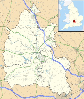
Juniper Hill
Juniper Hill shown within Oxfordshire
OS grid reference SP579324
Civil parish
  • Cottisford
District
Shire county
Region
Country England
Sovereign state United Kingdom
Post town Brackley
Postcode district NN13
Dialling code 01280
Police Thames Valley
Fire Oxfordshire
Ambulance South Central
EU Parliament South East England
UK Parliament
List of places
UK
England
Oxfordshire
51°59′17″N1°09′29″W / 51.988°N 1.158°W / 51.988; -1.158 Coordinates: 51°59′17″N1°09′29″W / 51.988°N 1.158°W / 51.988; -1.158

Juniper Hill is a hamlet in the civil parish of Cottisford in Oxfordshire. Juniper Hill is just over 2 miles (3.2 km) south of Brackley in neighbouring Northamptonshire.

Hamlet (place) small settlement in a rural area

A hamlet is a small human settlement. In different jurisdictions and geographies, hamlets may be the size of a town, village or parish, be considered a smaller settlement or subdivision or satellite entity to a larger settlement. The word and concept of a hamlet have roots in the Anglo-Norman settlement of England, where the old French hamlet came to apply to small human settlements. In British geography, a hamlet is considered smaller than a village and distinctly without a church.

Cottisford village and civil parish in Cherwell district, Oxfordshire, England

Cottisford is a village and civil parish in Oxfordshire, about 3.5 miles (5.6 km) south of Brackley in neighbouring Northamptonshire. The parish's northern and northwestern boundaries form part of the boundary between the two counties. The parish includes the hamlet of Juniper Hill about 1 mile (1.6 km) northwest of Cottisford. The 2011 Census recorded the parish's population as 216.

Oxfordshire County of England

Oxfordshire is a county in South East England. The ceremonial county borders Warwickshire to the north-west, Northamptonshire to the north-east, Buckinghamshire to the east, Berkshire to the south, Wiltshire to the south-west and Gloucestershire to the west.

Juniper Hill was named after the common juniper, Juniperus communis , which originally grew in the area. [1] In 1754 there were only two cottages in the area. [1] However, on the 1841 census there are 16 households in the village, and by 1901 there were 25 households in the village. The local inn, established about 1860, was known as the 'Fox'. [1]

<i>Juniperus communis</i> species of plant

Juniperus communis, the common juniper, is a species of conifer in the genus Juniperus, in the family Cupressaceae. It has the largest geographical range of any woody plant, with a circumpolar distribution throughout the cool temperate Northern Hemisphere from the Arctic south in mountains to around 30°N latitude in North America, Europe and Asia. Relict populations can be found in the Atlas Mountains of Africa.

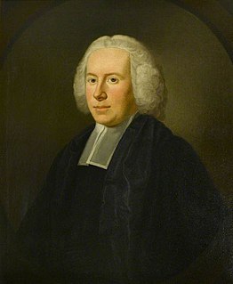
Flora Thompson was born in Juniper Hill in 1876. She fictionalised the hamlet as Lark Rise in her Lark Rise to Candleford trilogy.

Flora Thompson was an English novelist and poet best known for her semi-autobiographical trilogy about the English countryside, Lark Rise to Candleford.

<i>Lark Rise</i> 1939 semi-autobiographical novel by Flora Thompson

Lark Rise is a 1939 semi-autobiographical novel by the English author Flora Thompson. It was illustrated by Lynton Lamb.

<i>Lark Rise to Candleford</i> Trilogy of semi-autobiographical novels by Flora Thompson

Lark Rise to Candleford is a trilogy of semi-autobiographical novels about the countryside of north-east Oxfordshire and Buckinghamshire, England, at the end of the 19th century. They were written by Flora Thompson and first published together in 1945. The stories were previously published separately as Lark Rise in 1939, Over to Candleford in 1941 and Candleford Green in 1943.
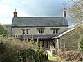
Related Research Articles

Cadmore village in United Kingdom

Cadmore, also known as Cadmore End, is a village in the civil parish of Lane End in the English county of Buckinghamshire.

Trotton with Chithurst civil parish in England

Trotton with Chithurst is a civil parish in the Chichester district of West Sussex, England. Trotton is on the A272 road ten kilometres (7 miles) west of Midhurst. Chithurst is about one mile (2 km) north west of Trotton. The parish also contains the hamlet of Dumpford.

St Clements, Oxford

St Clement's is a district in Oxford, England, on the east bank of the River Cherwell. Its main road, St Clement's Street, links The Plain near Magdalen Bridge with London Place at the foot of Headington Hill at the junction with Marston Road to the north.

Bullingdon is an ancient hundred in the south-east of the county of Oxfordshire.

Fringford village and civil parish in Cherwell district, Oxfordshire, England

Fringford is a village and civil parish in Oxfordshire, about 4 miles (6.4 km) northeast of Bicester. The parish is bounded to the east by the Roman road that linked Alchester Roman Town with Roman Towcester, to the south by a brook that joins the River Bure, to the north mostly by a brook that is a tributary of the River Great Ouse, and to the west by field boundaries. Fringford village is in the north of the parish, surrounded on two sides by a bend in the tributary of the Great Ouse.

River Ray river in Oxfordshire and Buckinghamshire in the United Kingdom

The River Ray is a river in Buckinghamshire and Oxfordshire, England. It rises at Quainton Hill and flows west through a flat countryside for around 25 km or 15 miles. It passes the village of Ambrosden and then flows through Otmoor. It joins the River Cherwell near Islip.

John Russell Greenhill English priest

Rev. John Russell Greenhill was an English cleric, known as the owner of Chequers, Buckinghamshire.

Middle Aston village and civil parish in Cherwell district, Oxfordshire, England

Middle Aston is a hamlet and civil parish in the English county of Oxfordshire, about 7 miles (11 km) northwest of Bicester. It used to have a country house, Middle Aston House, but this was demolished early in the 19th century. The house was replaced in the 1890s by extending the manor farmhouse. The building is now a conference center.

Sibford Ferris village and civil parish in Cherwell district, Oxfordshire, England

Sibford Ferris is a village and civil parish about 6.5 miles (10.5 km) west of Banbury in Oxfordshire. It is on the south side of the Sib valley opposite its larger sister village, Sibford Gower. The 2011 Census recorded the parish's population as 476.

Burdrop village in United Kingdom

Burdrop is a village in Sibford Gower civil parish, about 6.5 miles (10.5 km) west of Banbury in Oxfordshire, England. Burdrop is contiguous with Sibford Gower and sometimes considered part of the village.

Lyneham, Oxfordshire village and civil parish in West Oxfordshire, England

Lyneham is a village and civil parish about 5 miles (8 km) southwest of Chipping Norton, Oxfordshire. It is bounded to the southwest by the River Evenlode, to the southeast by the A361 road linking Chipping Norton and Burford, and on other sides by field boundaries. The 2011 Census recorded the parish's population as 153.

Hardwick with Tusmore is a civil parish in Oxfordshire, England. It was formed in 1932 by merger of the parishes of Hardwick and Tusmore.

Newton Purcell with Shelswell is a civil parish in Oxfordshire, England. It was formed in 1932 by merger of the parishes of Newton Purcell and Shelswell.

Shenington with Alkerton is a civil parish in Oxfordshire, England. It comprises the village of Shenington, which was an exclave of Gloucestershire until the Counties Act 1844 transferred it to Oxfordshire and the village of Alkerton, which was always part of Oxfordshire. It covers 9.60 km² and as at the 2011 census had a population of 425 people.

Mary Doreen Lobel was an historian who edited several volumes of the Victoria County History and a three-volume British Atlas of Historic Towns.

The Swan (Tetsworth inn) historic former Grade II Elizabethan coaching inn in Tetsworth, United Kingdom

The Swan is an historic former Grade II* Elizabethan coaching inn in Tetsworth built about 1600 CE with 17th-century and 18th-century additions.

John de Hotham academic administrator

John de Hotham was an English medieval college head and university chancellor.

The parliamentary visitation of the University of Oxford was a political and religious purge taking place from 1647, for a number of years. Many Masters and Fellows of Colleges lost their positions.

References

  1. 1 2 3 Mary D. Lobel (ed.) (1959). "Parishes: Cottisford". A History of the County of Oxford: Volume 6. Institute of Historical Research. Retrieved 22 November 2013.

Further reading

Victoria County History

The Victoria History of the Counties of England, commonly known as the Victoria County History or the VCH, is an English history project which began in 1899 and was dedicated to Queen Victoria with the aim of creating an encyclopaedic history of each of the historic counties of England. In 2012 the project was rededicated to Queen Elizabeth II in celebration of her Diamond Jubilee year. Since 1933 the project has been coordinated by the Institute of Historical Research in the University of London.