Caversfield

Last updated

Caversfield
Caversfield StLaurence SE.jpg
St Laurence's parish church
Oxfordshire UK location map.svg
Red pog.svg
Caversfield
Location within Oxfordshire
Area4.52 km2 (1.75 sq mi)
Population1,788 (2011 Census)
  Density 396/km2 (1,030/sq mi)
OS grid reference SP5825
Civil parish
  • Caversfield
District
Shire county
Region
Country England
Sovereign state United Kingdom
Post town Bicester
Postcode district OX27
Dialling code 01869
Police Thames Valley
Fire Oxfordshire
Ambulance South Central
UK Parliament
Website Caversfield Parish Council
List of places
UK
England
Oxfordshire
51°55′26″N1°09′32″W / 51.924°N 1.159°W / 51.924; -1.159

Caversfield is a village and civil parish about 1+12 miles (2.4 km) north of the centre of Bicester. In 1844 Caversfield became part of Oxfordshire, but until then it was always an exclave of Buckinghamshire. [1] The 2011 Census recorded the parish's population as 1,788. [2]

Contents

Early history

The ancient Roman road between Alchester and Towcester, now the A4421, forms the eastern boundary of the parish.

Caversfield's toponym has evolved from Cavrefelle in the 11th century through Kaueresfuld, Chauresfeld, Caffresfeld, Caueresfeud and Kaveresfeld (12th–13th centuries), and by the 18th century it was Catesfield. [1]

Before the Norman Conquest of England the manor was held by one Edward, who was a man of Tostig Godwinson, Earl of Northumbria. [1] The Domesday Book records that in 1086 Caversfield was one of the manors owned by William de Warenne, 1st Earl of Surrey. [1] William's descendants retained Caversfield until the beginning of the 14th century. [1]

By 1317 Caversfield was held by Aymer de Valence, 2nd Earl of Pembroke, and when the Earl died in 1324 it passed to his niece Joan. [1] She was the wife of David II Strathbogie, Earl of Atholl, who although Scottish had become a peer of England after King Robert the Bruce deposed and exiled him for rebellion. Caversfield remained with the Earl of Atholl's descendants until 1375, when it passed to the heirs of a different branch of the de Warenne family. [1]

By the 12th century the Gargate family held the feudal tenancy of Caversfield. In 1236 Muriel de Ros and Isabel de Munbury, the daughters of Hugh Gargate, endowed the tenancy of half of the manor to the Augustinian Priory at Bicester. [1] The priory retained this holding until the Dissolution of the Monasteries after 1536. [1]

In the 13th century the Gargate family owned a watermill, a windmill and a house where the manorial court was held. [1] The watermill was presumably on the small River Bure which rises at Bainton, flows south through Caversfield and Bicester and around Graven Hill, and joins the River Ray at Merton. No trace of either mill is known to survive, and the original manor house has gone.

Parish church

Saxon window in the south side of St Laurence's church tower Caversfield StLaurence Tower SouthWindow2.jpg
Saxon window in the south side of St Laurence's church tower

The oldest part of the small Church of England parish church of Saint Laurence is the Saxon ground stage of the bell tower, [1] probably from the 10th century. [3] The nave and chancel were rebuilt late in the 12th century. [3] Early in the 13th century the chancel was remodelled again [3] in the Early English Gothic style with two lancet windows at its east end, and the bell-stage of the tower was either added or rebuilt. [1] The small north and south aisles were added around the same time. Each aisle is linked to the nave by an arcade of two bays, in which the style of the piers is of about AD 1180 but the Early English Gothic style of the arches is of about 1230. [3] The south walls of the church include a lancet window, a Decorated Gothic window from early in the 14th century and a Perpendicular Gothic window from late in the 15th century. [1] [3]

In the 18th century the north and south aisles of St Laurence church were demolished and the two arcades blocked up. [3] In 1874 the Gothic Revival architect Henry Woodyer restored the chancel, rebuilt the aisles and added a vestry to the east of the north aisle. [3]

St Laurence's parish is now part of the benefice of Bicester with Caversfield. [4]

Church bells

Until the 20th century the tower had three bells, [1] including a treble bell that was cast in about 1218 [5] for Hugh and Sibilla Gargate and is believed to be the oldest inscribed bell in England. [6] In the 20th century this bell was removed from the tower and mounted as an historic exhibit inside the church.

The tower now has a ring of five bells. John Taylor & Co of Loughborough cast the tenor bell in 1874 and the fourth bell in 1876. Mears & Stainbank of the Whitechapel Bell Foundry cast the third bell in 1928 and added new treble and second bells in 1949. [5]

CWGC graves in St Laurence's parish churchyard Caversfield StLaurence CWGC.jpg
CWGC graves in St Laurence's parish churchyard

Commonwealth War Graves

St Lawrence's parish churchyard includes 25 Commonwealth War Graves [7] connected with RAF Bicester, dating from before and during the Second World War. This was a training station for Bomber Command and a number of the burials are of airmen killed in training accidents. 19 are RAF airmen, including one Australian and one Canadian serving in the RAF. Four are RCAF airmen, one is from the RNZAF and one is a soldier from the Royal Artillery.

Economic and social history

An open field system of farming prevailed in the parish until 1780, when an inclosure act enabled the enclosure of the common land of the parish. [1]

Caversfield is on the old main road between Bicester and Banbury via Aynho. In 1791 an Act of Parliament made both the Bicester–Aynho road and the Bicester–Finmere stretch of the old Roman road into turnpikes. [8] The two roads ceased to be turnpikes in 1877. [8] In the 1920s the Bicester–Banbury road was classified as part of the A41 and the Bicester–Finmere road was part of the A421. After the M40 motorway was completed in 1990, the Bicester–Banbury road was downgraded to B4100 and the Bicester–Finmere road was reclassified A4421.

In the 19th century Caversfield's status as an exclave of Buckinghamshire was brought to an end. The Reform Act 1832 removed the parish from the Buckingham parliamentary constituency, and in 1839 two further Acts placed exclaves such as Caversfield under their surrounding counties' magistrates and county constabularies. Finally the Counties (Detached Parts) Act 1844 transferred Caversfield to Oxfordshire for all remaining purposes.

The architect C.R. Cockerell designed Caversfield House, which was built in 1842–45 on the site of the former manor house. [9] The architect William Wilkinson designed the neo-Tudor style Brashfield House, which was built in 1872–75 in the east of the parish by the Roman Road. [9]

Until the 20th century Caversfield was a manor and parish with no village and a very small population. [1] However, in 1911 Bicester Airfield was created just east of the Roman road in Launton parish. At the end of the First World War the airfield became RAF Bicester and subsequently housing for RAF personnel was built in Skimmingdish Lane in the eastern part of Caversfield parish. RAF operations ceased in 2004, and the Skimmingdish Lane accommodation is now used by the Defence Logistics Organisation. The parish also now includes accommodation for USAFE personnel serving at the RAF Croughton communications base in Northamptonshire about 5 miles (8 km) north of Caversfield.

Late in the 20th century Bicester has been greatly expanded with new housing. Parts of the Bure Park housing estate, although in Bicester, are in Caversfield civil parish.

Related Research Articles

<span class="mw-page-title-main">Upper Heyford, Oxfordshire</span> Human settlement in England

Upper Heyford is a village and civil parish about 6 miles (10 km) northwest of Bicester in Oxfordshire, England. The 2011 Census recorded the parish's population as 1,295.

<span class="mw-page-title-main">Aynho</span> Human settlement in England

Aynho is a village and civil parish in West Northamptonshire, England, on the edge of the Cherwell valley 6 miles (9.7 km) south-east of the north Oxfordshire town of Banbury and 7 miles (11 km) southwest of Brackley.

<span class="mw-page-title-main">Ambrosden</span> Human settlement in England

Ambrosden is a village and civil parish in Cherwell, Oxfordshire, England, 3 miles (5 km) southwest of Bicester to which it is linked by the A41 road, and 13 miles (21 km) from Oxford. The 2011 Census recorded the parish's population as 2,248. The parish is bounded by the River Ray to the south, its tributary the River Bure to the west, the outskirts of Bicester to the north and field boundaries to the east.

<span class="mw-page-title-main">Bucknell, Oxfordshire</span> Village in Oxfordshire, England

Bucknell is a village and civil parish 2+12 miles (4 km) northwest of Bicester in Oxfordshire, England. The 2011 Census recorded the parish's population as 260.

<span class="mw-page-title-main">Finmere</span> Human settlement in England

Finmere is a village and civil parish in Oxfordshire, south of the River Great Ouse. It is on the county boundary with Buckinghamshire, almost 4 miles (6 km) west of Buckingham and just over 4 miles (6 km) east of Brackley in Northamptonshire. The 2011 Census recorded the parish's population as 466.

<span class="mw-page-title-main">Launton</span> Human settlement in England

Launton is a village and civil parish on the eastern outskirts of Bicester, Oxfordshire, England. The 2011 Census recorded the parish's population as 1,204.

<span class="mw-page-title-main">Middleton Stoney</span> Human settlement in England

Middleton Stoney is a village and civil parish about 2+12 miles (4 km) west of Bicester, Oxfordshire. The 2011 Census recorded the parish's population as 331.

<span class="mw-page-title-main">Shenington</span> Human settlement in England

Shenington is a village and former civil parish, now in the parish of Shenington with Alkerton, in the Cherwell district, in the county of Oxfordshire, England. It is about 5 miles (8 km) west of Banbury, it was an exclave of Gloucestershire until the Counties Act 1844 transferred it to Oxfordshire. Shenington is on Oxfordshire's boundary with Warwickshire. Shenington was an ancient parish of 1,628 acres (659 ha). In 1961 the parish had a population of 232. On 1 April 1970 the parish was abolished and merged with Alkerton to form "Shenington with Alkerton".

<span class="mw-page-title-main">Rousham</span> Human settlement in England

Rousham is a village and civil parish beside the River Cherwell in Oxfordshire. The village is about 6+12 miles (10.5 km) west of Bicester and about 6 miles (10 km) north of Kidlington. The parish is bounded by the River Cherwell in the east, the A4260 main road between Oxford and Banbury in the west, partly by the B4030 in the north, and by field boundaries with Tackley parish in the south. The 2001 Census recorded the parish's population as 80. Rousham was founded early in the Anglo-Saxon era. Its toponym is derived from Old English meaning Hrothwulf's ham or farm.

<span class="mw-page-title-main">Mixbury</span> Human settlement in England

Mixbury is a village and civil parish in Oxfordshire, about 2.5 miles (4 km) southeast of Brackley in Northamptonshire.

<span class="mw-page-title-main">Chesterton, Oxfordshire</span> Human settlement in England

Chesterton is a village and civil parish on Gagle Brook, a tributary of the Langford Brook in north Oxfordshire. The village is about 1+12 miles (2.4 km) southwest of the market town of Bicester. The village has sometimes been called Great Chesterton to distinguish it from the hamlet of Little Chesterton, about 34 mile (1.2 km) to the south in the same parish. The 2011 Census recorded the parish population as 850.

<span class="mw-page-title-main">Alkerton, Oxfordshire</span> Human settlement in England

Alkerton is a village and former civil parish, now in the parish of Shenington with Alkerton, in the Cherwell district, in the county of Oxfordshire, England. It is on the county boundary with Warwickshire, about 5 miles (8 km) west of Banbury. In 1961 the parish had a population of 82. On 1 April 1970 the parish was abolished and merged with Shenington to form "Shenington with Alkerton".

<span class="mw-page-title-main">Hanwell, Oxfordshire</span> Human settlement in England

Hanwell is a village and civil parish in Oxfordshire, about 2 miles (3 km) northwest of Banbury. Its area is 1,240 acres (500 ha) and its highest point is about 500 feet (150 m) above sea level. The 2011 Census recorded the parish's population as 263.

<span class="mw-page-title-main">Clanfield, Oxfordshire</span> Human settlement in England

Clanfield is a village and civil parish about three miles (5 km) south of Carterton, Oxfordshire. The parish includes the hamlet of Little Clanfield one mile (1.6 km) west of the village, on Little Clanfield Brook which forms the parish's western boundary. The parish's eastern boundary is Black Bourton Brook and its southern boundary is Radcot Cut, an artificial watercourse on the River Thames floodplain. The 2011 Census recorded the parish's population as 879.

<span class="mw-page-title-main">St Mary's Church, North Leigh</span> Church in Oxfordshire , United Kingdom

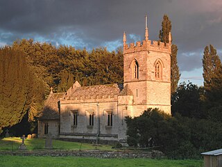
The Parish Church of Saint Mary, North Leigh is the Church of England parish church of North Leigh, a village about 3 miles (5 km) northeast of Witney in Oxfordshire.

<span class="mw-page-title-main">Fritwell</span> Human settlement in England

Fritwell is a village and civil parish about 5+12 miles (9 km) northwest of Bicester in Oxfordshire. The 2011 Census recorded the parish's population as 736.

<span class="mw-page-title-main">Souldern</span> Human settlement in England

Souldern is a village and civil parish in Oxfordshire about 7 miles (11 km) northwest of Bicester and a similar distance southeast of Banbury. The parish is bounded to the west by the River Cherwell and to the east by field boundaries. Its northern boundary is Ockley Brook, a tributary of the Cherwell that forms the county boundary with Northamptonshire. The parish's southern boundaries are the main road between Bicester and Adderbury and the minor road between Souldern and Somerton. The 2011 Census recorded the parish's population as 370.

<span class="mw-page-title-main">Church of the Annunciation to the Blessed Virgin Mary, Souldern</span> Church in Oxfordshire , United Kingdom

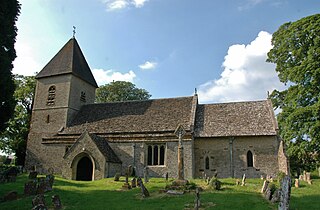
The Parish Church of the Annunciation to the Blessed Virgin Mary is the Church of England parish church of Souldern, a village in Oxfordshire about 7 miles (11 km) northwest of Bicester and a similar distance southeast of Banbury.

<span class="mw-page-title-main">Steeple Barton</span> Human settlement in England

Steeple Barton is a civil parish and scattered settlement on the River Dorn in West Oxfordshire, about 8+12 miles (13.7 km) east of Chipping Norton, a similar distance west of Bicester and 9 miles (14 km) south of Banbury. Most of the parish's population lives in the village of Middle Barton, about 1 mile (1.6 km) northwest of the settlement of Steeple Barton. The 2011 Census recorded the parish's population as 1,523. Much of the parish's eastern boundary is formed by the former turnpike between Oxford and Banbury, now classified the A4260 road. The minor road between Middle Barton and Kiddington forms part of the western boundary. Field boundaries form most of the rest of the boundaries of the parish.

<span class="mw-page-title-main">Westcott Barton</span> Human settlement in England

Westcott Barton, also spelt Wescot Barton or Wescote Barton, is a village and civil parish on the River Dorn in West Oxfordshire about 7 miles (11 km) east of Chipping Norton and about 9+12 miles (15 km) south of Banbury, in the county of Oxfordshire, England. The parish is bounded to the north by Cockley Brook, a tributary of the River Dorn. A minor road to Kiddington forms part of the eastern boundary, another minor road forms part of the western boundary and the remainder of the parish boundaries are field boundaries. Westcott Barton's main area of housing is on the eastern boundary of the parish and contiguous with the village of Middle Barton in the neighbouring parish of Steeple Barton. The 2011 Census recorded the parish's population as 244.

References

St Laurence's parish church and churchyard from the southwest, with the Commonwealth war graves visible beyond the tree centre left Caversfield StLaurence SW.jpg
St Laurence's parish church and churchyard from the southwest, with the Commonwealth war graves visible beyond the tree centre left
  1. 1 2 3 4 5 6 7 8 9 10 11 12 13 14 15 16 Page 1927 , pp. 157–163
  2. "Area: Caversfield (Parish): Key Figures for 2011 Census: Key Statistics". Neighbourhood Statistics . Office for National Statistics . Retrieved 6 April 2013.
  3. 1 2 3 4 5 6 7 Sherwood & Pevsner 1974 , p. 523
  4. Archbishops' Council. "St Laurence, Caversfield". A Church Near You . Church of England . Retrieved 25 March 2011.
  5. 1 2 "Caversfield S Lawrence". Dove's Guide for Church Bell Ringers . Retrieved 25 March 2011.
  6. "St Laurence, Caversfield". Oxford Diocesan Guild of Church Bell Ringers, Bicester Branch.
  7. CWGC. "Caversfield (St Laurence) Churchyard". Commonwealth War Graves Commission . Retrieved 25 March 2011.
  8. 1 2 Rosevear, Alan (2 June 2010). "List of Turnpike Trusts". Turnpike Roads in England. Alan Rosevear. Retrieved 25 March 2011.
  9. 1 2 Sherwood & Pevsner 1974, p. 524.

Sources