Horton-cum-Studley is a village and civil parish in the Cherwell district, in Oxfordshire, England, about 6+1⁄2 miles (10.5km) northeast of the centre of Oxford and bordering Otmoor, and is one of the "Seven Towns" of Otmoor. The 2011 Census recorded the parish's population as 455.[1] A majority of residents in the village work in the Healthcare and Educational Sectors.[2]
The hamlet of Studley was originally in two parts: one in Oxfordshire and the other in the Hundred of Ashendon in Buckinghamshire. Horton was always part of Oxfordshire. Horton and all of Studley, including the Buckinghamshire part, were originally part of the ancient parish of Beckley. The Buckinghamshire part of Studley became a separate civil parish, but was then transferred to Oxfordshire under the Reform Act 1832 and the Counties (Detached Parts) Act 1844. Meanwhile Horton and the Oxfordshire part of Studley had been separated from Beckley to form the civil parish of Horton-cum-Studley. The two parts of Studley were reunited in 1932, when the Studley and Horton-cum-Studley civil parishes were finally merged.[3]
Horton's toponym is derived from Old Englishhoru 'dirt' and tūn 'settlement, farm, estate', presumably meaning 'farm on muddy soil'.[4] The oldest known record of Horton is from the reign of Æthelred the Unready: a charter of 1005-11 that records its agricultural land as five hides. However, the Domesday Book of 1086 has no separate entry for Horton[3] as it had been part of the manor of Beckley since before the Norman Conquest of England. Until the Norman conquest of England the manor of Beckley was one of many that belonged to Saxon Wigod, thegn of Wallingford. Thereafter ownership of Horton followed the same descent as that of Beckley.
Before the Norman Conquest a man called Azor son of Toti, who held allegiance to Edith of Wessex, consort of Edward the Confessor, held the manor of Lesa or Ash. Azor also had the manors of Iffley in Oxfordshire and Lillingstone Lovell in Buckinghamshire, and other Oxfordshire landholdings at Chastleton and Marsh Baldon. The Domesday Book in 1086 recorded that Roger d'Ivry held the manor, which was assessed at two hides. Ash followed the same descent as Beckley and Horton until 1300, when they were estates of the Honour of St Valery.[3] By 1190 the tenants of the Honour of St Valery at Ash were the Ash and De Bosco families.
Between 1190 and 1213 the two families granted land at either Ash or Marlake (see below) to the Knights Templar. The Order may have disposed of the land before its dissolution in the 14th century, as the Hundred Rolls for the Hundred of Bullingdon for 1279 do not record any Templar landholding in Beckley parish.[3] In 1361 John of Ash enfeoffed John and Margaret Appleby, the lord and lady of Boarstall. In 1365 the Applebys granted Ash to trustees, who in turn enfeoffed the manor to a second set of trustees. In 1389 the latter trustees were licensed to alienate Ash to the Prioress of Studley. John Appleby died in 1371 and Margaret quitclaimed her rights in 1391.[3]
Studley
Studley Priory
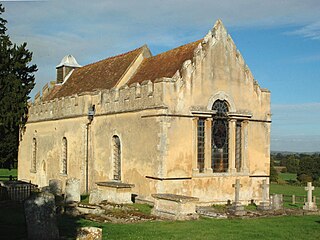
The founding date of the BenedictineStudley Priory is not known, but earliest known record of its existence is from 1176, when Bernard de St Valery granted half a hide of land at Horton to the priory. Studley's toponym is derived from Old English meaning "pasture for horses". The priory's foundation led to the abandonment of Ash in favour of a new hamlet of Studley that grew up next to the priory. At one time the priory had 50 nuns but by 1445 their number had fallen to nine. In 1520 there were still only 10 nuns and the priory to be significantly in debt. In 1530 the debt was £60 and the buildings were in disrepair.[5] Under the Dissolution of the Monasteries Studley Priory surrendered its lands to the Crown in November 1539, which sold them off in February 1540. John Croke bought the priory's lands at Studley and Horton.[5]
In 1621 another Sir John Croke sold Studley to George Croke, who was a lawyer and in the 1630s defended John Hampden in the ship money case. Sir George died in 1642, leaving his estates to his wife for the remainder of her life, with reversion to their son Thomas and thence to other members of their immediate family. Thomas Croke was a Royalist in the English Civil War so Parliament sequestered his estates in 1644, but they were discharged in 1646.[3] Sir Alexander Croke (1758–1842) succeeded to the estate in 1777. Alexander became a maritime lawyer and was the senior justice of the vice admiralty courts of Nova Scotia from 1801: a term of office that included the War of 1812 against the USA. Sir Alexander also wrote satirical verse, many letters and a genealogy of his family. In 1877 Sir Alexander's younger son John Croke sold Studley to John Henderson. In 1953 Studley was still in his family, with his grandson Captain John Henderson being lord of the manor.[3]
Marlake
Before the English Reformation the Preceptory of the Knights Hospitaller at Sandford-on-Thames held land at Marlake. The Order was suppressed in England under Henry VIII and the Crown seized all its property. John Croke, who had bought Studley Priory's lands in 1542, bought the former Hospitaller estate at Marlake in 1542. In 1877 the Crokes sold Marlake and Studley to John Henderson.[3] Building of the country house called Studley Priory began in the 16th century. The house's plan is irregular, which suggests that parts of the Benedictine priory buildings were absorbed into it. The house had been converted into a hotel by 1953[3] but ceased to be so in 2004.
Chapels and church
St Barnabas' parish church
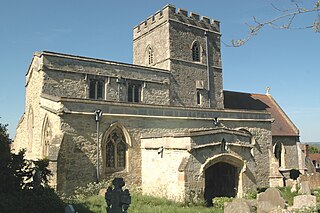
Horton and Studley are more than 2+1⁄2 miles (4km) from the church of their ancient parish of Beckley. There is an isolated record of a chaplain serving Horton in the 13th century, but no subsequent records for about the next 300 years. However, there is a record from 1553 of a chapel at Horton that had clearly been there for some time.[3] About 1639 Sir George Croke had the north wing of Studley Priory converted into a chapel. The old village chapel was allowed to fall into disrepair and by 1685 it had fallen down. Villagers worshipped at the new Priory chapel, and the residents of the almshouses (see below) were duty bound to do so or else half of their weekly allowance would be stopped.[3]
The Church of England parish church of Saint Barnabas was built in 1867, apparently on or close to the site of the former village chapel. This made the Priory chapel unnecessary, so when the Croke family sold Studley to John Henderson in 1877 the chapel was converted into a kitchen and offices.[3] The present St Barnabas' parish church was designed by the Gothic Revival architectWilliam Butterfield and built in 1867. It is built of yellow brick relieved by red and blue brick detailing. It has a nave, chancel and north aisle. St Barnabas' has no tower but there is a west bell-turret with two bells. The stained glass windows are by Alexander Gibbs.[6] Early in the 19th century there were a number of Protestant Nonconformists in Horton and Studley, and some of their homes were licensed for them to worship in. The Methodist chapel was built in 1878.[3]
Economic and social history
Studley had a windmill by 1539, when it was listed among the estates of the priory that had just been dissolved and sold to John Croke. It was recorded on maps in the 17th and 18th centuries and finally on the parish of Beckley's inclosure maps of 1827–31. Its site is recorded by the name Mill Field, at the end of Mill Lane.[3] Sir George Croke established the Studley Almshouse Charity in 1631 by an indenture that gave it an income from land at Easington, Buckinghamshire. The houses were built in 1639 for four local men over 60 years of age and four local women over 50 "well reputed for religion, and of good character and conversation". A further endowment to the charity was added by Sir Richard Ingoldsby, Lady Elizabeth Ingoldsby and Alexander Croke in 1668. The Otmoor Inclosure Award of 1825 added two acres and eight perches to the charity's endowment. The number of beneficiaries was reduced to two men and two women in 1880.[3]
In June 1643 during the English Civil War a force of 500 of Prince Rupert's cavalry reconnoitred Horton, unsuccessfully searching for an advancing force under the Earl of Essex. A few days later Essex advanced and unsuccessfully attacked Islip. After Essex withdrew, a Royalist force from Woodperry returned and drove the sheep off Horton Common.[3] By 1819 Horton had a schoolmaster and by 1833 it had two small schools. In 1871 there were still two schools, but one had a charitable endowment and had 47 pupils. In 1891 the larger school came under the Church of England parish and had 59 pupils. It was still open in 1952 but by then had only 20 pupils.[3] It has since closed. Horton had a post office in 1954[3] but it closed in October 2004.[7]
Inclosures
A map of 1641 shows that by then inclosure had embraced at least two thirds of the Manor of Studley: 670 acres (270ha). This included only a small proportion of the land around the manor house but a much larger proportion of the land of the former hamlets of Ash and Marlake.[3] Studley Mill Field continued to be cultivated under an open field system. By 1786 Horton had no large inclosures but about 150 small ones covering a total of 90 acres (36ha). A further 460 acres (190ha) continued to be worked as common fields. West Farm at Horton was built in the 17th century.[3] In 1829 Otmoor was inclosed and some of its land was added to the parish of Beckley, including 262 acres (106ha) for Horton and 200 acres (81ha) for Studley. In 1831 the parish of Beckley itself was inclosed.[3]
Amenities
Horton-cum-Studley has a public house, formerly known as the Kings Arms, now trading as The Otmoor Lodge Hotel Bar Restaurant. It also has a village hall, the Millennium Hall.[7] There is a Studley Women's Institute[8] and a Horton-cum-Studley Tennis Club.[9] There are regular village events held in the Millennium Hall.[10]
Watts, Victor, ed. (2004). "Horton". The Cambridge Dictionary of English Place-Names: Based on the Collections of the English Place-Name Society. Cambridge: Cambridge University Press. ISBN0521168554.
Monks Risborough is a village and ecclesiastical parish in the civil parish of Princes Risborough, Buckinghamshire, England, lying between Princes Risborough and Great Kimble. The village lies at the foot of the northern scarp of the Chiltern Hills. It is 8 miles (13 km) south of the county town of Aylesbury and 9.5 miles (15.3 km) north of High Wycombe, on the A4010 road.
Brill is a village and civil parish in west Buckinghamshire, England, close to the border with Oxfordshire. It is about 4 miles (6 km) north-west of Long Crendon and 7 miles (11 km) south-east of Bicester. At the 2011 Census, the population of the civil parish was 1,141. Brill has a royal charter to hold a weekly market, but has not done so for many years.
Oakley is a village and civil parish in Buckinghamshire, England. It has an area of 2,206 acres (893 ha) and includes about 400 households. The 2021 Census recorded the population as 1,128.
Ickleton is a village and civil parish about 9 miles (14 km) south of Cambridge in Cambridgeshire, England. The village is beside the River Cam, close to where a southern branch of the Icknield Way crossed the river. The eastern and southern boundaries of the parish form part of the county boundary with Essex, and the Essex town of Saffron Walden is only about 4.5 miles (7 km) southeast of the village.
Merton is a village and civil parish near the River Ray, about 4 miles (6.4 km) south of Bicester in Oxfordshire, England. The 2011 Census recorded the parish's population as 424.
Ambrosden is a village and civil parish in Cherwell, Oxfordshire, England, 3 miles (5 km) southwest of Bicester to which it is linked by the A41 road, and 13 miles (21 km) from Oxford. The 2011 Census recorded the parish's population as 2,248. The parish is bounded by the River Ray to the south, its tributary the River Bure to the west, the outskirts of Bicester to the north and field boundaries to the east.
Blackthorn is a village and civil parish in the Cherwell District of Oxfordshire about 3 miles (5 km) southeast of Bicester. The parish is bounded by the River Ray to the south, tributaries of the Ray to the east and north and field boundaries to the west. The parish's eastern boundary forms part of the county's with Buckinghamshire.
The Counties Act 1844, which came into effect on 20 October 1844, was an Act of Parliament of the United Kingdom which eliminated many outliers or exclaves of counties in England and Wales for civil purposes. The changes were based on recommendations by a boundary commission, headed by the surveyor Thomas Drummond and summarized in a schedule attached to the Parliamentary Boundaries Act 1832. This also listed a few examples of civil parishes divided by county boundaries, most of which were dealt with by later legislation. This Act was repealed in its entirety by the Local Government Act 1972.
Otmoor or Ot Moor is an area of wetland and wet grassland in Oxfordshire, England, located halfway between Oxford and Bicester. It is about 60 metres (200 ft) above sea level, and has an area of nearly 400 hectares.
Addingrove is a former hamlet in Buckinghamshire, about 4 miles (6.4 km) northwest of the market town of Thame in neighbouring Oxfordshire. The settlement is on the B4011 road between Oakley and Long Crendon.
Cogges is an area beside the River Windrush in Witney, in the West Oxfordshire district, in Oxfordshire, England, 0.5 miles (800 m) east of the town centre. It had been a separate village and until 1932 it was a separate civil parish.
Hampton Poyle is a village in the civil parish of Hampton Gay and Poyle, in the Cherwell district, in the county of Oxfordshire, England. It is the Cherwell in valley, about 1 mile (1.6 km) northeast of Kidlington and about 5 miles (8 km) north of the centre of Oxford.
Wheatfield is a civil parish and deserted medieval village about 4 miles (6.4 km) south of Thame in Oxfordshire. Wheatfield's toponym is derived from the Old English for "white field", referring to the ripe crops that the Anglo-Saxons grew on its fertile land. Few of Wheatfield's buildings remain today except the Church of England parish church of Saint Andrew, the former rectory and the former outbuildings of the no-longer-standing manor house.
Beckley is a village in the civil parish of Beckley and Stowood, in the South Oxfordshire district, in the county of Oxfordshire, England. It is about 4.5 miles (7 km) northeast of the centre of Oxford. The 2011 Census recorded the parish of Beckley and Stowood's population as 608. The village is 400 feet (120 m) above sea level on the northern brow of a hill overlooking Otmoor. The hill is the highest part of the parish, rising to 463 feet (141 m) south of the village near Stow Wood. On the eastern brow of the hill is Oxford transmitting station, a television relay mast that is a local landmark. In 1931 the parish of Beckley had a population of 288. On 1 April 1932 the parish was abolished to form "Beckley and Stowood", part also went to "Fencott and Murcott".
Seacourt is a deserted medieval village (DMV) in the civil parish of Wytham, in the Vale of White Horse district, in Oxfordshire, England, near the city of Oxford. The site is now mostly beneath the Oxford Western By-pass (A34), about 0.3 miles (0.48 km) south of the Seacourt/Hinksey Stream crossing.
Mixbury is a village and civil parish in Oxfordshire, about 2.5 miles (4 km) southeast of Brackley in Northamptonshire.
Piddington is a village and civil parish about 4.5 miles (7 km) southeast of Bicester in Oxfordshire, England. It lies close to the border with Buckinghamshire. Its toponym has been attributed to the Old English Pyda's tun. The 2011 Census recorded the parish's population as 370.
Forest Hill is a village in the civil parish of Forest Hill with Shotover, in the South Oxfordshire district, in Oxfordshire, England, about 4.5 miles (7 km) east of Oxford. The village which is about 330 feet (100 m) above sea level is on the northeastern brow of a ridge of hills. The highest point of the ridge is Red Hill, which rises to 440 feet (130 m) just south of the village. The 2011 Census recorded Forest Hill with Shotover's population as 856.
Cottisford is a village and civil parish in Oxfordshire, about 3.5 miles (5.6 km) south of Brackley in neighbouring Northamptonshire. The parish's northern and northwestern boundaries form part of the boundary between the two counties. The parish includes the hamlet of Juniper Hill about 1 mile (1.6 km) northwest of Cottisford. The 2011 Census recorded the parish's population as 216.
Studley Priory was a small house of Benedictine nuns, ruled by a prioress. It was founded some time before 1176 in the hamlet of Studley in what is now the village of Horton-cum-Studley, 7 miles (11 km) northeast of Oxford in Oxfordshire, England, at 1 Horton Hill Road. In 1176, the priory received a grant from Bernard of St. Walery. The nuns were unhappy to be served poor beef and new beer on Thursday and Sunday nights, and no mutton. The priory was declared closed by 1536, but appears to have experienced a brief revival before its suppression in 1539. The priory lands were sold to the Croke family. The family built the house now known as Studley Priory, which still stands in its 10 acres (4.0 ha) of grounds, in 1587; a member of the Croke family was a judge in the 1649 trial of Charles I. The house and its estate was owned by the Croke family until around 1870 when it was sold to the Henderson family, who occupied it until World War II. During the war, it was a sanatorium for Royal Air Force officers.
This page is based on this Wikipedia article Text is available under the CC BY-SA 4.0 license; additional terms may apply. Images, videos and audio are available under their respective licenses.