
Thomas Tesdale (1547–1610) was an English maltster, benefactor of the town of Abingdon in the English county of Berkshire and the primary founding benefactor of Pembroke College, Oxford.
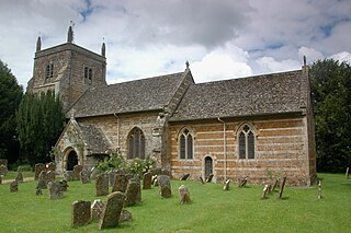
Duns Tew is an English village and civil parish about 7+1⁄2 miles (12 km) south of Banbury in Oxfordshire. The 2011 Census recorded the parish's population as 478. With nearby Great Tew and Little Tew, Duns Tew is one of the three villages known collectively as "The Tews". A 'tew' is believed to be an ancient term for a ridge of land.
Glympton Park is a former deer park at Glympton, 3.5 miles (5.6 km) north of Woodstock, Oxfordshire, England. It includes Glympton House and has a 2,000 acres (810 ha) estate including the village of Glympton, its Norman parish church of St. Mary, 32 stone cottages and 167 acres (68 ha) of parkland.

Barford St Michael is a village and former civil parish, now in the parish of Barford St. John and St. Michael, in the Cherwell district, in the county of Oxfordshire, England. It is on the south bank of the River Swere, about 5 miles (8 km) south of Banbury.

Hempton is a village in Deddington civil parish about 5 miles (8 km) south of Banbury in Oxfordshire. Hempton is on the B4031 road between Deddington and Chipping Norton, which was a turnpike from 1770 until 1871.
Clifton is a hamlet by the River Cherwell in Deddington civil parish about 6 miles (10 km) south of Banbury, Oxfordshire, England. Clifton is on the B4031 road between Deddington and Croughton, Northamptonshire.

Milcombe is a village and civil parish about 5 miles (8 km) southwest of Banbury, Oxfordshire.
Worton is a hamlet in Cassington civil parish, 4.5 miles (7.2 km) northwest of Oxford.
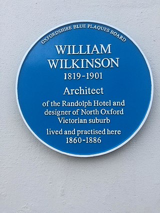
William Wilkinson (1819–1901) was a British Gothic Revival architect who practised in Oxford, England.

Shipton-on-Cherwell and Thrupp is a civil parish in the Cherwell district, in the county of Oxfordshire, England. It was formed in 1955 by removing the hamlet of Thrupp from the parish of Kidlington and merging it with the parish of Shipton-on-Cherwell. It covers 6.04 km² and as at the 2011 census had 493 residents.

Little Tew is an English village and civil parish about 4+1⁄2 miles (7 km) northeast of Chipping Norton and 8+1⁄2 miles (14 km) southwest of Banbury in Oxfordshire. The parish is bounded to the northwest by the River Swere and a road between Little Tew and Hook Norton, to the north by a tributary of the River Cherwell and to the south by an ancient drovers' road called Green Lane. The remaining parts of the parish bounds are field boundaries. The 2011 Census recorded the parish's population as 253.

The Holt Hotel is an historic hotel near Steeple Aston, Oxfordshire, England. It is on the corner of the crossroads between the A4260 Oxford Road and the B4030, about 1 mile (1.6 km) southwest of Steeple Aston opposite a fuel station. It was founded in 1475 as a coaching inn with six rooms and now has 86 rooms. Its restaurant has been awarded a AA Rosette for quality cuisine.
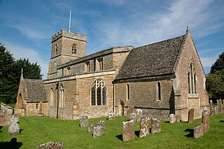
Sandford St Martin is a village and civil parish in West Oxfordshire about 7 miles (11 km) east of Chipping Norton and about 12 miles (19 km) south of Banbury. The 2011 Census recorded the parish's population as 209.

Steeple Barton is a civil parish and scattered settlement on the River Dorn in West Oxfordshire, about 8+1⁄2 miles (13.7 km) east of Chipping Norton, a similar distance west of Bicester and 9 miles (14 km) south of Banbury. Most of the parish's population lives in the village of Middle Barton, about 1 mile (1.6 km) northwest of the settlement of Steeple Barton. The 2011 Census recorded the parish's population as 1,523. Much of the parish's eastern boundary is formed by the former turnpike between Oxford and Banbury, now classified the A4260 road. The minor road between Middle Barton and Kiddington forms part of the western boundary. Field boundaries form most of the rest of the boundaries of the parish.
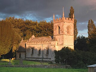
Westcott Barton, also spelt Wescot Barton or Wescote Barton, is a village and civil parish on the River Dorn in West Oxfordshire about 7 miles (11 km) east of Chipping Norton and about 9+1⁄2 miles (15 km) south of Banbury, in the county of Oxfordshire, England. The parish is bounded to the north by Cockley Brook, a tributary of the River Dorn. A minor road to Kiddington forms part of the eastern boundary, another minor road forms part of the western boundary and the remainder of the parish boundaries are field boundaries. Westcott Barton's main area of housing is on the eastern boundary of the parish and contiguous with the village of Middle Barton in the neighbouring parish of Steeple Barton. The 2011 Census recorded the parish's population as 244.

Gagingwell is a hamlet in West Oxfordshire, about 6 miles (10 km) east of Chipping Norton and about 1.8 miles (3 km) east of Enstone. The hamlet surrounds a group of springs that give rise to a brook, which flows southwards almost 1 mile (1.6 km) to join the River Glyme just downstream of the hamlet of Radford.
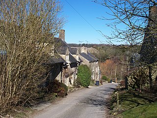
Lidstone is a hamlet on the River Glyme in Oxfordshire, about 3 miles (5 km) east of Chipping Norton. The hamlet is in Enstone civil parish, about 1+1⁄4 miles (2 km) west of Neat Enstone.

Nether Worton is a hamlet in the civil parish of Worton, in the West Oxfordshire district, in the county of Oxfordshire, England. It is about 6+1⁄2 miles (10.5 km) south of Banbury and 7 miles (11 km) east of Chipping Norton. In 1931 the parish had a population of 42. On 1 April 1932 the parish was abolished and merged with Over Worton to form "Worton".

Over Worton is a hamlet in the civil parish of Worton, in the West Oxfordshire district, in the county of Oxfordshire, England, about 7 miles (11 km) south of Banbury and 7+1⁄2 miles (12 km) east of Chipping Norton. In 1931 the parish had a population of 72. On 1 April 1932 the parish was abolished and merged with Nether Worton to form "Worton".
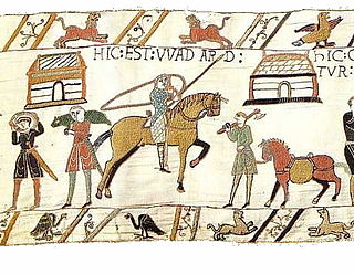
Wadard was an 11th-century Norman nobleman who is mentioned in the Domesday Book of 1086, and is depicted in the Bayeux Tapestry.


