
Stanford in the Vale is a village and civil parish in the Vale of White Horse about 3+1⁄2 miles (5.6 km) southeast of Faringdon and 5 miles (8 km) northwest of Wantage. It is part of the historic county of Berkshire, however since 1974, it has been administered as a part of Oxfordshire. The 2011 Census recorded the parish's population 2,093.
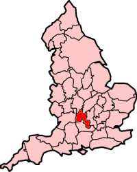
The county of Oxfordshire in England is broadly situated in the land between the River Thames to the south, the Cotswolds to the west, the Chilterns to the east and The Midlands to the north, with spurs running south to Henley-on-Thames and north to Banbury.

Alvescot is a village and civil parish about 1+1⁄2 miles (2.4 km) south of Carterton, Oxfordshire, England. The 2011 Census recorded the parish's population as 472.

Asthall or Asthal is a village and civil parish on the River Windrush in the West Oxfordshire district, in Oxfordshire, about 6 miles (10 km) west of Witney. It includes the hamlets of Asthall Leigh, Field Assarts, Stonelands, Worsham and part of Fordwells. The 2011 Census recorded the parish's population as 252. Asthall village is just south of the River Windrush, which also forms the south-eastern part of its boundary. The remainder of the parish including all of its hamlets lie north of the river. A minor road through Fordwells forms most of the parish's northern boundary. Most of the remainder of the parish's boundary is formed by field boundaries.

Begbroke is a village and civil parish in Oxfordshire about one mile (1.6 km) west of Kidlington and five miles (8 km) northwest of Oxford. The 2011 Census recorded the parish's population as 783.

Black Bourton is a village and civil parish about 2 miles (3 km) south of Carterton, Oxfordshire. The village is on Black Bourton Brook, a tributary of the River Thames. The 2011 Census recorded the parish population as 266. RAF Brize Norton adjoins the parish. The northern boundary of the parish is along the middle of the main runway of the airfield.

Standlake is a village and civil parish in West Oxfordshire about 5 miles (8 km) southeast of Witney and 7 miles (11 km) west of Oxford, England. The parish includes the hamlet of Brighthampton. The 2011 Census recorded the parish's population as 1,497. The River Windrush flows past the village and with its tributary Medley Brook it forms much of the eastern boundary of the parish. The western boundary has been subject to changes and disputes in past centuries. It now follows Brighthampton Cut, an artificial land drain dug in the 19th century. The Windrush joins the River Thames at Newbridge just over 1 mile (1.6 km) to the south.south.

Bix is a village in the civil parish of Bix and Assendon in South Oxfordshire, about 2.5 miles (4 km) northwest of Henley-on-Thames. The village is about 130 metres (430 ft) above sea level in the Chiltern Hills.

William Turner was a British painter who specialised in watercolour landscapes. He is often known as William Turner of Oxford or just Turner of Oxford to distinguish him from his contemporary, J. M. W. Turner. Many of Turner's paintings depicted the countryside around Oxford. One of his best known pictures is a view of the city of Oxford from Hinksey Hill.

Eynsham Abbey was a Benedictine monastery in Eynsham, Oxfordshire, in England between 1005 and 1538. King Æthelred allowed Æthelmær the Stout to found the abbey in 1005. There is some evidence that the abbey was built on the site of an earlier minster, probably founded in the 7th or 8th centuries. The site is a Scheduled Historic Monument.
Brighthampton is a hamlet which is contiguous with the village of Standlake, about 4 miles (6.4 km) south of Witney, in West Oxfordshire, in the county of Oxfordshire, England.
Lewknor is a village and civil parish about 5 miles (8 km) south of Thame in Oxfordshire. The civil parish includes the villages of Postcombe and South Weston. The 2011 Census recorded the parish's population as 663.

Somerton is a village and civil parish in Oxfordshire, England, in the Cherwell valley about 6 miles (10 km) northwest of Bicester. The 2011 Census recorded the parish's population as 305.

Widford is a deserted medieval village in the civil parish of Swinbrook and Widford, in the West Oxfordshire district, in the county of Oxfordshire, England. It is on the River Windrush about 1.5 miles (2.4 km) east of Burford. The village was an exclave of Gloucestershire until 1844.

Minster Lovell Hall is a ruin in Minster Lovell, an English village in the Oxfordshire Cotswolds. The ruins are situated by the River Windrush.

Hailey is a village and civil parish about 2 miles (3 km) north of Witney, Oxfordshire. The village comprises three neighbourhoods: Middletown on the main road between Witney and Charlbury, Poffley End on the minor road to Ramsden and Delly End on Whiting's Lane. The parish extends from the River Windrush in the south, almost to the village of Ramsden and the hamlet of Wilcote in the north, and it includes the hamlet of New Yatt. The 2011 Census recorded the parish's population as 1,208.
Crawley is a village and civil parish beside the River Windrush about 2+1⁄2 miles (4 km) north of Witney, Oxfordshire. The parish extends from the Windrush in the south almost to village of Leafield in the northwest. The 2011 Census recorded the parish's population as 155.

Kencot is a village and civil parish about 2 miles (3 km) south-west of Carterton in West Oxfordshire. The 2011 Census recorded the parish's population as 101.
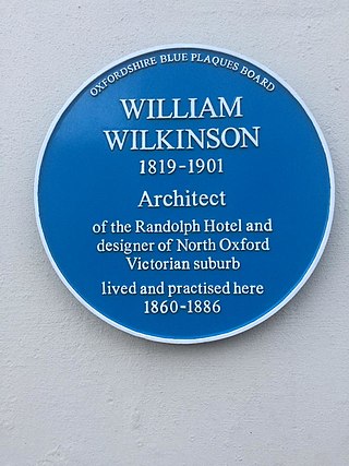
William Wilkinson (1819–1901) was a British Gothic Revival architect who practised in Oxford, England.
Minster Lovell Priory was a priory in Minster Lovell, Oxfordshire, England. Its current site is lost, though it is thought to have been west of St Kenelm's parish church and Minster Lovell Hall.


