
Cooper City is a city in Broward County, Florida, United States. The city is named for Morris Cooper, who founded the community in 1959. The city's population was 28,547 at the 2010 census. Cooper City is part of the Miami metropolitan area, which was home to an estimated 6,012,331 people in 2015.
Casselberry is a city in Seminole County, Florida, United States. The population was 26,241 at the 2010 census. The city is usually considered linked to the Orlando–Kissimmee–Sanford Metropolitan Statistical Area.

Palos Park is a village in southwestern Cook County, Illinois, United States. The population was 4,847 at the 2010 census.

Worth is a village in Cook County, Illinois, United States, a suburb of Chicago. The population was 10,789 at the 2010 census.

Lake Grove is a village in Suffolk County, New York, United States. The population was 11,163 at the 2010 census. The village is located in the town of Brookhaven. The village is officially known as the Incorporated Village of Lake Grove.

Rye Brook is a village in Westchester County, New York, United States, within the town of Rye. The population was 9,347 at the 2010 census.

Englewood is a city in Montgomery County, Ohio, United States and a northern suburb of Dayton. The population was 13,465 at the 2010 census. It is part of the Dayton Metropolitan Statistical Area.

Tidioute is a borough in Warren County, Pennsylvania, United States. The population was 792 at the 2000 census.

Shoreline is a city in King County, Washington, United States, 9 miles (14 km) north of Downtown Seattle bordering the northern Seattle city limits. As of the 2010 census, the population was 53,007, making it the 20th largest city in the state of Washington.
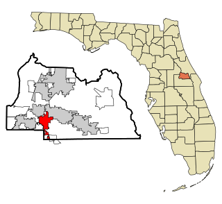
Pine Island is a city in Goodhue and Olmsted counties in the U.S. state of Minnesota. Most of Pine Island is located within Goodhue County, but a small part extends into Olmsted County, making that small portion part of the Rochester metropolitan area. The city's population was 3,263 at the 2010 census.

Sturgis is a town of 620 people in east central Saskatchewan, Canada. The Town of Sturgis is 95 km north of Yorkton on Highway 9. It is located in the Assiniboine river valley near the lakes and woods region of the province.

Cokethorpe School is an independent school at Hardwick, West Oxfordshire, about 2.5 miles (4 km) south of Witney. It was founded in 1957 by Francis Brown. It is a member of HMC, IAPS and The Society of Heads. The school has about 660 pupils, ranging in age from four to 18. The Junior School and the Senior School are on the same site.
Little Mill is a village in Monmouthshire, south east Wales, United Kingdom. The village has grown in size in recent years and has as a result a population of over 1,000.

Pleasant Ridge is an unincorporated community in northern Barry County, Missouri, United States. It is located on Missouri Supplemental Routes Z and VV, eight miles east of Monett. Community boundaries extend approximately 0.5 mile east and west of Route VV along Route Z, and 0.5 to 1 mile north and south of Route Z along Routes VV and its farm road extension to the north.

MacEwan Glen is a suburban neighbourhood in northwest Calgary, Alberta, Canada. The primarily low-density residential community is located directly north of Nose Hill Park and is bounded by Country Hills Boulevard to the north, 14 Street W to the east, Shaganappi Trail to the west, and Nose Hill to the south.

York Township is one of nine townships in DuPage County, Illinois, USA. As of the 2010 census, its population was 123,449 and it contained 51,557 housing units.

Highland Park is a residential neighbourhood in the north-west quadrant of Calgary, Alberta. It is bounded to the north by McKnight Boulevard, to the east by Edmonton Trail, to the south by 32 Avenue N and to the west by 4 Street W. Confederation Park and Nose Hill Park are located in close proximity. The Queens Park Cemetery occupies the south-western corner of the neighbourhood, and the Highland golf course is developed in the north.

Brooklyn is a village in Dane and Green Counties in the U.S. state of Wisconsin. At the 2000 census, 502 Brooklyn residents lived in Dane County and 414 in Green County, with a total population of 916. The 2010 census population was 1,401 inhabitants, with 936 of these in Dane County and 465 in Green County.


