
The Cotswolds is a region in central-southwest England, along a range of rolling hills that rise from the meadows of the upper Thames to an escarpment above the Severn Valley and Evesham Vale.

Oxfordshire is a historic, ceremonial and non-metropolitan county in South East England. It is a mainly rural county, with its largest settlement being the city of Oxford. The county is a centre of research and development, primarily due to the work of the University of Oxford. Oxfordshire is locally governed by Oxfordshire County Council, together with the lower tier councils of its five non-metropolitan districts: City of Oxford, Cherwell, South Oxfordshire, Vale of White Horse, and West Oxfordshire. The ceremonial county is landlocked and bordered by Northamptonshire to the north-east, Warwickshire to the north-west, Buckinghamshire to the east, Berkshire to the south, Wiltshire to the south-west, and Gloucestershire to the west. The areas of Oxfordshire south of the River Thames were part of the historic county of Berkshire, including the county's highest point, the 261-metre (856 ft) White Horse Hill.
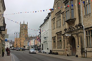
Cotswold is a local government district in Gloucestershire, England. It is named after the wider Cotswolds region. Its main town is Cirencester. Other notable towns include Tetbury, Moreton-in-Marsh, Stow-on-the-Wold and Chipping Campden. Notable villages in the district include Bourton-on-the-Water, Blockley, Kemble and Upper Rissington among other villages and hamlets in the district. Cotswold District Council is composed of 34 councillors elected from 32 wards.

West Oxfordshire is a local government district in northwest Oxfordshire, England, including towns such as Woodstock, Burford, Chipping Norton, Charlbury, Carterton and Witney, where the council is based.
Charlbury is a town and civil parish in the Evenlode valley, about 6 miles (10 km) north of Witney in the West Oxfordshire district of Oxfordshire, England. It is on the edge of Wychwood Forest and the Cotswolds. The 2011 Census recorded the parish's population as 2,830.

Woodstock is a market town and civil parish, 8 miles (13 km) north-west of Oxford in West Oxfordshire in the county of Oxfordshire, England. The 2011 Census recorded a parish population of 3,100.
Combe is a village and civil parish about 5 miles (8 km) northeast of Witney in Oxfordshire. It is bounded to the south and southwest by the River Evenlode, to the northwest partly by the course of the Akeman Street Roman road and partly by a road parallel with it, and to the east by the boundary of Blenheim Great Park. The 2011 Census recorded the parish's population as 768.

The Cotswold Line is an 86+1⁄2-mile (139.2 km) railway line between Oxford and Hereford in England.

The River Leach is a river tributary to the River Thames, in England which runs mostly in Gloucestershire. It is approximately 18 miles (29 km) long, springing from the limestone uplands of the Cotswolds. In parts of its course it becomes a seasonal bourn, only running above ground when there is sufficient rainfall. Despite its small size it gives its name to two towns and a pair of villages.

Witney is a county constituency in Oxfordshire represented in the House of Commons of the Parliament of the United Kingdom. It elects one Member of Parliament by the first-past-the-post system of election, and was created for the 1983 general election. It has been a safe Conservative Party seat at recent elections. It is currently represented by Robert Courts of the Conservative Party.

Bledington is a village and civil parish in the Cotswold district of Gloucestershire, England, about four miles southeast of Stow-on-the-Wold and six miles southwest of Chipping Norton. The population of the civil parish in 2014 was estimated to be 490.

Shipton-under-Wychwood is an English village and civil parish in the Evenlode valley about 4 miles (6.4 km) north of Burford, Oxfordshire. The village is one of three named after the ancient forest of Wychwood. The others are Milton-under-Wychwood immediately to the west of the village and Ascott-under-Wychwood about 1.5 miles (2.4 km) to the east. The 2011 Census recorded Shipton-under-Wychwood's parish population as 1,244.

King's Lock is a lock on the River Thames in England. It is in open country to the north of Oxford, Oxfordshire, on the southern bank of the river. The lock was one of the last pound locks built on the Thames, built by the Thames Conservancy in 1928 to replace the former flash lock. It has the smallest fall of any lock on the river, 0.77 m.
Finstock is a village and civil parish about 2 miles (3 km) south of Charlbury in Oxfordshire, England. The parish is bounded to the northeast by the River Evenlode, to the southeast partly by the course of Akeman Street Roman road, and on other sides by field boundaries. The 2011 Census recorded the parish's population as 797. For most of its history Finstock was a township of the ancient parish of Charlbury. Finstock became a separate civil parish in the late 19th century.
The Oxfordshire Way is a long-distance walk in Oxfordshire, England, with 6 miles in Gloucestershire and very short sections in Buckinghamshire. The path links with the Heart of England Way and the Thames Path.
Fawler is a hamlet and civil parish in the valley of the River Evenlode, 1.5 miles (2.4 km) southeast of Charlbury in Oxfordshire, England. There are traces of a Roman villa at Oatlands Farm. The manor house was built in 1660. Finstock railway station on the Cotswold Line is closer to Fawler than to Finstock.

The River Glyme is a river in Oxfordshire, England. It is a tributary of the River Evenlode. It rises about 1 mile (1.6 km) east of Chipping Norton, and flows southeast past Old Chalford, Enstone, Kiddington, Glympton and Wootton, Woodstock and through Blenheim Park. At Wootton the Glyme is joined by a tributary, the River Dorn. The Glyme joins the Evenlode just south of the park near Bladon.
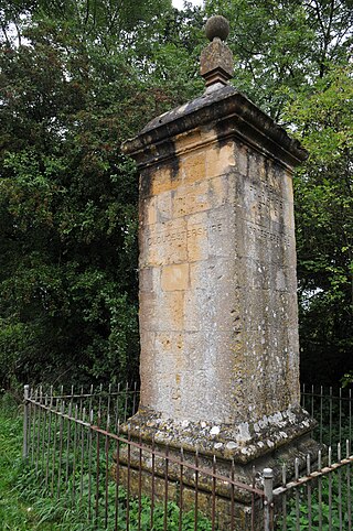
The Four Shire Stone is a boundary marker that marks the place where the four historic English counties of Warwickshire, Oxfordshire, Gloucestershire, and Worcestershire once met. Since 1931, with a change to the boundaries of Worcestershire, only three of the counties meet at the stone.
The Cassington Canal was an early 19th-century canal near Eynsham, Oxfordshire. The canal was built by the 4th Duke of Marlborough to provide a link between the River Thames and Cassington Mill; it later provided alternative wharfage to that at Eynsham. The 0.75-mile (1.21 km) canal was in operation for less than 70 years, its use declining with the advent of rail transport.
