Chepstow East railway station

Last updated

Chepstow East
General information
Location Tutshill, nr Chepstow, Forest of Dean
England
Grid reference ST553948
Other information
StatusDisused
History
Original company South Wales Railway
Key dates
19 September 1851Station opened
19 July 1852Station closed
South Wales Railway
BSicon CONTg@G.svg
BSicon lCONTg@F.svg
BSicon STR.svg
BSicon eABZg+l.svg
BSicon exCONTfq.svg
to docks and GRC&W Works
BSicon ABZgl+l.svg
BSicon ABZrx2.svg
BSicon exSTRc3.svg
BSicon STR.svg
BSicon exSTRc1.svg
BSicon exABZ+4l.svg
BSicon exSTR+r.svg
BSicon ABZ2xl.svg
BSicon STRc3.svg
BSicon exBHFq.svg
BSicon exABZqr.svg
BSicon exABZgr+r.svg
Gloucester Eastgate
BSicon STRc1.svg
BSicon STR+4.svg
BSicon exDST.svg
Gloucester Docks
BSicon BHF.svg
BSicon exSTRc2.svg
BSicon exSTR3.svg
Gloucester
(GWR)
BSicon dWASSERq.svg
BSicon exSTRc2.svg
BSicon hKRZWae.svg
BSicon lMKRZq3+1u.svg
BSicon exSTR3+1.svg
BSicon WASSERq.svg
BSicon exdSTRc4.svg
BSicon dWASSERq.svg
BSicon eABZg+1.svg
BSicon exSTRc4.svg
BSicon dWASSERq.svg
BSicon hKRZWae.svg
BSicon dWASSERq.svg
BSicon exCONTgq.svg
BSicon eABZgr.svg
BSicon eHST.svg
Oakle Street
BSicon eHST.svg
Grange Court
BSicon exCONTgq.svg
BSicon eABZgr.svg
BSicon eHST.svg
Westbury-on-Severn Halt
BSicon eHST.svg
Newnham
BSicon TUNNEL1.svg
BSicon eHST.svg
Ruddle Road Halt
BSicon exdCONTgq.svg
BSicon STR~L.svg
BSicon exSTR+r.svg
BSicon STR~R.svg
BSicon exlvDST.svg
BSicon exdKDSTe.svg
BSicon edDST-R.svg
Bullo Pill
(Goods only)
BSicon eHST.svg
Awre for Blakeney
BSicon exCONTgq.svg
BSicon eABZgr.svg
BSicon eHST.svg
Gatcombe
BSicon STR.svg
BSicon exSTRc2.svg
BSicon exCONT3.svg
BSicon eSTR+c2.svg
BSicon exhKRXWaeq.svg
BSicon exSTRc4.svg
BSicon exSTRc2.svg
BSicon eKRZ3+1u.svg
BSicon exSTRc4.svg
BSicon extSTRc2.svg
BSicon exlv-HST@G.svg
BSicon extSTR3+1a@f.svg
BSicon eSTR+c4.svg
Severn Bridge
BSicon extSTR+1.svg
BSicon extSTRc4.svg
BSicon STRc2.svg
BSicon ABZg3.svg
Severn Bridge Tunnel
BSicon exBS2l.svg
BSicon PORTALg.svg
BSicon exSTRl.svg
BSicon exBS2c3.svg
BSicon ABZ1+fxr.svg
BSicon STRc4.svg
BSicon BHF.svg
Lydney Gnome-searchtool.svg
BSicon vKBHFxa-BHF.svg
BSicon v-STR.svg
Lydney Junction BSicon lDAMPF.svg
BSicon BS2c1.svg
BSicon eABZg+l.svg
BSicon SHI2g+r.svg
BSicon eKRZ.svg
BSicon exCONTfq.svg
BSicon CONTgq.svg
BSicon xABZgr.svg
BSicon STR.svg
BSicon exCONTgq.svg
BSicon exSTRr.svg
BSicon STR.svg
Tinworks branch
BSicon eHST.svg
Woolaston
BSicon exCONTgq.svg
BSicon eABZg+r.svg
BSicon eHST.svg
Tutshill for Beachley Halt
BSicon eHST.svg
Chepstow East
BSicon dWASSERq.svg
BSicon hKRZWae.svg
BSicon dWASSERq.svg
Chepstow Railway Bridge
over River Wye
BSicon BHF.svg
Chepstow
BSicon exdSTRc2.svg
BSicon dSTR.svg
BSicon exCONT3.svg
BSicon edHST.svg
BSicon exdSTR+1.svg
BSicon exSTRc4.svg
Portskewett (original location)
("Portskewett Junction" 1863–1886)
BSicon edHST.svg
Portskewett
BSicon tSTRc2.svg
BSicon vSTR-.svg
BSicon t-STR3+l.svg
BSicon t-CONTfq.svg
BSicon KBSTaq.svg
BSicon v-STR+r.svg
BSicon tdSTR+1.svg
BSicon dSTR.svg
BSicon tdSTRc4.svg
Caerwent Training Area
BSicon tdSTRe.svg
BSicon vSTR-.svg
BSicon v-STR2.svg
BSicon dSTRc3.svg
BSicon dHST.svg
Caldicot
BSicon STRc1.svg
BSicon dHST.svg
BSicon dSTR+4.svg
Severn Tunnel Junction
BSicon eHST.svg
Undy Halt
BSicon eHST.svg
Magor
BSicon SPLa.svg
BSicon vUWBl.svg
flying junction
BSicon SPLe.svg
BSicon BUE.svg
Bishton Crossing
BSicon vSHI2gl-.svg
BSicon edHST.svg
BSicon dBST.svg
Llanwern
station & steelworks
BSicon vSHI2g+l-.svg
BSicon ABZg+l.svg
BSicon CONTfq.svg
Goods line to Uskmouth
BSicon CONTgq.svg
BSicon ABZgr+r.svg
BSicon dWASSERq.svg
BSicon hKRZWae.svg
BSicon dWASSERq.svg
BSicon BHF.svg
Newport High Street
BSicon CONTg.svg
BSicon TUNNEL1.svg
BSicon ABZl+l.svg
BSicon STRq.svg
BSicon ABZglr+r.svg
BSicon KDSTeq.svg
Alexandra Dock
BSicon CONTf.svg
BSicon UST.svg
BSicon eHST.svg
Marshfield
BSicon dWASSERq.svg
BSicon WBRUCKE1.svg
BSicon dWASSERq.svg
BSicon eHST.svg
Roath
BSicon CONTg.svg
BSicon STR.svg
BSicon ABZl+l.svg
BSicon BHFq.svg
BSicon KRZu.svg
BSicon STR+r.svg
Cardiff Queen Street
BSicon CONTf.svg
BSicon STRc2.svg
BSicon ABZ3+gl.svg
BSicon ABZgr.svg
BSicon BHF+1.svg
BSicon STRc4.svg
BSicon STR.svg
Cardiff Central
BSicon hKRZWae.svg
BSicon KHSTxe.svg
Bute Street
BSicon ABZg2.svg
BSicon STRc3.svg
BSicon exKDSTe.svg
Queen Alexandra Dock
BSicon STR+c1.svg
BSicon STR+4.svg
BSicon BOOT.svg
P & A Campbell ferry
across the River Severn
BSicon STR.svg
BSicon ABZgl+l.svg
BSicon ABZq+rxl.svg
BSicon LSTR+r.svg
BSicon STR.svg
BSicon DST.svg
BSicon STR.svg
BSicon LSTRe.svg
BSicon KRWg+l.svg
BSicon STRc2.svg
BSicon KRWr.svg
BSicon HST3.svg
Ninian Park
BSicon STRc2.svg
BSicon ABZg+l.svg
BSicon ABZ1+3r.svg
BSicon STRc4.svg
Leckwith Junction
BSicon CONTgq.svg
BSicon KRZr+1u.svg
BSicon STRc4.svg
BSicon eHST2.svg
BSicon STRc3.svg
Ely Main Line
BSicon STRc1.svg
BSicon eHST+4.svg
St Fagans
BSicon ekABZg3.svg
BSicon LSTRa.svg
St Fagans Junction
BSicon exCONTgq.svg
BSicon exkABZq1.svg
BSicon exkSTRc2.svg
BSicon exkSTRc4.svg
BSicon eKRZu.svg
BSicon exkABZq+3.svg
BSicon LSTR.svg
BSicon exLSTRr.svg
Barry Railway
to Barry Arrow Blue Up 001.svg
Arrow Blue Left 001.svg to Tynycaeau Junction
BSicon ekABZg+1.svg
BSicon LSTRe.svg
Drope Junction
BSicon eHST.svg
Peterston
BSicon HST.svg
Pontyclun
BSicon exCONTgq.svg
BSicon eABZgr.svg
BSicon eABZgl.svg
BSicon exCONTfq.svg
BSicon HST.svg
Llanharan
BSicon exCONTgq.svg
BSicon eABZgr.svg
BSicon HST.svg
BSicon LSTRa.svg
Pencoed
BSicon ABZg+l.svg
BSicon STRq.svg
BSicon LSTRr.svg
BSicon BHF.svg
Bridgend
BSicon CONTgq.svg
BSicon ABZgr.svg
BSicon exCONT3+l.svg
BSicon eKRZo.svg
BSicon exSTR+r.svg
BSicon eKRWg+l.svg
BSicon exKRWgr.svg
Pyle Junction
BSicon HST.svg
BSicon exSTR.svg
Pyle
BSicon eABZg+l.svg
BSicon exABZql.svg
BSicon exCONTfq.svg
BSicon CONT4+l.svg
BSicon KRZo.svg
BSicon STR+r.svg
BSicon exCONTgq.svg
BSicon eKRZo.svg
BSicon eABZgr.svg
BSicon KRWg+l.svg
BSicon xKRWgr.svg
Junction (Mean)
BSicon eHST.svg
BSicon exSTR.svg
Margam Halt
BSicon HST.svg
BSicon exSTR.svg
Port Talbot
BSicon eABZgl.svg
BSicon exABZql.svg
BSicon exKDSTeq.svg
Port Talbot Docks
BSicon HST.svg
Baglan
BSicon eKRWgl.svg
BSicon exKRW+r.svg
BSicon exCONTgq.svg
BSicon eKRZu.svg
BSicon exABZgr+r.svg
BSicon exCONTgq.svg
BSicon eKRZu.svg
BSicon exABZgr+r.svg
BSicon HST.svg
BSicon exDST.svg
Briton Ferry
BSicon ABZgl.svg
BSicon eABZqr+l.svg
BSicon CONTfq.svg
BSicon HST.svg
BSicon exSTR.svg
Neath
BSicon exCONTgq.svg
BSicon exSTRc2.svg
BSicon eABZgr.svg
BSicon exSTR3.svg
BSicon eABZg+1.svg
BSicon exSTRc4.svg
BSicon dWASSERq.svg
BSicon hKRZWae.svg
BSicon dWASSERq.svg
BSicon HST.svg
Skewen
BSicon exCONTgq.svg
BSicon eABZgr.svg
BSicon eABZgl+l.svg
BSicon exCONTfq.svg
BSicon HST.svg
Llansamlet
BSicon dWASSERq.svg
BSicon hKRZWae.svg
BSicon dWASSERq.svg
Landore viaduct
over River Tawe
BSicon eHST.svg
Landore High Level
BSicon ABZgl+l.svg
BSicon KBHFeq.svg
Swansea
BSicon TUNNEL1.svg
BSicon eHST.svg
Cockett
BSicon HST.svg
Gowerton North
BSicon eHST.svg
Loughor
BSicon dWASSERq.svg
BSicon hKRZWae.svg
BSicon dWASSERq.svg
BSicon exCONTgq.svg
BSicon eABZglr.svg
BSicon exKBSTeq.svg
Trostre Tinplate Works
BSicon BHF.svg
Llanelli
BSicon HST.svg
Pembrey & Burry Port
BSicon eHST.svg
Lando Platform
BSicon eHST.svg
Kidwelly Flats Halt
BSicon HST.svg
Kidwelly
BSicon HST.svg
Ferryside
BSicon eBHF.svg
Carmarthen Junction
BSicon exCONTgq.svg
BSicon KBHFxaq.svg
BSicon ABZgr+r.svg
Carmarthen
for Carmarthen–Aberystwyth line via Lampeter
BSicon eHST.svg
Sarnau
BSicon eHST.svg
St Clears
BSicon BHF.svg
Whitland
BSicon ABZgl.svg
BSicon CONTfq.svg
BSicon exCONTgq.svg
BSicon eABZgr.svg
BSicon pHST.svg
Clunderwen
BSicon exLSTR+l.svg
BSicon exSTRq.svg
BSicon eABZgr.svg
Rosebush loop
BSicon exLSTRe.svg
BSicon pHST.svg
Clarbeston Road
BSicon KRW+l.svg
BSicon KRWgr.svg
Fishguard branch
BSicon STR.svg
BSicon BHF.svg
Haverfordwest
BSicon eHST.svg
BSicon STR.svg
Wolf's Castle Halt
BSicon eHST.svg
BSicon STR.svg
Welsh Hook Halt
BSicon exLSTRa.svg
BSicon eHST.svg
BSicon STR.svg
Mathry Road
BSicon exLKRWl.svg
BSicon eKRWg+r.svg
BSicon STR.svg
Rosebush loop
BSicon eHST.svg
BSicon STR.svg
Jordanston Halt
BSicon HST.svg
BSicon STR.svg
Fishguard & Goodwick
BSicon KBHFe.svg
BSicon STR.svg
Fishguard Harbour
BSicon BOOT.svg
BSicon STR.svg
BSicon pHST.svg
Johnston
BSicon eABZgl.svg
BSicon exKBHFeq.svg
Neyland
BSicon ABZgl.svg
BSicon KBSTeq.svg
Waterston oil refinery
BSicon KBSTaq.svg
BSicon ABZgr.svg
Robeston oil refinery
BSicon KBHFxe.svg
Milford Haven
BSicon exABZgl.svg
BSicon exKDSTeq.svg
Newton Noyes
BSicon exKBHFe.svg
Hakin Docks

Chepstow East railway station was a temporary station on the South Wales Railway (now the Gloucester to Newport Line). It was on the opposite bank of the River Wye from Chepstow and was only used for a few months until the river was crossed by a railway bridge. This was about a mile from Chepstow railway station, [lower-roman 1] at the road bridge close to the future junction of the Wye Valley line [1] (which opened in November 1876). [2] It was opened on 19 September 1851 and served as a temporary station while the Chepstow railway bridge was being constructed across the river to link up with the rest of the line. It closed on 19 July 1852, the day that the bridge over the Wye was opened. [3] [4]

Another station, Tutshill for Beachley Halt was opened in 1934 at a close location.

Preceding station Historical railways Following station
Terminus  South Wales Railway   Woolaston
Line open, station closed

Related Research Articles

<span class="mw-page-title-main">Royal Oak tube station</span> London Underground station

Royal Oak is a station of the London Underground, on the Hammersmith & City and Circle lines, between Westbourne Park and Paddington stations. The station is on Lord Hill's Bridge and is in Travelcard Zone 2 for the London Underground. Although not heavily used at other times, the station is extremely busy during the annual Notting Hill Carnival. There is no wheelchair access to the platform. It is classed as a "local station" in Transport for London's "Fit for the Future" development outline.

<span class="mw-page-title-main">Pangbourne railway station</span> Railway station in the village of Pangbourne, Berkshire, England

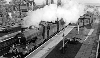
Pangbourne railway station serves the village of Pangbourne in the county of Berkshire, and across the River Thames the village of Whitchurch-on-Thames, in Oxfordshire. It is 41 miles 43 chains (66.8 km) down the line from London Paddington and is situated between Tilehurst to the east and Goring & Streatley to the west. The station is served by local services operated by Great Western Railway.

<span class="mw-page-title-main">Goring & Streatley railway station</span> Railway station serving the villages of Goring-on-Thames and Streatley in England

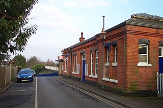
Goring & Streatley railway station is on the Great Western Main Line serving the twin villages of Goring-on-Thames, Oxfordshire and Streatley, Berkshire in England. The station is in Goring-on-Thames, adjacent to the village centre and some five minutes walk from Goring and Streatley Bridge, which connects the village with Streatley, across the River Thames. It is 44 miles 60 chains (72.0 km) down the line from London Paddington and is situated between Pangbourne to the east and Cholsey to the west. It is served by local services operated by Great Western Railway (GWR).

<span class="mw-page-title-main">Taplow railway station</span> Railway station serving the village of Taplow, Buckinghamshire, England

Taplow railway station serves the village of Taplow in Buckinghamshire, England. It is 22 miles 39 chains (36.2 km) down the line from London Paddington and is situated between Burnham to the east and Maidenhead to the west.

<span class="mw-page-title-main">Chepstow Railway Bridge</span> Bridge spanning the River Wye between England and Wales

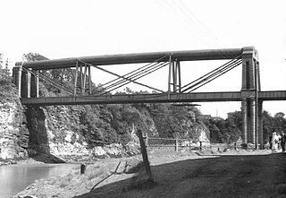
Chepstow Railway Bridge was built to the instructions of Isambard Kingdom Brunel in 1852. The "Great Tubular Bridge" over the River Wye at Chepstow, which at that point forms the boundary between Wales and England, is considered one of Brunel's major achievements, despite its appearance. It was economical in its use of materials, and would prove to be the design prototype for Brunel's Royal Albert Bridge at Saltash. Although the superstructure has since been replaced, Brunel's tubular iron supports are still in place. It is a Grade II listed structure.

<span class="mw-page-title-main">Pontyclun railway station</span> Railway station in Rhonda Cynon Taff, Wales

Pontyclun railway station is an unstaffed, minor railway station in Pontyclun, in the County Borough of Rhondda Cynon Taf, South Wales. The station is at street level, on Station Approach, Pontyclun. It is a stop on the South Wales Main Line, served by trains on the Maesteg Line, and occasionally by the Swanline Cardiff to Swansea regional services, as well as one early-morning daily service to Manchester and a late-night daily service to Carmarthen. The station and all trains are operated by Transport for Wales Rail.

<span class="mw-page-title-main">Churchdown railway station</span> Former railway station in England

Churchdown railway station was situated on the main line between Gloucester and Cheltenham Spa. It served Churchdown and surrounding areas.

<span class="mw-page-title-main">Berkeley railway station</span> Disused railway station in Berkeley, Gloucestershire, England

Berkeley railway station served the town of Berkeley in Gloucestershire, England. The station was on the Sharpness Branch Line, part of the Midland Railway (MR), which connected the Bristol and Gloucester Railway main line at Berkeley Road station with the docks at Sharpness.

<span class="mw-page-title-main">Ross and Monmouth Railway</span>

The Ross and Monmouth Railway was a standard gauge railway of 13 miles (21 km) which ran between Ross-on-Wye, in Herefordshire, England and Monmouth, Wales.

<span class="mw-page-title-main">Moulsford railway station</span> Former railway station in England

Moulsford railway station was on the original route of the Great Western Railway, being one of three intermediate stations provided when the line was extended from Reading to Steventon in 1840.

Hinksey Halt railway station was built by the Great Western Railway to serve New Hinksey, a suburb of Oxford.

<span class="mw-page-title-main">Newnham railway station</span> Former railway station in England

Newnham railway station was a station serving the village of Newnham on Severn, Gloucestershire.

<span class="mw-page-title-main">Tetbury Road railway station</span> Former railway station in England

Tetbury Road railway station was built by the Cheltenham & Great Western Union Railway to serve the Gloucestershire villages of Kemble and Coates, and the town of Tetbury.

<span class="mw-page-title-main">Savernake Low Level railway station</span> Former railway station in England

Savernake Low Level railway station was a station on the Berks and Hants Extension Railway, near the village of Burbage in Wiltshire, England. It was open from 1862 until 1966.

<span class="mw-page-title-main">Neyland railway station</span> Former railway station in Wales

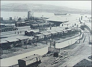
Neyland railway station was on the north bank of the Milford Haven Waterway in Pembrokeshire, Wales.

<span class="mw-page-title-main">Chalford railway station</span> Former railway station in England

Chalford railway station was situated on the Great Western Railway's Golden Valley Line, between Swindon and Gloucester. It was just east of the bridge carrying Cowcombe Hill over the railway. To the east of the station site lies Chalford Viaduct, and beyond that, Sapperton Long Tunnel.

The Clarbeston Road and Letterston Railway was a small railway company formed to give the Great Western Railway a more direct route to the port at Fishguard Harbour.

<span class="mw-page-title-main">Chalvey Halt railway station</span> Former railway station in England

Chalvey Halt was a short-lived railway station on the Great Western Railway branch from Slough to Windsor & Eton. It was situated just to the north of the bridge carrying the railway over Chalvey Road in Chalvey, south-western Slough, England. It was open for just fourteen months.

<span class="mw-page-title-main">Bathampton railway station</span> Disused railway station in Bathampton, Somerset

Bathampton railway station is a former railway station in Bath, UK, serving the community of Bathampton. The station opened on 2 February 1857 and closed on 3 October 1966. Very little remains, as the station site was replaced with improved trackwork for a nearby junction. The only significant remains are the gateposts at the head of the approach road.

<span class="mw-page-title-main">Kidwelly Flats Halt railway station</span> Former railway station in Wales

Kidwelly Flats Halt railway station served the Royal Ordnance Factory (ROF) and RAF Pembrey at Pembrey, Carmarthenshire, Wales between 1941 and 1957. It was on the West Wales Line.

References

  1. By road, across the Wye Bridge. There was no more direct route at this time.
  1. MacDermot, E.T. (1927). History of the Great Western Railway, vol. I: 1833-1863. Paddington: Great Western Railway. p. 567.
  2. MacDermot, E.T. (1931). History of the Great Western Railway, vol. II: 1863-1921. Paddington: Great Western Railway. p. 602.
  3. Butt, R.V.J. (1995). The Directory of Railway Stations. Yeovil: Patrick Stephens Ltd. p. 59. ISBN   1-85260-508-1. R508.
  4. MacDermot (1927), p. 569.

Coordinates: 51°38′39″N2°39′55″W / 51.6443°N 2.6653°W / 51.6443; -2.6653