Nailsworth Stream

Last updated

Nailsworth Stream
Naisworth Stream by Wyevale Garden Centre - geograph.org.uk - 1713590.jpg
Nailsworth Stream by Wyevale Garden Centre
Gloucestershire UK relief location map.jpg
Red pog.svg
Location within Gloucestershire
Location
Country England
Counties Gloucestershire
Physical characteristics
Source 
  locationCherington
  coordinates 51°41′18″N2°08′33″W / 51.6884°N 2.1425°W / 51.6884; -2.1425 (Cherington)
Mouth  
  location
River Frome
  coordinates
51°44′22″N2°14′31″W / 51.7395°N 2.2419°W / 51.7395; -2.2419 (River Frome) Coordinates: 51°44′22″N2°14′31″W / 51.7395°N 2.2419°W / 51.7395; -2.2419 (River Frome)
Nailsworth Stream
BSicon uexCONTgq.svg
BSicon uexABZq+r.svg
BSicon uexCONTfq.svg
River Frome
BSicon uexSKRZ-Au.svg
A419 Dudbridge Bypass Bridge
BSicon uxSTRbr.svg
Flour Mill
BSicon uexSKRZ-Eu.svg
Sainsbury's access bridge
BSicon uextSTRa.svg
culvert under Selsey Hill ...
BSicon uextSTRe.svg
... and Dudbridge Meadow
BSicon uxSTRbr.svg
Lightpill Mill
BSicon uexSKRZ-Eu.svg
bridge
BSicon uxSTRbr.svg
Mill at Rooksmoor
BSicon uexSKRZ-Yu.svg
Selsey Road bridge
BSicon uexSKRZ-Eu.svg
Pauls Rise bridge
BSicon uxSTRbl.svg
Churches Mill
BSicon uexSKRZ-Eu.svg
Station Road Woodchester
BSicon uxSTRbr.svg
Frogmarsh Mill
BSicon uexSKRZ-Au.svg
A46 Stroud Road Bridge
BSicon uxSTRbr.svg
Merrett's Mill
BSicon uexSKRZ-Yu.svg
Giddynap Lane bridge
BSicon uexSTRl.svg
BSicon uexSTR+r.svg
BSicon uexSTR+l.svg
BSicon utABZgr.svg
culvert under mill
BSicon uexSTR+l.svg
BSicon uexABZgr.svg
BSicon utSTR.svg
BSicon uexSTR.svg
BSicon uexSTR.svg
BSicon uxSTRbl.svg
Dunkirk Mills
BSicon uexSTR.svg
BSicon uexSTRl.svg
BSicon uxWEIRl.svg
BSicon uexSTR.svg
BSicon uexKBHFaq.svg
BSicon uxWEIRl.svg
BSicon uxWEIRr.svg
BSicon uexKBHFeq.svg
BSicon uexSTR.svg
Ponds at Watledge
BSicon uxWEIRr.svg
BSicon uexKBHFeq.svg
BSicon uexSTR.svg
BSicon uexSTRl.svg
BSicon uexABZ+lr.svg
BSicon uexSTRr.svg
BSicon uxSTRbl.svg
Egypt Mill
BSicon uexSKRZ-Eu.svg
Station Road bridge
BSicon uexSKRZ-Yu.svg
George Street bridge near Iron Mills
BSicon uxSTRbl.svg
Mill
BSicon uxSTRbl.svg
Holcombe Mill
BSicon uexSKRZ-Yu.svg
bridge near Iron Mills
BSicon uxSTRbr.svg
Iron Mills
BSicon uxSTRbr.svg
Longfords Mills
BSicon uexKBHFaq.svg
BSicon uexBHF.svg
BSicon uexCONTfq.svg
Gatcombe Water
BSicon uxSTRbl.svg
Sewage Works
BSicon uexSKRZ-Yu.svg
B4014 bridge, Avening
BSicon uexSKRZ-Eu.svg
Woodstock Lane bridge
BSicon uexCONTgq.svg
BSicon uexABZgr.svg
Lodgemore Brook
BSicon uexSKRZ-Eu.svg
Church Street bridge
BSicon uexSKRZ-Yu.svg
B4014 High Street bridge, Avening
BSicon uexSKRZ-Eu.svg
Sandford Lease bridge
BSicon uexTUNNEL1.svg
culvert
BSicon uexSKRZ-Yu.svg
bridge
BSicon uexSKRZ-Yu.svg
bridge
BSicon uexBHF.svg
pond
BSicon uexSKRZ-Yu.svg
Mays Lane bridge
BSicon uexSKRZ-Yu.svg
bridge
BSicon uexKBHFaq.svg
BSicon uexBHF.svg
BSicon uexKHSTeq.svg
Cherington pond
BSicon uexSKRZ-Yu.svg
bridge
BSicon uexKHSTe.svg
springs near Cherington

Nailsworth Stream is a small river in Gloucestershire, England. It is a tributary of the River Frome. From its source near Cherington, it flows westwards through Avening to reach Nailsworth, where it turns towards the north, and passes through Woodchester to join the Frome at Dudbridge, a suburb of Stroud.

Contents

Course

Nailsworth Stream rises as a series of springs to the north-west of Cherington. It flows to the south-west and enters Cherington Pond, a Y-shaped lake which is also fed by other springs. [1] It continues past the hamlet of Nag's Head, and turns to the west to reach Avening. In the village, it is culverted under a building, once the site of a corn mill, and then passes under the B4014 High Street and Church Street, to be joined by another stream, flowing to the north-west from Lodgemore Pond. At the junction, it turns to the north, and passes under Woodstock Lane and back under the B4014. Soon it reaches the southern tip of Gatcombe Park, [1] a grade II listed park and garden which was set out in the late 18th century. [2] A sewage treatment works is located on the left bank, where the river turns to the west. Soon it enters a large L-shaped lake called Gatcombe Water, and at its western end are a number of buildings associated with Longfords Mill. The main mill building dates from the early or mid 18th century, with alterations from 1828. It has ten bays and four storeys. [3]

A little further downstream was Iron Mills. A building dating from 1830, which was once partly used for warehousing, has been converted into two houses, [4] while the mill house, dating from 1683, with 19th century extensions, has been converted into four houses. [5] Next the river arrives at an industrial estate, once the site of Holcombe Mill. A tall octagonal chimney dating from the mid-19th century is the most prominent feature. [6] It is connected by a dilapidated building to a two-storey mill building with 11 bays of similar age to the chimney. [7]

On the eastern edge of Nailsworth are more industrial buildings, where the river is partially culverted. To the north-west of George Street was Station Corn Mill, and beyond Station Road was Egypt Mill, [1] dating from the 18th and early 19th centuries, although medieval masonry seems to be included in the structure. The river splits into two, and there were two mill wheels, one on each stream, one of which predates 1820. [8] The river continues as two channels, and at Watledge there are three ponds constructed between the channels. These supplied water to drive Dunkirk Mills, which has the best surviving mill buildings in Gloucestershire, and probably had the best water power of all the mills on the Nailsworth Stream. The mill was constructed in 1741 and rebuilt in 1798. The works were extended five times between 1805 and 1855. [9]

The river is culverted beneath modern buildings, surfaces briefly to pass under Giddynap Lane, and then passes under a trading estate, formerly the site of Dyehouse Brass Works. Just downstream of that is an office building dating from the early 19th century which was formerly Merrett's Mill. [10] The river is crossed by the A46 road. The remains of Frogmarsh Mill include an early 17th century house, which was incorporated into the mill buildings and altered in the 19th century. [11] The river passes to the east of South and North Woodchester, where there is a huge Roman Villa site. It was discovered in 1693 and investigated in 1712, 1722 and 1793, when over 64 rooms were found. It is famous for the "Orpheus Mosaic", which was opened up seven times between 1880 and 1973 for the public to view it. [12]

The river continues, flowing to the west of Lightpill. The site of Cotswold Mills is marked by a 17th-century mill house with three storeys and a stone roof. [13] A little further downstream is Lightpill Mill. The present building dates from the early 19th century and has four storeys. [14] The river is then culverted beneath a trading estate, appears in the open and is then culverted beneath housing on Dudbridge Meadow and Selsey Hill. It then runs through the car park of Sainsbury's Dudbridge supermarket, where it powered a flour mill. The building has five floors and dates from 1849. [15] The junction with the Frome was just beyond the mill, although this appears to have been altered by the construction of the supermarket and the A419 bypass, which crosses the river below the mill. There is a second channel for the Frome on the western side of the bypass. [1]

History

The Stroud district was known for its extensive woollen industry through the 17th, 18th and early 19th centuries. In 1608 John Smyth compiled a muster roll of men who were fit enough to serve in the armed forces. They were listed according to the hundred, manor or tything in which they lived, and their occupation was recorded. Those working in the woollen industry included clothiers, weavers, fullers and dyers. For Avening, 17 workers were recorded, representing 19 per cent of the male workforce, while for Nailsworth, 25 workers represented 83 per cent of the workforce. [16] Woollen mills obtained their power from the rivers, and between 1750 and 1820 there were at least 31 mills operational on the Nailsworth Stream and its tributaries. With so many mills on a relatively small river, those upstream had a smaller flow of water, but had access to it from early morning. Those further downstream usually had more water, but often had to wait until later in the day for it to be released by the upsteam mills. Great skill was shown in the design of water wheels and the engineering works necessary to maximise the amount of power that could be extracted at each site. [17]

Water power was gradually supplemented by steam power, but the uptake in the local woollen industry was relatively slow. [18] The first installation of a Boulton & Watt engine at a mill on the Nailsworth Stream was for G W & P Playne of Avening, where a 14 hp (10 kW) beam engine was commissioned in 1814. They ordered a second engine in 1820, also of 14 hp (10 kW), and a 10 hp (7.5 kW) model in 1823. [19] In many cases, water power continued to be used alongside the new engines, with Barnard & Co of Nailsworth reporting to the factory inspectors that their mills used water power for about six months of the year, and steam power for the other six months. [20] The industry was affected by industrial unrest in 1825, with weavers going on strike throughout much of Gloucestershire, having demanded higher levels of pay. Those who did not strike were intimidated, and on 6 June a mob dragged several weavers from their houses and threw them into the stream at Nailsworth. [21] The strikes were followed by economic uncertainty, as a number of country banks failed in December 1825, and the industry experienced deep depression. The Tetbury bank was only saved by the shrewd action of William Playne, who was in London at the time, and collected a large number of golden sovereigns. When he arrived at the bank with them, the anger of the mob demanding their money subsided, and the bank was saved. Many of the smaller mills went out of business following the run on the banks, and the woollen industry in the region went into a steady decline. [22]

Milling

The highest mill on the river was Avening Mill, where John Baxter was making cloth in 1830. There are records dating from 1616 and 1640/41 for a Waterley Mill, which may refer to the same site. Avening Mill was owned by William Playne in 1839, although he was recorded as living in the building with two others at a later date. It had become a corn mill by 1886, when it was sold. A stone building remains at the site, with four storeys, which dates from the early 19th century. George's Mill, the next downstream, is briefly mentioned as a cloth mill, but nothing remains of the building. [23]

Thomas Playne bought Longfords Mill in 1759. The building has been constructed in 1705, but there was an earlier mill on the site in the mid-16th century. By 1790, there was a fulling mill, a grist mill and workshops, and after Thomas died in 1789, the enterprise was known as Martha Playne & Son. She retired in 1797, when the company became William Playne & Co. A dam was built across the main stream in 1806 to create Longfords Lake. It was 150 yards (140 m) long and flooded an area of 15 acres (6.1 ha). Lake Mill was built in 1809, and was fed by a leat from the lake. The property was split in 1813, with William Playne running the original mill, and Peter Playne running Lake Mill. Peter had moved on to other mills in the area by 1829, and William controlled the whole site. The Middle Mill had been constructed in 1804, and a steam engine house added in 1810. The original mill, dating from 1705, was rebuilt using the same foundations in 1828, and three steam engines were purchased in the 1820s. The first power loom was installed in 1838, when there were also 90 hand looms, of which 80 were in use. New buildings were added in 1857 and 1866, and by 1889, the site contained 36 looms and 2,000 spindles. New loom and spinning shops, constructed over the old pond because the older buildings were thought to be unsafe, were operational by 1912. Further expansion took place in 1926, 1930, 1934 and 1951. A steam engine was bought in 1904, a water turbine in the 1920s, and two diesel engines in the 1940s. The site ceased to be used for the manufacture of cloth in 1990, and most of the site has subsequently been cleared and redeveloped as housing. [24]

Water quality

The Environment Agency measure the water quality of the river systems in England. Each is given an overall ecological status, which may be one of five levels: high, good, moderate, poor or bad. There are several components that are used to determine this, including biological status, which looks at the quantity and varieties of invertebrates, angiosperms and fish. Chemical status compares the concentrations of various chemicals against known safe concentrations and is rated good or fail. [25]

The water quality of the Nailsworth Stream was as follows in 2019.

SectionEcological StatusChemical StatusLengthCatchmentChannel
Nailsworth Stream - source to conf R Frome [26] Good Fail 8.2 miles (13.2 km)17.30 square miles (44.8 km2)

The ecological assessment of the river is rated as good quality, an improvement from its moderate status in 2016. It has achieved good quality despite a number of factors which affect fish populations, not least the number of weirs built to enable milling to take place. Like many rivers in the UK, the chemical status changed from good to fail in 2019, due to the presence of polybrominated diphenyl ethers (PBDE) and mercury compounds, neither of which had previously been included in the assessment.

Bibliography

Related Research Articles

<span class="mw-page-title-main">Porter Brook</span> River in Sheffield, South Yorkshire, England

The Porter Brook is a river which flows through the City of Sheffield, England, descending over 1,000 feet (300 m) from its source on Burbage Moor to the west of the city to its mouth where it joins the River Sheaf in a culvert beneath Sheffield railway station. Like the other rivers in Sheffield, its steep gradient made it ideal for powering water mills and works associated with the metalworking and cutlery industries, and around 20 dams were constructed over the centuries to facilitate this. At its lower end, it is extensively culverted, but parts of it are gradually being restored to open channels, as part of a daylighting scheme for the city.

<span class="mw-page-title-main">Nailsworth</span> Town in Gloucestershire, England

Nailsworth is a town and civil parish in Gloucestershire, England, lying in one of the Stroud Valleys in the Cotswolds, on the A46 road, 3.5 miles (5.6 km) south of Stroud and about 25 miles (40 km) north-east of Bristol and Bath. The parish had a population of 5,794 at the 2011 census.

River Coquet River in Northumberland, England

The River Coquet runs through the county of Northumberland, England, discharging into the North Sea on the east coast at Amble. It rises in the Cheviot Hills on the border between England and Scotland, and follows a winding course across the landscape ("Coquetdale"). The upper reaches are bordered by the Otterburn Ranges military training ground, and are crossed by a number of bridges built in the 20th century. It passes a number of small villages and hamlets, and feeds one of the lakes created by extraction of gravel that form the Caistron Nature Reserve, before reaching the town of Rothbury, where it is crossed by a grade II listed bridge. Below the town is Thrum Mill, the restoration of which was featured on Channel 4 television.

River Ver River in Hertfordshire, England

The Ver is a 28 km (17 mi) long chalk stream in Hertfordshire, England. It is a tributary of the River Colne.

Avening Valley

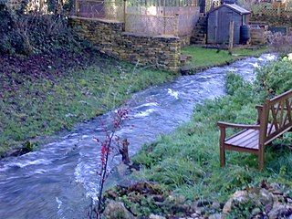
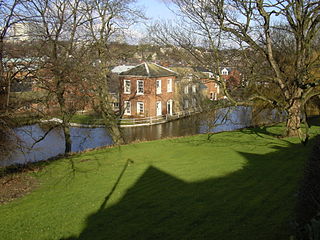
The Avening Valley is located in the South Cotswolds in England, running roughly east from Nailsworth and through the village of Avening.

Bourne Eau River in Lincolnshire, England

Bourne Eau is a short river which rises from an artesian spring in the town of Bourne in Lincolnshire, England, and flows in an easterly direction to join the River Glen at Tongue End. Within the town, it once powered three water mills, one of which is now a heritage centre. At Eastgate, it becomes much wider as it was navigable in the 18th and 19th centuries, and this was the location of the terminal basin. Below the town it is an embanked river, as its normal level is higher than that of the surrounding Fens. Navigation ceased in the 1860s and the river now forms an important part of the drainage system that enables the surrounding fen land to be used for agriculture.

River Frome, Somerset River in Somerset, England

The River Frome is a river in Somerset, England. It rises near Bungalow Farm on Cannwood Lane, south-west of Witham Friary, flows north through Blatchbridge to the town of Frome, and continues in a generally northerly direction passing between the eastern edge of the Mendip Hills and Trowbridge before joining the Bristol Avon at Freshford, below Bradford on Avon.

<span class="mw-page-title-main">River Frome, Stroud</span> River in England

The River Frome, once also known as the Stroudwater, is a small river in Gloucestershire, England. It is to be distinguished from another River Frome in Gloucestershire, the Bristol Frome, and the nearby River Frome, Herefordshire. The river is approximately 25 miles (40 km) long.

<span class="mw-page-title-main">Five Valleys</span>

The Five Valleys are a group of valleys in Gloucestershire, England, which converge on the town of Stroud at the western edge of the Cotswolds. The Five Valleys are notable both for the landscape, which attracts visitors, and their role in industrial development of Britain starting with the wool trade in the 11th Century, and developing through cloth manufacturing in the 18th Century. Despite very poor roads, the use of the rivers and streams in developing links to other centres, via, for example the Thames and Severn Canal, helped the Five Valleys to prosper.

Avening Human settlement in England

Avening is a village and civil parish in the Cotswold district of Gloucestershire, England, about three miles (5 km) north of Tetbury. According to the 2001 census it had a population of 1,094, decreasing to 1,031 at the 2011 census. Nearby is Gatcombe Park, the home of the Princess Royal.

<span class="mw-page-title-main">Blackburn Brook</span> Stream in Sheffield, South Yorkshire, England

The Blackburn Brook is a stream in Sheffield, South Yorkshire, England which flows through the Blackburn Valley along the M1 and Ecclesfield Road and joins the River Don near the Meadowhall shopping centre. Downstream from the A61 road at Chapeltown the Blackburn Brook is defined as a main river by the Environment Agency, which requires new building development to be at least 26 feet (8 m) from the bank side as a flood defence measure and to allow access to the watercourse for maintenance.

Leeds Industrial Museum at Armley Mills

The Leeds Industrial Museum at Armley Mills is a museum of industrial heritage located in Armley, near Leeds, in West Yorkshire, Northern England. The museum includes collections of textile machinery, railway equipment and heavy engineering amongst others.
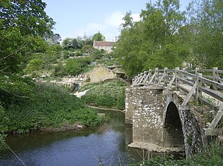
Dudbridge is a suburb on the southern edge of Stroud in Gloucestershire, England.

Haarlem Mill Cotton mill in Derbyshire, England

Haarlem Mill, on the River Ecclesbourne in Wirksworth, Derbyshire, was an early cotton mill. Built by Richard Arkwright, it was the first cotton mill in the world to use a steam engine, though this was used to supplement the supply of water to the mill's water wheel, not to drive the machinery directly.

<span class="mw-page-title-main">Eller Beck</span> River in North Yorkshire, England

The Eller Beck is a small river in North Yorkshire, England, that flows through the town of Skipton and is a tributary of the River Aire. Its channel was heavily modified to supply water to mills in the 18th and 19th centuries, and although all the mills have closed, the water now supplies power to the National Grid, generated by a turbine at High Corn Mill. The beck flows through several underground culverts in Skipton that contribute to the flood risk. To alleviate flooding in Skipton town centre, a scheme involving two flood water storage reservoirs was designed and eventually completed in 2017.

Tonedale Mills Building in Wellington, Somerset

Tonedale Mills, together with the neighbouring Tone Works, is a large textile mill in Wellington, Somerset, and the largest in South West England. Owned for over 200 years by members of the Fox family, it was most famous for the production of 'Taunton serge', and later the khaki cloth and puttees used by the British Army. The mill was established in the middle of the eighteenth century, and thrived during the industrial revolution. At its peak, around 6,500 metres (21,300 ft) of material was produced at the factory each day. The cheap cost of producing fabric in third-world countries contributed to the factory mostly closing during the 1980s, but small-scale production continues on part of the site.

Cherington is a village and civil parish in the Cotswold District of Gloucestershire, England. The population of the civil parish at the 2011 Census was 224.

Egypt Mill Building in Nailsworth, United Kingdom

Egypt Mill is a Grade II* listed building and a former mill located in Nailsworth, a market town within the Stroud district of Gloucestershire, England. The oldest parts of the building date from the 14th century, but the majority dates from the 16th century. Haberdasher George Hudson bought the property in 1656. Two decades later, in 1675, Hudson and his partner Henry Willoughby leased the mill to clothier Richard Webb. The building remained in the hands of the Webb family until 1832, when it was sold to Playne & Smith. It is known as Egypt Mill because Nathan Webb was such a slavedriver that the mill workers nicknamed him Pharaoh, and said they might as well be slaves in Egypt. Peter Playne had previously been the tenant. Late in the 19th century it became a dyeworks and later was used for grinding corn and animal feed and was run by G.H. King & Sons. King restored the name "Egypt Mill", liking the idea of being "King of Egypt". Egypt Mill has been a restaurant, hotel and event venue since the 1980s.

Stanley Mills

The Stanley Mills woolen mill at Ryeford, King's Stanley, Gloucestershire, England was built in the early 19th century. The main building is a Grade I listed building.

Painswick Stream River in England

Painswick Stream is a small river in Gloucestershire, England. It is a tributary of the River Frome, and flows generally southwards, passing around the village of Painswick and through the town of Stroud. It used to join the Frome at its mouth, but was diverted into the then-derelict Stroudwater Navigation as part of a flood relief scheme in the 1950s. Despite its small size, it has been used to power a significant number of mills, many of which were associated with cloth manufacture until the industry was hit by a series of depressions in the 1820s and 1830s. Some found other uses, being used for grinding corn and for the manufacture of walking sticks and umbrella sticks, another prominent local industry. Many were subsequently demolished, but a number survive which have been granted listed building status.

References

  1. 1 2 3 4 Ordnance Survey, 1:2500 map
  2. Historic England. "Gatcombe Park (1000765)". National Heritage List for England . Retrieved 16 October 2021.
  3. Historic England. "Old Mill Buildings at Longfords Mills (1305339)". National Heritage List for England . Retrieved 16 October 2021.
  4. Historic England. "Iron Mills (1172037)". National Heritage List for England . Retrieved 16 October 2021.
  5. Historic England. "Iron Mills (1340449)". National Heritage List for England . Retrieved 16 October 2021.
  6. Historic England. "Chimney at Holcombe Mill (1299071)". National Heritage List for England . Retrieved 17 October 2021.
  7. Historic England. "Workshops to west of Chimney at Holcombe Mill (1186677)". National Heritage List for England . Retrieved 17 October 2021.
  8. Historic England. "Egypt Mill (1120895)". National Heritage List for England . Retrieved 17 October 2021.
  9. Historic England. "L-shaped range of buildings to Dunkirk Mills (1120862)". National Heritage List for England . Retrieved 17 October 2021.
  10. Historic England. "Office building at Merrett's Mill (1120862)". National Heritage List for England . Retrieved 17 October 2021.
  11. Historic England. "North west part of Frogmarsh Mill (1090673)". National Heritage List for England . Retrieved 17 October 2021.
  12. Historic England. "Woodchester Roman villa (1004839)". National Heritage List for England . Retrieved 17 October 2021.
  13. Historic England. "Cotswold Mills House (1090131)". National Heritage List for England . Retrieved 18 October 2021.
  14. Historic England. "Lightpill Mill (1340940)". National Heritage List for England . Retrieved 18 October 2021.
  15. Historic England. "Flour Mill (1222882)". National Heritage List for England . Retrieved 18 October 2021.
  16. Tann 2012, pp. 31–32.
  17. Tann 2012, p. 86.
  18. Tann 2012, p. 96.
  19. Tann 2012, pp. 165–166.
  20. Tann 2012, p. 97.
  21. Tann 2012, p. 112.
  22. Tann 2012, pp. 105–106.
  23. Tann 2012, p. 245.
  24. Tann 2012, pp. 244–245.
  25. "Glossary (see Biological quality element; Chemical status; and Ecological status)". Catchment Data Explorer. Environment Agency. Retrieved 15 May 2017.
  26. "Nailsworth Stream - source to conf R Frome". Catchment Data Explorer. Environment Agency. Retrieved 16 October 2021.

Commons-logo.svg Media related to Nailsworth Stream at Wikimedia Commons