Related Research Articles

The A38, parts of which are known as Devon Expressway, Bristol Road and Gloucester Road, is a major A-class trunk road in England.

The M5 is a motorway in England linking the Midlands with the South West. It runs from junction 8 of the M6 at West Bromwich near Birmingham to Exeter in Devon. Heading south-west, the M5 runs east of West Bromwich and west of Birmingham through Sandwell Valley. It continues past Bromsgrove, Droitwich Spa, Worcester, Tewkesbury, Cheltenham, Gloucester, Bristol, Portishead, Clevedon, Weston-super-Mare, Bridgwater, Taunton, Tiverton, Cullompton terminating at junction 31 for Exeter.

Stroud District is a local government district in Gloucestershire, England. The district is named after its largest town of Stroud. The council is based at Ebley Mill in Cainscross. The district also includes the towns of Berkeley, Dursley, Nailsworth, Stonehouse and Wotton-under-Edge, along with numerous villages and surrounding rural areas. Over half of the district lies within the Cotswolds Area of Outstanding Natural Beauty.

The M32 is a 4.4-mile-long (7.1 km) motorway in South Gloucestershire and Bristol, England. It provides a link from the M4, a major motorway linking London and South Wales, to Bristol city centre and is maintained by National Highways, the national roads body.
The A361 is an A class road in southern England, which at 195 miles (314 km) is the longest three-digit A road in the UK.

The A38(M), commonly known as the Aston Expressway, is a motorway in Birmingham, England. It is 2 miles (3.2 km) long and was opened on 24 May 1972. It connects the M6 motorway to Aston and Central Birmingham and forms part of the much longer A38 route.

A dual carriageway (BrE) or a divided highway (AmE) is a class of highway with carriageways for traffic travelling in opposite directions separated by a central reservation (BrE) or median (AmE). Roads with two or more carriageways which are designed to higher standards with controlled access are generally classed as motorways, freeways, etc., rather than dual carriageways.

The A419 road is a primary route between Chiseldon near Swindon at junction 15 of the M4 with the A346 road, and Whitminster in Gloucestershire, England near the M5 motorway. The A419 is managed and maintained by a private company, Road Management Group, on behalf of the UK Department for Transport.

The A417 is a main road in England, running from Streatley, Berkshire to Hope under Dinmore, Herefordshire. It is best known for its section between Cirencester and Gloucester where it has primary status and forms part of the link between the major settlements of Swindon and Gloucester.
Stonehouse is a town in the Stroud District of Gloucestershire in southwestern England.

The River Frome, once also known as the Stroudwater, is a small river in Gloucestershire, England. It is to be distinguished from another River Frome in Gloucestershire, the Bristol Frome, and the nearby River Frome, Herefordshire. The river is approximately 25 miles (40 km) long.

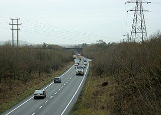
Hardwicke is a large village on the A38 road 7 km south of the city of Gloucester, Gloucestershire, England. Despite its proximity to Gloucester, the village comes under Stroud Council. The population of the village taken at the United Kingdom Census 2011 was 3,901.

Quedgeley is a town and civil parish in the city of Gloucester district in Gloucestershire, England. A thin strip of land between the Severn and the Gloucester Ship Canal occupies the west, and the south-eastern part of the town is Kingsway Village, directly to the north of which is Tuffley.

The Almondsbury Interchange in South Gloucestershire, is one of the United Kingdom's largest motorway stack interchanges. The interchange is one of only three four-level stacks in the UK, spanning a range of 1 km by 1 km. It is the interchange for the M5 at junction 15 and M4 at junction 20, and is situated at the northern fringes of Bristol close to the village of Almondsbury, the Aztec West industrial estate, and Bradley Stoke. When it opened in 1966, it was the most complex junction on the British motorway network, a free-flowing interchange on four levels. Since then traffic volumes have increased. At busy periods, the Interchange becomes more difficult to negotiate safely. In an attempt to ease congestion, the Interchange has become part of a smart motorway.

Eastington is a village and civil parish in Gloucestershire, England. It lies 4 miles west of Stroud and 9 miles south of Gloucester at the entrance to the Stroud Valley. It is west of the town of Stonehouse and south of Junction 13 of the M5 motorway and the A38 and A419 roads. Since the M5 and its access roads were opened, the main road no longer runs through the village.

A single carriageway is a road with one, two or more lanes arranged within a one carriageway with no central reservation/median strip to separate opposing flows of traffic. A single-track road is a type of single carriageway with a single lane with passing places for traffic in both directions. An undivided highway is the term used for motorways with two or more lanes with no central reservation/median strip. Road traffic safety is generally worse for high-speed single carriageways than for dual carriageways due to the lack of separation between traffic moving in opposing directions.
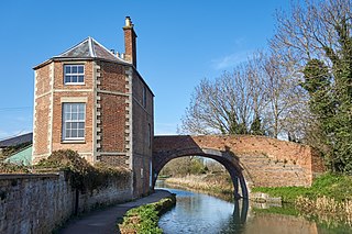
The Stroudwater Navigation is a canal in Gloucestershire, England which linked Stroud to the River Severn. It was authorised in 1776, although part had already been built, as the proprietors believed that an Act of Parliament obtained in 1730 gave them the necessary powers. Opened in 1779, it was a commercial success, its main cargo being coal. It was 8 miles (13 km) in length and had a rise of 102 ft 5 in (31.22 m) through 12 locks. Following the opening of the Thames and Severn Canal in 1789, it formed part of a through route from Bristol to London, although much of its trade vanished when the Kennet and Avon Canal provided a more direct route in 1810. Despite competition from the railways, the canal continued to pay dividends to shareholders until 1922, and was not finally abandoned until 1954.

Dudbridge railway station served the Stroud suburb of Dudbridge and the village of Selsley, little more than 1 mile (1.6 km) from Stroud, in Gloucestershire, England. The station was on the 5+3⁄4 miles (9.3 km) long Stonehouse and Nailsworth Railway, later part of the Midland Railway.
The Cotswold Canals Trust is a British registered charity that aims to protect and restore the Stroudwater Navigation and the Thames and Severn Canal. Formed in 1972, the organisation has a goal to restore navigability on the two waterways between Saul Junction and the River Thames. Since then, it has overseen restoration of the waterways, with many bridges, locks, and cuttings being rebuilt and reinstated.

Marshall Road is an east–west road in the northern suburbs of Perth, Western Australia. It is continuous with Beach Road.
References
- ↑ "B4008 map" (Map). Google Maps . Retrieved 7 August 2016.
- ↑ "B4008 Bristol Road Hardwicke - Proposed 30mph". Gloucestershire County Council. Retrieved 7 August 2016.
- ↑ "B4008". SABRE. Retrieved 25 October 2019.