Gloucester and Sharpness Canal

Last updated

A map of the canal from 1933 Gloucester and Sharpness Canalmap.jpg
A map of the canal from 1933
Gloucester and Sharpness Canal
BSicon uexCONTgq.svg
BSicon ugLockr.svg
BSicon uSTR+l.svg
BSicon uexFABZq+lr.svg
BSicon uSTRq.svg
BSicon uCONTfq.svg
River Severn (Gloucester)
BSicon uLIFT.svg
BSicon uLock3.svg
Gloucester Dock Lock (with lift bridge over)
BSicon uDOCKae.svg
Gloucester Docks
BSicon uFABZgl+l.svg
BSicon uMARINAl.svg
Victoria Dock
BSicon uDRYr.svg
BSicon uFABZgr+r.svg
Dry Dock
BSicon uFABZgl+l.svg
BSicon uDOCKr.svg
Barge Arm
BSicon uLIFT.svg
Llanthony Bridge
BSicon RACONTg.svg
BSicon uWHRF.svg
Llanthony Wharf, Bakers Quay
BSicon RAe.svg
BSicon RA.svg
BSicon RAq.svg
BSicon uAKRZuba.svg
BSicon RAq.svg
BSicon RACONTfq.svg
High Orchard Bridge, A430 Inner Ring Road
BSicon RA.svg
BSicon uDOCKl.svg
BSicon uFABZgr+r.svg
Monk Meadow Dock
BSicon RA.svg
BSicon uSWING.svg
Hempstead Bridge
BSicon RA.svg
BSicon ueABZgl.svg
BSicon gSTR+r.svg
Old section of Two Mile Bend
BSicon RAl.svg
BSicon DRAq.svg
BSicon uAKRZusw.svg
BSicon DRAq.svg
BSicon gSTR.svg
BSicon RA+r.svg
Netheridge Bridge, A430 South-Western Bypass
BSicon ueABZg+l.svg
BSicon gSTRr.svg
BSicon RACONTf.svg
Old section of Two Mile Bend
BSicon uSWING.svg
Simms Bridge
BSicon uKRZuysw.svg
Rea Bridge
BSicon uKRZuysw.svg
Sellars Bridge
BSicon uKRZuysw.svg
Parkend Bridge
BSicon WCONTgq.svg
BSicon WASSER+r.svg
BSicon WASSERq.svg
BSicon uWBRUCKE2.svg
BSicon uxWEIRfl.svg
BSicon uexSTR+l.svg
BSicon uexCONTfq.svg
River Frome
BSicon exWWSELlf.svg
BSicon uWEIRl.svg
BSicon uxWEIRg.svg
Whitminster Weir feeder and overflow
BSicon uSTRbl.svg
BSicon uextSTRa.svg
Wycliffe College Boat Club
BSicon uSWING.svg
BSicon uextSTR.svg
Saul Junction Foot Bridge
BSicon gCONTgq.svg
BSicon uexLockr.svg
BSicon uFKRZ.svg
BSicon uFABZq+lr.svg
BSicon uextSTR.svg
BSicon uCONTfq.svg
Stroudwater Navigation (Saul Junction)
BSicon uSTR.svg
BSicon uMARINAg.svg
Saul Junction Marina
BSicon uFABZgl+l.svg
BSicon uDRYl.svg
Dry Dock
BSicon uKRZuysw.svg
Sandfield Bridge
BSicon HUBq.svg
BSicon lELC.svg
BSicon HUBq.svg
BSicon HUBq.svg
BSicon uSTR.svg
BSicon HUBq.svg
BSicon HUBq.svg
BSicon lELC.svg
Power lines to Lydney (clearance 105 feet (32 m))
BSicon uKRZuysw.svg
Fretherne Bridge
BSicon uSWING.svg
Splatt Bridge
BSicon uSTR.svg
BSicon ugDOCKf.svg
Former canal basin at Cambridge
BSicon ueFABZgl+l.svg
BSicon uexLockr.svg
BSicon uexSTRr.svg
BSicon WSHI1rq.svg
Cambridge Arm, River Cam
BSicon uSWING.svg
Cambridge Arms Bridge
BSicon lNAT.svg
BSicon uSTR.svg
Slimbridge Wetland Reserve
BSicon RYl.svg
BSicon uKRZuysw.svg
Patch Bridge
BSicon uSTRbr.svg
BSicon uexnSTRl.svg
BSicon uexnSTR+r.svg
Purton Water Treatment Works
BSicon uSTR.svg
BSicon uexnSTRl.svg
BSicon uexnCONTfq.svg
Bristol Water pipeline to Pucklechurch
BSicon uSWING.svg
Purton Upper Bridge
BSicon uSWING.svg
Purton Lower Bridge
BSicon uSTR+FEATURE@r.svg
Purton Hulks
BSicon uxmKRZusw.svg
Severn Railway Bridge remains
BSicon uWHRFq.svg
BSicon uFABZgr+r.svg
Sharpness Barge Arm (from old entrance)
BSicon uSWING.svg
High Level Bridge
BSicon uKRZuysw.svg
Low Level Bridge
BSicon uDOCKae.svg
Sharpness New Dock
BSicon uLock5.svg
Sharpness Lock
BSicon uHST.svg
Tidal Basin
BSicon uFGATEu.svg
Tidal Basin Gates
BSicon uCONTgq.svg
BSicon uFABZqlr.svg
BSicon uVEEfq.svg
Severn Estuary (Sharpness)

The Gloucester and Sharpness Canal (also known as the Gloucester and Berkeley Canal) is a ship canal in the west of England, between Gloucester and Sharpness, completed in 1827. For much of its length the canal runs close to the tidal River Severn, but it cuts off a significant loop in the river, at a once-dangerous bend near Arlingham. It was once the broadest and deepest canal in the world. The canal is 26.5 km (16.5 miles) [1] long.

Contents

Canal planning and construction

Founder's share of the Glocester and Berkeley Canal Company, issued 29 September 1794, printed on vellum. The proprietors of this canal were authorised to raise the sum of PS140,000 to be divided into shares of PS100 each. If the former sum be insufficient, they could raise a further sum of PS60,000. Glocester and Berkeley Canal Company 1794.jpg
Founder's share of the Glocester and Berkeley Canal Company, issued 29 September 1794, printed on vellum. The proprietors of this canal were authorised to raise the sum of £140,000 to be divided into shares of £100 each. If the former sum be insufficient, they could raise a further sum of £60,000.

Conceived in the canal mania period of the late 18th century, the Gloucester and Berkeley Ship Canal scheme (as it was originally named) was started by architect and civil engineer Robert Mylne. In 1793 an Act of Parliament (33 Geo. 3. c. 97) was obtained authorising the raising of a total of £200,000. [3] The project rapidly encountered financial difficulties, to such an extent that Mylne left the project in 1798.

By mid-1799 costs had reached £112,000 but only 5+12 miles (9 km) of the canal had been completed. [4] Mylne's role was taken over by James Dadford, who had originally been engaged as resident engineer on the project in 1795. [5] Lack of funds resulted in the company ceasing to employ Dadford in 1800. [4]

Decade of capital raising

Between 1800 and 1810 various unfruitful attempts were made to raise money to allow further building. [4] Money from tolls and rents allowed for some improvements to be made to the basin at Gloucester in 1813. [6]

Eventual completion

Following the Poor Employment Act 1817, it was possible for the company to borrow money from the Exchequer Bill Loan Commission. This, along with further share issues, provided enough money to bring the scheme to completion. [7] After these significant delays, the canal opened in April 1827. In the course of its construction the canal had cost £440,000 (equivalent to £41,000,000in 2021). [8] As opened, the canal was 86+12 feet (26.4 m) wide, 18 feet (5.5 m) deep and could take craft of up to 600 long tons (610 tonnes; 670 short tons). The longer of the two locks onto the canal proper was 115 feet (35 m) long. [8]

Eventual dividends

By the middle of the 19th century it proved possible to pay a small dividend, the debt to the Exchequer Bill Loan Commission having been repaid with the help of a loan of £60,000 from the Pelican Life Assurance Company. [8] In 1871 the last of the debts incurred in the course of funding the canal, including the Pelican loan, were paid off. [9] Where the Severn Railway Bridge (completed in 1879) passed over the canal, a swing section was constructed [10] to avoid restricting headroom.

Purton hulks

In 1909, following a collapse in the bank of the river, the canal company's chief engineer A. J. Cullis called for old vessels to be run aground along the bank of the Severn, near Purton, to create a makeshift tidal erosion barrier to reinforce the narrow strip of land between the river and canal. [11] Barges, trows and schooners were "hulked" at high tide, and have since filled with silt. More boats have been added, including the schooner Katherine Ellen which was impounded in 1921 for running guns to the IRA, the Kennet barge Harriett, and ferrocement barges built in World War II. [12]

In 1999, Paul Barnett started a privately funded research project to record the 81 vessels at the site, recognised as the largest ships' graveyard in mainland Britain. [13] In 2010 British Waterways took control of the site in an attempt to protect it. [14]

Bridge-houses

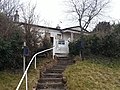
Eight of the bridges have Neo-classical bridge-men's houses in the near vicinity. These were built in the early 19th century when the volume of traffic on the canal made it important that all the bridges could open at night so that vessels could meet the tides at Sharpness. At that time, the other bridge-men lived in existing houses that were close enough to their bridges.

The classical-style bridge-men's houses were originally symmetrical in plan with gables on each elevation. Each had a living room, one bedroom, a scullery at the back and a porch with Doric columns at the front. In later years, the houses have been extended to provide more accommodation and modern facilities. Today, the houses are in private ownership, and most of them are Grade II listed.

Modern times

In 1905 traffic exceeded one million tons for the first time. [15] Oil was added to the list of cargoes carried by the canal, with bulk oil carriers taking fuel to storage tanks sited to the south of Gloucester. [16] In 1937 the canal was navigated by the submarines HMS H33 and HMS H49. [17] The canal was nationalized in 1948. [18] At the same time the Sharpness Dock Police which had policed the dock since 1874 were absorbed into the British Transport Police. [19]

In 1955 the Board of Survey of Canals and Inland Waterways released a report that, among other things, described the Gloucester and Sharpness Canal as carrying substantial traffic and offering scope for commercial development. [20]

The River Cam, which is subject to accretion due to industrial and agricultural runoff, is an important feeder for the Gloucester and Sharpness Canal. [21] It was formerly navigable as the Cambridge Arm [22] with one entrance lock leading to a basin and wharf at Cambridge, the limit of navigation due to mill weirs and low bridges on the Bristol to Gloucester road. The lock was missing and the basin abandoned by 1901. [23] Most of the straightened channel has survived as flood defence improvements and is potentially still navigable, but the entrance is now blocked by a very low bridge at the site of the former lock. [24]

By the mid-1980s commercial traffic had largely come to a halt, the canal being given over to pleasure cruisers with the exception of a few passages by grain barges. [16] The oil trade ceased in 1985 with the closure of the petroleum depot at Quedgeley. [10] In order to allow the A430 Gloucester southwestern bypass to be built the canal had to be diverted. This new cut eliminated a major problem which had plagued commercial traffic since opening: the sharp double bend in the canal. The new section of channel was opened on 6 May 2006. [25] In January 2009 a project began to replace the Patch Bridge swing bridge with a motor-powered design instead of the former hand-cranked system. [26]

Today, the canal can be used by boats up to 64 m (210 ft) in length, 9.6 m (31 ft) in beam and 32 m (105 ft) in height. The maximum draft is 3.5 m (11 ft). [1]

The canal links directly to the Stroudwater Navigation at Saul Junction, the only such flat crossing between two different canal companies anywhere in the world. [27]

See also

Related Research Articles

<span class="mw-page-title-main">Thames and Severn Canal</span> Canal in Gloucestershire in the south-west of England

The Thames and Severn Canal is a canal in Gloucestershire in the south-west of England, which was completed in 1789. It was conceived as part of a cargo route from Bristol and the Midlands to London, linking England's two largest rivers for better trade. The route climbs the steep Cotswold escarpment through the Golden Valley, tunnels underneath the summit of the Cotswold Edge, and emerges near the source of the Thames.

<span class="mw-page-title-main">Herefordshire and Gloucestershire Canal</span>

The Herefordshire and Gloucestershire Canal is a canal in the west of England, which ran from Hereford to Gloucester, where it linked to the River Severn. It was opened in two phases in 1798 and 1845, and closed in 1881, when the southern section was used for the course of the Ledbury and Gloucester Railway. It is the subject of an active restoration scheme.

<span class="mw-page-title-main">Canals of the United Kingdom</span> Network of inland waterways

The canals of the United Kingdom are a major part of the network of inland waterways in the United Kingdom. They have a varied history, from use for irrigation and transport, through becoming the focus of the Industrial Revolution, to today's role of recreational boating. Despite a period of abandonment, today the canal system in the United Kingdom is again increasing in use, with abandoned and derelict canals being reopened, and the construction of some new routes. Canals in England and Wales are maintained by navigation authorities. The biggest navigation authorities are the Canal & River Trust and the Environment Agency, but other canals are managed by companies, local authorities or charitable trusts.

<span class="mw-page-title-main">Sharpness</span> Human settlement in England

Sharpness is an English port in Gloucestershire, one of the most inland in Britain, and eighth largest in the South West England region. It is on the River Severn at grid reference SO669027, at a point where the tidal range, though less than at Avonmouth downstream, is still large.

<span class="mw-page-title-main">Severn Railway Bridge</span> Former bridge in United Kingdom

The Severn Railway Bridge was a bridge carrying the railway across the River Severn between Sharpness and Lydney in Gloucestershire, England. It was built in the 1870s by the Severn Bridge Railway Company, primarily to carry coal from the Forest of Dean to the docks at Sharpness; it was the furthest-downstream bridge over the Severn until the opening of the Severn road bridge in 1966. When the company got into financial difficulties in 1893, it was taken over jointly by the Great Western Railway and the Midland Railway companies. The bridge continued to be used for freight and passenger services until 1960, and saw temporary extra traffic on the occasions that the Severn Tunnel was closed for engineering work.

<span class="mw-page-title-main">Droitwich Canal</span>

The Droitwich Canal is a synthesis of two canals in Worcestershire, England; the Droitwich Barge Canal and the Droitwich Junction Canal. The Barge Canal is a broad canal which opened in 1771 linking Droitwich Spa to the River Severn at Hawford Bottom Lock, Claines. The Droitwich Junction Canal is a narrow canal, opened in 1854, which linked Droitwich to the Worcester and Birmingham Canal. Both were built to carry salt, and were abandoned in 1939. They have been the subject of a restoration plan since 1973, and the Barge Canal was officially reopened in 2010, while the Junction Canal reopened in July 2011. Following the opening of the canal, ownership transferred to the newly created Canal and River Trust

<span class="mw-page-title-main">Leominster Canal</span> Canal in England, now defunct

The Leominster Canal was an English canal which ran for just over 18 miles from Mamble to Leominster through 16 locks and a number of tunnels, some of which suffered engineering problems even before the canal opened. Originally, the canal was part of a much more ambitious plan to run 46 miles from Stourport to Kington.

<span class="mw-page-title-main">River Frome, Stroud</span> River in England

The River Frome, once also known as the Stroudwater, is a small river in Gloucestershire, England. It is to be distinguished from another River Frome in Gloucestershire, the Bristol Frome, and the nearby River Frome, Herefordshire. The river is approximately 25 miles (40 km) long.

<span class="mw-page-title-main">River Cam, Gloucestershire</span> River in Gloucestershire, England

The River Cam is a small river in Gloucestershire, England. It flows for 12 miles (20 km) north-westwards from the Cotswold Edge, across the Vale of Berkeley, into the Gloucester and Sharpness Canal.

The Bristol and Gloucester Railway was a railway company opened in 1844 to run services between Bristol and Gloucester. It was built on the 7 ftBrunel gauge, but it was acquired in 1845 by the 4 ft 8+12 instandard gauge Midland Railway, which also acquired the Birmingham and Gloucester Railway at the same time.

<span class="mw-page-title-main">Arlingham</span> Human settlement in England

Arlingham is a village and civil parish in the Stroud District of Gloucestershire, England. The 2021 Census recorded a parish population of 533. The parish contains the hamlets of Milton End, Overton and Priding. The next parish to the east is Fretherne with Saul.

<span class="mw-page-title-main">Stroudwater Navigation</span> Canal in Gloucestershire, England

The Stroudwater Navigation is a canal in Gloucestershire, England which linked Stroud to the River Severn. It was authorised in 1776, although part had already been built, as the proprietors believed that an Act of Parliament obtained in 1730 gave them the necessary powers. Opened in 1779, it was a commercial success, its main cargo being coal. It was 8 miles (13 km) in length and had a rise of 102 ft 5 in (31.22 m) through 12 locks. Following the opening of the Thames and Severn Canal in 1789, it formed part of a through route from Bristol to London, although much of its trade vanished when the Kennet and Avon Canal provided a more direct route in 1810. Despite competition from the railways, the canal continued to pay dividends to shareholders until 1922, and was not finally abandoned until 1954.

Josiah Clowes (1735–1794) was a noted English civil engineer and canal builder. His early years were spent running a canal carrying company with Hugh Henshall, and although he worked on some canal projects before 1783, that year marked his switch to being an engineer. His first major project included the Sapperton Tunnel on the Thames and Severn Canal, which despite huge engineering difficulties, gained him a reputation which enabled him to become the first great tunnelling engineer, responsible for three of the four longest canal tunnels built.

<span class="mw-page-title-main">Purton, Berkeley</span>

Purton is a village on the east bank of the River Severn, 3 miles north of Berkeley, in Gloucestershire, England. The village is in the civil parish of Hinton. It lies opposite the hamlet of Purton on the west bank of the river.

<span class="mw-page-title-main">Severn Bridge Railway</span> United Kingdom legislation

The Severn Bridge Railway was a railway company which constructed a railway from Lydney to Sharpness in Gloucestershire, England. It was intended chiefly to give access for minerals in the Forest of Dean to Sharpness Docks, and the company built a long bridge, 1,387 yards (1,268 m) in length, over the River Severn. The line opened in 1879.

<span class="mw-page-title-main">Purton Hulks</span> Boats to reinforce the banks of the River Severn

The Purton Hulks or Purton Ships' Graveyard is a number of abandoned boats and ships, deliberately beached beside the River Severn near Purton in Gloucestershire, England, to reinforce the river banks. Most were beached in the 1950s and are now in a state of considerable decay. The site forms the largest ship graveyard in mainland Britain.

The Cotswold Canals Trust is a British registered charity that aims to protect and restore the Stroudwater Navigation and the Thames and Severn Canal. Formed in 1972, the organisation has a goal to restore navigability on the two waterways between Saul Junction and the River Thames. Since then, it has overseen restoration of the waterways, with many bridges, locks, and cuttings being rebuilt and reinstated.

<span class="mw-page-title-main">Stroudwater barge</span>

A Stroudwater barge was a type of barge developed for use on the Stroudwater Navigation, a canal in Gloucestershire.

<span class="mw-page-title-main">Cassington Canal</span> Canal in Oxfordshire

The Cassington Canal was an early 19th-century canal near Eynsham, Oxfordshire. The canal was built by the 4th Duke of Marlborough to provide a link between the River Thames and Cassington Mill; it later provided alternative wharfage to that at Eynsham. The 0.75-mile (1.21 km) canal was in operation for less than 70 years, its use declining with the advent of rail transport.

References

  1. 1 2 "Inland Waterways Association: Gloucester and Sharpness Canal" . Retrieved 24 April 2013.
  2. "The History of Cheltenham and its Environs", Cheltenham, Printed and published by H. Ruff, 1803. p. 318
  3. Hadfield (1969), p.342
  4. 1 2 3 Hadfield (1969), p.344
  5. Hadfield (1969), p.343
  6. Hadfield (1969), p.345
  7. Hadfield (1969), p.346
  8. 1 2 3 Hadfield (1969), p.348
  9. Hadfield (1969), p.351
  10. 1 2 Paget-Tomlinson (2006), pp.124–125
  11. "The Purton Hulks". morturn.com – Legacy from the past. Retrieved 19 October 2008.
  12. "Purton Hulks – maritime history sunk by neglect". telegraph.co.uk. London. 18 October 2008. Archived from the original on 20 October 2008. Retrieved 19 October 2008.
  13. "The Friends of Purton".
  14. "Purton Hulks taken over by British Waterways". BBC News. 22 September 2010. Retrieved 6 October 2010.
  15. Hadfield (1969), p.352
  16. 1 2 Green (1999), p.27
  17. Tall and Kemp (1996), p.64
  18. "Waterways Virtual Archive Catalogue". Archived from the original on 28 September 2007. Retrieved 28 August 2007.
  19. "Sharpness Dock Police (1874–1948)". Archived from the original on 14 June 2004. Retrieved 28 August 2007.
  20. "Uneconomic Canals Use Of 771 Miles "Not Justified"". The Times. 21 April 1955. p. 7.
  21. "54098 – Cam at Cambridge". National River Flow Archive. Retrieved 18 February 2024.
  22. "View map: Ordnance Survey, Gloucestershire XLVIII.NE (includes: Cam; Coaley; Eastington; Frampton on Severn... - Ordnance Survey Six-inch England and Wales, 1842-1952". maps.nls.uk. Retrieved 15 March 2023.
  23. "View map: Ordnance Survey, Gloucestershire XLVIII.3 (Coaley; Eastington; Frampton on Severn; Frocester; Sli... - Ordnance Survey 25 inch England and Wales, 1841-1952". maps.nls.uk. Retrieved 15 March 2023.
  24. "Song of the Paddle Forum-Gloucestershire River Cam". Song of the Paddle Forum. Retrieved 15 March 2023.
  25. "Canal's new channel section opens". BBC News. 6 May 2006. Retrieved 25 August 2007.
  26. Clare, Rachel (6 January 2009). "Wardens at bird sanctuary travel by boat". stroud news and journal. Retrieved 7 January 2009.
  27. "Saul Junction - Stroudwater History". stroudwaterhistory.org.uk. Retrieved 15 March 2023.

Bibliography

  • Colin Green (1999). Severn Traders. Black Dwarf Publications. ISBN   0-9533028-2-2.
  • Charles Hadfield (1969). The Canals of South and South East England. David and Charles. ISBN   0-7153-4693-8.
  • Edward Paget-Tomlinson (2006). The Illustrated History of Canal & River Navigations (3rd ed.). Landmark Publishing Ltd. ISBN   1-84306-207-0.
  • J.J. Tall; Paul Kemp (1996). HM Submarines in Camera An Illustrated History of British Submarines. Sutton Publishing. ISBN   0-7509-0875-0.

51°44′N2°29′W / 51.733°N 2.483°W / 51.733; -2.483