Listed by name
| Tunnel | Canal | Length | Designer | Coordinates | Notes | Image |
|---|---|---|---|---|---|---|
| Ashford Tunnel | Monmouthshire and Brecon Canal | 375 yards (343 m) [1] | Thomas Dadford | 51°53.195′N3°16.525′W / 51.886583°N 3.275417°W | Brecknockshire/Powys Tunnel narrows considerably between northern and southern portals due to repairs to its fabric but is nevertheless navigable by a narrowboat with relative ease. |  |
| Ashperton Tunnel | Herefordshire and Gloucestershire Canal | 400 yards (370 m) | ||||
| Aylestone Tunnel | Herefordshire and Gloucestershire Canal | 440 yards (400 m) | ||||
| Berwick Tunnel | Shrewsbury Canal | 970 yards (890 m) | Josiah Clowes | 52°42′4.97″N2°41′22.22″W / 52.7013806°N 2.6895056°W | Claimed to be the first canal tunnel with a towpath throughout. | 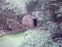 |
| Blisworth Tunnel | Grand Union Canal | 3,056 yards (2,794 m) [2] | Northamptonshire |  | ||
| Branwood Tunnel | Stratford-upon-Avon Canal | 352 yards (322 m) [3] |  | |||
| Braunston Tunnel | Grand Union Canal | 2,042 yards (1,867 m) [2] | Jessop & Barnes | 52°16.976′N1°10.041′W / 52.282933°N 1.167350°W | Northamptonshire |  |
| Bruce Tunnel | Kennet and Avon Canal | 502 yards (459 m) [4] |  | |||
| Butterley Tunnel | Cromford Canal | 3,063 yards (2,801 m) [5] | 53°3.3841′N1°22.3994′W / 53.0564017°N 1.3733233°W | Derbyshire |  | |
| Chirk Tunnel | Llangollen Canal | 459 yards (420 m) [6] | 52°55′46.91″N3°3′46.77″W / 52.9296972°N 3.0629917°W | Near Chirk |  | |
| Cookley Tunnel | Staffordshire & Worcestershire Canal | 65 yards (59 m) [7] |  | |||
| Drakeholes Tunnel | Chesterfield Canal | 154 yards (141 m) [8] |  | |||
| Dudley Tunnel | Birmingham Canal Navigations | 3,172 yards (2,900 m) [9] | 52°31′18″N2°04′42″W / 52.52173°N 2.07840°W | Part of Dudley Canal Line No 1 | 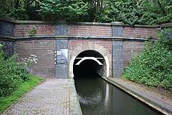 | |
| Dunsley Tunnel | Staffordshire & Worcestershire Canal | 25 yards (23 m) [10] | 52°27′25″N2°12′34″W / 52.4568191°N 2.2093904°W |  | ||
| Edgbaston Tunnel | Worcester and Birmingham Canal | 105 yards (96 m) | ||||
| Foulridge Tunnel | Leeds and Liverpool Canal | 1,630 yards (1,490 m) [11] | Robert Whitworth/Samuel Fletcher | 53°52′28″N2°10′56″W / 53.8745°N 2.1821°W | Also known as the Mile Tunnel [12] |  |
| Gosty Hill Tunnel | Birmingham Canal Navigations | 557 yards (509 m) [13] | Part of Dudley Canal Line No 2 |  | ||
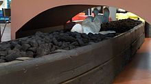
| Greywell Tunnel | Basingstoke Canal | 1,200 yards (1,100 m) [14] | Closed to traffic following cave-in. Now home to Europe's largest bat colony. |  | ||
| Hardham Tunnel | Arun Navigation | 375 yards (343 m) | 50°56′56″N0°31′23″W / 50.94889°N 0.52306°W | Closed since 1888; blocked in 1895 by LBSCR under Mid Sussex Line and Midhurst-Pulborough Line. | 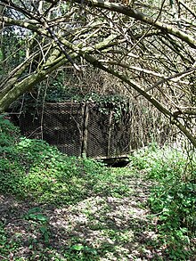 | |
| Harecastle Tunnel | Trent & Mersey Canal | 2,926 yards (2,676 m) [15] | James Brindley/Thomas Telford | 53°4′27″N2°14′11″W / 53.07417°N 2.23639°W | Staffordshire. Comprises parallel "Brindley" and "Telford" tunnels. (The length stated is for the Telford tunnel.) |  |
| Hincaster Tunnel | Lancaster Canal | 378 yards (346 m) | Thomas Fletcher | 54°15′33″N2°45′18″W / 54.25917°N 2.75500°W | Opened in 1819. Commercial traffic on the Lancaster Canal ceased north of Lancaster in 1944 and this part of the canal was officially closed following the Transport Act, 1955. | |
| Lapal Tunnel | Birmingham Canal Navigations | 3,795 yards (3,470 m) [16] | 52°26′42″N2°00′06″W / 52.4450°N 2.0017°W | Part of Dudley Canal Line No 2 (disused—closed 1907) |  | |
| Lord Ward's Tunnel | Birmingham Canal Navigations | 196 yards (179 m) [17] | In the Dudley Tunnel complex | |||
| Netherton Tunnel | Birmingham Canal Navigations | 3,027 yards (2,768 m) [9] | 52°30′25″N2°03′25″W / 52.50697°N 2.05708°W |  | ||
| Newbold Tunnel | Oxford Canal | 250 yards (230 m) [18] |  | |||
| Newnham Tunnel | Leominster Canal | 100 yards (91 m) | 52°19′37″N2°31′20″W / 52.32685°N 2.52223°W | Worcestershire | ||
| Norwood Tunnel | Chesterfield Canal | 2,884 yards (2,637 m) [19] | James Brindley | 53°20′06″N1°16′11″W / 53.33501°N 1.26971°W | Derbyshire to South Yorkshire. Closed with plans for partial restoration of eastern end. |  |
| Oxenhall Tunnel | Herefordshire and Gloucestershire Canal | 2,192 yards (2,004 m) | ||||
| Pensax Tunnel | Leominster Canal | 3,850 yards (3,520 m) | 52°19′22″N2°23′27″W / 52.32265°N 2.39083°W | Worcestershire Abandoned during construction. | ||
| Putnall Tunnel | Leominster Canal | 330 yards (300 m) | 52°17′38″N2°43′58″W / 52.29398°N 2.73266°W | Herefordshire | ||
| Sapperton Canal Tunnel | Thames and Severn Canal | 3,817 yards (3,490 m) [20] | Josiah Clowes | 51°42′45″N2°03′42″W / 51.7126°N 2.0618°W | Gloucestershire |  |
| Scout Tunnel | Huddersfield Narrow Canal | 220 yards (200 m) [21] | Unlined, rock tunnel |  | ||
| Shortwood Tunnel | Worcester and Birmingham Canal | 613 yards (561 m) | ||||
| Southnett Tunnel | Leominster Canal | 1,250 yards (1,140 m) | 52°19′43″N2°28′37″W / 52.32874°N 2.47691°W | Herefordshire | ||
| Standedge Tunnels | Huddersfield Narrow Canal | 5,698 yards (5,210 m) [21] | 53°35′29″N1°57′36″W / 53.591283°N 1.95996°W | West Yorkshire to Greater Manchester |  | |
| Strood Tunnel | Thames and Medway Canal | 3,946 yards (3,608 m) | Ralph Walker | 51°24′54″N0°28′52″E / 51.4149°N 0.4812°E | Kent | |
| Tardebigge Tunnel | Worcester and Birmingham Canal | 580 yards (530 m) | ||||
| Wast Hill Tunnel | Worcester and Birmingham Canal | 2,726 yards (2,493 m) [22] | 52°23′25″N1°56′24″W / 52.3902°N 1.9400°W | West Midlands (county) to Worcestershire |  |