The Wilts & Berks Canal is a canal in the historic counties of Wiltshire and Berkshire, England, linking the Kennet and Avon Canal at Semington near Melksham, to the River Thames at Abingdon. The North Wilts Canal merged with it to become a branch to the Thames and Severn Canal at Latton near Cricklade. Among professional trades boatmen, the canal was nicknamed the Ippey Cut, possibly short for Chippenham.

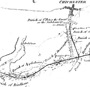
The Portsmouth and Arundel Canal was a canal in the south of England that ran between Portsmouth and Ford in the Arundel district, it was built in 1823 but was never a financial success and was abandoned in 1855; the company was wound up in 1888. The canal was part of a larger scheme for the construction of a secure inland canal route from London to Portsmouth, which allowed craft to move between the two without having to venture into the English Channel and possibly encounter enemy ships or natural disaster. It was built by the Portsmouth & Arundel Navigation company. The canal was made up of three sections: a pair of ship canals, one on Portsea Island and one to Chichester, and a barge canal that ran from Ford on the River Arun to Hunston where it joined the Chichester section of the canal

The Dorset and Somerset Canal was a proposed canal in southwestern England. The main line was intended to link Poole, Dorset with the Kennet and Avon Canal near Bradford on Avon, Wiltshire. A branch was to go from the main line at Frome to the southern reaches of the Somerset coalfield at Nettlebridge. Construction of the branch started in 1786, using boat lifts rather than locks to cope with changes of level, but the company ran out of money and the canal was abandoned in 1803, never to be completed.

The River Arun is a river in the English county of West Sussex. At 37 miles (60 km) long, it is the longest river entirely in Sussex and one of the longest starting in Sussex after the River Medway, River Wey and River Mole. From the series of small streams that form its source in the area of St Leonard's Forest in the Weald, the Arun flows westwards through Horsham to Nowhurst where it is joined by the North River. Turning to the south, it is joined by its main tributary, the western River Rother, and continues through a gap in the South Downs to Arundel to join the English Channel at Littlehampton. It is one of the faster flowing rivers in England, and is tidal as far inland as Pallingham Quay, 25.5 miles (41.0 km) upstream from the sea at Littlehampton. The Arun gives its name to the Arun local government district of West Sussex.

The Wey and Arun Canal is a partially open, 23-mile-long (37 km) canal in the southeast of England. It runs southwards from the River Wey at Gunsmouth in Shalford, Surrey to the River Arun at Pallingham, in West Sussex. The canal comprises parts of two separate undertakings – the northern part of the Arun Navigation, opened in 1787 between Pallingham and Newbridge Wharf, and the Wey and Arun Junction Canal, opened in 1816, which connected the Arun at Newbridge to the Godalming Navigation near Shalford, south of Guildford. The Arun Navigation was built with three locks and one turf-sided flood lock. The Junction Canal was built with 23 locks

The Droitwich Canal is a synthesis of two canals in Worcestershire, England; the Droitwich Barge Canal and the Droitwich Junction Canal. The Barge Canal is a broad canal which opened in 1771 linking Droitwich Spa to the River Severn at Hawford Bottom Lock, Claines. The Droitwich Junction Canal is a narrow canal, opened in 1854, which linked Droitwich to the Worcester and Birmingham Canal. Both were built to carry salt, and were abandoned in 1939. They have been the subject of a restoration plan since 1973, and the Barge Canal was officially reopened in 2010, while the Junction Canal reopened in July 2011. Following the opening of the canal, ownership transferred to the newly created Canal and River Trust

The Hatherton Canal is a derelict branch of the Staffordshire and Worcestershire Canal in south Staffordshire, England. It was constructed in two phases, the first section opening in 1841 and connecting the main line to Churchbridge, from where a tramway connected to the Great Wyrley coal mines. The second section was a joint venture with the Birmingham Canal Navigations, and linked Churchbridge to the Cannock Extension Canal by a flight of 13 locks, which were opened with the Extension Canal in 1863. The coal traffic was very profitable, and the canal remained in use until 1949. It was formally abandoned in 1955, after which the Churchbridge flight and much of the Extension Canal were destroyed by open cast mining.
The Nottingham Canal is a canal in the English counties of Nottinghamshire and Derbyshire. As built, it comprised a 14.7-mile (23.7 km) long main line between the River Trent just downstream of Trent Bridge in Nottingham and Langley Mill in Derbyshire. At the same time as the main line of the canal was built by its proprietors, the separate Trent Navigation Company built the Beeston Cut, from the main line at Lenton in Nottingham to rejoin the River Trent upstream of Nottingham, thus bypassing the difficult section of navigation through Trent Bridge. The section of the main line between Trent Bridge and Lenton, together with the Beeston Cut, is still in use, forming part of the navigation of the River Trent and sometimes referred to as the Nottingham & Beeston Canal. The remainder of the main line of the canal beyond Lenton has been abandoned and partially filled.

The Sapperton Canal Tunnel is a tunnel on the Thames and Severn Canal near Cirencester in Gloucestershire, England. With a length of 3,817 yards (3,490 m), it was the longest tunnel of any kind in England from 1789 to 1811.

Birdham is a village and civil parish in the Chichester District of West Sussex, England. It is located on the Manhood Peninsula, c. 5 miles (8.0 km) south-west of the city of Chichester. The parish church is dedicated to St James, although the dedication was to St. Leonard until c. 1900.
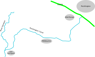
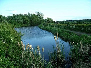
The Pocklington Canal is a broad canal which runs for 9.5 miles (15.3 km) through nine locks from the Canal Head near Pocklington in the East Riding of Yorkshire, England, to the River Derwent which it joins near East Cottingwith. Most of it lies within a designated Site of Special Scientific Interest.

The London to Portsmouth canal was a concept for the construction of a secure inland canal route from the British capital of London to the headquarters of the Royal Navy at Portsmouth. It would have allowed craft to move between the two without having to venture into the English Channel and possibly encounter enemy ships. There is no naturally navigable route between the two cities, which resulted in several schemes being suggested. The first, which was put before Parliament in 1641, was for a canal to link the River Wey and the River Arun, whose sources were only 2 miles (3.2 km) apart, but the bill was defeated. Improvements to the River Wey were authorised in 1651, and navigation was extended to Godalming in 1763. During the American War of Independence, goods was conveyed to Godalming by water, and overland from there to Portsmouth, but this ceased when the war ended.

The A286 is an A class road in the south of England, from its northernmost point in Milford, Surrey, to Birdham, West Sussex. It passes through the market towns of Haslemere and Midhurst, and the cathedral city of Chichester. The road is mostly single carriageway, with a small dual carriageway section as part of the Chichester ring road.

The current Cannock Extension Canal is a 1.8-mile (2.9 km) canal in England. It runs from Pelsall Junction on the Wyrley and Essington Canal, north to Norton Canes Docks and forms part of the Birmingham Canal Navigations. Historically, it ran to Hednesford, and served a number of collieries, which provided the main traffic. It opened in 1863, and the northern section closed in 1963, as a result of mining subsidence.

The Selby Canal is a 6-mile (9.7 km) canal with two locks, which bypasses the lower reaches of the River Aire in Yorkshire, England, from the village of West Haddlesey to the town of Selby where it joins the River Ouse. It opened in 1778, and provided the main outlet for the Aire and Calder Navigation until 1826, when it was bypassed by a new cut from Ferrybridge to Goole. Selby steadily declined after that, although traffic to York still used the canal.
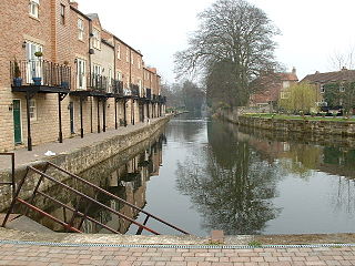
The Ripon Canal is located in North Yorkshire, England. It was built by the canal engineer William Jessop to link the city of Ripon with the navigable section of the River Ure at Oxclose Lock, from where boats could reach York and Hull. It opened in 1773 and was a moderate success. It was sold to the Leeds and Thirsk Railway in 1847 and was effectively closed by 1906 owing to neglect. It was not nationalised with most canals and railways in 1948 and was abandoned in 1956.
The Middlewich Branch of the Shropshire Union Canal is located in Cheshire, in the north west of England, and runs between Middlewich, where it joins the Trent and Mersey Canal, and Barbridge Junction, where it joins the main line of the Shropshire Union Canal. It is 10 miles (16 km) long, and was planned as part of the Chester Canal, which was authorised in 1772, but the company ran out of money, and construction did not begin until 1827. The Trent and Mersey insisted that there should be no direct connection at Middlewich, and instead built the short Wardle Canal to join the two, charging large compensation tolls for traffic passing along it.

The Donnington Wood Canal was a 5.5-mile (8.9 km) private canal in East Shropshire, England, which ran from coal pits owned by Earl Gower at Donnington Wood to Pave Lane on the Wolverhampton to Newport Turnpike Road. It was completed in about 1767 and abandoned in 1904. The canal was part of a larger network of tub-boat canals, which were used for the transport of raw materials, particularly coal, limestone and ironstone, from the locations where they were mined to furnaces where the iron ore was processed. The canal was connected to the Wombridge Canal and the Shropshire Canal.

West Itchenor is a village and civil parish, on the Manhood Peninsula, in the Chichester District of West Sussex, England. It lies north of the B2179 Chichester to West Wittering road 4.5 miles (7.3 km) southwest of Chichester. The village lies on the shores of Chichester Harbour.

The Heywood Branch Canal was a branch of the Rochdale Canal from Castleton which led to Heywood. It opened in 1834 and carried traffic until 1937. It was abandoned in 1952, along with most of the Rochdale Canal, and although the Rochdale Canal has been reopened, the junction lies under the embankments of the M62 motorway.