The Bude Canal was a canal built to serve the hilly hinterland in the Cornwall and Devon border territory in the United Kingdom, chiefly to bring lime-bearing sand for agricultural fertiliser. The Bude Canal system was one of the most unusual in Britain.[1]
It was remarkable in using inclined planes to haul tub boats on wheels to the upper levels. There were only two conventional locks, in the short broad canal section near the sea at Bude itself. It had a total extent of 35 miles (56km), and it rose from sea level to an altitude of 433 feet (132m).
The design of the canal influenced the design of the Rolle Canal.
Origins
The coastal area at Bude has sand unusually rich in minerals, and the poor agricultural land of the locality was found to benefit considerably from application of the sand. In the pre-industrial age, actually transporting it was difficult, even to land relatively close to the coast.
An Act for making a navigable Cut or Canal from the Port or Harbour of Bude, in the Hundred of Stratton, in the County of Cornwall, to the River Tamer, in the Parish of Calstoke, in the said County.
Several schemes were put forward for canals to bring the sand to the countryside, and these proposals did not lack ambition. One early scheme, conceived by Cornish engineer John Edyvean, aimed at distributing Welsh coal from the port as far inland as Calstock on the River Tamar. It gained approval for construction in the Bude Canal Act 1774 (14 Geo. 3. c. 53), but financial problems and the Napoleonic Wars frustrated the proposal.[2][3]
An Act for improving the Harbour of Bude, in the County of Cornwall; and for making and maintaining a Navigable Canal from the said Harbour of Bude to or near the Village of Thornbury, in the County of Devon, and divers Branches therefrom, all in the said Counties of Cornwall and Devon.
In 1818, the West Country canal engineer James Green produced a report for canal's backers,[4] and an act of Parliament, the Bude Harbour and Canal Act 1819 (59 Geo. 3. c. lv), was obtained for this more moderate proposal in 1819. After some difficulties in the construction phase, the canal was completed, and opened on 8 July 1823.[5] Its cost was £118,000.[6]
The canal system
The project:
improved the difficult exposed sea harbour at Bude;
built a broad canal capable of taking 50-foot (15m) barges for 2 miles (3.2km) to Helebridge Basin;
built the rest of the system for tub boats, 20 feet (6.1m) long by 5feet 6inches (1.68m) wide;
built a reservoir at Virworthy to feed water to the system.
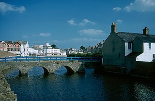
The sea lock on Bude Canal
The main line of the canal ran south east from Bude to Druxton Wharf near Launceston, with an easterly branch to Blagdonmoor, beyond Holsworthy. There was a northerly feeder arm leading from a new reservoir at Virworthy, now called Lower Tamar Lake.
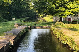
There were two conventional locks in the short broad canal section, each with a vertical interval of 5feet 6inches (1.68m). This section terminated at Helebridge, about 2 miles (3.2km) from Bude, and ordinary coastal barges travelled this far up the canal.
The tub boats were designed to use the main part of the system, and they generally made the transit from the harbour at Bude, or from Helebridge if trans-shipping from coastal vessels there.
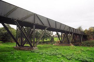
After Helebridge, there were three inclined planes to the summit section; the whole of the central part of the system was at this level, 433 feet (132m) above sea level. The main line to Druxton Wharf, near Launceston, negotiated three descending inclined planes as it followed the southerly course of the River Tamar.
With no intermediate locks on the tub boat sections, the canal had to follow the contours between the inclined planes, and this made its route even more circuitous than most canals. However, some relatively ambitious viaducts and earthworks were constructed, particularly where side streams and small valleys entered the main watercourse and its valley.
The unusual feature of the canal was the six inclined planes. The tub boats had wheels, and on the inclined planes they were pulled up the slopes with the wheels running in channel rails (like a squat letter "U" in section). There were two sets of rails, one for each direction, but it does not appear that a counterbalancing system was used (in which a boat coming down would balance one being pulled up).
The tub boats were hauled up and let down the inclined planes by chains, which were operated in most cases by waterwheels; the transit took five minutes or so. There were standby steam engines at some of the inclined planes. However the Hobbacott Inclined Plane (both the steepest and that allowing the greatest height difference) used a different system of harnessing water power: water filled a very large bucket, and it was simply the weight of the water that pulled the ascending tub boat up the incline. The bucket operated in a deep vertical shaft, and at the bottom a plug was opened and the water ran to waste along an adit which connected to the lower level of the canal; the descending bucket pulled an empty bucket up in the same operation. The full bucket had to be heavy enough to pull a loaded tub boat up the 1 in 41⁄2 gradient as well as overcoming friction, and Green calculated that a weight of about fifteen tons was necessary. This was successful, and the bucket raised a boat up the plane in about four minutes, which was about one half of the time taken when the 16 horsepower (12kW) standby steam engine was used.[4]
The gradients of the planes differed somewhat, with Hobbacott being the steepest at 1 in 4.5 and Vealand being the gentlest at 1 in 8.6.
Tub boats
The tub boats were 20 feet (6.1m) long and 5feet 6inches (1.68m) wide, and carried about 20 tons payload; the usage of tub boats was not confined to the Bude Canal. They were commonly operated by coupling between 4 and 6 together and hauling them – by horse power – together. A "train" of boats could therefore be 120 feet (37m) long, and on the very sinuous alignment of the canal, the train must have been difficult to pass round sharp curves. Steering was possible by manually altering the connection between adjacent boats, using handspikes.
Each boat had four wheels 14 inches (360mm) in diameter for running on the inclined planes; the boats were hauled up and down individually.
The operation of lining the tub boats up with the rails, at transfer from canal to plane, must have been difficult. Once engaged with the continuous chain, it would have been impracticable to stop the motion momentarily while the wheels were guided to the rail channels; but no record is available as to how this was achieved.
Operation
The sea lock at the end of the 19th century
On completion of the canal, the owning company was constantly short of cash, and inevitably income did not reach the levels predicted at the stage of promoting the canal. In addition, serious problems with the state of the newly finished works were discovered, although in the circumstances of a locally promoted scheme with novel technological aspects, the canal as built was better engineered than it might have been. The chains on the inclined planes were constantly breaking, the rails broke, and other mechanical failures were frequent, and physical damage from careless boat handling was also common.
However, the rich sand was successfully carried to farms near the various wharves in large quantities, and other merchandise was also carried, particularly coal from South Wales. Traffic picked up in the 1880s, and when the London and South Western Railway reached Holsworthy, the canal carried significant volumes of the sand to Stanbury Wharf for onward conveyance by railway; the mile or so between the wharf and the railway station must have been negotiated by horse and cart.
Nonetheless, the arrival of the railway soon spelt the ultimate doom of the canal: manufactured fertilisers had become commonplace and cheap, and they could be brought in by railway, so that the demand for the local sand was diminished considerably.
When it became obvious that the canal could not survive, some directors proposed obtaining parliamentary authority for abandonment, or selling the canal outright to the railway company, or anyone else. However, legal conditions agreed at the time of construction gave certain landowners rights to take water from the canal, and they would not give up these rights without compensation, so for the time being the proposals for disposal were frustrated. Finally, abandonment of the tub boat operation took place on 14 November 1891, with the Launceston main line and the Holsworthy branch being abandoned, but the Feeder arm continuing to be kept open because of the water rights. After protracted negotiations, the remainder of the canal was bought by Stratton and Bude Urban District Council, on 1 January 1902, and this enabled them to supply domestic water in due course to the villages in the district from the canal's Tamar reservoir. The works became the responsibility of North Cornwall District Council when English local government was reorganised in 1974.
The canal today
One of the two locks on Bude Canal where the gates have been replaced by a concrete dam. Both sets of locks going up the canal from Bude to Marhamchurch have been restored to wooden locks.
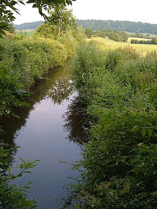
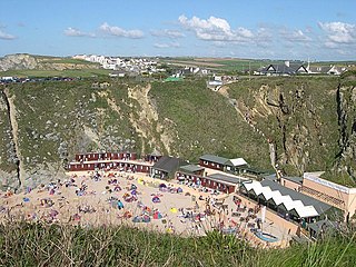
Today the sea lock is still in working order, and the canal is 'in water' as far as the base of the first inclined plane. The sea lock, though, is the only lock on this section still in working order, so that navigation is not possible along the whole network. Much of the upper section has been ploughed over or has become overgrown, but it is possible to see many remaining signs of the canal's presence, in bridges and wharf buildings. On the feeder branch and on the lower part of the Launceston main line, the alignment is indicated on current Ordnance Survey maps. In most cases, the alignment is not open to the public, however.
An exhaustive list of locations where the canal's remains can be seen may be found in Harris and Ellis.[5]
Plans for restoration
In 2005 major plans were approved to re-develop the canal, including renewal of the two locks between the sea lock and the first inclined plane. £3.8 million in funding for this project was provided by the Heritage Lottery Fund, Objective One and the South West Regional Development Agency. Most of the planned projects were completed by 31 March 2009, which was also the date on which North Cornwall District Council ceased to exist: the partners in the project expressed the hope that the new Unitary Authority would complete the three unfinished elements: raising Rodd's bridge, providing slipways at each end of the canal, and re-connecting it to Helebridge Wharf.[7]
One element of the restoration was a number of wooden sculptures by Daniel Sodhi-Miles. These are inscribed with Cornish words and phrases, and take the form of chains or parts of chains, recalling the canal's boating history.[8]
Part of a wooden sculpture by Daniel Sodhi-Miles. It is inscribed in Cornish and English with "Don’t be afraid of the sea, respect it".Second part of a wooden sculpture by Daniel Sodhi-Miles. It is inscribed in Cornish and English with "If a man could have the strength of the sea, he’d be a strong man".
March 2008 damage
On Monday 10 March 2008, a powerful storm wrenched one of the lock gates off its fixings. Contractors removed the gate the following morning, and four-tonne concrete pipes were placed in the canal basin to dissipate the power of waves coming in from the sea. A temporary dam was constructed at Falcon Bridge, and a team of anglers and staff from the Environment Agency rescued the fish population before it was swept out to sea. Beyond the dam, the loss of water was contained, with levels only dropping by about 8 inches (20cm),[9] but at the lower end of the canal water continued to flow out until it was practically empty, revealing some interesting finds in the mud, including a shotgun.[10]
The North Cornwall District Council used the opportunity to repair the canal walls and dredge the basin. During the course of the dredging, over 6,000 cubic metres (7,800cuyd) of silt were removed. It was originally intended to refill the basin gradually after 8 July 2008, but a period of intense rainfall prior to that date resulted in a surge of water passing down the canal, which damaged the coffer dam protecting the empty section from the watered section. Consequently, the basin refilled in a single day.[7]
Harris, H; Ellis, M (1972). The Bude Canal. Newton Abbot: David & Charles. ISBN978-0-7153-7018-6.
Phillips, John (1792). A general history of inland navigation, foreign and domestic (2ed.). Holborn, London: Architectural Library. OCLC433597060.
Quinlan, R (1994). Canal Walks of England and Wales. Stroud, Glos: Alan Sutton Publishing. ISBN978-0-7509-0608-1.
Whitaker, Mike (May 2008). Sea Lock Damaged by Storm. Waterways World. ISSN0309-1422.
Related Research Articles
The Liskeard and Looe Union Canal was a broad canal between Liskeard and Looe in Cornwall, United Kingdom. It was almost 6 miles (9.7 km) long and had 24 locks, and it opened progressively from 1827. The engineer was Robert Coad.
The Tamar is a river in south west England that forms most of the border between Devon and Cornwall. A large part of the valley of the Tamar is protected as the Tamar Valley National Landscape, and some is included in the Cornwall and West Devon Mining Landscape due to its historic mining activities.
Bude is a seaside town in north Cornwall, England, United Kingdom, in the civil parish of Bude-Stratton and at the mouth of the River Neet. It was sometimes formerly known as Bude Haven. It lies southwest of Stratton, south of Flexbury and Poughill, and north of Widemouth Bay, located along the A3073 road off the A39. Bude is twinned with Ergué-Gabéric in Brittany, France. Bude's coast faces Bude Bay in the Celtic Sea, part of the Atlantic Ocean. The population of the civil parish can be found under Bude-Stratton.
The Grand Western Canal ran between Taunton in Somerset and Tiverton in Devon in the United Kingdom. The canal had its origins in various plans, going back to 1796, to link the Bristol Channel and the English Channel by a canal, bypassing Lands End. An additional purpose of the canal was the supply of limestone and coal to lime kilns along with the removal of the resulting quicklime, which was used as a fertiliser and for building houses. This intended canal-link was never completed as planned, as the coming of the railways removed the need for it.
The Morris Canal (1829–1924) was a 107-mile (172 km) common carrier anthracite coal canal across northern New Jersey that connected the two industrial canals in Easton, Pennsylvania across the Delaware River from its western terminus at Phillipsburg, New Jersey to New York Harbor and New York City through its eastern terminals in Newark and on the Hudson River in Jersey City. The canal was sometimes called the Morris and Essex Canal, in error, due to confusion with the nearby and unrelated Morris and Essex Railroad.
Caldon Canal is a branch of the Trent and Mersey Canal which opened in 1779. It runs 18 miles (29 km) from Etruria, Stoke-on-Trent, to Froghall, Staffordshire. The canal has 17 locks and the 76-yard (69 m) Froghall Tunnel.
The Chard Canal was a 13.5 miles (21.7 km) tub boat canal in Somerset, England, that ran from the Bridgwater and Taunton Canal at Creech St. Michael, over four aqueducts, through three tunnels and four inclined planes to Chard. It was completed in 1842, was never commercially viable, and closed in 1868. The major engineering features are still clearly visible in the landscape.
The Shrewsbury Canal was a canal in Shropshire, England. Authorised in 1793, the main line from Trench to Shrewsbury was fully open by 1797, but it remained isolated from the rest of the canal network until 1835, when the Birmingham and Liverpool Junction Canal built the Newport Branch from Norbury Junction to a new junction with the Shrewsbury Canal at Wappenshall. After ownership passed to a series of railway companies, the canal was officially abandoned in 1944; many sections have disappeared, though some bridges and other structures can still be found. There is an active campaign to preserve the remnants of the canal and to restore the Norbury to Shrewsbury line to navigation.
The Swansea Canal was a canal constructed by the Swansea Canal Navigation Company between 1794 and 1798, running for 16.5 miles (26.6 km) from Swansea to Hen Neuadd, Abercraf in South Wales. It was steeply graded, and 36 locks were needed to enable it to rise 373 feet (114 m) over its length. The main cargos were coal, iron and steel, and the enterprise was profitable.
St Columb Canal sometimes referred to as Edyvean's Canal, was an abortive canal scheme in Cornwall, England, designed for the carriage of sea sand for use as manure. It was authorised in 1773, and part of it may have been briefly used around 1780.
The Ketley Canal was a tub boat canal that ran for about 1.5 miles (2.4 km) from Oakengates to Ketley works in Shropshire, England. The canal was built about 1788 and featured the first inclined plane in Britain. The main cargo of the canal was coal and ironstone. The inclined ceased to be used in 1816, when Ketley Works was closed, but the upper canal was not finally abandoned until the 1880s. A few traces of the canal are still visible in the landscape.
The Tavistock Canal is a canal in the county of Devon in England. It was constructed early in the 19th century to link the town of Tavistock to Morwellham Quay on the River Tamar, where cargo could be loaded into ships. The canal is still in use to supply water to a hydro-electric power plant at Morwellham Quay, and forms part of the Cornwall and West Devon Mining Landscape World Heritage Site. It is unusual for a canal, as it has a gentle slope over its length, resulting in a considerable flow of water.
The Shropshire Canal was a tub boat canal built to supply coal, ore and limestone to the industrial region of east Shropshire, England, that adjoined the River Severn at Coalbrookdale. It ran from a junction with the Donnington Wood Canal ascending the 316 yard long Wrockwardine Wood inclined plane to its summit level, it made a junction with the older Ketley Canal and at Southall Bank the Coalbrookdale (Horsehay) branch went to Brierly Hill above Coalbrookdale; the main line descended via the 600 yard long Windmill Incline and the 350 yard long Hay Inclined Plane to Coalport on the River Severn. The short section of the Shropshire Canal from the base of the Hay Inclined Plane to its junction with the River Severn is sometimes referred to as the Coalport Canal.
The Okehampton–Bude line was a railway line built to serve Holsworthy in Devon, and Bude on the Cornish coast near the Devon border in England. The line branched from the main line at Meldon Junction to the west of Okehampton on the northern edge of Dartmoor. The line opened in 1879 to Holsworthy and in 1898 to Bude. It is now closed.
The Kidwelly and Llanelly Canal was a canal and tramroad system in Carmarthenshire, Wales, built to carry anthracite coal to the coast for onward transportation by coastal ships. It began life as Kymer's Canal in 1766, which linked pits at Pwll y Llygod to a dock near Kidwelly. Access to the dock gradually became more difficult as the estuary silted up, and an extension to Llanelli was authorised in 1812. Progress was slow, and the new canal was linked to a harbour at Pembrey built by Thomas Gaunt in the 1820s, until the company's own harbour at Burry Port was completed in 1832. Tramways served a number of collieries to the east of Burry Port.
The Donnington Wood Canal was a 5.5-mile (8.9 km) private canal in East Shropshire, England, which ran from coal pits owned by Earl Gower at Donnington Wood to Pave Lane on the Wolverhampton to Newport Turnpike Road. It was completed in about 1767 and abandoned in 1904. The canal was part of a larger network of tub-boat canals, which were used for the transport of raw materials, particularly coal, limestone and ironstone, from the locations where they were mined to furnaces where the iron ore was processed. The canal was connected to the Wombridge Canal and the Shropshire Canal.
The Wombridge Canal was a tub-boat canal in Shropshire, England, built to carry coal and iron ore from mines in the area to the furnaces where the iron was extracted. It opened in 1788, and parts of it were taken over by the Shrewsbury Canal Company in 1792, who built an inclined plane at Trench. It lowered tub boats 75 feet (23 m), and remained in operation until 1921, becoming the last operational canal inclined plane in the country. The canal had been little used since 1919, and closed with the closure of the plane.
James Green (1781–1849) was a civil engineer and canal engineer, who was particularly active in the South West of England, where he pioneered the building of tub boat canals, and inventive solutions for coping with hilly terrain, which included tub boat lifts and inclined planes. Although dismissed from two schemes within days of each other, as a result of construction problems, his contribution as a civil engineer was great.
North Tamerton is a village and civil parish in east Cornwall, England, UK. The village is situated approximately eight miles (13 km) southeast of Bude and eight miles (13 km) north of Launceston.
Notes: 1 Contains canalised river. 2 Partly or mostly navigable, and/or under restoration. 3 A system of canals. Canals which form part of this system are not listed here individually.
This page is based on this Wikipedia article Text is available under the CC BY-SA 4.0 license; additional terms may apply. Images, videos and audio are available under their respective licenses.