Ripon Canal

Last updated

Ripon Canal
Ripon Canal Basin.jpg
Ripon Canal basin, at the end of the Ripon Canal
Specifications
Maximum boat length57 ft 0 in (17.37 m)
Maximum boat beam 14 ft 3 in (4.34 m)
Locks3
StatusOperational
Navigation authority Canal and River Trust
History
Original ownerRiver Ure Commissioners
Principal engineerWilliam Jessop
Date of act1767
Date of first use1773
Date closed1956
Date restored1996
Geography
Start pointRipon
End pointOxclose Lock
Connects to River Ure
Ripon Canal
BSicon WASSER.svg
River Ure
BSicon WASSER+r.svg
BSicon WASSER.svg
River Laver
BSicon WABZql.svg
BSicon WASSERq.svg
BSicon uexnKSTRa.svg
BSicon WABZg+r.svg
River Skell and Feeder
BSicon ueDOCKa.svg
BSicon WASSER.svg
Ripon Canal Basin
BSicon uSTR.svg
BSicon LWASSER.svg
River Ure
BSicon uSKRZ-Au.svg
A61 Ripon Bypass bridge
BSicon uSKRZ-Eu.svg
Footbridge
BSicon uLock5.svg
Rhodesfield Lock
BSicon uSKRZ-Eu.svg
Footbridge
BSicon uLock5.svg
Bell Furrows/Littlethorpe Lock
BSicon uSKRZ-Eu.svg
BSicon uddSTRr.svg
Footbridge and marina
BSicon uFABZgl+l.svg
BSicon uSTRr.svg
BSicon uSKRZ-Eu.svg
Nicholsons Bridge
BSicon uddHSTRf.svg
BSicon uFABZgr+r.svg
Ripon MBC marina
BSicon uLock5.svg
Oxclose Lock
BSicon uSTR.svg
BSicon WASSER+l.svg
BSicon LWASSERr.svg
River Ure
BSicon POINTERg@fq.svg
BSicon uSTR.svg
River Ure

The Ripon Canal is located in North Yorkshire, England. It was built by the canal engineer William Jessop to link the city of Ripon with the navigable section of the River Ure at Oxclose Lock, from where boats could reach York and Hull. It opened in 1773 and was a moderate success. It was sold to the Leeds and Thirsk Railway in 1847 and was effectively closed by 1906 owing to neglect. It was not nationalised with most canals and railways in 1948 and was abandoned in 1956.

Contents

In 1961 members of the Ripon Motor Boat Club formed the Ripon Canal Company Ltd and gradually restored the canal up to Littlethorpe. Subsequently the Ripon Canal Society spearheaded restoration, which was completed in 1996. It is now managed by the Canal & River Trust.

History

The building of the Ripon Canal was authorised by an Act of Parliament passed on 15 April 1767, and the canal was the final part of a larger plan to upgrade the River Ure from its junction with the River Swale to Oxclose, where the canal would leave the river and head for Ripon, some 2.3 miles (3.7 km) away. Below the Swale the Ure becomes the River Ouse, and so carriage of goods to and from York and Hull would be possible. [1] The estimated cost of the whole project was £9,000, and the Act established Commissioners, who could borrow money in order to fund the development although the total amount of money to be borrowed was not regulated by the Act. The works were designed to allow the passage of keels, which were 58 by 14.5 feet (17.7 by 4.4 m). [2]

Work started first on the lower sections, which were progressively opened from 1767. The canal route was surveyed by William Jessop and work on its construction started in 1770, with Jessop acting as Engineer, supervised by John Smeaton. The engineer overseeing the day-to-day operation was John Smith, and a masonry contractor from Halifax called Joshua Wilson was also employed. Construction was completed in early 1773, at a cost of £16,400, and regular services between Ripon and York started in February. The canal was fed with water by a feeder that left the Rivers Laver and Skell in Ripon. [2] One of the primary purposes of the canal was the carriage of coal to Ripon, north from the Yorkshire coalfields, with lead and agricultural produce moving in the opposite direction. [1]

Trade on the canal grew steadily, but there were difficulties by the 1820s, as the commissioners had failed to repay the original loans and interest totalling £11,450 had accrued on them. [3] The original Commissioners had ceased to function, and so a group of creditors formed "The Company of Proprietors of the River Ure Navigation to Ripon", and obtained a second Act of Parliament on 23 June 1820, which gave them powers to raise £34,000 by the issuing of shares, with an extra £3,400 if needed. They were required to spend £3,000 on repairs within five years of the Act being issued. [1]

Improvements were made, both as a result of the Act and separately in 1838, which resulted in larger boats being able to negotiate the canal. Payloads increased from 30 tonnes in 1822 to 70 tonnes in the 1840s, when the navigation could accommodate boats drawing 4.5 feet (1.4 m) all the way to Ripon. It was never able to handle the Humber sloops, which ran as far as Boroughbridge, with their width of 15.8 feet (4.8 m) and draught of 6.5 feet (2.0 m). [3]

Despite the railway from Darlington to York opening on 4 January 1841, which provided a way to bring coal from the Durham Coalfields south to York, the Aire and Calder Canal were shipping around 26,931 tonnes of coal per year along the Ure Navigation at the time, and the Company of Proprietors was making profits of £886 on an income of £2,013. Some of this traffic stopped at Boroughbridge on the River Ure but a good proportion passed along the canal to Ripon. [3]

Decline

1844 marked a turning point for the canal. The Leeds and Thirsk Railway Company wanted to build their railway and sought to buy the Ure Navigation, and hence the canal, in order to gain local support for their plans and in the hope of reducing the potential opposition to their bill in parliament. The sale was agreed between the two Boards and the railway Company's shareholders endorsed the decision in January 1845. An Act of Parliament to authorise the railway was obtained in July 1845, and the Navigation was bought for £34,577 in January 1846, although only £16,297 was paid in cash. The Act required the railway Company to keep the navigation open and in good order. [4]

Railway expansion was rapid, with the Leeds and Thirsk Railway becoming the Leeds Northern Railway, and then that becoming part of the North Eastern Railway in 1854. The navigation was neglected and the lack of dredging resulted in boats having to be loaded with less cargo. There was a brief upturn in trade in the 1860s but the decline continued after that. By 1892 no traffic proceeded past Boroughbridge and the Ripon Canal was effectively disused. The first attempt to abandon the waterway was made by the North Eastern Railway in 1894 but local opposition prevented it. It was then offered to the Corporation of York as a gift but was not accepted. The NER then took action to prevent the waterway above Boroughbridge being used, [4] and the canal was reported to be impassable by 1906. The River Ouse, and therefore the canal, were not nationalised in 1948 when most British canals were, but with no traffic the canal was officially abandoned in 1956, [5] under the terms of the British Transport Commission Act of 1955. [4]

Restoration

Although an offer by the British Transport Commission to sell the canal to Ripon Corporation in 1952 had been declined, [6] closure of the canal was unpopular locally and such opposition prevented the canal from being filled in. In 1961 the Ripon Canal Company Ltd was formed, consisting largely of people who were part of the Ripon Motor Boat Club, with the intention of leasing the canal and gradually reopening it. The lower half from Oxclose Lock to Littlethorpe was finally restored to use 25 years later. [5] To assist with the restoration of the section from Littlethorpe Lock to Ripon the Inland Waterways Association managed to have the idea included in North Yorkshire County Council's "River Ure and Ouse Recreational Subject Plan". The Council suggested that a restoration society should push this forwards and so the Ripon Canal Society was formed in 1983. [7] The restoration was finally completed in 1996 and David Curry MP declared it open at a ceremony held on 8 September. With their task completed the Ripon Canal Society disbanded at their 1997 annual general meeting, giving the remains of their funds towards the repair of Linton Lock lower down the River Ure. [8] Management of the canal was handed over to British Waterways [5] and transferred to the Canal & River Trust in 2012.

Features

Ripon was said to be the most northerly point of the connected British canal system, a claim that was affected by the opening of the Ribble Link in 2002. The Lancaster Canal is now considered to be part of the connected canal system and Tewitfield, at its northern end, now qualifies for this accolade. [5]

The canal terminates at a basin close to the centre of Ripon, where one of the warehouses has been restored. New housing on one side of the basin has been designed to fit in sympathetically and there is some older housing on the other side. [9] There are no moorings in the terminal basin itself but short-term mooring is available just to the south. There is also a marina near Ripon Racecourse. The canal is only 2.3 miles (3.7 km) long, and the entire length has a canalside walk, which utilises the towpath from Rhodesfield Lock to Oxclose Lock, although the towpath cannot be used by cyclists. [5]

Points of interest

Map all coordinates using: OpenStreetMap  
Download coordinates as: KML

See also

Related Research Articles

Lancaster Canal Canal in Northwest England

The Lancaster Canal is a canal in North West England, originally planned to run from Westhoughton in Lancashire to Kendal in south Cumbria. The section around the crossing of the River Ribble was never completed, and much of the southern end leased to the Leeds and Liverpool Canal, of which it is now generally considered part.

Calder and Hebble Navigation Inland waterway in West Yorkshire, England

The Calder and Hebble Navigation is a broad inland waterway, with locks and bridgeholes that are suitable for 14-foot-wide (4.3 m) boats, in West Yorkshire, England. Construction to improve the River Calder and the River Hebble began in 1759, and the initial scheme, which included 5.7 miles (9.2 km) of new cuts, was completed in 1770 and has remained navigable since it was opened. Significant improvements were made, including the Salterhebble branch to Halifax, opened in 1828, and ever-longer cuts to bypass river sections. Trade was assisted by the opening of the Rochdale Canal in 1804, which provided a through route from Sowerby Bridge to Manchester. There were plans to abandon the river sections completely in the 1830s, but these were modified as the needs of mill owners and other riparian landowners were recognised.

Aire and Calder Navigation Canal in West Yorkshire, England

The Aire and Calder Navigation is the canalised section of the Rivers Aire and Calder in West Yorkshire, England. The first improvements to the rivers above Knottingley were completed in 1704 when the Aire was made navigable to Leeds and the Calder to Wakefield, by the construction of 16 locks. Lock sizes were increased several times, as was the depth of water, to enable larger boats to use the system. The Aire below Haddlesey was bypassed by the opening of the Selby Canal in 1778. A canal from Knottingley to the new docks and new town at Goole provided a much shorter route to the River Ouse from 1826. The New Junction Canal was constructed in 1905, to link the system to the River Don Navigation, by then part of the Sheffield and South Yorkshire Navigation.

Barnsley Canal Canal that ran from Barnby Basin, through Barnsley, South Yorkshire, England

The Barnsley Canal is a canal that ran from Barnby Basin, through Barnsley, South Yorkshire, England to a junction with the Aire and Calder Navigation near Wakefield, West Yorkshire. It was built in the 1790s, to provide a transport link from coal reserves at Barnsley to a wider market. Both the Aire and Calder Navigation and the River Don Navigation took a keen interest in the project, the former buying many of the initial shares, and the latter constructing the Dearne and Dove Canal to link the canal to their waterway. Water supply issues meant that the Aire and Calder proposed pumping all of the water for the canal from the River Calder, using steam pumps, but a reservoir was built at Cold Hiendley instead, increasing the construction costs, but reducing the running costs. The canal as built was 14.5 miles (23.3 km) long and included 15 locks.

Chester Canal English canal linking the south Cheshire town of Nantwich with the River Dee at Chester

The Chester Canal was an English canal linking the south Cheshire town of Nantwich with the River Dee at Chester. It was intended to link Chester to Middlewich, with a branch to Nantwich, but the Trent and Mersey Canal were unco-operative about a junction at Middlewich, and so the route to Nantwich was opened in 1779. There were also difficulties negotiating with the River Dee Company, and with no possibility of through traffic, the canal was uneconomic. Part of it was closed in 1787, when Beeston staircase locks collapsed, and there was no money to fund repairs. When the Ellesmere Canal was proposed in 1790, the company saw it as a ray of hope, and somehow managed to keep the struggling canal open. The Ellesmere Canal provided a link to the River Mersey at Ellesmere Port from 1797, and the fortunes of the Chester Canal began to improve.

Grantham Canal Canal once running between Grantham and Nottingham

The Grantham Canal ran 33 miles (53 km) from Grantham through 18 locks to West Bridgford, where it joined the River Trent. It was built primarily for the transportation of coal to Grantham. It opened in 1797 and its profitability steadily increased until 1841. It was then sold to a railway company, declined, and was finally closed in 1936. It was used as a water supply for agriculture, and so most of it remained in water after closure, although bridges were lowered. Since the 1970s, the Grantham Canal Society have been working to restore parts of it. Two stretches are now navigable to small vessels. A new route will be required where the canal joins the Trent, as road building has severed the original one.

Wey and Arun Canal

The Wey and Arun Canal is a partially open, 23-mile-long (37 km) canal in the southeast of England. It runs southwards from the River Wey at Gunsmouth, Shalford, Surrey to the River Arun at Pallingham, in West Sussex. The canal comprises parts of two separate undertakings – the northern part of the Arun Navigation, opened in 1787 between Pallingham and Newbridge Wharf, and the Wey and Arun Junction Canal, opened in 1816, which connected the Arun at Newbridge to the Godalming Navigation near Shalford, south of Guildford. The Arun Navigation was built with three locks and one turf-sided flood lock. The Junction Canal was built with 23 locks

Montgomery Canal Canal in Shropshire, England, and Powys, Wales

The Montgomery Canal, known colloquially as "The Monty", is a partially restored canal in eastern Powys and northwest Shropshire. The canal runs 33 miles (53 km) from the Llangollen Canal at Frankton Junction to Newtown via Llanymynech and Welshpool and crosses the England–Wales border.

Dearne and Dove Canal Canal in South Yorkshire, England

The Dearne and Dove Canal ran for almost ten miles through South Yorkshire, England from Swinton to Barnsley through nineteen locks, rising 127 feet (39 m). The canal also had two short branches, the Worsbrough branch and the Elsecar branch, both about two miles long with reservoirs at the head of each. The Elsecar branch also has another six locks. The only tunnel was bypassed by a cutting in 1840.

Droitwich Canal

The Droitwich Canal is a synthesis of two canals in Worcestershire, England; the Droitwich Barge Canal and the Droitwich Junction Canal. The Barge Canal is a broad canal which opened in 1771 linking Droitwich Spa to the River Severn at Hawford Bottom Lock, Claines. The Droitwich Junction Canal is a narrow canal, opened in 1854, which linked Droitwich to the Worcester and Birmingham Canal. Both were built to carry salt, and were abandoned in 1939. They have been the subject of a restoration plan since 1973, and the Barge Canal was officially reopened in 2010, while the Junction Canal reopened in July 2011. Following the opening of the canal, ownership transferred to the newly created Canal and River Trust

Rochdale Canal

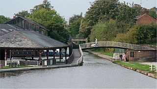
The Rochdale Canal is in Northern England, between Manchester and Sowerby Bridge, part of the connected system of the canals of Great Britain. Its name refers to the town of Rochdale through which it passes.

River Ure River in North Yorkshire, England

The River Ure in North Yorkshire, England is approximately 74 miles (119 km) long from its source to the point where it becomes the River Ouse. It is the principal river of Wensleydale, which is the only major dale now named after a village rather than its river. The old name for the valley was Yoredale after the river that runs through it.

Driffield Navigation

The Driffield Navigation is an 11-mile (18-kilometre) waterway, through the heart of the Holderness Plain to the market town of Driffield, East Riding of Yorkshire, England. The northern section of it is a canal, and the southern section is part of the River Hull. Construction was authorised in 1767, and it was fully open in 1770. Early use of the navigation was hampered by a small bridge at Hull Bridge, which was maintained by Beverley Corporation. After protracted negotiation, it was finally replaced in 1804, and a new lock was built to improve water levels at the same time. One curious feature of the new works were that they were managed quite separately for many years, with the original navigation called the Old Navigation, and the new works called the New Navigation. They were not fully amalgamated until 1888.

Sheffield & Tinsley Canal

The Sheffield & Tinsley Canal is a canal in the City of Sheffield, England. It runs 3.9 miles (6.3 km) from Tinsley, where it leaves the River Don, to the Sheffield Canal Basin in the city centre, passing through 11 locks. The maximum craft length that can navigate this lock system is 61 feet 6 inches (18.75 m) with a beam of 15 feet 6 inches (4.72 m).

Market Weighton Canal Canal in the East Riding of Yorkshire, England

The Market Weighton Canal ran 9.5 miles (15.3 km) from the Humber Estuary to its terminus near Market Weighton. It gained its Act of Parliament in 1772 and opened in 1782. The 3.5 miles (5.6 km) closest to Market Weighton was abandoned in 1900 and the right of navigation through Weighton lock was lost in 1971. However, as of 2002 the lock was passable and the canal usable up to the junction with the River Foulness where silt has made it impassable. Also there is no right of navigation under the M62 motorway bridge to the north of Newport.

Stourbridge Canal

The Stourbridge Canal is a canal in the West Midlands of England. It links the Staffordshire and Worcestershire Canal with the Dudley Canal, and hence, via the Birmingham Canal Navigations, to Birmingham and the Black Country.

Stainforth and Keadby Canal Canal in Yorkshire and Lincolnshire, England

The Stainforth and Keadby Canal is a navigable canal in South Yorkshire and Lincolnshire, England. It connects the River Don Navigation at Bramwith to the River Trent at Keadby, by way of Stainforth, Thorne and Ealand, near Crowle. It opened in 1802, passed into the control of the River Don Navigation in 1849, and within a year was controlled by the first of several railway companies. It became part of the Sheffield and South Yorkshire Navigation, an attempt to remove several canals from railway control, in 1895. There were plans to upgrade it to take larger barges and to improve the port facilities at Keadby, but the completion of the New Junction Canal in 1905 made this unnecessary, as Goole could easily be reached and was already a thriving port.

Pocklington Canal

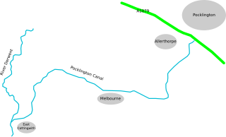
The Pocklington Canal is a broad canal which runs for 9.5 miles (15.3 km) through nine locks from the Canal Head near Pocklington in the East Riding of Yorkshire, England, to the River Derwent which it joins near East Cottingwith. Most of it lies within a designated Site of Special Scientific Interest.

Selby Canal

The Selby Canal is a 6-mile (9.7 km) canal with 2 locks which bypasses the lower reaches of the River Aire in Yorkshire, England, from the village of West Haddlesey to the town of Selby where it joins the River Ouse. It opened in 1778, and provided the main outlet for the Aire and Calder Navigation until 1826, when it was bypassed by a new cut from Ferrybridge to Goole. Selby steadily declined after that, although traffic to York still used the canal.

Tuel Lane Lock

Tuel Lane Lock is a canal lock, situated on the Rochdale Canal in Sowerby Bridge, England. It was built in 1996 as part of the canal's restoration, and replaces two previous locks, locks 3 and 4, from the original canal system. With a fall of 19 feet 8.5 inches (6 m), it is the deepest lock in the United Kingdom.

References

  1. 1 2 3 Priestley 1831 , pp. 648–650
  2. 1 2 Hadfield 1972 , pp. 111–112
  3. 1 2 3 Hadfield 1973 , pp. 345–347
  4. 1 2 3 Hadfield 1973 , pp. 450–452
  5. 1 2 3 4 5 Cumberlidge 2009 , pp. 253–254
  6. Squires 2008 , p. 31
  7. Squires 2008 , p. 112
  8. Squires 2008 , p. 140
  9. Nicholson 2006 , p. 83

Bibliography

Coordinates: 54°07′57″N1°31′06″W / 54.13246°N 1.51845°W / 54.13246; -1.51845