Portsmouth and Arundel Canal

Last updated • 5 min readFrom Wikipedia, The Free Encyclopedia

50°51′22″N0°33′32″W / 50.856°N 0.559°W / 50.856; -0.559

Contents

Towing path and canal bed of the Portsmouth and Arundel Canal near Woodgate, Sussex Portsmouth Arundel Canal Woodagte.jpg
Towing path and canal bed of the Portsmouth and Arundel Canal near Woodgate, Sussex

The Portsmouth and Arundel Canal was a canal in the south of England that ran between Portsmouth and Ford in the Arundel district, it was built in 1823 but was never a financial success and was abandoned in 1855; the company was wound up in 1888. [1] The canal was part of a larger scheme for the construction of a secure inland canal route from London to Portsmouth, which allowed craft to move between the two without having to venture into the English Channel and possibly encounter enemy ships or natural disaster. It was built by the Portsmouth & Arundel Navigation company. The canal was made up of three sections: a pair of ship canals, one on Portsea Island and one to Chichester, and a barge canal that ran from Ford on the River Arun to Hunston where it joined the Chichester section of the canal

Ford to Hunston Section

This section of the canal connected the river Arun at Ford to the junction with the Chichester arm of the canal. [2] It had two locks at Ford to allow the canal to drop 12 feet down to the river. [2]

Hunston to Birdham Section

This section (technically the Ship Canal) links Chichester Harbour at Birdham with the junction at Hunston. [3] It contains two locks Casher's or Manhood End Lock and Saltern's sea lock. [3] The canal was built to ship canal standards and was built 8 feet deep and 46 feet 8 inches wide. [3]

Chichester Ship Canal

The Chichester ship (or Barge) canal ran from the sea lock at Birdham to the junction of the Portsmouth and Arundel Canal at Hunston and then North to a basin in the south of the city of Chichester. [4]

The Portsea Canal section

A map of the route of Portsmouth and Arundel Canal across Portsea Island from 1815 Portsea islandcanal1815.jpg
A map of the route of Portsmouth and Arundel Canal across Portsea Island from 1815

This section of the canal ran from Langstone Harbour, across the east and central areas of Portsea Island through Milton, Fratton and Landport ending at a canal basin on what is now Arundel Street, which was named after the canal. [5] This section of the canal was built to what were then small ship canal standards and could take ships of up to 150 tons. [6] There were 2 locks at Milton (a sea lock and an upper lock)

The tidal channels

The Portsea section was connected to the rest via a 13-mile channel dredged through Chichester Harbour, past the southern side of Thorney Island (original plan was to go around the northern side) and to the north of Hayling Island, and finally across Langstone Harbour. [7] To ease passage between the Chichester and the Portsea sections a steam vessel, the Egremont, was made to tow 40-ton barges in trains of six. [8] For a while the company also made Portsbridge Creek navigable. [9]

History

Planning and construction

Portsmouth and Arundel Navigation Act 1817
Act of Parliament
Coat of Arms of the United Kingdom (1816-1837).svg
Long title An Act for making and maintaining a Navigable Canal from the River Arun to Chichester Harbour, and from thence to Langstone and Portsmouth Harbours, with a Cut or Branch from Hunston Common to or near the City of Chichester; and for improving the Navigation of the Harbour of Langstone and Channels of Langstone and Thorney.
Citation 57 Geo. 3. c. lxiii
Dates
Royal assent 7 July 1817
Text of statute as originally enacted
Portsmouth and Arundel Navigation Act 1828
Act of Parliament
Coat of Arms of the United Kingdom (1816-1837).svg
Long title An Act for granting further Powers to the Company of Proprietors of the Portsmouth and Arundel Navigation.
Citation 9 Geo. 4. c. lvii
Dates
Royal assent 23 May 1828
Text of statute as originally enacted
The seal of the Portsmouth and Arundel navigation company P&Aseal.PNG
The seal of the Portsmouth and Arundel navigation company

The plan for the canal was completed in 1815 and the act of Parliament, the Portsmouth and Arundel Navigation Act 1817 (57 Geo. 3. c. lxiii), passed in 1817. [10] At this stage costs were estimated at £119,000 rising to £125,452 in 1818. [11] Construction started in 1818 and the canal was finished in 1823, at a cost of £170,000. The resident engineer was James Hollinsworth who was paid £500 per annum. [12]

To supply the canal with water a pumping engine was installed at Ford to pump water from the Arun. [2] Since the Arun is tidal at Ford the act of Parliament only allowed water to be taken from the river between two hours after high water and one hour after low. [2] This was to prevent salt water from entering the canal. [2] In order to allow the passage of masted ships iron swing bridges were fitted to the Chichester and Portsea sections rather than the more typical hump back canal bridge. [11]

Operation

From the beginning the canal was plagued with various problems, and in 1827 the Portsea section of the canal had to be drained due to complaints about salt water contamination in some of Portsmouth's wells. In 1845 parts of this section were sold to the London and Brighton railway company with another section being sold to the company in 1851. [11]

In 1830 tolls were reduced and for a while traffic picked up with cargoes including 20 tons of marble from the Mediterranean for the king. In the same year the company made Ports Creek navigable to allow the passage of barges around the north of Portsea Island to Portsmouth Harbour. [9] The canal was also used to transport gold and silver for the Bank of England. [13] The canal was unable to compete with the sea routes and by 1832 the canal company was being forced to do the carrying itself. By 1847 the canal, with the exception of the Chichester arm, had ceased to be navigable. [14]

Later activities

The remains of the sea lock at the end of the Portsea section Portsea canal lock.JPG
The remains of the sea lock at the end of the Portsea section

On the remaining Portsea Section the issue of maintaining the various bridges became an issue of concern until the company managed to buy itself out of the requirement to maintain them. [11]

The Chichester arm was transferred to the Corporation of Chichester by Chichester Canal Transfer Act 1892 (55 & 56 Vict. c. cxxxviii), the same year in which the canal company was wound up (the winding up order having been applied for in 1888).

Post canal company

Some visible remains of the Portsea Section still exist in 2011. A section of the Portsmouth-London mainline railway follows the course of the canal between Portsmouth & Southsea and Fratton stations. Beyond them Goldsmith Avenue was constructed along the line of the canal. [15] Off Goldsmith Avenue, the east-west route of the canal can still be traced by more recent residential development along Old Canal and Towpath Mead roads. The tow-path follows the course of the foot-path just north of the caravan site and allotments on the south side of Locksway Road at its easternmost end, with the canal to the north side of this. There is evidence that the canal was filled in here with coke from the local gas works. The remains of the lock into Langstone Harbour are also still in evidence. [16] The lock has been a conservation area since 1977 and is a grade II listed structure. [16] In 1979 Portsmouth City Council agreed to spend £35,000 over the next decade to refurbish the lock. [17]

See also

Map of section of the canal between the Chichester branch and the River Arun P&A betweenChichesterandArundelreduced.png
Map of section of the canal between the Chichester branch and the River Arun

Related Research Articles

<span class="mw-page-title-main">Littlehampton</span> Town in West Sussex, England

Littlehampton is a town, seaside resort and civil parish in the Arun District of West Sussex, England. It lies on the English Channel on the eastern bank of the mouth of the River Arun. It is 52 miles (84 km) south south-west of London, 19 miles (31 km) west of Brighton and 10 miles (16 km) east of Chichester.

<span class="mw-page-title-main">River Arun</span> River in West Sussex, England

The River Arun is a river in the English county of West Sussex. At 37 miles (60 km) long, it is the longest river entirely in Sussex and one of the longest starting in Sussex after the River Medway, River Wey and River Mole. From the series of small streams that form its source in the area of St Leonard's Forest in the Weald, the Arun flows westwards through Horsham to Nowhurst where it is joined by the North River. Turning to the south, it is joined by its main tributary, the western River Rother, and continues through a gap in the South Downs to Arundel to join the English Channel at Littlehampton. It is one of the faster flowing rivers in England, and is tidal as far inland as Pallingham Quay, 25.5 miles (41.0 km) upstream from the sea at Littlehampton. The Arun gives its name to the Arun local government district of West Sussex.

<span class="mw-page-title-main">River Rother, West Sussex</span> River in Hampshire and West Sussex, England

The River Rother flows from Empshott in Hampshire, England, to Stopham in West Sussex, where it joins the River Arun. At 52 kilometres (32 mi) long, most of the river lies within West Sussex except for the first 10 kilometres (6.2 mi) which lie in Hampshire. The upper river, from its source to Midhurst, has been used to power watermills, with the earliest recorded use being in 1086, when the Domesday survey was conducted. Although none are still operational, many of the buildings which housed the mills still exist, and in some cases, still retain their milling machinery. This upper section is also noted for a number of early bridges, which have survived since their construction in the fifteenth, sixteenth and seventeenth centuries.

<span class="mw-page-title-main">Wey and Arun Canal</span> Canal in England

The Wey and Arun Canal is a partially open, 23-mile-long (37 km) canal in the southeast of England. It runs southwards from the River Wey at Gunsmouth in Shalford, Surrey to the River Arun at Pallingham, in West Sussex. The canal comprises parts of two separate undertakings – the northern part of the Arun Navigation, opened in 1787 between Pallingham and Newbridge Wharf, and the Wey and Arun Junction Canal, opened in 1816, which connected the Arun at Newbridge to the Godalming Navigation near Shalford, south of Guildford. The Arun Navigation was built with three locks and one turf-sided flood lock. The Junction Canal was built with 23 locks

<span class="mw-page-title-main">Chichester Canal</span> Canal in Chichester, England

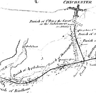
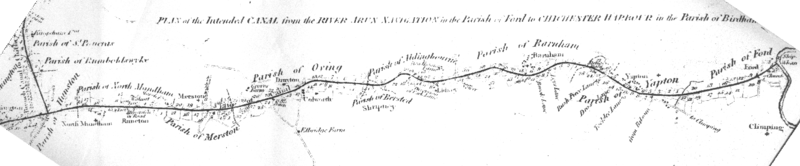
The Chichester Canal is a ship canal in England. Partly navigable, its course is essentially intact and runs 3.8 miles (6.1 km) from the sea at Birdham on Chichester Harbour to Chichester through two locks. The canal was opened in 1822 and took three years to build. The canal could take ships of up to 100 long tons (100 t). Dimensions were limited to 85 feet long, 18 feet (5.5 m) wide and a draft of up to 7 feet (2.1 m). As denoted by the suffix -chester, Chichester is a Roman settlement, and 300 Denarii were unearthed when Chichester Basin was formed in the 1820s.

<span class="mw-page-title-main">Baybridge Canal</span> United Kingdom legislation

The Baybridge Canal was a short canal built entirely within the parish of West Grinstead in the English county of Sussex. It opened in 1826, and closed in 1875.

The West Sussex Railway was a 8 and a quarter miles long standard gauge light railway between Chichester and Selsey, in West Sussex. The line, which opened in 1897, was also known as Hundred of Manhood and Selsey Tramway. It was opened as a rail tramway in order to avoid having to comply with regulations that managed conventional railways in the United Kingdom. The line was built under the auspices of the light railway entrepreneur, Colonel Stephens, who would later manage the line as the West Sussex Railway.

<span class="mw-page-title-main">Langstone, Hampshire</span> Village in Hampshire, England

Langstone is a village near Havant, Hampshire in the south east of England in Portsmouth. It has good railway connections to London, Southampton, Portsmouth and Brighton, from the nearby Havant railway station. There are many large gated detached houses on the main road, "Langstone Road" and on the roads surrounding this. It has a sailing club, several architecturally unusual buildings, and several historically significant buildings, including a converted (water) millhouse and a converted 18th century windmill, the latter of which is a local landmark.

<span class="mw-page-title-main">West Coastway line</span> Railway line in England

The West Coastway line is a railway line in England linking the conurbations of Brighton/Hove/Littlehampton and Southampton/Portsmouth, with 1.3 million people between them. It has short southward branches to Littlehampton and Bognor Regis, which offer direct services to and from London.

<span class="mw-page-title-main">Arun Valley line</span> Railway line in the UK

The Arun Valley line, also known as the Mid Sussex line, is part of the Southern- and Thameslink-operated railway services. For the initial part of the route trains follow the Brighton Main Line, and at a junction south of Three Bridges the route turns westwards. It then runs via Crawley, Horsham and Arundel, before meeting the West Coastway line at Arundel Junction. Trains on the Arun Valley line then mostly proceed to either Bognor Regis or Portsmouth Harbour, with an additional peak hour service which first proceeds to Littlehampton, and subsequently to Bognor Regis.

<span class="mw-page-title-main">Langstone Harbour</span> Site of Special Scientific Interest in Hampshire

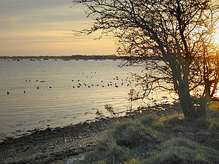
Langstone Harbour is a 2,085.4-hectare (5,153-acre) biological Site of Special Scientific Interest in Hampshire. It is an inlet of the English Channel in Hampshire, sandwiched between Portsea Island to the south and west, Hayling Island to the south and east, and Langstone to the north. It is part of the Ramsar site of Langstone and Chichester Harbour Special Protection Area and Nature Conservation Review site. Parts are Special Areas of Conservation, or Local Nature Reserves, and some areas by the Hampshire and Isle of Wight Wildlife Trust.

<span class="mw-page-title-main">Arundel railway station</span> Railway station in West Sussex, England

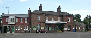
Arundel railway station serves the market town of Arundel in West Sussex. The station is on the eastern side of the town, about 550 yards (500 m) from the High Street, across the River Arun. It is 58 miles 28 chains (93.9 km) down the line from London Bridge via Redhill.

<span class="mw-page-title-main">George Wyndham, 3rd Earl of Egremont</span> British peer, landowner and art collector

George O'Brien Wyndham, 3rd Earl of EgremontFRS of Petworth House in Sussex and Orchard Wyndham in Somerset, was a British peer, a major landowner and a great art collector. He was interested in the latest scientific advances. He was an agriculturist and a friend of the agricultural writer Arthur Young, and was an enthusiastic canal builder who invested in many commercial ventures for the improvement of his estates. He played a limited role in politics.

Milton is a residential area of the English city of Portsmouth, Hampshire, England, on the south eastern side of Portsea Island. Milton is bordered on the eastern coast of Portsea Island by Langstone Harbour, with Eastney to the south-east, Southsea to the south-west, Baffins to the north and Fratton to the north-west.

<span class="mw-page-title-main">London to Portsmouth canal</span>

The London to Portsmouth canal was a concept for the construction of a secure inland canal route from the British capital of London to the headquarters of the Royal Navy at Portsmouth. It would have allowed craft to move between the two without having to venture into the English Channel and possibly encounter enemy ships. There is no naturally navigable route between the two cities, which resulted in several schemes being suggested. The first, which was put before Parliament in 1641, was for a canal to link the River Wey and the River Arun, whose sources were only 2 miles (3.2 km) apart, but the bill was defeated. Improvements to the River Wey were authorised in 1651, and navigation was extended to Godalming in 1763. During the American War of Independence, goods was conveyed to Godalming by water, and overland from there to Portsmouth, but this ceased when the war ended.

<span class="mw-page-title-main">Petworth Canal</span> Canal in West Sussex, England

The Petworth Canal was one of Britain's shorter lasting canals, opened in 1795 and dismantled in 1826. Upon completion of the Rother Navigation, the Earl of Egremont used his estate workforce to build the 1¼ mile long canal from just upstream of the Shopham Cut to Haslingbourne, with two locks, each with a rise of 8 feet and 6 inches. The Haslingbourne Stream was diverted to provide the water supply, and still flows in the canal bed from Haslingbourne to the site of Haines Lock. The initial intention was to extend the canal through the Shimmings Valley to Hamper's Green on the north side of Petworth, then northwards to join the Wey Navigation at Shalford.

<i>Chichester Canal</i> (painting) Painting by J. M. W. Turner

Chichester Canal is a painting by the English Romantic landscape painter, watercolourist and printmaker J. M. W. Turner. It was painted in 1828 and was commissioned by George Wyndham, 3rd Earl of Egremont. It is now in the Tate Collection.

The New Lipchis Way is a 60.8 kilometres (37.8 mi) long distance footpath which runs from Liphook in Hampshire to West Wittering in West Sussex. Running north–south across the Western Weald and South Downs to the Sussex coastal plain and Chichester Harbour the path crosses several geological rock strata and their associated soils and habitats. Landmarks on the route include Cowdray ruins, Goodwood Racecourse, the Trundle, Chichester Cathedral and the city walls, and East Head at West Wittering.

<span class="mw-page-title-main">Portsbridge Creek</span> Tidal waterway of Hampshire, England

Portsbridge Creek, known officially as Portsea Creek, formerly as Portsea Lake and informally as Ports Creek, Port Creek, Portcreek and Canal Creek, is a tidal waterway just off the southern coast of England that runs between Portsea Island and the mainland from Langstone Harbour to Tipner Lake.

The Portsmouth to Brighton Railway was built by the London, Brighton and South Coast Railway and its immediate predecessor in several stages.

References

  1. Armstrong, J.R. (1971). A History of Sussex. Sussex: Phillimore. pp. 144–145. ISBN   0-85033-185-4.
  2. 1 2 3 4 5 Green, Alan H.J (2006). The History of Chichester's Canal. Sussex Industrial Archaeology Society. pp. 18–19. ISBN   0-9512036-1-4.
  3. 1 2 3 Green, Alan H.J (2006). The History of Chichester's Canal. Sussex Industrial Archaeology Society. pp. 21–23. ISBN   0-9512036-1-4.
  4. Green, Alan H.J (2006). The History of Chichester's Canal. Sussex Industrial Archaeology Society. pp. 24–25. ISBN   0-9512036-1-4.
  5. Cuthbert, Ted (1988). Portsmouth's Lost Canal. Environmental Education Project. p. 16.
  6. Vine, P.A.L. (1994). London to Portsmouth Waterway. Middleton Press. p. 118. ISBN   1-873793-43-X.
  7. P.A.L Vine Hampshire Waterways page 109 ISBN   0-906520-84-3
  8. Cuthbert, Ted (1988). Portsmouth's Lost Canal. Environmental Education Project. p. 30.
  9. 1 2 Vine, P.A.L (1990). Hampshire waterways. Middleton press. p. 103. ISBN   0-906520-84-3.
  10. Cuthbert, Ted (1988). Portsmouth's Lost Canal. Environmental Education Project. pp. 9–10.
  11. 1 2 3 4 Cuthbert, Ted (1988). Portsmouth's Lost Canal. Environmental Education Project.
  12. Green, Alan H.J (2006). The History of Chichester's Canal. Sussex Industrial Archaeology Society. pp. 12–13. ISBN   0-9512036-1-4.
  13. F. D. Heneghan The Chichester Canal page 14
  14. P.A.L. Vine West Sussex waterways ISBN   0-906520-24-X
  15. Russell, Ronald (1971). Lost canals of England and Wales. David and Charles. p. 53. ISBN   0715354175.
  16. 1 2 "2.0 The character of conservation areas" (PDF). Portsmouth city council. 25 October 2006. p. 12. Archived from the original (PDF) on 27 September 2011. Retrieved 20 March 2010.
  17. Riley, R.C (1993). Portsmouth,1975–1979 : A History Based On the Records Of the City Council. Portsmouth City Council. p. 89. ISBN   0-901559-88-1.