
The River Witham is a river almost entirely in the county of Lincolnshire in the east of England. It rises south of Grantham close to South Witham at SK8818, passes through the centre of Grantham, passes Lincoln at SK9771 and at Boston, TF3244, flows into The Haven, a tidal arm of The Wash, near RSPB Frampton Marsh. The name "Witham" seems to be extremely old and of unknown origin. Archaeological and documentary evidence shows the importance of the Witham as a navigable river from the Iron Age onwards. From Roman times it was navigable to Lincoln, from where the Fossdyke was constructed to link it to the River Trent. The mouth of the river moved in 1014 following severe flooding, and Boston became important as a port.

The River Avon is in the south of England, rising in Wiltshire, flowing through that county's city of Salisbury and then west Hampshire, before reaching the English Channel through Christchurch Harbour in the Bournemouth, Christchurch and Poole conurbation of Dorset.
The Ouse is a 35 miles long river in the English counties of West and East Sussex. It rises near Lower Beeding in West Sussex, and flows eastwards and then southwards to reach the sea at Newhaven. It skirts Haywards Heath and passes through Lewes. It forms the main spine of an extensive network of smaller streams, of which the River Uck is the main tributary. As it nears the coast it passes through the Lewes and Laughton Levels, an area of flat, low-lying land that borders the river and another tributary, the Glynde Reach. It was a large tidal inlet at the time of the Domesday book in 1086, but over the following centuries, some attempts were made to reclaim some of the valley floor for agriculture, by building embankments, but the drainage was hampered by the buildup of a large shingle bar which formed across the mouth of the river by longshore drift.

The Derwent is a river in Yorkshire in the north of England. It flows from Fylingdales Moor in the North York Moors National Park, east then southwards as far as its confluence with the River Hertford then westwards through the Vale of Pickering, south through Kirkham Gorge and the Vale of York, joining the River Ouse at Barmby on the Marsh. The confluence is unusual in that the Derwent converges on the Ouse at a shallow angle in an upstream direction.

Wickham is a large village in the civil parish of Wickham and Knowle, in the Winchester district, in the county of Hampshire, England. It is about 3 miles north of Fareham. In 2021 it had a population of 2173. At the 2001 census, it the parish a population of 4,816, falling to 4,299 at the 2011 Census.

The Basingstoke Canal is an English canal, completed in 1794, built to connect Basingstoke with the River Thames at Weybridge via the Wey Navigation.

Lake Okeechobee is the largest freshwater lake in the U.S. state of Florida. It is the tenth-largest natural freshwater lake among the 50 states of the United States and the second-largest natural freshwater lake contained entirely within the contiguous 48 states, after Lake Michigan.

The River Itchen in Hampshire, England, rises to the south of New Alresford and flows 26 miles (42 km) to meet Southampton Water below the Itchen Bridge. The Itchen Navigation was constructed in the late 17th and early 18th centuries to enable barges to reach Winchester from Southampton Docks, but ceased to operate in the mid-19th century and is largely abandoned today.

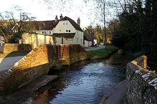
The River Meon is a chalk stream in Hampshire in the south of England. It rises at East Meon then flows 34 km (21 mi) in a generally southerly direction to empty into the Solent at Hill Head near Stubbington. Above Wickham, the river runs through the South Downs National Park.

Titchfield is a village and former civil parish in the Fareham district, in southern Hampshire, England, by the River Meon. The village has a history stretching back to the 6th century. During the medieval period, the village operated a small port and market. Near to the village are the ruins of Titchfield Abbey, a place with strong associations with Shakespeare, through his patron, the Earl of Southampton.

The Louth Navigation was a canalisation of the River Lud. It ran for 11 miles (18 km) from Louth in Lincolnshire, England, to Tetney Haven, at the mouth of the Humber. It was authorised by act of Parliament in 1763 and completed in 1770, under the supervision of the engineer John Grundy Jr. and then by James Hoggard. Eight locks were required to overcome the difference in altitude, six of which were constructed with sides consisting of four bays.
The Okeechobee Waterway or Okeechobee Canal is a relatively shallow artificial waterway in the United States, stretching across Florida from Fort Myers on the west coast to Stuart on Florida's east coast. The waterway can support tows such as barges or private vessels up to 50 feet wide x 250 feet long which draw less than 10 feet, as parts of the system, especially the locks may have low water depths of just ten feet. The system of channels runs through Lake Okeechobee and consists of the Caloosahatchee River to the west of the lake and the St. Lucie Canal east of the lake.
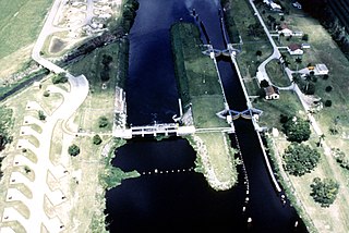
The Market Weighton Canal ran 9.5 miles (15.3 km) from the Humber Estuary to its terminus near Market Weighton. It gained its Act of Parliament in 1772 and opened in 1782. The 3.5 miles (5.6 km) closest to Market Weighton was abandoned in 1900 and the right of navigation through Weighton lock was lost in 1971. However, as of 2002 the lock was passable and the canal usable up to the junction with the River Foulness where silt has made it impassable. Also there is no right of navigation under the M62 motorway bridge to the north of Newport.

River engineering is a discipline of civil engineering which studies human intervention in the course, characteristics, or flow of a river with the intention of producing some defined benefit. People have intervened in the natural course and behaviour of rivers since before recorded history—to manage the water resources, to protect against flooding, or to make passage along or across rivers easier. Since the Yuan Dynasty and Ancient Roman times, rivers have been used as a source of hydropower. From the late 20th century, the practice of river engineering has responded to environmental concerns broader than immediate human benefit. Some river engineering projects have focused exclusively on the restoration or protection of natural characteristics and habitats.
Titchfield Carnival is an annual event that has been held in Titchfield, Hampshire, England, every year since 1880 onwards, except during World War I and World War II and 2007. It is organised each year by the Titchfield Bonfire Boys Society, and features a parade through the village, a funfair, a variety of floats, fireworks, and a bonfire. The carnival is also famous for its beauty Queen competition that attracts young girls from all across the town.
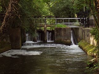
The Itchen Navigation is a 10.4-mile (16.7 km) disused canal system in Hampshire, England, that provided an important trading route from Winchester to the sea at Southampton for about 150 years. Improvements to the River Itchen were authorised by Act of Parliament in 1665, but progress was slow, and the navigation was not declared complete until 1710. It was known as a navigation because it was essentially an improved river, with the main river channel being used for some sections, and cuts with locks used to bypass the difficult sections. Its waters are fed from the River Itchen. It provided an important method of moving goods, particularly agricultural produce and coal, between the two cities and the intervening villages.

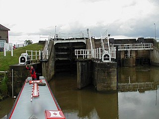
The River Don Navigation was the result of early efforts to make the River Don in South Yorkshire, England, navigable between Fishlake and Sheffield. The Dutch engineer Cornelius Vermuyden had re-routed the mouth of the river in 1626, to improve drainage, and the new works included provision for navigation, but the scheme did not solve the problem of flooding, and the Dutch River was cut in 1635 to link the new channel to Goole. The first Act of Parliament to improve navigation on the river was obtained in 1726, by a group of Cutlers based in Sheffield; the Corporation of Doncaster obtained an Act in the following year for improvements to the lower river. Locks and lock cuts were built and by 1751 the river was navigable to Tinsley.
Warnford is a village and civil parish in the City of Winchester district of Hampshire, England. The parish covers 1283 hectares. The village lies on the A32 in the upper valley of the River Meon between West Meon and Exton. The population in 2019 was estimated at 220. The village is rural in character, with most of the buildings along River Lane, Lippen Lane and Hayden Lane.
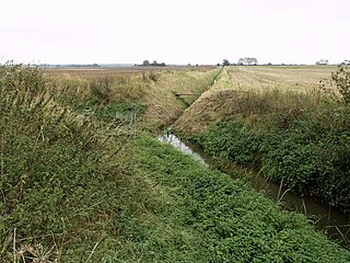
The River Foulness is a river in the East Riding of Yorkshire, England. Its name is derived from Old English fūle[n] ēa, meaning “dirty water”. Maintenance responsibilities for the river transferred from the Environment Agency to the Market Weighton Drainage Board on 1 October 2011. Market Weighton Drainage Board subsequently amalgamated with the Lower Ouse Internal Drainage Board on 1 April 2012 to create the Ouse and Humber Drainage Board. The river discharges into the Humber Estuary via Market Weighton Canal. Water levels within the river, its tributaries and the canal are managed and controlled by the Environment Agency. The river lies in an area known as the Humberhead Levels.
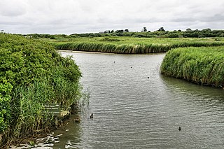
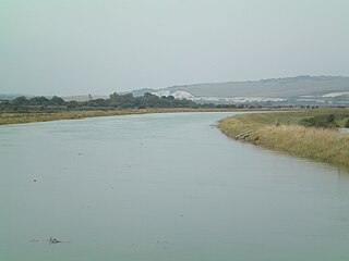
Titchfield Haven is a 134.5-hectare (332-acre) biological Site of Special Scientific Interest north-west of Gosport in Hampshire. Most of it is a local nature reserve and a national nature reserve. It is part of Solent and Southampton Water Ramsar site and Special Protection Area.

