Related Research Articles

The River Churn is a tributary of the River Thames in central England. It rises at Seven Springs in Gloucestershire and flows south for approximately 37.3 km (23.2 mi) to meet the Thames at Cricklade in Wiltshire. Its length from its source to the confluence with the Thames is greater than that of the Thames from Thames Head, though the Churn is regarded as a tributary rather than the main river.

The River Vyrnwy is a river which flows through northern Powys, Wales, and Shropshire, England. The name derives from Severn, the river of which it is a tributary.

The River Slea is a 36.4-kilometre-long (22.6 mi) tributary of the River Witham, in Lincolnshire, England. In 1872 the river was described as "a never-ending source of pure water", and was a trout river renowned throughout the East coast of England. But in the late 1960s, the Anglian Water Authority took control of the river, and thereafter it became rapidly degraded, due mostly to over-abstraction of water for use in farming.

The River Evenlode is a river in England which is a tributary of the Thames in Oxfordshire. It rises near Moreton-in-Marsh, Gloucestershire in the Cotswold Hills and flows south-east passing near Stow-on-the-Wold, Charlbury, Bladon, and Cassington, and its valley provides the route of the southern part of the Cotswold Line. The river flows for 45 miles (72 km) from source to the River Thames.

This River Blackwater drains small parts of the English counties of Hampshire and Wiltshire. It is a tributary of the River Test.

The River Dun is a tributary of the River Kennet, flowing through Wiltshire and Berkshire in England. Its main source is in the parish of Great Bedwyn, Wiltshire and it flows 16 kilometres (10 mi) in a northeasterly direction into Berkshire. It discharges into the Kennet at Hungerford, which has a smaller average flow and width upstream of that point.

Sleaford in Hampshire, England is a hamlet of Headley Civil Parish and the Northanger Ecclesiastical Benefice. It is in the civil parish of Whitehill
Colne Water is a river in eastern Lancashire. It is approximately 5.0 miles (7.987 km) long and has a catchment area excluding its major tributaries of 4.47 square miles (11.584 km2).

The Par River, also known as the Luxulyan River is a river draining the area north of St Blazey in Cornwall, in the United Kingdom.

The Swedish Environmental Protection Agency is a government agency in Sweden responsible for proposing and implementing environmental policies. It was founded in 1967 and reports to the Swedish Ministry of the Environment.
Main rivers are a statutory type of watercourse in England and Wales, usually larger streams and rivers, but also some smaller watercourses. A main river is designated by being marked as such on a main river map, and can include any structure or appliance for controlling or regulating the flow of water in, into or out of a main river. Every other open watercourse in England and Wales is determined by statute as an 'ordinary watercourse'.

The Sleaford Navigation was a 12.5 mile (20.1 km) canalisation of the River Slea in Lincolnshire, England, which opened in 1794. It ran from a junction with the River Witham, near Chapel Hill to the town of Sleaford through seven locks, most of which were adjacent to mills. Lack of finance meant that it stopped short of its intended terminus, but it gradually grew to be successful financially. The coming of the railways in 1857 led to a rapid decline, and it was officially abandoned by an act of Parliament in 1878, but remained open for a further three years. The lower part of it remained navigable until the 1940s, when it was blocked by a sluice.

The River Wey is a tributary of the River Thames in south east England. Its two branches, one of which rises near Alton in Hampshire and the other in West Sussex to the south of Haslemere, join at Tilford in Surrey. Once combined the flow is eastwards then northwards via Godalming and Guildford to meet the Thames at Weybridge. Downstream the river forms the backdrop to Newark Priory and Brooklands. The Wey and Godalming Navigations were built in the 17th and 18th centuries, to create a navigable route from Godalming to the Thames.

The River Leadon is a river in Herefordshire and Gloucestershire, England, a tributary of the River Severn. It rises just south of the village of Acton Beauchamp, and flows south past Bosbury to the town of Ledbury, which takes its name from the river. It then flows south and east past Dymock, Upleadon and Highleadon to join the Severn at Over, just west of Gloucester. The river is approximately 32 miles (51 km) long.
Slea Head is a promontory in the westernmost part of the Dingle Peninsula, located in the barony of Corca Dhuibhne in southwest County Kerry, Ireland. It belongs to the province of Munster and the county of Kerry and is served by the R559 road; the nearest villages are Ballyickeen and Coumeenoole. The headland itself, together with the larger part of Mount Eagle's southern slopes is formed from steeply dipping beds of the pebbly sandstones and conglomerates of the Slea Head Formation, dating from the Devonian period and traditionally referred to as the Old Red Sandstone.

The Gypsey Race is a winterbourne stream that rises to the east of Wharram-le-Street and flows through the villages of Duggleby, Kirby Grindalythe, West Lutton, East Lutton, Helperthorpe, Weaverthorpe, Butterwick, Foxholes, Wold Newton, Burton Fleming, Rudston and Boynton. The stream flows into the North Sea in Bridlington harbour. It is the most northerly of the Yorkshire chalk streams.

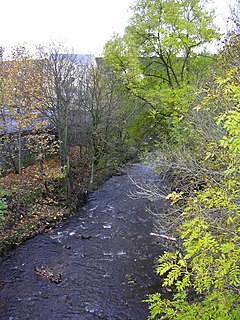
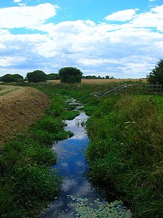
Oakhanger Stream is a tributary of the River Slea that lies in Hampshire, England.
The River Slea is a tributary of the south branch of the River Wey in Hampshire.
The Ferring Rife is a stream in West Sussex, England that rises in the West Durrington area of Worthing. It has multiple sources including one near Castle Goring and another in Titnore Wood. The streams converge that make up the Ferring Rife converge north of Littlehampton Road, passing through Maybridge, then west of Ferring into the sea. It flows south-west, west and then south into the English Channel, between the villages of Ferring and East Preston.

The R559 road is a regional road in Ireland which links various villages on Slea Head on the Dingle Peninsula with the town of Dingle and the N86 road.
References
- ↑ "Slea (Kingsley to Sleaford)". Environment Agency - Catchment Data Explorer. Retrieved 21 August 2020.
| Main rivers main tributaries & sub-tributaries |
|  | ||||||||||
|---|---|---|---|---|---|---|---|---|---|---|---|---|
| Canals and Navigations | ||||||||||||
| Ordinary watercourses | ||||||||||||
| Lakes, ponds and wetlands | ||||||||||||
| Coast | ||||||||||||
| | This Hampshire location article is a stub. You can help Wikipedia by expanding it. |