River Blackwater (River Test)

Last updated

Blackwater
River Blackwater east of Testwood Lake - geograph.org.uk - 344317.jpg
River Blackwater east of Testwood Lakes
Location
Country United Kingdom
Region Wiltshire, Hampshire
Physical characteristics
Source 
  location Redlynch, Wiltshire
  coordinates 50°59′23″N1°42′44″W / 50.98972°N 1.71222°W / 50.98972; -1.71222
Mouth Totton
  location
Hampshire
  coordinates
50°55′36″N1°29′31″W / 50.92667°N 1.49194°W / 50.92667; -1.49194 Coordinates: 50°55′36″N1°29′31″W / 50.92667°N 1.49194°W / 50.92667; -1.49194
Length45.0 km (28.0 mi)
Basin size67.5 km2 (26.1 sq mi)

This River Blackwater drains small parts of the English counties of Hampshire and Wiltshire. It is a tributary of the River Test.

Contents

Course

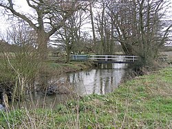
It rises just to the east of the Wiltshire village of Redlynch, east of Salisbury. It then flows east into Hampshire, where it flows north of the village of Wellow and the hamlet of Wigley. The river turns south, passing under the M27 and past Broadlands Lake and the Testwood Lakes reservoirs, before joining the Test between Totton and Redbridge. The Environment Agency records the length of the main river as 39.4 kilometres (24.5 mi), [1] with an additional 5.6 km (3.5 mi) [2] for the watercourse from Redlynch to the confluence north of Hamptworth.

Water quality

The Environment Agency measures water quality of the river systems in England. Each is given an overall ecological status, which may be one of five levels: high, good, moderate, poor and bad. There are several components that are used to determine this, including biological status, which looks at the quantity and varieties of invertebrates, angiosperms and fish. Chemical status, which compares the concentrations of various chemicals against known safe concentrations, is rated good or fail. [3]

Water quality of the River Blackwater in 2019:

SectionEcological
Status
Chemical
Status
Overall
Status
LengthCatchmentChannel
Blackwater [4] Moderate Fail Moderate 5.616 km (3.490 mi)12.068 km2 (4.659 sq mi)
Blackwater (Test and Itchen) [5] Good Fail Moderate 39.362 km (24.458 mi)67.526 km2 (26.072 sq mi)

See also

This River Blackwater should not be confused with the River Blackwater in north-east Hampshire, which is a tributary of the River Loddon and (indirectly) of the River Thames.

Another similarly named waterway in Hampshire is Black Water, a small stream which flows eastwards across the New Forest, passing under Rhinefield Ornamental Drive, before joining Ober Water and Highland Water just north of Brockenhurst to form the Lymington River.

Related Research Articles

<span class="mw-page-title-main">River Hamble</span> River in south Hampshire, England

The River Hamble is located in south Hampshire, England. It rises near Bishop's Waltham and flows for 10.1 km (6.3 mi) through Botley, Bursledon, and Lower Swanwick before entering Southampton Water between Hamble Common and Warsash.

<span class="mw-page-title-main">River Test</span> River in Hampshire, England

The River Test is a chalk stream in Hampshire in the south of England. It rises at Ashe near Basingstoke and flows southwards for 40 miles (64 km) to Southampton Water. Settlements on the Test include the towns of Stockbridge and Romsey. Below the village of Longparish, the river is broadly followed by the Test Way, a long-distance footpath.

<span class="mw-page-title-main">River Leam</span> River in Northamptonshire and Warwickshire, England

The River Leam, anciently Leame, etc, is a river in England which rises at Hellidon Hill in Northamptonshire then flows through Warwickshire, including the town of Leamington Spa, named after it. It then flows into the River Avon near Warwick, and thence into the River Severn. The name is first recorded in 956 as Limenan, and derives from British Lemanā, meaning "elm-tree river".

<span class="mw-page-title-main">River Churn</span> River in Gloucestershire and Wiltshire, England

The River Churn is a tributary of the River Thames in central England. It rises at Seven Springs in Gloucestershire and flows south for approximately 37.3 km (23.2 mi) to meet the Thames at Cricklade in Wiltshire. Its length from its source to the confluence with the Thames is greater than that of the Thames from Thames Head, though the Churn is regarded as a tributary rather than the main river.

<span class="mw-page-title-main">River Itchen, Hampshire</span> River in Hampshire, England

The River Itchen in Hampshire, England, rises to the south of New Alresford and flows 26 miles (42 km) to meet Southampton Water below the Itchen Bridge. The Itchen Navigation was constructed in the late 17th and early 18th centuries to enable barges to reach Winchester from Southampton Docks, but ceased to operate in the mid-19th century and is largely abandoned today.

<span class="mw-page-title-main">River Blackwater (River Loddon)</span> Tributary of the River Loddon in England

The River Blackwater is a tributary of the Loddon in England and sub-tributary of the Thames. It rises at two springs in Rowhill Nature Reserve between Aldershot, Hampshire and Farnham, Surrey. It curves a course north then west to join the Loddon in Swallowfield civil parish, central Berkshire. Part of the river splits Hampshire from Surrey; a smaller part does so as to Hampshire and Berkshire.

<span class="mw-page-title-main">River Pang</span> River in Berkshire, England

The River Pang is a small chalk stream river in the west of the English county of Berkshire, and a tributary of the River Thames. It runs for approximately 23 kilometres (14 mi) from its source near the village of Compton to its confluence with the Thames in the village of Pangbourne.

<span class="mw-page-title-main">River Meon</span> River in Hampshire, England

The River Meon is a chalk stream in Hampshire in the south of England. It rises at East Meon then flows 34 km (21 mi) in a generally southerly direction to empty into the Solent at Hill Head near Stubbington. Above Wickham, the river runs through the South Downs National Park.

<span class="mw-page-title-main">River Itchen, Warwickshire</span> River in east Warwickshire, England

The River Itchen flows through east Warwickshire in England. It is a small river, about 18 miles (29 km) long, and its general course is from south to north.

<span class="mw-page-title-main">River Wylye</span> River in Wiltshire, England

The River Wylye is a chalk stream in the south of England, with clear water flowing over gravel. It is popular with anglers for fly fishing. A half-mile stretch of the river and three lakes in Warminster are a local nature reserve.

<span class="mw-page-title-main">River Anton</span> River in Hampshire, England

The River Anton is a chalk stream in Hampshire in south east England. It rises in Andover and flows southwards for approximately 8 miles (13 km) to meet the River Test near Chilbolton. The principal tributary of the Anton, the Pillhill Brook, joins the river at Upper Clatford.

<span class="mw-page-title-main">River Dever</span> River in Hampshire, England

The River Dever is a chalk stream in Hampshire in the south of England. It rises at West Stratton near Micheldever and flows westwards for 11 mi (18 km) to meet the River Test at Wherwell.

<span class="mw-page-title-main">River Alre</span> River in Hampshire, England

The River Alre is a tributary of the River Itchen in Hampshire in the south of England. It rises in Bishop's Sutton and flows west for 6 km (3.7 mi) to meet the Itchen below New Alresford.

The River Nadder is a tributary of the River Avon, flowing in south Wiltshire, England.

<span class="mw-page-title-main">Cove Brook</span> River in Hampshire, England

Cove Brook runs 4 miles (6.4 km) from near Farnborough Airport in Farnborough, Hampshire, England and flows through the former Southwood Golf Course where it is joined by Marrow Brook and other smaller streams. It runs north through Cove before joining the Blackwater at Hawley Meadows near the M3 motorway.

<span class="mw-page-title-main">River Key</span> River in Wiltshire, England

The River Key is a tributary of the River Thames in England which flows through Wiltshire.

<span class="mw-page-title-main">River Wey</span> River in southern England

The River Wey is a main tributary of the River Thames in south east England. Its two branches, one of which rises near Alton in Hampshire and the other in West Sussex to the south of Haslemere, join at Tilford in Surrey. Once combined the flow is eastwards then northwards via Godalming and Guildford to meet the Thames at Weybridge. Downstream the river forms the backdrop to Newark Priory and Brooklands. The Wey and Godalming Navigations were built in the 17th and 18th centuries, to create a navigable route from Godalming to the Thames.

<span class="mw-page-title-main">River Till, Wiltshire</span> River in Wiltshire, England

The River Till rises near Tilshead on Salisbury Plain in the English county of Wiltshire. It flows for about 14 km south and south-east, through Orcheston, Maddington, Shrewton, Winterbourne Stoke, Berwick St James and Stapleford, to join the River Wylye.

<span class="mw-page-title-main">River Slea, Hampshire</span> River in Hampshire, England

The River Slea is a tributary of the south branch of the River Wey in Hampshire.

<span class="mw-page-title-main">Fleet Brook</span> River in northern Hampshire, England

Fleet Brook is a small river in northern Hampshire, England and tributary of the River Hart.

References

  1. "Blackwater (Test and Itchen)". Environment Agency - Catchment Data Explorer. Retrieved 23 December 2017.
  2. "Blackwater". Environment Agency - Catchment Data Explorer. Retrieved 23 December 2017.
  3. "Glossary (see Biological quality element; Chemical status; and Ecological status)". Catchment Data Explorer. Environment Agency. 17 February 2016. UKOpenGovernmentLicence.svg Text was copied from this source, which is available under an Open Government Licence v3.0. © Crown copyright.
  4. "Blackwater". Catchment Data Explorer. Environment Agency.
  5. "Blackwater (Test and Itchen)". Catchment Data Explorer. Environment Agency.