Fleet Pond

Last updated

Fleet Pond
Site of Special Scientific Interest
F07 Sunrise Dec VJ1.JPG
Location Hampshire
Grid reference SU 821 550 [1]
InterestBiological
Area48.3 hectares (119 acres) [1]
Notification 1984 [1]
Location map Magic Map

Fleet Pond is a 48.3-hectare (119-acre) biological Site of Special Scientific Interest in Fleet in Hampshire. [1] [2] It is also a Local Nature Reserve. [3] [4]

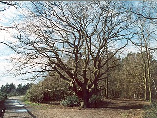
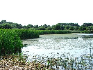
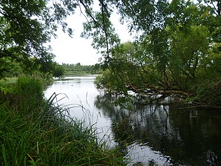
This large and shallow lake, fed by Fleet Brook, [5] is surrounded by reed beds, alder carr and oak and birch woodland. The lake has a rich aquatic flora and fauna, including large populations of reed warblers and other wetland birds. [6]

The pond has varied habitats surrounding it, including heathland, marsh, reedbed and woodland. [7] The pond is first documented in 1324, when there were two ponds which were used as a fishery. In medieval times, "pond" always referred to a man-made structure, whereas "lake" referred to a natural feature, and so it is likely that the ponds were created by raising banks at the northern edge. From 1491, the Prior of Winchester leased the ponds to the occupier of Fleet Farm, in exchange for one hundred fresh fish a year, delivered to Winchester. When the lease was renewed in 1833, it was noted that there was now only one pond. The second pond was probably near Ancells Farm. Shortly afterwards, the London and Southampton Railway bought the pond for £50 as it stood in the way of their line, and built an embankment across the northern end. They appreciated its potential as a tourist destination, and opened Fleet Pond Halt so that day trippers could visit it. Much of the surrounding area became a military training ground in 1854, and as part of that training, soldiers built a 470-yard (430 m) trestle bridge across it in 1885. During the Second World War, the pond was drained, to make the area less visible to enemy aircraft, but it was refilled in 1947, and planted with reeds. The pond became one of the first SSSIs in Hampshire in 1951, and under the Wildlife and Countryside Act 1981, duly re-registered, but to omit the portion north of the embankment. Hart District Council bought the pond and surrounding heath in 1972, after the army dubbed it redundant, and since 1976 has worked with the Fleet Pond Society to create a Local nature reserve. They have installed two bridges to create a circular walk around the pond. [8]

Related Research Articles

<span class="mw-page-title-main">River Blackwater (River Loddon)</span> Tributary of the River Loddon in England

The River Blackwater is a tributary of the Loddon in England and sub-tributary of the Thames. It rises at two springs in Rowhill Nature Reserve between Aldershot, Hampshire and Farnham, Surrey. It curves a course north then west to join the Loddon in Swallowfield civil parish, central Berkshire. Part of the river splits Hampshire from Surrey; a smaller part does so as to Hampshire and Berkshire.

<span class="mw-page-title-main">Cotswold Water Park</span>

The Cotswold Water Park is the United Kingdom's largest marl lake system, straddling the Wiltshire–Gloucestershire border, northwest of Cricklade and south of Cirencester. There are 180 lakes, spread over 42 square miles (110 km2).

<span class="mw-page-title-main">Norsey Wood</span> Woodland nature reserve in Billericay, Essex

Norsey Wood is a 67.2-hectare (166-acre) biological Site of Special Scientific Interest in Billericay, Essex. It is also a Local Nature Reserve and a Scheduled Monument.

<span class="mw-page-title-main">Thatcham Reed Beds</span> Nature reserve in the United Kingdom county of Berkshire

Thatcham Reed Beds is a 67.4-hectare (167-acre) biological Site of Special Scientific Interest east of Newbury in Berkshire. It is part of the Kennet & Lambourn Floodplain Special Area of Conservation and an area of 14 hectares is a Local Nature Reserve. An area of 35 hectares is managed by the Berkshire, Buckinghamshire and Oxfordshire Wildlife Trust.

<span class="mw-page-title-main">Sevenoaks Gravel Pits</span>

Sevenoaks Gravel Pits is a 73.7-hectare (182-acre) biological Site of Special Scientific Interest on the northern outskirts of Sevenoaks in Kent. It is managed by Kent Wildlife Trust as the Sevenoaks Wildlife Reserve and Jeffery Harrison Visitor Centre.

<span class="mw-page-title-main">Ingrebourne Marshes</span>

Ingrebourne Marshes are a 74.8 hectare biological Site of Special Scientific Interest in Hornchurch in the London Borough of Havering. Ingrebourne Valley Local Nature Reserve includes a small part of the SSSI west of the River Ingrebourne. The site is managed by the Essex Wildlife Trust

<span class="mw-page-title-main">Esher Commons</span> Several large wooded areas to the south-west of Esher

Esher Commons is a 360.1-hectare (890-acre) biological Site of Special Scientific Interest south-west of Esher in Surrey. It includes Esher Common, Fairmile Common, West End Common and Oxshott Heath. Esher Common and West End Common are Local Nature Reserves.

<span class="mw-page-title-main">Kempton Park Reservoirs</span>

Kempton Park Reservoirs are a Site of Special Scientific Interest in the London Borough of Hounslow and Kempton Park in Surrey. It is owned by Thames Water. It is part of South West London Waterbodies Ramsar site and Special Protection Area Kempton Park East reservoir is also a local nature reserve.

<span class="mw-page-title-main">Lye Valley</span>

Lye Valley is a 2.3-hectare (5.7-acre) biological Site of Special Scientific Interest in Headington, a suburb of Oxford in Oxfordshire. It is part of the 4.5-hectare (11-acre) Lye Valley Local Nature Reserve, which is owned and managed by Oxford City Council.

<span class="mw-page-title-main">Gosforth Nature Reserve</span>

Gosforth Nature Reserve is a wildlife haven in Tyne and Wear, England. It includes extensive woodland and wetland habitats and is managed by the Natural History Society of Northumbria. Access to the reserve is restricted to NHSN members and those in possession of a valid day pass. Dog walking and other recreational activities are not permitted on site. The reserve is part of Gosforth Park, the old estate of Gosforth House.

<span class="mw-page-title-main">Englemere Pond</span>

Englemere Pond is a 26.1-hectare (64-acre) biological Site of Special Scientific Interest on the southern outskirts of North Ascot in Berkshire. The site is also a Local Nature Reserve. It is owned by the Crown Estate and managed by Bracknell Forest Borough Council.

<span class="mw-page-title-main">Alresford Pond</span>

Alresford Pond is a 30.2-hectare (75-acre) biological Site of Special Scientific Interest in New Alresford in Hampshire.

<span class="mw-page-title-main">Broxhead and Kingsley Commons</span>

Broxhead and Kingsley Commons is a 105.1-hectare (260-acre) biological Site of Special Scientific Interest north of Lindford in Hampshire. It is part of Wealden Heaths Phase II Special Protection Area for the Conservation of Wild Birds and Broxhead Common is a 41.8-hectare (103-acre) Local Nature Reserve owned and managed by Hampshire County Council.

<span class="mw-page-title-main">Crab Wood</span>

Crab Wood is a 73-hectare (180-acre) biological Site of Special Scientific Interest west of Winchester in Hampshire. An area of 37.8 hectares is also a Local Nature Reserve.

<span class="mw-page-title-main">Shortheath Common</span>

Shortheath Common is a 59.5-hectare (147-acre) biological Site of Special Scientific Interest east of Bordon in Hampshire. It is also a Local Nature Reserve and a Special Area of Conservation.

<span class="mw-page-title-main">Wealden Edge Hangers</span>

Wealden Edge Hangers is a 222.4-hectare (550-acre) biological Site of Special Scientific Interest north of Petersfield in Hampshire. An area of 48 hectares is Wealden Edge Hangers Local Nature Reserve and an area of 144.1 hectares is Ashford Hangers National Nature Reserve. Wealden Edge Hangers is part of the East Hampshire Hangers Special Area of Conservation.

References

  1. 1 2 3 4 "Designated Sites View: Fleet Pond". Sites of Special Scientific Interest. Natural England. Retrieved 10 May 2020.
  2. "Map of Fleet Pond". Sites of Special Scientific Interest. Natural England. Retrieved 10 May 2020.
  3. "Fleet Pond". Local Nature Reserves. Natural England.
  4. "Map of Fleet Pond". Local Nature Reserves. Natural England.
  5. Ordnance Survey, 1:2500 map
  6. "Fleet Pond citation" (PDF). Sites of Special Scientific Interest. Natural England. Retrieved 10 May 2020.
  7. "Fleet Pond". Hart District Council. Archived from the original on 24 March 2016.
  8. Society (2016). "History". Fleet Pond Society. Archived from the original on 7 July 2016.

Coordinates: 51°17′18″N0°49′32″W / 51.28824°N 0.82550°W / 51.28824; -0.82550