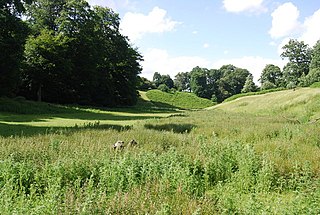
Knole Park is a 383.4-hectare (947-acre) biological Site of Special Scientific Interest in Sevenoaks in Kent. About 43 acres of the park belongs to the National Trust, as does Knole House, which sits within it. The remaining parkland is privately owned by the Knole Estate. It is in the Kent Downs Area of Outstanding Natural Beauty.

Whitehorse Hill is a hill in the Berkshire Downs in Oxfordshire, England, west of Wantage. At 261 metres (856 ft), it is the highest point in Oxfordshire. Uffington Castle lies on the summit of the hill, and the Uffington White Horse is on the hill's northern slope. The hill and an adjacent area below, including Dragon Hill and The Manger, make up a 98.9-hectare (244-acre) biological and geological Site of Special Scientific Interest.

River Avon System is a 475.9-hectare (1,176-acre) biological Site of Special Scientific Interest in Hampshire and Wiltshire, southern England. It is a Nature Conservation Review site, Grade I. It is part of the Avon Valley and New Forest Ramsar sites and is also part of two Special Protection Areas: Solent and Southampton Water, and the New Forest.

Kennet and Lambourn Floodplain is a 23.4-hectare (58-acre) biological Site of Special Scientific Interest in six widely separated areas in the floodplains of the River Lambourn in Berkshire and the River Kennet in Wiltshire, England. It is a Nature Conservation Review site and part of the Kennet and Lambourn Floodplain Special Area of Conservation. One of the areas, Rack Marsh, is managed by the Berkshire, Buckinghamshire and Oxfordshire Wildlife Trust.
Hatch Park is a 71.8-hectare (177-acre) biological Site of Special Scientific Interest east of Ashford in Kent. It is listed by Historic England on the Register of Historic Parks and Gardens of Special Historic Interest in England.

Staines Moor is a 510.8-hectare (1,262-acre) biological Site of Special Scientific Interest north of Staines-upon-Thames in Surrey. It is part of the South West London Waterbodies Ramsar site and a Special Protection Area

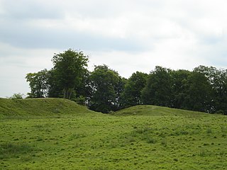
Totternhoe Knolls is a 13.1-hectare (32-acre) Site of Special Scientific Interest (SSSI) in Totternhoe in Bedfordshire. It is also a local nature reserve, and part of the Chilterns Area of Outstanding Natural Beauty. The site is owned by Central Bedfordshire Council and leased to the National Trust. Most of the site is maintained jointly by the National Trust and the Wildlife Trust for Bedfordshire, Cambridgeshire and Northamptonshire (WTBCN), and is part of the WTBCN Totternhoe nature reserve, which also includes Totternhoe Chalk Quarry and Totternhoe Stone Pit. The SSSI also includes Totternhoe Castle, the earthworks of a Norman motte-and-bailey castle which is a Scheduled monument.

Bradenham Woods, Park Wood and The Coppice is a 129.1-hectare (319-acre) biological Site of Special Scientific Interest in Bradenham in Buckinghamshire. It is in the Chilterns Area of Outstanding Natural Beauty, and it is described in A Nature Conservation Review. The site is part of the Bradenham Estate, which is owned by the National Trust. It is also designated a Special Area of Conservation. Grim's Ditch, a Scheduled Monument, runs through the site.

Rock Edge is a 1.7-hectare (4.2-acre) geological Site of Special Scientific Interest in Oxford in Oxfordshire. It is a Geological Conservation Review site and a Local Nature Reserve

Ashford Hill Woods and Meadows is a 141.5-hectare (350-acre) biological Site of Special Scientific Interest near Ashford Hill in Hampshire. An area of 23.45 hectares is Ashford Hill NNR, which is a National Nature Reserve.
Bramshill is a 673.3-hectare (1,664-acre) biological Site of Special Scientific Interest near Bramshill, northeast of Basingstoke in Hampshire. It is part of Thames Basin Heaths Special Protection Area for the conservation of wild birds.

Crab Wood is a 73-hectare (180-acre) biological Site of Special Scientific Interest west of Winchester in Hampshire. An area of 37.8 hectares is also a Local Nature Reserve.
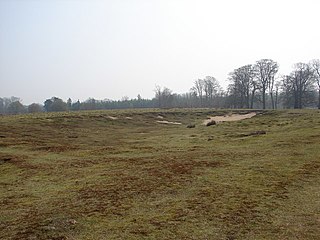
Danebury Hill is a 13.7-hectare (34-acre) biological Site of Special Scientific Interest north-east of Nether Wallop in Hampshire. It is part of Danebury Hillfort Local Nature Reserve.

East Aston Common is an 18.2-hectare (45-acre) biological Site of Special Scientific Interest east of Andover in Hampshire.

Hook Common and Bartley Heath is a 129.4-hectare (320-acre) biological Site of Special Scientific Interest on the southern outskirts of Hook in Hampshire, England. It is managed by the Hampshire and Isle of Wight Wildlife Trust.

Porton Down SSSI is a 1,559-hectare (3,850-acre) biological Site of Special Scientific Interest which spans the border between Hampshire and Wiltshire in England. It is adjacent to Porton Down science park near Porton, and much of it is Ministry of Defence property which is closed to the public. It is a Nature Conservation Review site, Grade I, a Special Area of Conservation and a Special Protection Area.

Upper Greensand Hangers: Empshott to Hawkley is a 37.7-hectare (93-acre) biological Site of Special Scientific Interest north of Petersfield in Hampshire. It is part of the East Hampshire Hangers Special Area of Conservation.

Wealden Edge Hangers is a 222.4-hectare (550-acre) biological Site of Special Scientific Interest north of Petersfield in Hampshire. An area of 48 hectares is Wealden Edge Hangers Local Nature Reserve and an area of 144.1 hectares is Ashford Hangers National Nature Reserve. Wealden Edge Hangers is part of the East Hampshire Hangers Special Area of Conservation.

Wick Wood and Worldham Hangers is a 91.8-hectare (227-acre) biological Site of Special Scientific Interest west of Bordon in Hampshire. It is part of the East Hampshire Hangers Special Area of Conservation.
