Ladle Hill

Last updated

Ladle Hill
Site of Special Scientific Interest
Ladle-Hill-geograph-306526-by-Andrew-Smith.jpg
Looking northeast towards Ladle Hill
Location Hampshire
Grid reference SU 477 568 [1]
InterestBiological
Area10.5 hectares (26 acres) [1]
Notification 1984 [1]
Location map Magic Map
Ladle Hill
Hampshire UK relief location map.jpg
Red triangle with thick white border.svg
Ladle Hill
Ladle Hill in Hampshire
Highest point
Elevation 232 m (761 ft)
Coordinates 51°18′31″N1°18′54″W / 51.3087°N 1.3149°W / 51.3087; -1.3149 Coordinates: 51°18′31″N1°18′54″W / 51.3087°N 1.3149°W / 51.3087; -1.3149
Geography
Location Hampshire, England
Topo map OS Landranger 174
Climbing
Easiest route Wayfarer's Walk

Ladle Hill is a 10.5-hectare (26-acre) biological Site of Special Scientific Interest west of Kingsclere in Hampshire. [1] [2] It is also a Scheduled Monument. [3]

Contents

Archaeology

Earthworks at Ladle Hill Fort earthworks, Ladle Hill - geograph.org.uk - 305517.jpg
Earthworks at Ladle Hill
3D view of the digital terrain model Ladle Hill Digital Terrain Model.jpg
3D view of the digital terrain model

The hillfort on the top of the hill has never been excavated, [4] [5] but the land and ditch are sharply defined and well preserved. This Iron Age fort is roughly rectangular and enclosed seven acres within an embankment and ditch. There are two probable entrances to the east and west. The work seems to have been undertaken by several different labour forces, each working on a section of the defences, but for some reason the task was abandoned and the fort left unfinished. A 170 ft diameter disc barrow lies just to the north (scheduled ancient monument number 43), [6] and there are several other barrows in the area, mostly ploughed-out. [7] [8]

The unfinished hillfort

Ladle Hill is perhaps the best known of all of the unfinished hillforts in Britain (Feacham 1971). It was first correctly identified as an unfinished hillfort and described in detail by the archaeologist Stuart Piggott in 1931. The site has been invaluable to help archeologists understand the methods employed in the creation of Iron Age date univallate enclosures, with the partially constructed nature of the site revealing features that would normally be concealed in a completed example, such as for possible setting-out ditches, and piles of chalky soil initially quarried from the ditch and deposited in the interior for finishing the rampart. [9]

At Ladle Hill it has long been suspected that the area demarcated by the unfinished earthworks never actually contained a settlement, although there is a possibility that the hillfort was to be constructed over an earlier unenclosed settlement. Magnetometer surveys from 1997 shows none of the variation normally associated with former occupation sites on chalk geology, and this would seem to confirm that a settlement with typical Iron Age characteristics, such as storage pits, was never established within the boundary of the earthwork. [9]

The earthworks were intended to enclose an area of approximately 3.5 ha (8.6 acres) and was marked by a slight ditch, or possibly an earlier palisaded enclosure. Apart from the dumps of material associated with the abandoned construction works, the interior has very few other earthworks of intelligible character. [9]

A dewpond on the hill with the hillfort earthworks in the background Dewpond and earthworks on Ladle Hill - geograph.org.uk - 361813.jpg
A dewpond on the hill with the hillfort earthworks in the background

Surrounding area

By contrast the surrounding areas contain a number of features of interest, including a linear ditch that runs along the crest of the west-facing escarpment of Great Litchfield Down and Ladle Hill, and is approximately 2,000 m (2,200 yd) in length. It ends at a slight spur overlooking the valley floor barrow cemetery of Seven Barrows. For a kilometer or so of its visible southern course, this earthwork also forms the western boundary of a large field system on Great Litchfield Down. This field system does not extend northwards as far as Ladle Hill. [9]

Immediately to the east of the unfinished hillfort is another linear ditch, not overlain by the hillfort, which is approximately 700 m (770 yd) in length, finishing at the head of a coombe below Hare Warren Down. To the east of this linear ditch is another large field system, visible both as areas of earthworks and as soil and crop marks on aerial photographs. [9]

To the southwest of Ladle Hill are two sub-square earthwork enclosures, each of approximately 0.3 ha (0.74 acres). Both are undated, but a possible link exists between such enclosures, linear ditches, and areas of probable grazing during the time of the late Bronze Age to early Iron Age transition (Cunliffe 1991, pg386). The features surrounding Ladle Hill are beyond the northern limit of the known field system on Great Litchfield Down and west of the fields on Hare Warren Down and Nuthanger Down. The unfinished hillfort therefore appears to be in an atypical Wessex location, being very close to major linear earthwork features, and in an area without an existing field system. [9]

Immediately to the north of Ladle Hill lies a well preserved disc barrow, some 170 ft (52 m) in diameter. Just beyond this there is evidence for traces of platforms that may represent the remains of an unenclosed settlement (Piggott 1931). This feature has never been surveyed in detail and although an open settlement is possible it may be that these are features of other disturbance such as localized surface quarrying. [9]

Within the northern half of the camp there are traces of a small, low mound, approximately 3 m (9.8 ft) in diameter, thought to be a disc barrow, but magnetometer surveys did not show any trace of a surrounding ditch. The mound today is hardly discernible, but early aerial photographs of the site (circa 1929) show that the mound was better preserved at the time of Piggott's original surveys in the first half of the 20th century. [9]

Roman features

Sited on the steep west slope of the hill is a Roman earthwork, formed by the erection of a substantial bank on the down hill side of the slope. It may have been a small circus or pond. [10]

Geology

The underlying geology at the site is Cretaceous Upper Chalk, supporting shallow well drained calcareous silty soils over chalk on slopes and crests. Typically these landscapes may be described as 'dramatic', due to their local scale, visual aesthetic and undulating nature. Escarpments are often formed where layers of chalk have been compressed to form a fold, or where the chalk has been faulted, resulting in accelerated erosion along the line of the weakness.

Many chalk grassland slopes in England show the mark of centuries of grazing by sheep, the slopes bearing a stepped or striped appearance formed by a mixture of soil creep and sheep paths. Such erosion is clearly visible on the slopes of Ladle Hill.

Ecology

Fairy flax, Liunum catharticum, can be found on Ladle Hill SSSI Liunum catharticum1.jpg
Fairy flax, Liunum catharticum, can be found on Ladle Hill SSSI

The flora and fauna on the hill have been recognised to be of particular importance, and is such that the hill was designated as a biological Site of Special Scientific Interest in 1978. Ladle Hill typifies a calcareous grassland chalk downland habitat now scarce in Britain, and is home to some unusual and rare species. The earthwork in particular is very rich in species, with a good range of downland grasses and large populations of rare and local plants such as field fleawort, Senecio integrifolius ; chalk milkwort, Polygala calcarea ; hairy rock-cress, Arabis hirsuta ; fragrant orchid, Gymnadenia conopsea ; and pyramidal orchid, Anacamptis pyramidalis . The earthwork escarpment slopes, though species-rich, support fewer species than within the fort, but some, notably clustered bellflower, Campanula glomerata , only occur there. [11]

The site is also importance for its population of the rare July flowering form of the burnt-tip orchid, Orchis ustulata . This form is morphologically distinct, has a peculiar flowering period, and survives now only on a few sites in Britain. [11]

The hill also supports salad burnet, thyme, fairy flax and hairy violet. There is some scattered scrub on the north-facing slope but there does not appear to be on-going encroachment. [12]

Location

The site is located at grid reference SU478568 , on Great Litchfield Down, to the southeast of the village of Old Burghclere, in the county of Hampshire. The hill has a summit of 232 m (761 ft) AOD just within the civil parish of Litchfield and Woodcott, with the hill also falling within the two other civil parishes of Burghclere, and Ecchinswell, Sydmonton and Bishops Green. Nearby to the west lies Beacon Hill and to the immediate east is Watership Down. Also to the north east lies Old Burghclere Lime Quarry SSSI. The A34 runs between the Ladle Hill and Beacon Hill to the east. The site and surrounding downs are easily accessible by public footpath, including the nearby cross county footpath, Wayfarer's Walk.

Related Research Articles

<span class="mw-page-title-main">Hillfort</span> Type of earthworks used as a fortified refuge or defended settlement

A hillfort is a type of earthwork used as a fortified refuge or defended settlement, located to exploit a rise in elevation for defensive advantage. They are typically European and of the Bronze Age or Iron Age. Some were used in the post-Roman period. The fortification usually follows the contours of a hill and consists of one or more lines of earthworks, with stockades or defensive walls, and external ditches. Hillforts developed in the Late Bronze and Early Iron Age, roughly the start of the first millennium BC, and were used in many Celtic areas of central and western Europe until the Roman conquest.

<span class="mw-page-title-main">Maiden Castle, Dorset</span> Iron Age hill fort in Dorset, England

Maiden Castle is an Iron Age hillfort 1.6 mi (2.6 km) southwest of Dorchester, in the English county of Dorset. Hill forts were fortified hill-top settlements constructed across Britain during the Iron Age.

<span class="mw-page-title-main">Danebury</span> Iron Age hillfort in Hampshire, England

Danebury is an Iron Age hill fort in Hampshire, England, about 19 kilometres (12 mi) north-west of Winchester. The site, covering 5 hectares, was excavated by Barry Cunliffe in the 1970s. Danebury is considered a type-site for hill forts, and was important in developing the understanding of hill forts, as very few others have been so intensively excavated.

<span class="mw-page-title-main">Beacon Hill, Burghclere, Hampshire</span>

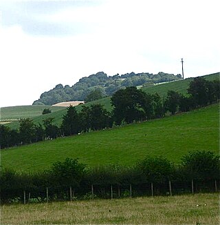
Beacon Hill is near the village of Burghclere and Watership Down, in north Hampshire. The hill's name is derived from the fact that it was one of many Beacon Hills in England and beyond. This hill was once the site of the most famous beacon in Hampshire. It is 261 metres high and has one of England's most well known hill forts on its slopes, visible from the main A34 road which passes close by. From there, outstanding views of the surrounding area and much of Hampshire may be obtained. The site is open to the public and managed by Hampshire County Council. It is an 80.7-hectare (199-acre) biological Site of Special Scientific Interest called Burghclere Beacon and a Nature Conservation Review site, Grade I.

<span class="mw-page-title-main">Beacon Hill, Warnford</span>

Beacon Hill, Warnford is a 46.4-hectare (115-acre) biological Site of Special Scientific Interest west of Warnford in Hampshire. It is a Nature Conservation Review site, and an area of 40.1 hectares is a national nature reserve. There is a round barrow cemetery dating to the Late Neolithic or Bronze Age on the hill, and this is a scheduled monument.

<span class="mw-page-title-main">Yarnbury Castle</span> Site of a multiphase, multivallate Iron Age hillfort in Wiltshire, England

Yarnbury Castle is the site of a multiphase, multivallate Iron Age hillfort near the village of Steeple Langford, Wiltshire, England. The site covers an area of 28.5 acres (11.5 ha), and was extensively surveyed and investigated by the Royal Commission on the Historical Monuments of England in 1991, with finds of Iron Age and Romano-British pottery, Iron Age and Roman coins, and burials of human remains. There is much evidence of prolonged and extensive settlement of the site, including evidence of around 130 structures of various sizes, most probably representing a mix of round houses, pits, and other features. It was designated as a scheduled monument in 1925.

<span class="mw-page-title-main">Plainsfield Camp</span> Iron Age earthwork in Somerset, England

Plainsfield Camp is a possible Iron Age earthwork on the Quantock Hills near Aisholt in Somerset, England.

<span class="mw-page-title-main">Ecchinswell</span> Human settlement in England

Ecchinswell is a village in the Basingstoke and Deane district of Hampshire, England.

<span class="mw-page-title-main">The Trundle</span> Archaeological site in West Sussex, England

The Trundle is an Iron Age hillfort on St Roche's Hill about 4 miles (6 km) north of Chichester, West Sussex, England, built on the site of a causewayed enclosure, a form of early Neolithic earthwork found in northwestern Europe. Causewayed enclosures were built in England from shortly before 3700 BC until at least 3500 BC; they are characterized by the full or partial enclosure of an area with ditches that are interrupted by gaps, or causeways. Their purpose is not known; they may have been settlements, meeting places, or ritual sites. Hillforts were built as early as 1000 BC, in the Late Bronze Age, and continued to be built through the Iron Age until shortly before the Roman occupation.

<span class="mw-page-title-main">Scratchbury Camp</span> Iron Age hillfort in Wiltshire, England

Scratchbury Camp is the site of an Iron Age univallate hillfort on Scratchbury Hill, overlooking the Wylye valley about 1 km northeast of the village of Norton Bavant in Wiltshire, England. The fort covers an area of 37 acres (15 ha) and occupies the summit of the hill on the edge of Salisbury Plain, with its four-sided shape largely following the natural contours of the hill.

<span class="mw-page-title-main">Chiselbury</span> Iron Age hillfort in Wiltshire, England

Chiselbury is the site of an Iron Age univallate hillfort located in Wiltshire. The hillfort is sub-circular in plan, and encloses an area of approximately 10.5 acres (460,000 sq ft). It is defined by an earthen rampart up to 3.6 metres (12 ft) in height and an external ditch, up to a maximum of 1.6 metres (5.2 ft) in depth. A gap in the southeastern side of the rampart, and a corresponding causeway across the ditch, is thought to be the original entrance and is associated with a small 'D' shaped embanked enclosure, which is apparently visible on aerial photographs. Although the enclosure has subsequently been degraded by ploughing, it is still apparent as a series of low earthworks.

<span class="mw-page-title-main">Sidbury Hill</span> Iron Age hillfort in Wiltshire, England

Sidbury Hill, or Sidbury Camp, is the site of an Iron Age bivallate hillfort on the eastern edge of Salisbury Plain in Wiltshire, England. The site is sub-triangular in shape, approximately 17 acres (6.9 ha) in area, and is constructed on the site of a Neolithic settlement.

<span class="mw-page-title-main">Bratton Castle</span> Iron Age hillfort in Wiltshire, England

Bratton Castle is a bivallate Iron Age built hill fort on Bratton Down, at the western edge of the Salisbury Plain escarpment. The hill fort comprises two circuits of ditch and bank which together enclose a pentagonal area of 9.3 hectares.

<span class="mw-page-title-main">Knook Castle</span> Iron Age hillfort in Wiltshire, England

Knook Castle is the site of an Iron Age univallate hillfort on Knook Down, near the village of Knook in Wiltshire, England, but within the civil parish of Upton Lovell. It has also been interpreted as a defensive cattle enclosure associated with nearby Romano-British settlements. It is roughly rectangular in plan with a single entrance on the south/southeast side, but with a later break in the wall on the western side.

<span class="mw-page-title-main">Ffridd Faldwyn, Montgomery</span>

Ffridd Faldwyn is an Iron Age hillfort in northern Powys, in the former county of Montgomeryshire, It is sited on a prominent hill west of Montgomery, close to but higher than Montgomery Castle, overlooking the River Severn. It is one of the largest hill-forts in Wales.

<span class="mw-page-title-main">Torberry Hill</span>

Torberry Hill is an Iron Age hillfort in the county of West Sussex, in southern England. It is a Scheduled Ancient Monument, with a list entry identification number of 1015966. The hill fort is located within the parish of Harting, within the South Downs National Park. The hill includes the remains of an Early Iron Age univallate hill fort, a Middle Iron Age promontory fort and a post-medieval post mill. The hill is a chalk spur projecting northwards from the South Downs.

Cecily Margaret Guido,, also known as Peggy Piggott, was an English archaeologist, prehistorian, and finds specialist. Her career in British archaeology spanned sixty years, and she is recognised for her field methods, her field-leading research into prehistoric settlements, burial traditions, and artefact studies, as well as her high-quality and rapid publication, contributing more than 50 articles and books to her field between the 1930s and 1990s.

<span class="mw-page-title-main">Beacon Hill, West Sussex</span>

Beacon Hill, also known as Harting Beacon, is a hillfort on the South Downs, in the county of West Sussex in southern England. The hillfort is located in the parish of Elsted and Treyford, in Chichester District. It is a Scheduled Ancient Monument with a list entry identification number of 1015915. The hilltop enclosure is dated to the Late Bronze Age, from the 8th to 6th centuries BC. The hillfort defences were renewed during the Late Iron Age.

<span class="mw-page-title-main">Martin Down Enclosure</span>

The Martin Down Enclosure is an archaeological site on Martin Down, near the village of Martin, in Hampshire, England. It is near the boundaries with Dorset and Wiltshire.

<span class="mw-page-title-main">Thundersbarrow Hill</span>

Thundersbarrow Hill is an archaeological site in West Sussex, England. It is on a chalk ridge, aligned north-west to south-east, on the South Downs north of Shoreham-by-Sea.

References

  1. 1 2 3 4 "Designated Sites View: Ladle Hill". Sites of Special Scientific Interest. Natural England. Retrieved 13 May 2020.
  2. "Map of Ladle Hill". Sites of Special Scientific Interest. Natural England. Retrieved 13 May 2020.
  3. Historic England. "An unfinished hillfort, a saucer barrow, a disc barrow and sections of two linear earthworks on Ladle Hill (1012038)". National Heritage List for England . Retrieved 23 April 2020.
  4. Williams-Freeman, 1915, 87-9, 380
  5. Piggott, 1931, Antiquity 5, 474-85
  6. "Hampshire Treasures website". Archived from the original on 5 June 2011. Retrieved 6 February 2011.
  7. "Ladle Hill". Archived from the original on 13 June 2010. Retrieved 26 September 2010. Roman Britain Organisation
  8. http://www.themodernantiquarian.com/site/4150/ladle_hill.html The Modern Antiquarian
  9. 1 2 3 4 5 6 7 8 "The wessex hillforts project: extensive survey of hillforts in central southern England", Andrew Payne, Mark Corney and Barry Cunliffe, published by English Heritage, 15/09/2006, ISBN   978-1-873592-85-4
  10. "Hampshire Treasures website". Archived from the original on 5 June 2011. Retrieved 6 February 2011.
  11. 1 2 http://www.english-nature.org.uk/citation/citation_photo/1001172.pdf English Nature SSSI Description
  12. "Natural England SSSI Assessment notes 05 Oct 2009" . Retrieved 6 February 2011.

Bibliography