
The Grianan of Aileach, sometimes anglicised as Greenan Ely or Greenan Fort, is a hillfort atop the 244 metres (801 ft) high Greenan Mountain at Inishowen in County Donegal, Ireland. The main structure is a stone ringfort, thought to have been built by the Northern Uí Néill, in the sixth or seventh century CE; although there is evidence that the site had been in use before the fort was built. It has been identified as the seat of the Kingdom of Ailech and one of the royal sites of Gaelic Ireland. The wall is about 4.5 metres (15 ft) thick and 5 metres (16 ft) high. Inside it has three terraces, which are linked by steps, and two long passages within it. Originally, there would have been buildings inside the ringfort. Just outside it are the remains of a well and a tumulus.

Tibbers Castle is a motte-and-bailey castle overlooking a ford across the River Nith in Dumfries and Galloway, Scotland. To the east is the village of Carronbridge and to the north west is a 16th-century country house, Drumlanrig Castle.

St Agnes is a civil parish and a large village on the north coast of Cornwall, UK. The village is about five miles (8 km) north of Redruth and ten miles (16 km) southwest of Newquay. An electoral ward exists stretching as far south as Blackwater. The population at the 2011 census was 7,565.
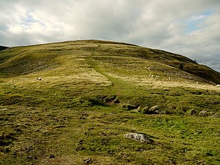
Humbleton Hill is a hill in Northumberland, England, about 1.5 miles (2.4 km) west of Wooler.

The Chalcolithic Temple of Ein Gedi is a Ghassulian public building dating from about 3500 BCE. It lies on a scarp above the oasis of Ein Gedi, on the western shore of the Dead Sea, within modern-day Israel. Archaeologist David Ussishkin has described the site as "a monumental edifice in terms of contemporary architecture".
Coxall Knoll is a hill lying on the boundary of Shropshire and Herefordshire, England; it is near Bucknell in Shropshire and Buckton and Coxall in Herefordshire. On the summit is an Iron Age hillfort, a scheduled monument.
The Pettigarths Field Cairns is a Neolithic site in the parish of Nesting, northeastern Whalsay, in the Shetland islands of Scotland. It is located approximately 140 metres (460 ft) to the northwest of Benie Hoose. The site contains upright stones as well as masonry. The south cairn is roughly 6 metres (20 ft) square, with an eastern entrance passage and circular chamber about 2 metres across. 4 metres (13 ft) to the north is a round cairn, 4.5 metres (15 ft) in diameter, with a rectangular cist. The two cairns are located on a rise, about 140 metres (460 ft) northwest of Benie Hoose.

Crosskirk Broch was a fortification near the present day hamlet of Crosskirk near Thurso, Caithness, Scotland. After thorough archaeological exploration it was destroyed in 1972 since the site had become unsafe due to sea erosion. The site was unusual in having a broch, a large circular fortification, built within an older promontory fortification with a ring wall and blockhouse.
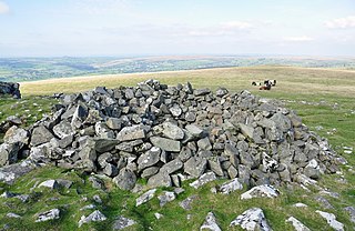
A tor cairn is a prehistoric cult site occurring in the British Isles, especially in Cornwall and Devon but also in Wales. It consists of a circular enclosure of stones or a platform of loose rocks surrounding a natural tor, sometimes encircled by a ditch. The diameter of the roughly 35 tor cairns ranges from 12 to over 30 metres and their height varies from 0.5 to 4.0 metres. There is usually an entrance to the enclosed area and pits in the ground between the rock outcrop (tor) itself and the enclosure.

Trevelgue Head, also known as Porth Island, is a headland north-east of Newquay, Cornwall, England, next to Porth at the eastern end of Newquay Bay.

Perran Round is an amphitheatre in the hamlet of Rose, midway between the villages of Goonhavern and Perranporth, Cornwall, UK. It is described as the best surviving example of a plen-an-gwary, a medieval amphitheatre used for performing the Ordinalia, or Cornish miracle plays.

Cadson Bury is an Iron Age hillfort about 2 miles (3.2 km) south-west of Callington, in Cornwall, England.
Bury Walls is an Iron Age hillfort about 1 mile (1.6 km) south-east of Weston-under-Redcastle, in Shropshire, England. It is a scheduled monument.

Lesingey Round is a ringfort, a smaller type of hillfort, about 1 mile (1.6 km) west of Penzance, in Cornwall, England. It is a scheduled monument.

Castle Goff is an enclosure about 1.5 miles (2.4 km) south-west of Camelford, in Cornwall, England. It is a scheduled monument.

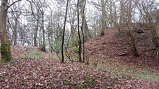
Hollingbury Castle, also known as Hollingbury Camp and Hollingbury Hillfort, is an Iron Age hillfort on the northern edge of Brighton, in East Sussex, England. It is adjacent to Hollingbury Park Golf Course.

Thundersbarrow Hill is an archaeological site in West Sussex, England. It is on a chalk ridge, aligned north-west to south-east, on the South Downs north of Shoreham-by-Sea.

Harrow Hill is an archaeological site in West Sussex, England. It is on the South Downs about 3 miles (5 km) north of the village of Angmering and 5 miles (8 km) north-west of Worthing.
Maiden Bower is an Iron Age hillfort near Dunstable in Bedfordshire, England. The site, which also has traces of a Neolithic causewayed enclosure, is a scheduled monument.
Huckhoe Settlement is an archaeological site in Northumberland, England, near the village of Bolam and about 7 miles (11 km) west of Morpeth. The site shows occupation, in at least four phases, dating from the early Iron Age to the post-Roman period. It is a scheduled monument.

