
Bodmin Moor is a granite moorland in north-eastern Cornwall, England, United Kingdom. It is 208 square kilometres (80 sq mi) in size, and dates from the Carboniferous period of geological history. It includes Brown Willy, the highest point in Cornwall, and Rough Tor, a slightly lower peak. Many of Cornwall's rivers have their sources here. It has been inhabited since at least the Neolithic era, when primitive farmers started clearing trees and farming the land. They left their megalithic monuments, hut circles and cairns, and the Bronze Age culture that followed left further cairns, and more stone circles and stone rows. By medieval and modern times, nearly all the forest was gone and livestock rearing predominated.
Lamorna is a village, valley and cove in west Cornwall, England, UK. It is on the Penwith peninsula approximately 4 miles (6 km) south of Penzance. Lamorna became popular with the artists of the Newlyn School, including Alfred Munnings, Laura Knight and Harold Knight, and is also known for former residents Derek and Jean Tangye who farmed land and wrote "The Minack Chronicles".

Coombe is a hamlet in northeast Cornwall, England, United Kingdom.

Trewarthenick is a hamlet in the civil parish of Tregoney in Cornwall, England, United Kingdom.

Porthcurno is a small village covering a small valley and beach on the south coast of Cornwall, England in the United Kingdom. It is the main settlement in a civil and an ecclesiastical parish, both named St Levan, which comprise Porthcurno, diminutive St Levan itself, Trethewey and Treen.

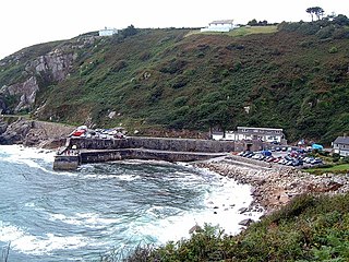
Treen is a small village in the parish of St Levan, in the far west of Cornwall, England, United Kingdom. It is about 3 miles (4.8 km) inland from Land's End on a short unclassified spur road from the B3315. Treen overlooks the Penberth Valley and sits about 1 kilometre (0.62 mi) inland from Treryn Dinas, an Iron Age promontory fort, or cliff castle, with five lines of fortification. On the headland is the Logan Rock and to the west is Pedn Vounder tidal beach, which is popular with naturists. Treen Cliff is to either side of Treryn Dinas. The village has a popular pub, The Logan Rock Inn, a village shop, cafe and campsite with views to both Logan Rock and nearby Porthcurno.
Paul is a village in Cornwall, England, United Kingdom. It is in the civil parish of Penzance. The village is two miles (3 km) south of Penzance and one mile (1.6 km) south of Newlyn.

Gunwalloe is a coastal civil parish in Cornwall, England, United Kingdom. It is situated on the Lizard Peninsula three miles (4.8 km) south of Helston and partly contains The Loe, the largest natural freshwater lake in Cornwall. The parish population including Berepper at the 2011 census was 219. The hamlets in the parish are Chyanvounder, Berepper and Chyvarloe. To the east are the Halzephron cliffs and further east the parish church.

Mullion is a civil parish and village on the Lizard Peninsula in south Cornwall, England, United Kingdom. The nearest town is Helston approximately 5 miles (8 km) to the north.

Ruan Lanihorne is a civil parish and village in south Cornwall, England, United Kingdom. The village is situated approximately four miles (6.5 km) east-southeast of Truro between the River Fal and its tributary the Ruan River.

St Anthony-in-Meneage is a coastal civil parish and village in Cornwall, England, United Kingdom. The parish is in the Meneage district of the Lizard peninsula. In the 2001 census the parish had a population of 171, decreasing to 168 at the 2011 census.

St Just in Roseland is a village and civil parish in Cornwall, England, United Kingdom. The village is 6 miles (10 km) south of Truro and 2 miles (3 km) north of St Mawes, a small village within the parish of St Just in Roseland. The 2011 Census recorded the parish population as 1,158.

New Mill is a small settlement in west Cornwall, England. It is approximately 2 miles (3.2 km) north of Penzance on the road to Gurnard's Head.

Gorran Haven is a fishing village, in the civil parish of St Goran, on the south coast of Cornwall, England, UK. It is about 2 miles (3.2 km) south of Mevagissey and lies within the Cornwall Area of Outstanding Natural Beauty (AONB).

St Loy's Cove is a small wooded valley and beach in the civil parish of St Buryan in Cornwall, England, UK. It is located two miles to the south of St Buryan churchtown, and between Penberth and Lamorna. There are just a few buildings in the cove, one of which, Cove Cottage, provides bed and breakfast and a cafe. St Loy's is within the Cornwall Area of Outstanding Natural Beauty (AONB), the Boscawen SSSI and is part of a GCR Geological Conservation Review site. The South West Coast Path passes through the cove.

Mabe is a village and civil parish in Cornwall, England, United Kingdom. The village is situated one mile (1.6 km) west of Penryn.

Carnmenellis Hill gives its name to the area of west Cornwall in England, between Redruth, Helston and Penryn. The hill itself is situated approximately three miles (5 km) south of Redruth. It is one of five Marilyns in Cornwall; the others being Brown Willy, Kit Hill, Hensbarrow Beacon and Watch Croft. The natural region of Carnmenellis has been designated as national character area 155 by Natural England.

St Gennys is a coastal civil parish and small settlement in north Cornwall, England, United Kingdom.

Lamorran is a village and former civil parish], now in the parish of St Michael Penkevil, in the Cornwall district, in the ceremonial county of Cornwall, England. Lamorran lies 3+1⁄2 miles (5.6 km) southeast of Truro, within the Cornwall Area of Outstanding Natural Beauty (AONB). In 1931 the parish had a population of 49.

Rinsey is a hamlet in Cornwall, England, United Kingdom. It is located off the main A394 road between Helston and Penzance in the civil parish of Breage. The nearby hamlet of Rinsey Croft is located 1 km to the north-east. The nearby cliffs and beach are owned and managed by the National Trust and part of Rinsey East Cliff is designated as the Porthcew Site of Special Scientific Interest (SSSI) for its geological interest. The South West Coast Path passes through the property. Rinsey lies within the Cornwall Area of Outstanding Natural Beauty (AONB).

