Carl Wark

Last updated

Carl Wark viewed from Higger Tor Carl Wark 20090912.jpg
Carl Wark viewed from Higger Tor

Carl Wark (sometimes Carl's Wark) is a rocky promontory on Hathersage Moor in the Peak District National Park, just inside the boundary of Sheffield, England. The promontory is faced by vertical cliffs on all but one side, which is protected by a prehistoric embankment. The cliffs and embankment form an enclosure that has been interpreted as an Iron Age hill fort, though the date of construction and purpose of the fortifications remains unknown. The site is a scheduled monument. [1]

Contents

Geography

Location

Carl Wark 061009.jpg
Hathersage Moor from the south showing Carl Wark overlooked by Higger Tor
Burbage Brook and Packhorse Bridge.jpg
Carl Wark viewed from Burbage Brook

Carl Wark is located at grid reference SK259814 , [1] at an elevation of about 370 metres (1,214 ft) above sea level. [2] [3] Hathersage is about 3 kilometres (1.86 mi) to the west; Sheffield City Centre about 11 kilometres (6.8 mi) to the north-east. [2] Historically this was within the ancient county of Derbyshire, but the surrounding area was annexed to the City of Sheffield in 1933, and now lies in the ceremonial county of South Yorkshire. [3]

The promontory is a Millstone Grit outcrop [4] situated in Hathersage Moor. From the north it is overlooked by the higher 434 metres (1,424 ft) peak of Higger Tor. [5] To the east is the valley of the Burbage Brook, which is overlooked by Burbage Rocks, a Millstone Grit escarpment. The land gently slopes away to the south following the course of Burbage Brook into the valley of the River Derwent. To the south-west, the land rises towards Winyards Nick and Over Owler Tor. [2]

Layout

1903 plan of Carl Wark Carl Wark plan Gould 1903.jpg
1903 plan of Carl Wark

The promontory is approximately 230 metres (750 ft) long and 60 metres (200 ft) wide, oriented south-east to north-west. [6] It gently slopes down to the west; at the peak of the promontory an area of 0.7 hectares (1.7 acres)180 metres (590 ft) long, 60 metres (200 ft) wide—is enclosed by natural cliffs enhanced with man-made fortifications. [7] The eastern and north-eastern sides of this enclosure are faced with vertical cliffs of up to 10 metres (33 ft) in height. The southern edge of the enclosure consists of large earth-fast boulders that have been reinforced with millstone grit blocks, forming a wall 2–2.5 metres (6.6–8.2 ft) high. A rampart across the western end of the promontory completes the enclosure. The rampart is 40 metres (130 ft) long and 8 metres (26 ft) wide at its base, rising to a height of 3 metres (9.8 ft). [8] It is constructed of a turf bank that is lined on its outer face with gritstone blocks. Within the southern wall, about 10 metres (33 ft) from the western rampart there is a 2-metre (6.6 ft) wide entrance. This entrance is a curved passage through the rock face with 2.5-metre (8.2 ft) walls on each side. [9]

At the south end of the rampart there are the remains of a shelter, possibly a shieling, built using stones from the rampart. [10] Around the base of the cliff at the eastern end of the promontory there is evidence of millstone production, probably dating from the 16th or 17th century. [11]

History

Outer stone face of the western rampart Carl Wark rampart face 20090912.jpg
Outer stone face of the western rampart

The date and purpose of the construction of the rampart at Carl Wark are uncertain. It has been described as being "unlike any other [structure] found in Northern England." [12] It is widely postulated to be a hill fort of Iron Age origin, perhaps dating from the 8th to the 5th centuries BC, [13] though a similar enclosure at Gardom's Edge has been dated to the late Bronze Age, between 1300 and 900 BC. [14] There is no evidence of settlement within the enclosure so it is unlikely that the site was used for a continuously occupied fort; it may have been used as a place of refuge for a population living in the surrounding area or it may have had some ceremonial purpose. [14]

Antiquarian Hayman Rooke, writing in 1785, gave one of the earliest descriptions of the structure. He thought that it was built by the British Celtic peoples, and surmised that "it is natural to imagine, from the many sacred erections, that this place must have been intended for holy uses, or a court of justice". [15] In 1861 historian John Gardner Wilkinson wrote that the site "bears the marked characteristics of an ancient British [Iron Age] fort", [16] whilst antiquarian and barrow-digger Thomas Bateman stated that he thought the encampment had been set up as a defence against Constantine the Great during the Roman rule of Britain. [17] Isaac Chalkley Gould also dismissed Rooke's idea that the enclosure had a sacred use, writing that it may have been used as a temporary fortified camp or refuge. [18] Following a limited excavation of the turf embankment by Frank Gerald Simpson in 1950, Cecily Margaret Piggott concluded that the rampart was constructed in the Early Middle Ages possibly in the 5th or 6th century as it is similar in construction techniques to some ramparts of this period in Scotland. [19] Some more recent historians agree with the view that the fortifications date from 'the Romano-British period at the start of the Dark Ages, maybe about 500 AD'. [20] Norman Price (1953) described Carl Wark as the site of a pre-Roman Celtic British encampment, later used for defence in the 6th century by Arthurian knight Sir Lamoracke, who he states was also known as Llywarch. [21] More recent assessments suggest that the site may have been in use since the Neolithic period, [14] perhaps with multiple uses and phases of construction. [22]

The origin of the name Carl Wark is uncertain. Rooke used the name "Cair's Work" in his 1785 description, whereas Bateman used "Carleswark". Sheffield historian and folklorist S. O. Addy, writing in 1893, posited that the name is Old Norse in origin, meaning 'The Old Man's Fort', where the 'Old Man' refers to the devil [23] —suggesting that the 9th to 10th century Danish settlers in the area regarded the enclosure as ancient and mysterious. [24] [25] The 1802 Derbyshire edition of The Beauties of England and Wales refers to a rock on the site named "Cair's Chair" [26] suggesting the Welsh word Caer meaning fort or rampart as a possible origin - Cair being an old spelling variant. [27]

A scene from the 1987 film The Princess Bride was filmed nearby at Carl Wark with Higger Tor visible in the background. [28]

See also

Related Research Articles

<span class="mw-page-title-main">Hathersage</span> Village in Derbyshire, England

Hathersage is a village and civil parish in the Peak District in Derbyshire, England. It lies slightly to the north of the River Derwent, approximately 10 miles (16.1 km) south-west of Sheffield.

<span class="mw-page-title-main">Stanage Edge</span> Escarpment in the Peak District, England

Stanage Edge, or simply Stanage is a gritstone escarpment in the Peak District, England, famous as a location for climbing. It lies a couple of miles to the north of Hathersage, and the northern part of the edge forms the border between the High Peak of Derbyshire and Sheffield in South Yorkshire. Its highest point is High Neb at 458 metres (1,503 ft) above sea level. Areas of Stanage were quarried in the past to produce grindstones, and some can still be seen on the hillside—carved, but never removed.

<span class="mw-page-title-main">Hope Valley, Derbyshire</span> Valley in Derbyshire, England

The Hope Valley is a rural area centred on the village of Hope, Derbyshire, in the Peak District in the northern Midlands of England.

<span class="mw-page-title-main">Wincobank (hill fort)</span>

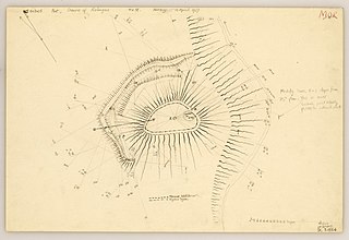
Wincobank is an Iron Age hill fort near Wincobank in Sheffield, England.

<span class="mw-page-title-main">Hathersage Road (Sheffield)</span> Road in South Yorkshire and Derbyshire, England

Hathersage Road is a road in Sheffield South Yorkshire, England and Derbyshire. It leads south-west from the suburb of Whirlow over the border between Hathersage and Sheffield, before becoming Sheffield Road at the point called Surprise View. The road begins at a bridge on the Limb Brook, the former boundary between Yorkshire and Derbyshire. There the road changes name from Ecclesall Road South to Hathersage Road.

<span class="mw-page-title-main">Higger Tor</span> Tor in England

Higger Tor or Higgar Tor is a gritstone tor in the Dark Peak, in the north of the Peak District National Park in England. It overlooks the Burbage Valley and the Iron Age hill fort of Carl Wark to the southeast.

<span class="mw-page-title-main">Burbage Brook</span> River in England

Burbage Brook is an upper tributary stream of the River Derwent in the Peak District of England.

<span class="mw-page-title-main">Berry Camp</span> Iron Age hill fort in Devon, England

<span class="mw-page-title-main">Embury Beacon</span>

Hillforts in Britain refers to the various hillforts within the island of Great Britain. Although the earliest such constructs fitting this description come from the Neolithic British Isles, with a few also dating to later Bronze Age Britain, British hillforts were primarily constructed during the British Iron Age. Some of these were apparently abandoned in the southern areas that were a part of Roman Britain, although at the same time, those areas of northern Britain that remained free from Roman occupation saw an increase in their construction. Some hillforts were reused in the Early Middle Ages, and in some rarer cases, into the Later Medieval period as well. By the early modern period, these had essentially all been abandoned, with many being excavated by archaeologists in the nineteenth century onward.

<span class="mw-page-title-main">Giant's Castle, Isles of Scilly</span> Iron Age promontory fort on the Isles of Scilly, England

The Giant's Castle is a promontory fort of the Iron Age, on St Mary's, Isles of Scilly, England. It is a scheduled monument.

<span class="mw-page-title-main">Promontory forts of Cornwall</span> Cliff castles in north-west Europe

Cornish promontory forts, commonly known in Cornwall as cliff castles, are coastal equivalents of the hill forts and Cornish "rounds" found on Cornish hilltops and slopes. Similar coastal forts are found on the north–west European seaboard, in Normandy, Brittany and around the coastlines of the British Isles, especially in Wales, Scotland and Ireland. Many are known in southwest England, particularly in Cornwall and its neighbouring county, Devon. Two have been identified immediately west of Cornwall, in the Isles of Scilly.

<span class="mw-page-title-main">Crosskirk Broch</span>

Crosskirk Broch was a fortification near the present day hamlet of Crosskirk near Thurso, Caithness, Scotland. After thorough archaeological exploration it was destroyed in 1972 since the site had become unsafe due to sea erosion. The site was unusual in having a broch, a large circular fortification, built within an older promontory fortification with a ring wall and blockhouse.

<span class="mw-page-title-main">Torberry Hill</span>

Torberry Hill is an Iron Age hillfort in the county of West Sussex, in southern England. It is a Scheduled Ancient Monument, with a list entry identification number of 1015966. The hill fort is located within the parish of Harting, within the South Downs National Park. The hill includes the remains of an Early Iron Age univallate hill fort, a Middle Iron Age promontory fort and a post-medieval post mill. The hill is a chalk spur projecting northwards from the South Downs.

<span class="mw-page-title-main">Doune of Relugas</span>

The Doune of Relugas is a hill fort located 9.25 kilometres (5.75 mi) south south west of Forres in Moray, Scotland. It is situated on a rocky knoll rising to approximately 400 feet (120 m) above ordnance datum and forming the south east part of the promontory at the confluence of the River Findhorn and the River Divie. The site commands an uninterrupted view of the valley of the Findhorn as far as Culbin Sands, 9 miles to the north on the shore of the Moray Firth.

<span class="mw-page-title-main">The Bulwarks, Porthkerry</span>

The Bulwarks, Porthkerry is a promontory fort in Rhoose, Vale of Glamorgan, on the southern coast of Wales overlooking the Bristol Channel. It probably dates to the Iron Age and continued to be occupied during the Roman period in Britain. The ramparts and ditches along the west side are well preserved, but the fortifications are heavily overgrown.

<span class="mw-page-title-main">Trevelgue Head</span> Headland in Cornwall

Trevelgue Head, also known as Porth Island, is a headland north-east of Newquay, Cornwall, England, next to Porth at the eastern end of Newquay Bay.

<span class="mw-page-title-main">Bury Walls</span> Iron Age hillfort in Shropshire, England

Bury Walls is an Iron Age hillfort about 1 mile (1.6 km) south-east of Weston-under-Redcastle, in Shropshire, England. It is a scheduled monument.

<span class="mw-page-title-main">Burbage Rocks</span> Hill in the English Peak District

Burbage Rocks is a gritstone escarpment in South Yorkshire, overlooking the village of Hathersage in the Peak District. The highest point along the escarpment is 429 metres (1,407 ft) above sea level, whilst Burbage Moor rises above to 438 metres (1,437 ft). Burbage Rocks is a southern extension of Stanage Edge. Burbage Brook runs from the northern end of the Burbage Rocks, past the southern end, through Padley Gorge and into the RIver Derwent.

References

Footnotes
  1. 1 2 Historic England. "Carl Wark (312285)". Research records (formerly PastScape). Retrieved 28 November 2018.
  2. 1 2 3 "Grid reference SK 259 814". Get A Map. Ordnance Survey. Archived from the original on 27 July 2015. Retrieved 9 April 2011.
  3. 1 2 Savage 1999 , p. 11
  4. Gould 1903 , p. 179
  5. "Grid reference SK 257 819". Get A Map. Ordnance Survey. Archived from the original on 27 July 2015. Retrieved 9 April 2011.
  6. Bevan 2006 , p. 30
  7. Addy 1893 , p. 11
  8. Bevan 2006 , p. 31
  9. Wilkinson 1861 , pp. 163–164
  10. Bevan 2006 , p. 36
  11. Bevan 2006 , pp. 41–42
  12. Savage 1999 , p. v
  13. Bevan, B. (2007). Sheffield's Golden Frame: the moorland heritage of Burbage, Houndkirk and Longshaw. Stockport: Sigma. p. 32. Archived from the original on 2 April 2012. Retrieved 18 September 2011.
  14. 1 2 3 Bevan, B. (2007). Sheffield's Golden Frame: the moorland heritage of Burbage, Houndkirk and Longshaw. Stockport: Sigma. p. 35. Archived from the original on 2 April 2012. Retrieved 18 September 2011.
  15. Rooke, Hayman (1785). "A Further Account of Some Druidical Remains in Derbyshire". Archaeologia. VII: 175–177. Retrieved 12 February 2011.
  16. Wilkinson 1861 , p. 163
  17. Bateman, Thomas (1861). Ten Years' Diggings in Celtic and Saxon Grave Hills, in the Counties of Derby, Stafford, and York, from 1848 to 1858. London: George Allen & Sons. p.  253. OCLC   66308476 . Retrieved 12 February 2011.
  18. Gould 1903 , pp. 178–179
  19. Piggott, Cecily Margaret (1951). "Notes and News". Antiquity. 25 (100): 210–212. doi:10.1017/S0003598X00020548. S2CID   246046288.
  20. "Carl Wark". Peak District Information. Archived from the original on 20 April 2021. Retrieved 24 May 2022.
  21. Price, Norman (1953). The Derbyshire Dales. London: Frederick Warne & Co. Ltd. pp. 27–28.
  22. Savage 1999 , pp. 46–48
  23. Addy 1893 , pp. 16–17
  24. Armitage 1905 , p. 41
  25. Gould 1903 , p. 175
  26. Britton & Brayley 1802 , pp. 477–478
  27. A Dictionary of the Welsh Language. University of Wales. 2018.
  28. "'The Princess Bride': 10 INCONCEIVABLE facts from the Academy's live-commentary screening". Entertainment Weekly. Archived from the original on 1 September 2014. Retrieved 4 October 2013.
Sources

53°19′46″N1°36′46″W / 53.32944°N 1.61278°W / 53.32944; -1.61278