
Hod Hill is a large hill fort in the Blackmore Vale, 3 miles (5 km) north-west of Blandford Forum, Dorset, England. The fort sits on a 143 m (469 ft) chalk hill of the same name that lies between the adjacent Dorset Downs and Cranborne Chase. The hill fort at Hambledon Hill is just to the north. The name probably comes from Old English "hod", meaning a shelter, though "hod" could also mean "hood", referring to the shape of the hill.

Weaver Vale is a constituency in Cheshire represented in the House of Commons of the UK Parliament since 2017 by Mike Amesbury, a member of the Labour Party.
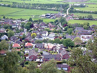
Helsby is a village, civil parish and electoral ward in the unitary authority of Cheshire West and Chester and the ceremonial county of Cheshire, England. Overlooking the Mersey estuary, it is approximately 9 miles (14 km) north east of Chester and 2.5 miles (4 km) south west of Frodsham.

Helsby railway station serves the village of Helsby in Cheshire, England. It is recorded in the National Heritage List for England as a Grade II listed building.
Castle Hill is a scheduled ancient monument in Almondbury overlooking Huddersfield in the Metropolitan Borough of Kirklees, West Yorkshire, England. The hilltop has been settled for at least 4,000 years. The scheduled monument comprises the remains of a late-Bronze Age or early Iron Age univallate hillfort with a single raised bank, a later Iron Age multivallate hillfort, a 12th-century motte-and-bailey castle, and the site of a deserted medieval village. The grade II listed Victoria Tower on the summit of Castle Hill is by far the most conspicuous landmark in Huddersfield. The hill has been a place of recreation for hundreds of years and the easily discernible remains of past occupation have made it a subject for legend, speculation and scientific study. It is located on UK Maps at grid reference SE152140.

Poundbury Hill is the site of a scheduled Prehistoric and Roman archaeological remains and includes evidence of a Neolithic settlement, a substantial Bronze Age occupation site and an Iron Age hillfort. There are also late Iron Age burials and a section of Roman aqueduct. On the eastern side is an earlier Romano-British farmstead; and an extensive later cemetery, belonging to the Roman town Durnovaria.

Bickerton Hill refers to two low red sandstone hills that form the southern end of the Mid Cheshire Ridge in Cheshire, north-west England. The high point, Raw Head, lies on the northerly hill and has an elevation of 227 metres. Parts of the southerly hill are also known as Larkton Hill.
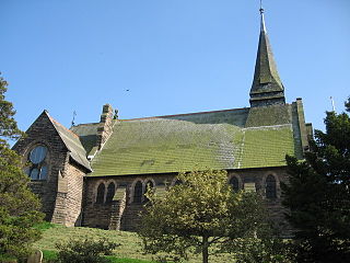
St Paul's Church is in the village of Helsby, Cheshire, England. The church is recorded in the National Heritage List for England as a designated Grade II listed building, and is an active Anglican parish church in the diocese of Chester, the archdeaconry of Chester and the deanery of Frodsham. Its benefice is combined with that of St Luke, Dunham-on-the-Hill.

Maiden Castle is an Iron Age hill fort, one of many fortified hill-top settlements constructed across Britain during the Iron Age, but one of only seven in the county of Cheshire in northern England. The hill fort was probably occupied from its construction in 600 BC until the Roman conquest of Britain in the 1st century AD. At this time the Cornovii tribe are recorded to have occupied parts of the surrounding area but, because they left no distinctive pottery or metalworking, their occupation has not been verified. Since then it has been quarried and used for military exercises. It is protected as a Scheduled Ancient Monument, and is owned by the National Trust. The hill fort is open to visitors, but unrestricted access to the site has resulted in it being classified as "at high risk" from erosion.

Kelsborrow Castle is an Iron Age hill fort in Cheshire, northern England. Hill forts were fortified hill-top settlements constructed across Britain during the Iron Age. It is one of only seven hill forts in the county of Cheshire and was probably in use for only a short time. In the 19th century, a bronze palstave was recovered from the site. It is protected as a Scheduled Ancient Monument.
Bradley hill fort is an Iron Age hill fort. Hill forts were fortified hill-tops, used as settlements or temporary refuges, constructed across Britain during the Iron Age. It is the smallest of the seven hill forts in the county of Cheshire in northern England. It is protected as a Scheduled Ancient Monument.
Eddisbury hill fort, also known as Castle Ditch, is an Iron Age hill fort near Delamere, Cheshire, in northern England. Hill forts are fortified hill-top settlements constructed across Britain during the Iron Age. Eddisbury is the largest and most complex of the seven hill forts in the county of Cheshire. It was constructed before 200–100 BC and expanded in 1–50 AD. In the 1st century AD, the Romans slighted the site. It was reoccupied in the 6th–8th centuries AD, and an Anglo-Saxon burh was probably established at Eddisbury in 914. In the medieval and post-medieval periods quarrying and farming have damaged the site. Ownership is currently split between the Forestry Commission and a local farm. Eddisbury is protected as a Scheduled Ancient Monument.
Oakmere hill fort is an Iron Age hill fort, one of many large fortified settlements constructed across Britain during the Iron Age, but one of only seven in the county of Cheshire in northern England. It is protected as a Scheduled Ancient Monument. Despite being a low-lying site, Oakmere is still considered a hill fort.

The Mid Cheshire Ridge is a range of low sandstone hills which stretch north to south through Cheshire in North West England. The ridge is discontinuous, with the hills forming two main blocks, north and south of the "Beeston Gap". The main mass of those to the south are known as the Peckforton Hills; the larger group of hills to the north do not have a collective name.

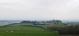
Woodhouse hill fort is an Iron Age hillfort between Frodsham and Helsby in Cheshire, England. It lies at the northern end of the Mid Cheshire Ridge. Woodhouse Hill has steep cliffs on the western sides, providing a natural defence. It is defended by a rampart to the north and east where the ground slopes more gently. Excavations in 1951 showed that the rampart was originally 4m high and revetted with stone on both sides. A number of small rounded stones, believed to be slingstones, have been found on the site. The hill fort is protected as a Scheduled Ancient Monument.

Cornish promontory forts, commonly known in Cornwall as cliff castles, are coastal equivalents of the hill forts and Cornish "rounds" found on Cornish hilltops and slopes. Similar coastal forts are found on the north–west European seaboard, in Normandy, Brittany and around the coastlines of the British Isles, especially in Wales, Scotland and Ireland. Many are known in southwest England, particularly in Cornwall and its neighbouring county, Devon. Two have been identified immediately west of Cornwall, in the Isles of Scilly.

Grangelands and Pulpit Hill is a 25.5-hectare (63-acre) biological Site of Special Scientific Interest in Cadsden in Buckinghamshire. It lies within the Chilterns Area of Outstanding Natural Beauty, and the planning authorities are Wycombe District Council and Buckinghamshire County Council.

Combs Moss is a plateau-topped hill between Chapel-en-le-Frith and Buxton in Derbyshire, in the Peak District. The summit, Combs Head, is 503 metres (1,650 ft) above sea level.

