Danebury is an Iron Age hillfort in Hampshire, England, about 19 kilometres (12 mi) north-west of Winchester. The site, covering 5 hectares, was excavated by Barry Cunliffe in the 1970s. Danebury is considered a type-site for hill forts, and was important in developing the understanding of hillforts, as very few others have been so intensively excavated.
Woodgreen is a village and civil parish within the New Forest district of Hampshire in England.
Burghfield is a village and large civil parish in West Berkshire, England, with a boundary with Reading. Burghfield can trace its history back to before the Domesday Book, and was once home to three manors: Burghfield Regis, Burghfield Abbas, and Sheffield. Since the 1980s the population of Burghfield has nearly doubled with the construction of housing estates, making it a dormitory for Reading, Newbury, Basingstoke and the M4 corridor.
Whitsbury is a village and civil parish in Hampshire, England, close to Fordingbridge. Whitsbury is a part of a group of villages on the edge of the Cranborne Chase and West Wiltshire Downs Area of Outstanding Natural Beauty.

Worlebury Hill is the name given to an upland area lying between the flatlands of Weston-super-Mare and the Kewstoke area of North Somerset, England. Worlebury Hill's rises from sea level to its highest point of 109 metres (358 ft), and the western end of the hill forms a peninsula, jutting out into the Bristol Channel, between Weston Bay and Sand Bay. A toll road follows the coast around the hill from Sand Bay in the north to the now derelict Birnbeck Pier in the west, although tolls are not currently collected on the road. Worlebury Golf Club is situated on the Hill and the area is known for being one of the wealthiest areas in the county of Somerset.
George Heywood Maunoir Sumner (1853–1940) was originally an English painter, illustrator, and craftsman, closely involved with the Arts and Crafts movement and the late-Victorian London art world. In his mid-forties he relocated to Cuckoo Hill, near Fordingbridge in Hampshire, England, and spent the rest of his life investigating and recording the archaeology, geology and folklore of the New Forest and Cranborne Chase regions.

Ibsley is a village and former civil parish, now in the parish of Ellingham, Harbridge and Ibsley, in the New Forest district, in Hampshire, England. It is about 2.5 miles (4 km) north of the town of Ringwood. In 1931 the parish had a population of 228.
Vespasian's Camp is an Iron Age hillfort just west of the town of Amesbury, Wiltshire, England. The hillfort is less than 3 kilometres (2 mi) from the Neolithic and Bronze Age site of Stonehenge, and was built on a hill next to the Stonehenge Avenue; it has the River Avon on its southern side and the A303 road on its northern edge. The site is a scheduled monument and lies within the boundaries of the Stonehenge World Heritage Site.

Buckland Rings is the site of an Iron Age hill fort in the town of Lymington, Hampshire. Today, the mounds and dykes around the outside which once constituted its defences are still clearly visible, although the outer bank lies under the road on the west side, and on the south-east it is nearly ploughed-out. Excavations of the inner and middle ramparts in 1935 revealed that they were of wall-and-fill construction, retained at the front by upright timber beams and walls of cut and laid turf. The entrance, which lies on the east side, was also excavated revealing a long entrance passage and the postholes for a pair of stout gateposts. The site was bought by Hampshire County Council in 1989 to ensure its preservation, and it is open to the public from the A337 road onto which part of it faces.

Ladle Hill is a 10.5-hectare (26-acre) biological Site of Special Scientific Interest west of Kingsclere in Hampshire. It is also a Scheduled Monument.
Ashley's Copse is the site of an Iron Age hillfort, about 8 miles (13 km) northeast of the city of Salisbury, England, straddling the border between the counties of Wiltshire and Hampshire. The site is a scheduled monument.

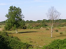
Castle Hill is the site of an Iron Age univallate hillfort located in the civil parish of Burley in the New Forest national park in Hampshire, England. Its single rampart and ditch earthworks enclose approximately five acres of land and is in reasonable condition for the most part, although it is cut through by tracks leading to local houses. Parts of the interior are marshy and much of it is overgrown with oak, silver birch, holly and bracken. The bank is at its highest on the eastern side, as the west side slopes steeply away. Hampshire treasures lists the site as a Scheduled Ancient Monument. According to legend, the hill apparently was once the home to a local dragon, duly slain by a knight from the nearby village of Brook; and thus the local pub at Brook bears the name of the Green Dragon.
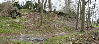
Chilworth Ring is the site of a small univallate Iron Age hillfort located in Hampshire. Partial excavations of the site were carried out in 1928. The site has now been developed into circle of detached houses lying within the ramparts, constructed sometime in the 1960s. The original bank can only be seen in the Eastern quadrant where it is followed by the road. The nearby Castle Hill earthwork to the west is thought to have been a cattle enclosure. The road serving the houses is called The Ring.
Frankenbury Camp is the site of an Iron Age univallate hillfort located in Hampshire. The site is on a very slight promontory overlooking the Avon Valley on the north-western edge of the New Forest. The fort encloses approximately 11 acres. It has very steep natural slopes on the west and south sides. The northeast sides are defended by a simple rampart and ditch. The original entrance on the southeast corner has since been widened. It is listed as a scheduled ancient monument no.122. The site is currently pasture, and part of Folds Farm, for the most part, although the earthworks themselves are lined with trees and the south and western parts are now encroached by woodland. Various archaeological relics have been found in the area:
Lockerley Camp is the site of an Iron Age univallate hillfort located in Hampshire. Situated on a low gravel-capped plateau, it covers approximately 5 acres and is now much reduced by ploughing, for the majority of the site falls into farmland, although a small area to the north is within a small coppice and the earthworks are more discernible here.

Norsebury Ring is the site of an Iron Age univallate hillfort located in Hampshire. Now mostly ploughed out to the South and east, some ditches and ramparts remain within a small copsed area to the North and west, which are surprisingly intact with a small outer ditch, then a bank, then another larger ditch followed by larger bank. However the trees and undergrowth hide the earthworks from immediate view.

Tidbury Ring is the site of an Iron Age univallate hillfort located in Hampshire. The earthworks have been heavily destroyed by ploughing, but some sections to the south remain in better condition. The entrance lies to the southeast of the fort. The interior is for the most part farmland with the earthworks now covered by small trees and undergrowth Two Roman buildings, possibly a courtyard villa complex were found within the hill-fort. The site is now listed as a scheduled ancient monument no.87

Furze Hill is a hamlet situated in the New Forest National Park of Hampshire, England. It is in the civil parish of Ellingham, Harbridge and Ibsley. Its nearest town is Fordingbridge, which lies approximately 3.1 miles (5.2 km) north-west from the hamlet.

South Gorley is a hamlet in the New Forest National Park of Hampshire, England. It is in the civil parish of Ellingham, Harbridge and Ibsley. Its nearest town is Ringwood, which lies approximately 3 miles (4.8 km) south-west of the hamlet.
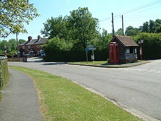
North Gorley is a hamlet in the New Forest National Park of Hampshire, England. Its nearest town is Fordingbridge, which lies approximately 2 miles (3.2 km) north of the hamlet.