City of Sheffield

Last updated

Sheffield
Sheffield City.jpg
Clockwise from top left: The Sheffield Town Hall; St Paul's Tower from Arundel Gate; the Wheel of Sheffield; Park Hill flats; Meadowhall shopping centre; Sheffield station and Sheaf Square
Coat of arms of Sheffield City Council.png
Nickname: 
‘Steel City’
Motto(s): 
’Deo Adjuvante Labor Proficit’
(Latin: ’With God's help our labour is successful’)
Sheffield UK locator map.svg
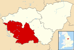
Sheffield shown within South Yorkshire
England relief location map.jpg
Red pog.svg
Sheffield
Location within England
United Kingdom relief location map.jpg
Red pog.svg
Sheffield
Location within the United Kingdom
Europe relief laea location map.jpg
Red pog.svg
Sheffield
Location in Europe
Coordinates: 53°23′N1°28′W / 53.383°N 1.467°W / 53.383; -1.467 Coordinates: 53°23′N1°28′W / 53.383°N 1.467°W / 53.383; -1.467
Sovereign state United Kingdom
Country England
Region Yorkshire and the Humber
Ceremonial county South Yorkshire
Historic county Yorkshire
Urban core and outlying areas
Derbyshire
Some southern suburbs
Foundedc.8th century
Town charter10 August 1297
City status1893
Administrative HQ Sheffield Town Hall
Government
  Type Metropolitan borough and city
  Governing body Sheffield City Council
   Lord Mayor Sioned-Mair Richards (Labour)
   Executive Labour (council NOC)
  Council LeaderTerry Fox (Labour)
Area
  City142.06 sq mi (367.9 km2)
  Rank 108th
Population
 (2021)
  City556,521 (Ranked 4th)
  Density3,920/sq mi (1,513/km2)
  Ethnicity
Demonym Sheffielder
Time zone UTC+0 (Greenwich Mean Time)
  Summer (DST) UTC+1 (British Summer Time)
Postcode
S
Area code 0114
Police South Yorkshire
Fire and Rescue South Yorkshire
Ambulance Yorkshire
Motorways
International airports Doncaster/Sheffield (DSA)
GDP US$ 38.8 billion
– Per capita US$ 26,157
Councillors84
MPs
Website www.sheffield.gov.uk

The City of Sheffield is a city and metropolitan borough in South Yorkshire, England. The metropolitan borough includes the administrative centre of Sheffield, the town of Stocksbridge and larger village of Chapeltown and part of the Peak District. [2] It has a population of 584,853 (mid-2019 est), making it technically the third largest city in England by population behind Birmingham and Leeds, since London is not considered a single entity. It is governed by Sheffield City Council.

Contents

The current city boundaries were set on 1 April 1974 by the provisions of the Local Government Act 1972, as part a reform of local government in England. The city is a merger of two former local government districts; the unitary City and County Borough of Sheffield combined with the urban district of Stocksbridge and parts of the rural district of Wortley from the West Riding of Yorkshire. [3]

For its first 12 years the city had a two-tier system of local government; Sheffield City Council shared power with South Yorkshire County Council. Since the Local Government Act 1985 Sheffield City Council has effectively been a unitary authority, serving as the sole executive, deliberative and legislative body responsible for local policy, setting council tax, and allocating budget in the city, and is a member of the Sheffield City Region Partnership. The City of Sheffield is divided into three civil parishes and a single unparished area.

Geography

Rivelin Valley Rivelin Valley - geograph.org.uk - 171316.jpg
Rivelin Valley
Gleadless Valley, demonstrating the hilly terrain within the city Gleadless Valley view.jpg
Gleadless Valley, demonstrating the hilly terrain within the city

The present city boundaries were set in 1974 (with slight modification in 1994), when the former county borough of Sheffield merged with Stocksbridge Urban District and two parishes from the Wortley Rural District. [4] This area includes a significant part of the countryside surrounding the main urban region. Roughly a third of Sheffield lies in the Peak District National Park. No other English city had parts of a national park within its boundary, [5] until the creation in March 2010 of the South Downs National Park, part of which lies within Brighton and Hove.

Governance

Sheffield City Council is the local authority of the district. The council is composed of 84 councillors, three for each of the city's 28 wards. It is currently under No Overall Control. The City was under Labour control from its creation until 1999, when the Liberal Democrats took control of the council. The Labour Party regained control of the Council in 2002 with power shifting back to the Liberal Democrats in 2008. However, Labour took control once again in 2011. Following the 2021 elections the Council is now in No Overall Control. As a metropolitan county, South Yorkshire does not have a county council, so Sheffield City Council is the primary provider of local government services. The district forms part of the Yorkshire and the Humber region of England.

Most of the district is an unparished area, comprising Sheffield itself (the area of the former county borough). In the unparished area there is no lower tier of government. Outside the unparished area there are 3 civil parishes, represented by parish councils. These form the lowest tier of local government. The 3 civil parishes are: [6]

The district is represented by five MPs, for the constituencies of Sheffield Brightside and Hillsborough, Sheffield Central, Sheffield Hallam, Sheffield Heeley, Sheffield South East all currently represented by Labour. The constituency of Penistone and Stocksbridge is partially in the City of Sheffield and is represented by the Conservatives.

Demography

The latest (2021) population estimate for the City of Sheffield is 556,521 residents. [7]

Transport

Parts of the city are covered by the Sheffield Supertram light rail tram network.

Notes and references

References

  1. "Elected representatives". sheffield.gov.uk. Retrieved 26 June 2020.
  2. Van den Berg 2006 , p. 179.
  3. "Local Government Act 1972". legislation.gov.uk . Retrieved 1 July 2022.
  4. "City Profile Introduction". Sheffield City Council. 31 January 2013. Archived from the original on 19 October 2014. Retrieved 13 October 2013.
  5. "New village officer will boost rural communities". Peak District National Park Authority. 22 June 2009. Archived from the original on 20 July 2011. Retrieved 7 August 2009.
  6. "Yorkshire and the Humber Local Authority districts and parishes". CityPopulation.de. Retrieved 15 May 2021.
  7. "Sheffield Resident Population Estimates by Ethnic Group and Sex, All Persons". National Statistics: Neighbourhood Statistics. Retrieved 25 October 2009.

Bibliography

Related Research Articles

<span class="mw-page-title-main">Metropolitan county</span> Type of county-level administrative division of England

Metropolitan counties are a type of county-level administrative division of England. There are six metropolitan counties, which each cover large urban areas, with populations between 1 and 3 million. They were created in 1974 and are each divided into several metropolitan districts or boroughs. Following the abolition of metropolitan county councils in 1986, metropolitan counties no longer form a part of local government in England. Most of their functions were devolved to the metropolitan boroughs, making the boroughs effectively unitary authorities; any remaining functions were taken over by joint boards.

<span class="mw-page-title-main">South Yorkshire</span> County in England

South Yorkshire is a ceremonial and metropolitan county in the Yorkshire and Humber Region of England. The county has four council areas which are the cities of Doncaster and Sheffield as well as the boroughs of Barnsley and Rotherham.

<span class="mw-page-title-main">North Yorkshire</span> County of England

North Yorkshire is a ceremonial county in the North of England. It is mostly located in the Yorkshire and Humber region, but the area around the Tees Valley is in the North East. The largest county in England by land area, it measures 2,483 square miles (6,430 km2) and has a population of 1,158,816 (2021). The county town is Northallerton.

<span class="mw-page-title-main">Subdivisions of England</span> Administrative division or non-administrative ceremonial area of England

The subdivisions of England constitute a hierarchy of administrative divisions and non-administrative ceremonial areas.

<span class="mw-page-title-main">Counties of England</span> Englands administrative, geographical and political demarcation

The counties of England are areas used for different purposes, which include administrative, geographical, cultural and political demarcation. The term "county" is defined in several ways and can apply to similar or the same areas used by each of these demarcation structures. These different types of county each have a more formal name but are commonly referred to as just "counties". The current arrangement is the result of incremental reform.

<span class="mw-page-title-main">County borough</span> Borough or city independent of county council control

County borough is a term introduced in 1889 in the United Kingdom of Great Britain and Ireland, to refer to a borough or a city independent of county council control, similar to the unitary authorities created since the 1990s. An equivalent term used in Scotland was a county of city. They were abolished by the Local Government Act 1972 in England and Wales, but continue in use for lieutenancy and shrievalty in Northern Ireland. In the Republic of Ireland they remain in existence but have been renamed cities under the provisions of the Local Government Act 2001. The Local Government (Wales) Act 1994 re-introduced the term for certain "principal areas" in Wales. Scotland did not have county boroughs but instead had counties of cities. These were abolished on 16 May 1975. All four Scottish cities of the time—Aberdeen, Dundee, Edinburgh, and Glasgow—were included in this category. There was an additional category of large burgh in the Scottish system, which were responsible for all services apart from police, education and fire.

<span class="mw-page-title-main">Metropolitan Borough of Barnsley</span> Metropolitan borough in England

The Metropolitan Borough of Barnsley is a metropolitan borough in South Yorkshire, England; the main settlement is Barnsley and other notable towns include Penistone, Wombwell and Hoyland.

<span class="mw-page-title-main">Civil parish</span> Territorial designation and lowest tier of local government in England

In England, a civil parish is a type of administrative parish used for local government. It is a territorial designation which is the lowest tier of local government. Civil parishes can trace their origin to the ancient system of ecclesiastical parishes, which historically played a role in both secular and religious administration. Civil and religious parishes were formally differentiated in the 19th century and are now entirely separate. Civil parishes in their modern form came into being through the Local Government Act 1894, which established elected parish councils to take on the secular functions of the parish vestry.

<span class="mw-page-title-main">Redcliffe-Maud Report</span> 1969 proposed English local government reorganisation

The Redcliffe-Maud Report was published in 1969 by the Royal Commission on Local Government in England, under the chairmanship of Lord Redcliffe-Maud. Although the commission's proposals were broadly accepted by the Labour government, they were set aside by the Conservative government elected in 1970.

<span class="mw-page-title-main">Local Government Act 1972</span> United Kingdom legislation

The Local Government Act 1972 is an Act of the Parliament of the United Kingdom that reformed local government in England and Wales on 1 April 1974. It was one of the most significant Acts of Parliament to be passed by the Heath Government of 1970–74.

<span class="mw-page-title-main">Penistone and Stocksbridge (UK Parliament constituency)</span> Parliamentary constituency in the United Kingdom

Penistone and Stocksbridge is a constituency in the House of Commons of the UK Parliament represented since 2019 by Miriam Cates, a Conservative. As with all constituencies, adults qualifying to vote in the seat elect one Member of Parliament (MP) by the first past the post system of election at least every five years.

<span class="mw-page-title-main">Metropolitan and non-metropolitan counties of England</span> Subdivisions of England

Metropolitan and non-metropolitan counties are one of the four levels of subdivisions of England used for the purposes of local government outside Greater London and the Isles of Scilly. As originally constituted, the metropolitan and non-metropolitan counties each consisted of multiple districts, had a county council and were also the counties for the purposes of Lieutenancies. Later changes in legislation during the 1980s and 1990s have resulted in counties with no county council and 'unitary authority' counties with no districts. Counties for the purposes of Lieutenancies are now defined separately, based on the metropolitan and non-metropolitan counties.

<span class="mw-page-title-main">County Borough of Leeds</span> Administrative division of Yorkshire, England until 1974

The County Borough of Leeds, and its predecessor, the Municipal Borough of Leeds, was a local government district in the West Riding of Yorkshire, England, from 1835 to 1974. Its origin was the ancient borough of Leeds, which was reformed by the Municipal Corporations Act 1835. In 1889, when West Riding County Council was formed, Leeds became a county borough outside the administrative county of the West Riding; and in 1893 the borough gained city status. The borough was extended a number of times, expanding from 21,593 acres (8,738 ha) in 1911 to 40,612 acres (16,435 ha) in 1961; adding in stages the former area of Roundhay, Seacroft, Shadwell and Middleton parishes and gaining other parts of adjacent districts. In 1971 Leeds was the fifth largest county borough by population in England. The county borough was abolished in 1974 and replaced with the larger City of Leeds, a metropolitan district of West Yorkshire.

<span class="mw-page-title-main">Unitary authorities of England</span> Local government in some parts of England

The unitary authorities of England are those local authorities which are responsible for the provision of all local government services within a district. They are constituted under the Local Government Act 1992, which amended the Local Government Act 1972 to allow the existence of counties that do not have multiple districts. They typically allow large towns to have separate local authorities from the less urbanised parts of their counties and originally provided a single authority for small counties where division into districts would be impractical. However, the UK government has more recently proposed the formation of much larger unitary authorities, including a single authority for North Yorkshire, the largest non-metropolitan county in England, at present divided into seven districts.

<span class="mw-page-title-main">Local Government Commission for England (1992)</span>

The Local Government Commission for England was the body responsible for reviewing the structure of local government in England from 1992 to 2002. It was established under the Local Government Act 1992, replacing the Local Government Boundary Commission for England. The Commission could be ordered by the Secretary of State to undertake "structural reviews" in specified areas and recommend the creation of unitary authorities in the two-tier shire counties of England. The Commission, chaired by John Banham, conducted a review of all the non-metropolitan counties of England from 1993 to 1994, making various recommendations on their future.

<span class="mw-page-title-main">History of local government in England</span> Aspect of history

The history of local government in England is one of gradual change and evolution since the Middle Ages. England has never possessed a formal written constitution, with the result that modern administration is based on precedent, and is derived from administrative powers granted to older systems, such as that of the shires.

The history of local government in Yorkshire is unique and complex. Yorkshire is the largest historic English county and consists of a diverse mix of urban and rural development with a heritage in agriculture, manufacturing, and mining. After a long period with little change, it has been subject to a number of reforms of local government structures in modern times, some of which were controversial. The most significant of these were the Local Government Act 1972, the 1990s UK local government reform, and the Localism Act 2011. The historic area currently corresponds to several counties and districts and is mostly contained within the Yorkshire and the Humber region.

<span class="mw-page-title-main">Shropshire Council</span> British administrative body

Shropshire Council is the local authority of Shropshire, in England, comprising the ceremonial county of Shropshire except Telford and Wrekin. It is a unitary authority, having the powers of a non-metropolitan county and district council combined.

<span class="mw-page-title-main">City of Leeds</span> City in West Yorkshire, England

The City of Leeds is a city and metropolitan borough in West Yorkshire, England. The metropolitan borough includes the administrative centre of Leeds and the towns of Farsley, Garforth, Guiseley, Horsforth, Morley, Otley, Pudsey, Rothwell, Wetherby and Yeadon. It has a population of 811,956 (2021), making it technically the second largest city in England by population behind Birmingham, since London is not a single local government entity. Local governance sits with Leeds City Council and the city's 32 Parish Councils.

<span class="mw-page-title-main">City of York Council</span> Council for the city of York, England

City of York Council is the municipal governing body of the City of York, a unitary authority in Yorkshire, England. It is composed of 47 councillors, one, two, or three for each of the 21 electoral wards of York. It is responsible for all local government services in the City of York, except for services provided by York's town and parish councils.