Dungworth

Last updated

Dungworth
Green Fold Farmhouse, Dungworth.JPG
Green Fold Farmhouse
South Yorkshire UK location map.svg
Red pog.svg
Dungworth
Location within South Yorkshire
Civil parish
  • Bradfield
Metropolitan borough
Metropolitan county
Region
Country England
Sovereign state United Kingdom
Post town SHEFFIELD
Postcode district S6
Dialling code 0114
Police South Yorkshire
Fire South Yorkshire
Ambulance Yorkshire
UK Parliament
List of places
UK
England
Yorkshire
53°24′29″N1°34′37″W / 53.408°N 1.577°W / 53.408; -1.577

Dungworth (archaic Dungeworth, [1] ) is a hamlet in the civil parish of Bradfield, west of Sheffield in South Yorkshire, England.

Contents

The village also gives its name as a surname; a 'Dungworth' is recorded living at the nearby village of Storrs in 1323. In the late 20th century the English occurrences of the surname remained concentrated in the Sheffield area. [2]

Modern geography and economy

Dungworth is a hamlet located approximately 1.25 miles (2 km) west of Stannington and the outermost suburbs of Sheffield in agricultural high ground at around 200 m (660 ft) above sea level. It is 500 yards (0.5 km) south of the eastern end of Damflask reservoir. [3] The village has a primary school Bradfield Dungworth School, [4] and a public house, the Royal Hotel. [5]

Social geography

The village pub has long been a centre of village life, games of Knurr and Spell were played in the 1920s and there were clubs for fishing, running, football and cricket. [6] At Christmas time people have sung local songs in the pub for over 200 years, although this tradition is under threat with the possible closure of the pub in 2024. [7] [8] [9]

The village has a school "Bradfield Dungworth School" and a community hall. [10]

History

A medieval cross, Dungworth Cross was once located northwest of the village. [11] [12] (grid reference SK 2780 9036 )

Dungworth has a long tradition of dairy farming, and at one time there were eight dairy farms in the area, each delivering their own milk to the surrounding district, but this has been significantly reduced in recent years.[ when? ][ citation needed ] A cruck barn at Briers House farm once used as a cowhouse and hayloft dates from the 16th century. [13]

Manufacture of knives took place in Dungworth in the 17th and 18th centuries; [14] the nearby 'Sykehouse' (c. 1800) at Syke House farm has hearths and workshop dating from the period. [15] The census of 1861 shows a large number of men in the Dungworth, Hill Top and Storrs area who combined farming with the production of knives in small workshops attached to their cottages. [10] Coal was mined near Dungworth up to the 19th century; it was found in association with ganister. [16]

There are several historic buildings within the village dating from the 18th century; Green Fold farm dates from the early 18th century, [17] and Padley farmhouse (converted to three cottages, formerly 'Dungworth Hall'. [10] ), dates from the mid 18th century. [18]

The village pub dates to 1813, [5] parts of the village primary school date from the 1840s. [4] A Primitive Methodist chapel was built in the village around 1850; [19] the anniversary of the church's founding in June of each year was a highlight of village social life in the early and mid 20th century. [10]

Ringwood House on Main Road was once a butcher's shop and had arched cellars used for storing meat,[ when? ] it continued as a grocery shop until the 1970s, known as "Harper's Shop". [10]

Some additional housing was built around the village in the mid 20th century: on the road to Dungworth cross (1920/30s), [20] and later (1956) several council houses were built on Dungworth Green (road). [21] [22] In 1985 the local school amalgamated with Low Bradfield Junior and Infants' School to form the present Bradfield Dungworth School on Dungworth Green. Dungworth Green Community Hall, adjoining the school was opened in 2011. [10]

Two professional footballers are associated with Dungworth: Cec Coldwell (b. 1929) was born in here, while Tony Hawksworth (b. 1938) grew up here.

Load Brook

53°23′40″N1°35′32″W / 53.39433°N 1.59235°W / 53.39433; -1.59235 (Load Brook)

Load Brook seen from the east, the coniferous plantation in the background is the site of the old mine Load Brook 1.JPG
Load Brook seen from the east, the coniferous plantation in the background is the site of the old mine

The hamlet of Load Brook is located about 1.25 miles (2 km) roughly southwest of Dungworth at around 295 m (968 ft) above sea level. [23]

Load Brook was developed from a farm to a minor industrial site in the late 19th and early 20th centuries. [24] [25] A "pot clay" mine (pot clay – a type of fireclay from the Stannington pot clay bed) was developed to the southwest in the 1850s by William Trickett, a local farmer. [26] Trickett obtained rights to mine pot clay from the landowner, the Duke of Norfolk in 1852 and was mentioned in the Sheffield Trade Directory of 1862 as a clay merchant. William Trickett died in 1890 and the business was continued by his three sons, William, Benjamin and Matthew under the name of B. Trickett & Co.[ citation needed ]

The mine was officially named the Intake Clay Pit and had four drift entrances going into the hillside; one of these is still visible as is the path of the former tramway which had stone foundations. Ponies were used to pull the wagons from the mine along the tramway to the brick works, which had two rock crushers and three coal fired brick kilns. Cottages were built at the site to house the workers. [26] Facilities included a works ~100 SW of the hamlet and a track and tramway northward from the works, at around the 300 to 350 m (980 to 1,150 ft) mark. [25]

The mine was later taken over[ when? ] by Thomas Wragg & Sons who had a business in the Loxley valley making refractory bricks; the mine and works closed in the 1950s. [26] In the second half of the 20th century the site and surrounding land was gradually used for forestry. [27] As of 2010 the former industrial use was marked by field boundaries, and remains of the trackways. [28]

Present day

Load Brook Cottages, are former miners cottages that have been converted into holiday accommodation Load Brook Cottages.JPG
Load Brook Cottages, are former miners cottages that have been converted into holiday accommodation

Some of the former workmen’s cottages have been developed into modern private residences. Loadbrook Cottages has been refurbished into bed and breakfast accommodation and a self-catering holiday cottage. [29] Loadbrook House is also now a holiday cottage, [30] while the original Loadbrook Farm, dating from the 18th century also offers bed and breakfast accommodation. [31] Other buildings in the hamlet include, Loadbrook Barn, Brook Cottage, Heather Bank and Beeton Farm which stands just to the south of the hamlet.

Related Research Articles

<span class="mw-page-title-main">Hallamshire</span>

Hallamshire is the historical name for an area of South Yorkshire, England, approximating to the current City of Sheffield local government area.

<span class="mw-page-title-main">Bradfield, South Yorkshire</span> Civil parish in South Yorkshire, England

Bradfield is a civil parish in the City of Sheffield, in South Yorkshire, England.

<span class="mw-page-title-main">High Bradfield</span> Village in South Yorkshire, England

High Bradfield is a rural village 6.5 miles (10 km) north-west of the centre of Sheffield in South Yorkshire, England and within the city's boundaries. The village lies just within the Peak District National Park, 1.3 miles (2 km) inside the park's north-eastern border, is at an altitude of 260 metres (850 feet) AOD, and has extensive views across Bradfield Dale towards Derwent Edge and the Dark Peak.

<span class="mw-page-title-main">Low Bradfield</span> Village in South Yorkshire, England

Low Bradfield is a village within the civil parish of Bradfield in South Yorkshire, England. It is situated within the boundary of the city of Sheffield in the upper part of the Loxley Valley, 6¼ miles west-northwest of the city centre and just inside the northeast boundary of the Peak District National Park. Low Bradfield and the surrounding area is noted for its attractive countryside which draws many visitors from the more urban parts of Sheffield. At weekends the village can become quite crowded, especially when there is a match on the village cricket pitch. Low Bradfield which stands in the shadow of Agden Reservoir has a sister village High Bradfield which is located at a higher altitude, ½ mile to the northeast. The two villages are joined by the steep Woodfall Lane.

<span class="mw-page-title-main">Worrall</span> Village in South Yorkshire, England

Worrall is a small rural village in the civil parish of Bradfield, South Yorkshire, England, 4 miles (6.5 km) north west of Sheffield city centre. It has an area of 233 hectares, and population of 1,306 as of 2006, and borders the Sheffield suburbs of Wadsley, Middlewood and Loxley to the south and east and the adjoining village of Oughtibridge to the north; to the west is a rural area extending towards the village of High Bradfield.

<span class="mw-page-title-main">Wadsley</span> Human settlement in England

Wadsley is a suburb of the City of Sheffield in South Yorkshire, England. It stands 3 miles (5 km) north-west of the city centre at an approximate grid reference of SK321905. At the 2011 Census the suburb fell within the Hillsborough ward of the City. Wadsley was formerly a rural village which was engulfed by the expansion of Sheffield in the early part of the 20th century.

<span class="mw-page-title-main">Stannington (ward)</span> Electoral ward in the City of Sheffield, South Yorkshire, England

<span class="mw-page-title-main">Loxley, South Yorkshire</span> Village in South Yorkshire, England

Loxley is a village and a suburb of the city of Sheffield, England. It is a long linear community which stretches by the side of the River Loxley and along the B6077 for almost 2.5 miles (4 km). Loxley extends from its borders with the suburbs of Malin Bridge and Wisewood westward to the hamlet of Stacey Bank near Damflask Reservoir. The centre of the suburb is situated at the junction of Rodney Hill and Loxley Road where the old village green stands and this is located 3 miles (5 km) north west of Sheffield city centre. The suburb falls within the Stannington ward of the City of Sheffield.

<span class="mw-page-title-main">Wressle</span> Village and civil parish in the East Riding of Yorkshire, England

Wressle is a village and civil parish in the East Riding of Yorkshire, England, lying on the eastern bank of the River Derwent approximately 3 miles (5 km) north-west of Howden.

Sheffield is a geographically diverse city in England. It nestles in the eastern foothills of the Pennines and the confluence of five rivers: Don, Sheaf, Rivelin, Loxley and Porter. As such, much of the city is built on hillsides, with views into the city centre or out to the countryside. The city is roughly one third urban, one third rural and one third in the Peak District. At its lowest point the city stands just 29 metres above sea level at Blackburn Meadows on the Rotherham border, rising up to over 500 m in some parts of the city to a peak of 548m at High Stones on the Derbyshire border; however, 89% of the housing in the city is between 100 and 200 metres above sea level. Over 95% of the population resides in the main urban area.

<span class="mw-page-title-main">Birdsedge</span> Village in West Yorkshire, England

Birdsedge is a small village in the borough of Kirklees in West Yorkshire, England, on the edge of Yorkshire's Pennine Hills, standing just below 1,000 feet (305 m) above sea level. It is approximately 6 miles (10 km) south-east from Huddersfield and about 4 miles (6 km) north-west from Penistone, between the villages of Shepley and Upper Cumberworth and is linked with the neighbouring hamlet of High Flatts, a former Quaker settlement.

<span class="mw-page-title-main">Blackburn Brook</span> Stream in Sheffield, South Yorkshire, England

The Blackburn Brook is a stream in Sheffield, South Yorkshire, England which flows through the Blackburn Valley along the M1 and Ecclesfield Road and joins the River Don near the Meadowhall shopping centre. Downstream from the A61 road at Chapeltown the Blackburn Brook is defined as a main river by the Environment Agency, which requires new building development to be at least 26 feet (8 m) from the bank side as a flood defence measure and to allow access to the watercourse for maintenance.

<span class="mw-page-title-main">Strines Reservoir</span> Reservoir in South Yorkshire, England

Strines Reservoir is a water storage reservoir situated at 53.4099°N 1.6557°W, 8 miles (13 km) west of the centre of Sheffield in South Yorkshire, England.

The S6 district lies within the City of Sheffield, South Yorkshire, England. The district contains 180 listed buildings that are recorded in the National Heritage List for England. Of these, one is listed at Grade I, the highest of the three grades, four are at Grade II*, the middle grade, and the others are at Grade II, the lowest grade. The district is in the north west of the city of Sheffield, and covers the areas of Bradfield, Dungworth, Hillsborough, Loxley, Malin Bridge, Middlewood, Stannington, Upperthorpe, Wadsley and Walkley.

<span class="mw-page-title-main">Stannington, Sheffield</span> Suburb of Sheffield in South Yorkshire, England

Stannington is a suburb in the City of Sheffield, England. The area is located in the civil parish of Bradfield, and is in the electoral ward of Stannington. Stannington is situated on the western edge of the Sheffield urban area

<span class="mw-page-title-main">Upper Midhope</span> Village in South Yorkshire, England

Upper Midhope is a village in the civil parish of Bradfield within the Stocksbridge and Upper Don electoral ward in the borough of the City of Sheffield, England. It lies just on the edge of the Peak District national park.

<span class="mw-page-title-main">Holdworth</span> Hamlet in South Yorkshire, England

Holdworth is a small rural hamlet situated within the boundary of the City of Sheffield, England. It is located 4.7 miles (7.5 km) northwest of the city centre at an altitude of 280 metres above sea level, giving it extensive views south over the upper Loxley valley. The hamlet falls within the Stannington ward of the City. It is an ancient farming settlement which was mentioned in the Domesday Book of 1086.

<span class="mw-page-title-main">Storrs, South Yorkshire</span> Human settlement in England

Storrs is a hamlet within the boundaries of the City of Sheffield in England, it is situated 4 miles (6.4 km) west-northwest of the city centre. Storrs is located between the suburb of Stannington and the village of Dungworth in the civil parish of Bradfield at a height of 210 metres above sea level between the Loxley and Rivelin valleys. Although historically a farming settlement, water-powered milling on the Storrs Brook and small scale cutlery making has also taken place in the hamlet.

<span class="mw-page-title-main">Brightholmlee</span> Hamlet in South Yorkshire, England

Brightholmlee is a small rural hamlet situated within the City of Sheffield in England. The hamlet falls within the Stannington Ward of the City. It is located 6.2 miles (10 km) north-west of the city centre and 0.6 miles (1 km) west of Wharncliffe Side within Bradfield Parish. Previously a farming community, it consist of four farmsteads, Manor Farm, Old Hall Farm, High Lea Farm and Lee Farm. It is now almost entirely residential with the last working farm being sold for development in 2013.

<span class="mw-page-title-main">Ughill</span> Hamlet in South Yorkshire, England

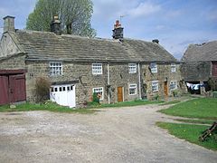
Ughill is a small, rural hamlet within the City of Sheffield in Bradfield Parish in England. It is 5 mi west-northwest of the city centre. It stands in a lofty position at 918 ft above sea level, on a ridge between Bradfield Dale and the valley of the Ughill Brook. It has traditionally been a farming community, but there was some mining in the area in the late 19th and 20th century. Ughill Hall was the scene of an infamous murder in September 1986. The hamlet falls within the Stannington ward of the City.

References

  1. Eastwood, Jonathan (1862). History of the parish of Ecclesfield: in the county of York. Bell and Daldy. p. 124.
  2. Hey, David; Redmonds, George (2002), Yorkshire Surnames and the Hearth Tax Returns Of 1672–73, Borthwick Publications, Introduction, pp.1–2, ISBN   9781904497011
  3. Ordnance survey. 1:2500. c. 2012
  4. 1 2 "Bradfield Dungworth School – About Us", www.bradfielddungworth.sheffield.sch.uk, archived from the original on 15 February 2010, retrieved 10 September 2012
  5. 1 2 "Royal Hotel", www.royalhotel-dungworth.co.uk, retrieved 10 September 2012
  6. Castle, Joe, A Look At Life In Bradfield Dale And The Surrounding Area, Northend Publishing, ISBN   0901100811
  7. "The unique carol singing traditions of the UK". BBC News – magazine. 21 December 2009. Retrieved 3 November 2013.
  8. Merryclough, James (1 November 2023). "A Beginner's Guide to the Sheffield Carols". Tradfolk. Archived from the original on 21 March 2023. Retrieved 8 December 2023.
  9. Watkiss, Allan (8 December 2023). "Sheffield Pub closure could end 200-year Christmas tradition". BBC News. Archived from the original on 8 December 2023. Retrieved 8 December 2023.
  10. 1 2 3 4 5 6 Nunn, Malcolm, Around Bradfield, Loxley and Hillsborough, Chalford Publishing, ISBN   075240671X
  11. Sharpe, N. T. (2002), Crosses of the Peak District, Landmark, p. 43, ISBN   9781843060192
  12. Historic England. "Dungworth Cross (312707)". Research records (formerly PastScape). Retrieved 1 November 2013.
  13. Historic England. "Barn at Briers House Farm Approximately 15 Metres to East of House, Bradfield (1132869)". National Heritage List for England . Retrieved 1 November 2013.
  14. Sources:
  15. Historic England. "Sykehouse with attached outbuildings (1281549)". National Heritage List for England . Retrieved 6 December 2012.
  16. Sources:
  17. Historic England. "Green Fold Farmhouse (1191784)". National Heritage List for England . Retrieved 6 December 2012.
  18. Historic England. "Padley Cottages Padley Farmhouse (1132875)". National Heritage List for England . Retrieved 6 December 2012.
  19. Historic England. "Monument No. 1505402". Research records (formerly PastScape). Retrieved 1 November 2013.
  20. Ordnance Survey. 1:2500. 1923, 1934
  21. Ordnance Survey. 1:2500. 1958–63
  22. South & West Yorkshire Federations of Women's Institutes, "Dungworth & Storrs", The South & West Yorkshire Village Book, Countryside Books
  23. Ordnance Survey, 1:25,000, c. 2010
  24. Ordnance Survey. 1:10560; 1854–5
  25. 1 2 Ordnance Survey, 1:2500; 1891–3, 1903, 1923
  26. 1 2 3 Battye, Ray, The Forgotten Mines of Sheffield, ALD Design and Print, ISBN   1-901-587-40-1 , gives details of mining.
  27. Ordnance Survey. 1:10560; 1955–6. 1:2500; 1963. 1:10000; 1980
  28. Ordnance Survey, 1:25000, c. 2010
  29. "Loadbrook Cottages", www.loadbrook.co.uk, details of Loadbrook Cottage.
  30. Loadbrook House – Loadbrook near Sheffield, Peak District & Derbyshire Dales, Sykes Holiday Cottages, details of Loadbrook House.
  31. "Loadbrook Farm Bed & Breakfast", www.loadbrookfarm.com, details of Loadbrook Farm.