
The River Don is a river in South Yorkshire and the East Riding of Yorkshire, England. It rises in the Pennines, west of Dunford Bridge, and flows for 69 miles (111 km) eastwards, through the Don Valley, via Penistone, Sheffield, Rotherham, Mexborough, Conisbrough, Doncaster and Stainforth. It originally joined the Trent, but was re-engineered by Cornelius Vermuyden as the Dutch River in the 1620s, and now joins the River Ouse at Goole. Don Valley is a UK parliamentary constituency near the Doncaster stretch of the river.

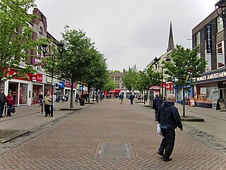
Mexborough is a town in the City of Doncaster in South Yorkshire, England. Situated between Manvers and Denaby Main, it lies on the River Don close to where it joins the River Dearne, and the A6023 road runs through the town. It is contiguous with the town of Swinton which is directly to the southwest immediately across the railway and Conisbrough to the east.

Burngreave ward—which includes the districts of Burngreave, Fir Vale, Grimesthorpe, Pitsmoor, and Shirecliffe—is one of the 28 electoral wards in City of Sheffield, England. It is located in the northern part of the city and covers an area of 2.8 square miles. The population of this ward in 2011 was 27,481 people in 9,906 households. It is one of the wards that make up the Sheffield, Brightside and Hillsborough constituency. Most of the ward is served by a free community newspaper, the Burngreave Messenger.
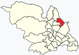
Shiregreen and Brightside ward—which includes the districts of Brightside, Shiregreen, and Wincobank—is one of the 28 electoral wards in City of Sheffield, England. It is located in the northern part of the city and covers an area of 6.5 km2. The population of this ward in 2011 was 20,826 people in 8,696 households. It is one of the wards making up the Sheffield Brightside parliamentary constituency.
The Sheffield and Rotherham Railway was a railway line in England, between the named places. The North Midland Railway was being promoted but its route was planned to go through Rotherham and by-pass Sheffield, so the S&RR was built as a connecting line. It opened in 1838. In Sheffield it opened a terminal station at Wicker, and in Rotherham at Westgate. When the NMR opened in 1840 a connecting curve was made between the two routes.

Swinton is a town in the Metropolitan Borough of Rotherham, in South Yorkshire, England on the west bank of the River Don. It has a population of 15,559 (2011). The town is five miles north-northeast of the larger town of Rotherham and directly west-southwest of Mexborough. The original junior and infant school building built in 1852 on Church Street still exists, and is being converted into residential apartments called Fitzwilliam Lodge.
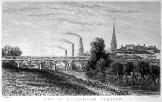
Rotherham Westgate railway station was the eastern terminus of the five-mile-long Sheffield and Rotherham Railway, the first passenger-carrying railway in the Sheffield/Rotherham area. In central Rotherham on the eastern bank of the River Don, it was a single-platform terminus that opened on 31 October 1838 and closed on 4 October 1952.
This timeline of Sheffield history summarises key events in the history of Sheffield, a city in England. The origins of the city can be traced back to the founding of a settlement in a clearing beside the River Sheaf in the second half of the 1st millennium AD. The area had seen human occupation since at least the last ice age, but significant growth in the settlements that are now incorporated into the city did not occur until the industrial revolution.

Transport in Sheffield, England is developed around the city's unusual topography and medieval street plan. Once an isolated town, the transport infrastructure changed dramatically in the 19th and 20th centuries. The city now has road and rail links with the rest of the country, and road, bus and trams for local transport.

Brightside railway station is a former railway station in Sheffield, South Yorkshire, England. The station served the communities of Brightside and Wincobank and was situated on the Midland Main Line on Holywell Road, lying between Attercliffe Road and Holmes railway station.
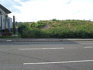
West Tinsley railway station is a former railway station in Sheffield, South Yorkshire, England.
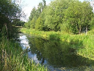
The Greasbrough Canal was a private canal built by the Marquess of Rockingham to serve his coal mining interests in and around the village of Greasbrough, near Rotherham, South Yorkshire, England. It opened in 1780, and the Newbiggin branch was built some time later. The main line to Greasbrough closed in 1840 with the coming of the Sheffield and Rotherham Railway, and the canal ceased to carry commercial traffic during the First World War. Most of it has been filled in, but a small section near the River Don Navigation remains in water.

The River Don Navigation was the result of early efforts to make the River Don in South Yorkshire, England, navigable between Fishlake and Sheffield. The Dutch engineer Cornelius Vermuyden had re-routed the mouth of the river in 1626, to improve drainage, and the new works included provision for navigation, but the scheme did not solve the problem of flooding, and the Dutch River was cut in 1635 to link the new channel to Goole. The first Act of Parliament to improve navigation on the river was obtained in 1726, by a group of Cutlers based in Sheffield; the Corporation of Doncaster obtained an Act in the following year for improvements to the lower river. Locks and lock cuts were built and by 1751 the river was navigable to Tinsley.
Rotherham is a market town in South Yorkshire, England. It is the largest settlement in the Metropolitan Borough of Rotherham. Rotherham is on the banks of both the Rivers Don and Rother, the latter of which the towns name originates.
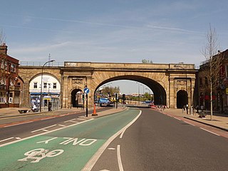
The Wicker is an arterial street in Sheffield, England noted for its history and viaduct that crosses it, the Grade II* listed Wicker Arches. It runs in a north-east to south-westerly direction between Lady's Bridge and the Wicker Arches. For many years the Wicker was an A road, but it has been downgraded following the opening of the Sheffield Northern Relief Road.

Masbrough is a suburb of Rotherham, South Yorkshire, England. It was named as the west of Rotherham by the middle of the Industrial Revolution, namely that part on the left bank of Don. Historically part of the West Riding of Yorkshire, it is in the Metropolitan Borough of Rotherham, centred 0.5 miles (0.8 km) west of Rotherham town centre. Much of the suburb falls within the Rotherham West ward of Rotherham MBC.

Tinsley is a suburb of north-eastern Sheffield, South Yorkshire, England; it falls within the Darnall ward of the city.
Greentop Community Circus Centre is the only circus school in Yorkshire, England, and was established in 1995 on the TV programme Challenge Anneka, and is one of three UK circus schools providing accredited level training courses in circus skills.

St Thomas is a former Anglican church in the Brightside area of Sheffield in England which now serves as a circus training school.

