Gleadless

Last updated

Gleadless
Sheffield outline map with UK.svg
Red pog.svg
Gleadless
Location within Sheffield
Metropolitan borough
Metropolitan county
Region
Country England
Sovereign state United Kingdom
Post town SHEFFIELD
Postcode district S12
Dialling code 0114
Police South Yorkshire
Fire South Yorkshire
Ambulance Yorkshire
UK Parliament
List of places
UK
England
Yorkshire
53°20′45″N1°25′37″W / 53.345773°N 1.426882°W / 53.345773; -1.426882
Gleadless Primary School. Gleadless Primary School.JPG
Gleadless Primary School.
The war memorial on Hollinsend Road. War Memorial, Hollinsend.jpg
The war memorial on Hollinsend Road.
The New Inn on the corner of Gleadless Common and Hollinsend Road. New Inn, Gleadless.jpg
The New Inn on the corner of Gleadless Common and Hollinsend Road.

Gleadless is a suburb and parish [1] within the City of Sheffield, it lies five km (three miles) south east of the city centre. It is bordered by the adjoining suburbs of Gleadless Valley (in whose ward the population falls) to the west, Frecheville to the east and Intake to the north. The land to the south is the rural area of North East Derbyshire district which is outside the city boundary. Gleadless was formerly a country hamlet, then village before becoming part of the expanding city of Sheffield in 1921. The word Gleadless comes from the Old English language and means either "forest clearings haunted by a kite" (gleoda) or "bright clearing" (glaed). [2]

Contents

History

The first written mention of Gleadless dates from 1307 when it was referred to as "Gladeleys in the parish of Handesworth" in a land transaction between Jociamus le Scrop and Henry de Wodetorp. John Speed's map of 1610 calls the area "Gledles" and shows it on the edge of the fenced enclosure called "The Maner". The Maner also known as Sheffield Park was owned by the Duke of Norfolk and had abundant forests upon it. By the end of the 17th century much of the woodland in the park had been cut down with the land being turned over to farming and small scale coal mining. Because of the geology of the district, coal mining would become an important occupation for the area with much of the coal near the surface in shallow seams. A manorial licence shows that coal was dug in the Gleadless area as early as 1579. 18th century agriculture in the area was based on the open field system with common rights on what is today Gleadless Common.

The 1851 census gave Gleadless village a population of only 740, however by 1881 the population had increased to 2,306 with the increased demand for coal drawing many coal miners to the area, especially after the sinking of Birley East Colliery in 1887. The coming of free education in the 1890s saw the opening of, what is today, Gleadless Primary School on 18 April 1898. As with many outlying villages of Sheffield, the coming of the Sheffield Tramway in the early 20th century brought big changes to Gleadless. The south eastern arm of the network reached as far as Intake, just to the north of Gleadless and had a major impact on the end of village life. Employment demographics were changed radically in Gleadless when the last coal was mined at Birley East Colliery in 1943 and many miners moved from the village to work at the Rother Vale Collieries or found alternative employment.

In 1921 Gleadless became part of the City of Sheffield under the Sheffield Extension Order of that year. Changes were not immediate but it became obvious to the local population that something had to be done to try and preserve the rural landscape after the controversial demolition of Park House Farm and the building of the nearby Arbourthorne estate in the 1930s. The Council for the Protection of Rural England became involved in the fight to stop house building on the agricultural land around Gleadless and Norton villages. This had little effect as Gleadless became fully integrated into the city and became surrounded by housing estates. Birley Farm's land became the Frecheville estate, Charnock Hall Farm became the Charnock estate and St. Peter's church and the Base Green estate was built on the site of Base Green Farm. [2]

Present day

Today Gleadless is a suburban community with a population of over 4,000, it is an area of mostly white residents with only a small percentage of ethnic minorities (2.6%). It is an area of above average living standards and low unemployment according to NHS statistics. [3] The suburb has excellent transport links being on the Sheffield Supertram blue and purple routes, there are three tram stops serving the Gleadless area, Hollinsend, Gleadless Townend and White Lane. The tram tracks divide at the Gleadless Townend stop with the main blue route continuing to Halfway while a short spur of the purple route goes to the Herdings Park terminus.

The suburb has four GP practices within half a mile of its centre, these being the White Lane Medical Centre, Stonecroft Medical Centre, Charnock Health Centre and the Jaunty Springs Health Centre. There are three primary schools in the immediate area, these are Gleadless Primary School, Charnock Hall Primary School and Valley Park Community School. Older children attend either Birley Community College or Sheffield Springs Academy. Recreation areas in the suburb include Hollinsend Park, which accommodates the Hollinsend Bowling Club (founded 1932) with two greens. The park was awarded £39,000 in 2012 for the conversion of two old tennis courts into a new multi sport games arena. [4] Jaunty Park is a small recreation area while Gleadless Common has been enlarged in recent years when Myrtle Springs School was closed and some of its grounds were integrated into the common. Four pubs in the area are the Centre Spot on Jaunty Lane, the Hollin Bush and New Inn both on Hollinsend Road, and the Red Lion at Gleadless Townend, the Red Lion has the Shire Brook stream rising as a spring in its cellar.

Significant buildings

Christ Church Christ Church, Hollinsend Road.jpg
Christ Church

Commonside farmhouse is a grade two listed building situated just off Gleadless Common. The building dates from around 1800 and was originally a pair of cottages before being converted into a farmhouse. In recent years the building has undergone a complete renovation including new roof, windows and doors and has been integrated into a new small housing development known as Commonside Croft. [5] Christ Church on Hollinsend Road is also grade II listed, it dates from 1839 and includes a three-stage tower, the interior features a chancel which is used as a meeting room. [6] Christ Church has a daughter church in the area, St Peter's on White Lane serves the Basegreen district of the suburb. Other places of worship in the area are the Gleadless Methodist Church and Gleadless United Reformed Church. The war memorial and its enclosing wall on Hollinsend Road is grade II listed it features a life size sandstone figure of a soldier with a rifle. [7]

Related Research Articles

<span class="mw-page-title-main">The Moss</span> River in England

The Moss is a brook in North East Derbyshire, England.

<span class="mw-page-title-main">Beighton (ward)</span> Electoral ward in the City of Sheffield, South Yorkshire, England

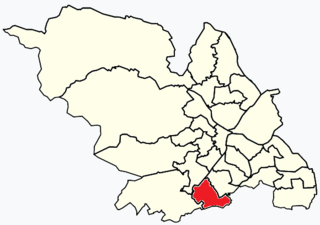
Beighton —which includes the districts of Beighton, Hackenthorpe, Owlthorpe, and Sothall—is one of the 28 electoral wards in City of Sheffield, England. It is located in the eastern part of the city, on the border with Rotherham and covers an area of 5.7 km2. The population of this ward in 2011 was 17,939 people in 7,538 households.

<span class="mw-page-title-main">Rossington</span> Civil parish and former mining village in South Yorkshire, England

Rossington is a civil parish and former mining village in the Metropolitan Borough of Doncaster in South Yorkshire, England and is surrounded by countryside and the market towns of Bawtry and Tickhill.

<span class="mw-page-title-main">Arbourthorne</span> Electoral ward in the City of Sheffield, South Yorkshire, England

<span class="mw-page-title-main">Beauchief and Greenhill</span> Electoral ward in the City of Sheffield, South Yorkshire, England

<span class="mw-page-title-main">Richmond, Sheffield</span> Suburb and electoral ward in the City of Sheffield, South Yorkshire, England

Heeley is a former cluster of Derbyshire villages. Which all now form a suburb in the south of the City of Sheffield, England. The village has existed at least since 1343, its name deriving from Heah Leah, High Lea then Hely, meaning a high, woodland clearing. Originally Heeley was divided into three: Upper Heeley was around the intersection of Myrtle Road and Heeley Green, Middle Heeley was on the Gleadless Road at Well Road, and Lower Heeley was on the London Road around Artisan View. At the 2011 Census the village formed part of the Gleadless Valley ward of the City of Sheffield.

<span class="mw-page-title-main">Hackenthorpe</span> Village in South Yorkshire, England

Hackenthorpe is a village 5 miles south east of Sheffield’s city centre, now classed as a historic township of the city. Due to much expansion, the village became a part of Sheffield city during the 1950s. During much of the late 19th and 20th centuries the village was noted for its steelmaking, with the Thomas Staniforth & Co Sickle works being based at Main Street. Another prominent feature of the village is the 17th century Hackenthorpe Hall, built by John Newbould for the Hounsfield family, with James Hounsfield being a prominent land owner. The building is today used as a nursery.

<span class="mw-page-title-main">Birley</span> Electoral ward in the City of Sheffield, South Yorkshire, England

<span class="mw-page-title-main">Frecheville</span> Village in South Yorkshire, England

Frecheville is a suburb five miles (8.0 km) south-east of Sheffield’s city centre. The estate was built in the 1930s when the area was in Derbyshire. However, due to expansion, Frecheville and a number of surrounding villages became part of the city of Sheffield in 1967 and thus the West Riding of Yorkshire.

<span class="mw-page-title-main">Areas of Sheffield</span>

The areas of Sheffield, a city and metropolitan borough in the north of England, vary widely in size and history. Some of the areas developed from villages or hamlets, that were absorbed into Sheffield as the city grew, and thus their centres are well defined, but the boundaries of many areas are ambiguous. The areas of Sheffield do not play a significant administrative role, but the city is divided into 28 electoral wards for local elections and 6 parliamentary constituencies for national elections.

<span class="mw-page-title-main">Birley Collieries</span> Former collieries in South Yorkshire, England

The Birley Collieries were a group of coal mines set in the Shire Brook Valley in south-east Sheffield, South Yorkshire, England. They were connected to the railway system by a branch line from the Manchester, Sheffield and Lincolnshire Railway at Woodhouse East Junction, about 800 yards east of Woodhouse station.

The Sheffield Coal Company was a colliery owning and coal selling company with its head office situated in South Street, Sheffield, South Yorkshire, England.

<span class="mw-page-title-main">Sheffield Outer Ring Road</span>

<span class="mw-page-title-main">Intake, Sheffield</span> Village in South Yorkshire, England

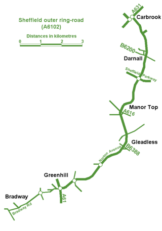
Intake is a suburb and former village located 5 miles (8 km) south-east of Sheffield city centre, South Yorkshire, England. Due to expansion during the 20th century, the village became a part of the city of Sheffield. Intake is linked to Frecheville via Birley Moor Road, and to Gleadless via Hollinsend Road.

<span class="mw-page-title-main">Shire Brook</span> Waterway in South Yorkshire, England

Shire Brook is a small stream in the south eastern part of the City of Sheffield in South Yorkshire, England. It rises in the suburb of Gleadless Townend and flows in a general easterly direction for 4 miles (6.5 km) to its confluence with the River Rother between Beighton and Woodhouse Mill. In the past the brook has been both the border of Yorkshire and Derbyshire and between the sees of Canterbury and York. The course of the stream has been influenced by human intervention in the 20th century with the brook being diverted underground and flowing through culverts on three occasions as it traverses locations which were formerly landfill sites and extensive railway sidings.

Gleadless Valley is a housing estate and electoral ward of the City of Sheffield in England. The population of the ward at the 2011 Census was 21,089. It lies 2.5 miles (4.0 km) south-southeast of the city centre. Formerly a rural area, Gleadless Valley was developed as a large housing project with around 4000 dwellings by Sheffield City Council between 1955 and 1962. It is an area of undulating land drained by the Meers Brook, which has its source on the high ground in the woodland at Gleadless. Adjacent are Gleadless to the east, Norton to the south-west, Heeley to the west and Arbourthorne to the north.

The S12 district lies within the City of Sheffield, South Yorkshire, England. The district contains 13 listed buildings that are recorded in the National Heritage List for England. All the listed buildings are designated at Grade II, the lowest of the three grades, which is applied to "buildings of national importance and special interest". The district is in the south east of the city of Sheffield, and covers the areas of Birley, Charnock, Gleadless, Gleadless Townend, Frecheville, Hackenthorpe and Intake.

<span class="mw-page-title-main">Fulwood, Sheffield</span> Suburb of Sheffield in South Yorkshire, England

Fulwood is a residential suburb and ward of the City of Sheffield in England, it lies 5.5 km west-southwest of the city centre. Formerly an ancient settlement and village on the Porter Brook, it became integrated into the city in the 1930s. It is bounded by the suburbs of Lodge Moor to the NW, Ranmoor to the east and Crosspool to the NE. The open countryside of the Peak District lies to the west and SW. The sub districts of Stumperlowe and Goole Green are part of the suburb. The population of the ward at the 2011 Census was 18,233. Fulwood is located in the Sheffield Hallam constituency which, as of the 2019 general election voted Labour.

References

  1. A Church Near You. Parish Map.
  2. 1 2 "Gleadless: From Village To Suburb", Pauline Shearstone, Self published, ISBN   0 9510362 0 3, Gives history and name meaning.
  3. Gleadless Neighbourhood Profile. Archived 2012-09-15 at the UK Government Web Archive Gives statistics.
  4. Veolia Trust. Gives details of grant to Hollinsend Park.
  5. Historic England. "Commonside farmhouse and adjoining farm buildings (1270565)". National Heritage List for England . Retrieved 7 October 2012.
  6. Historic England. "Christ Church (1255147)". National Heritage List for England . Retrieved 7 October 2012.
  7. British Listed Buildings. Gives details of War Memorial, Hollinsend Road.