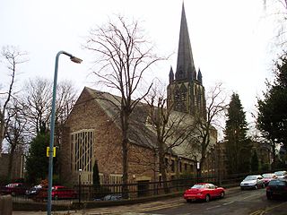
Church of St Mark is a Church of England parish church in the Sheffield suburb of Broomhill, in England.

Broomhill and Sharrow Vale — which includes the districts of Broomhill, Broomhall, Crookesmoor, Endcliffe, Sharrow Vale and Tapton Hill — is one of the 28 electoral wards in City of Sheffield, England. The ward was created following the 2015 local government boundary review out of parts of the old Broomhill, Central and Nether Edge wards. It is located in the western part of the city. The population of the Broomhill ward in 2011 was 16,966 people in 5,708 households, covering an area of 2.7 km2. Broomhill & Sharrow Vale is one of the wards that make up the Sheffield Central Parliamentary Constituency.
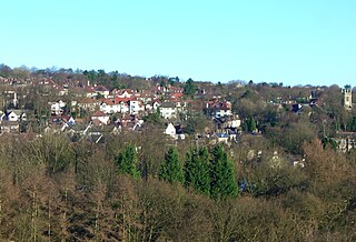
Crosspool is a suburb of the City of Sheffield, South Yorkshire, England, located 2.5 miles (4 km) west of the city centre. The suburb falls within the Crookes ward of the City of Sheffield. It is a middle class residential area in an elevated position above the Porter and Rivelin valleys and stands at around 660 feet (200 m) above sea level. Crosspool is situated on the A57 road and is the last suburb on that road before the city boundary and open countryside is reached. In 2011 Crosspool had a population of 6,703.

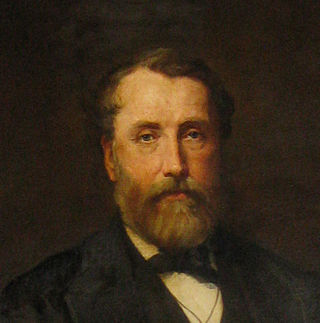
Sir John Brown, English industrialist, was born in Sheffield. He was known as the Father of the South Yorkshire Iron Trade.
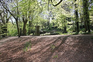
The General Cemetery in the City of Sheffield, England opened in 1836 and closed for burial in 1978. It was the principal cemetery in Victorian Sheffield with over 87,000 burials. Today it is a listed Landscape on the English Heritage National Register of Historic Parks and Gardens. It is also a Local Nature Reserve. It is owned by the City of Sheffield and managed on behalf of the city by a local community group, the Sheffield General Cemetery Trust.

Whirlow is a suburb of the City of Sheffield in England, it lies 3.7 miles (6 km) south-west of the city centre. The suburb falls within the Dore and Totley ward of the City. It is one of the most affluent areas of Sheffield, with much high class housing and several notable small country houses within it. During the Victorian era it was home to some of Sheffield's most influential citizens. Whirlow straddles the A625, the main Sheffield to Hathersage road. The suburb covers the area from Parkhead in the north to Whirlow Bridge in the south and from Ecclesall Woods in the east to Broad Elms Lane in the west. Whirlow had a population of 1,663 in 2011.

The Sir Frederick Mappin Building, or more familiarly the Mappin Building, is a Grade II listed building fronting onto Mappin Street, Sheffield, England, part of the University of Sheffield. The building and street are named after Sir Frederick Mappin (1821–1910), the so-called Father of Sheffield University.

St John's Church, Ranmoor is a large parish church in Ranmoor, a suburb of the City of Sheffield, England. It is a Church of England church in the Diocese of Sheffield, and it is the second church to be built on this site after the original church was destroyed by fire in 1887. It has a 190-foot-tall (58 m) tower and spire, the second tallest church spire in Sheffield after the Cathedral Church of St Marie which is just 5 ft taller.

Notre Dame Catholic High School in Sheffield, South Yorkshire, England, was established in the 1850s by the Sisters of Notre Dame, a religious order. It was, for many decades, a fee paying school. It currently has 1400 students, with a 1:17.3 Teacher: Student ratio.
Mark Firth was an English industrialist and philanthropist.

Sheffield Old Town Hall is a building in Waingate in central Sheffield, South Yorkshire, England, opposite Castle Market. It is a Grade II listed building.
Ranmoor/Endcliffe is a development of student accommodation for the University of Sheffield, located in Endcliffe in west Sheffield between Fulwood Road, Endcliffe Vale Road and Westbourne Road. The village accommodates most of the university's first-year undergraduates, alongside some second- and third-years, postgraduates and student families.

Endcliffe Hall is a 19th-century, 36-room mansion situated on Endcliffe Vale Road in the City of Sheffield in the suburb of Endcliffe. The hall is situated just over 2 miles (3.2 km) west of the city centre and is a Grade II* Listed building.

The Mount is a Grade II* listed building situated on Glossop Road in the Broomhill area of Sheffield in England. It stands just over 1.3 miles (2.1 km) west of the city centre. It is a neoclassical building which was originally a terrace of eight houses but since the 1950s has been used for commercial office space for various businesses. The building is part of the Broomhill Conservation Area, which was set up in March 1977 through an agreement with local residents and Sheffield City Council.

Norton Hall is an English country house situated on Norton Church Road in the suburb of Norton in Sheffield, England. For most of its history it has been a private residence, in its latter history it has been used as a NHS hospital, a private hospital and has now been converted into high quality apartments. It is a Grade II* listed building.
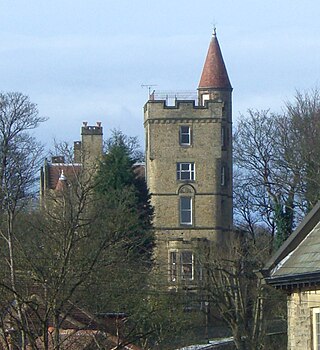
The Towers is a small English country house situated in Sheffield, England. The house stands on Sandygate Road close to the junction with Coldwell Lane in the suburb of Crosspool. It is a Grade II listed building as is the lodge and attached gateway and the concave garden wall. It has been described as “an extraordinary Scottish baronial fantasy”.

Firth Park is a public park in the Firth Park area of the City of Sheffield in England. It is located 2.33 miles (3.75 km) north-northeast of the city centre. The main entrance to the park is on Hucklow Road although there are several entrances on Firth Park Road to the east and one on Vivian Road to the south. Established in 1875, the park gave its name to the Sheffield suburb of Firth Park, a social housing estate constructed around the area of the park in the 1920s and 1930s.
Fulwood is a residential suburb and ward of the City of Sheffield in England, it lies 5.5 km west-southwest of the city centre. Formerly an ancient settlement and village on the Porter Brook, it became integrated into the city in the 1930s. It is bounded by the suburbs of Lodge Moor to the NW, Ranmoor to the east and Crosspool to the NE. The open countryside of the Peak District lies to the west and SW. The sub districts of Stumperlowe and Goole Green are part of the suburb. The population of the ward at the 2011 Census was 18,233. Fulwood is located in the Sheffield Hallam constituency which, as of the 2019 general election voted Labour.

John Dodsley Webster FRIBA (1840–1913) was an English architect who designed more than 15 churches in Sheffield in various Gothic styles, usually working to a tight budget. His work also included hospitals and commercial buildings, small country houses and private houses. All his known work was carried out in the South Yorkshire and North Derbyshire area except for a chapel and school built in Coventry.

The Porter Valley Parks are a series of public parks and green spaces in Sheffield, England. Lying along the valley of Porter Brook, they run radially out from the city centre, providing a direct green-space connection to the Peak District national park. Created variously between 1855 and 1938, they comprise in order from the city centre; Endcliffe Park, Bingham Park, Whiteley Woods, Forge Dam Park and Porter Clough.


