
Stocksbridge is a town and civil parish, in the City of Sheffield, in South Yorkshire, England. The town is approximately 9 miles (14 km) from Barnsley and 10 miles (16 km) from Sheffield.

Bradfield is a civil parish in the City of Sheffield, in South Yorkshire, England.

The areas of Sheffield, a city and metropolitan borough in the north of England, vary widely in size and history. Some of the areas developed from villages or hamlets, that were absorbed into Sheffield as the city grew, and thus their centres are well defined, but the boundaries of many areas are ambiguous. The areas of Sheffield do not play a significant administrative role, but the city is divided into 28 electoral wards for local elections and 6 parliamentary constituencies for national elections.

Stocksbridge and Upper Don ward is one of the 28 electoral wards of the borough of Sheffield, South Yorkshire, England. The population of this ward was 18,541 at the 2011 Census.

Deepcar is a village located on the eastern fringe of the town of Stocksbridge, South Yorkshire, England. It is in the electoral ward of Stocksbridge and Upper Don, 10 miles south-west of Barnsley town centre and 9.5 miles (15.3 km) approximately north-west of Sheffield city centre.

Oughtibridge is a residential village in the north of Sheffield within the bounds of Bradfield civil parish. The village stands about 5 miles (8 km) northwest of the city centre in the valley of the River Don.

The Little Don River also known as the Porter, is a tributary of the River Don in South Yorkshire, England. Arising on the Langsett Moors in the northern Peak District, the Little Don River feeds the Langsett and Underbank Reservoirs. It runs through the town of Stocksbridge before joining the River Don.

Penistone and Stocksbridge is a constituency in South Yorkshire represented in the House of Commons of the UK Parliament since 2024 by Marie Tidball, a Labour MP. As with all Westminster constituencies, adults qualifying to vote in the seat elect one Member of Parliament (MP) by the first past the post system at least every five years.
Sheffield is a geographically diverse city in England. It nestles in the eastern foothills of the Pennines and the confluence of five rivers: Don, Sheaf, Rivelin, Loxley and Porter. As such, much of the city is built on hillsides, with views into the city centre or out to the countryside. The city is roughly one third urban, one third rural and one third in the Peak District. At its lowest point the city stands just 29 metres above sea level at Blackburn Meadows on the Rotherham border, rising up to over 500 m in some parts of the city to a peak of 548m at High Stones on the Derbyshire border; however, 89% of the housing in the city is between 100 and 200 metres above sea level. Over 95% of the population resides in the main urban area.

Thurgoland is a village and civil parish in the Metropolitan Borough of Barnsley in South Yorkshire, England, on the A629 road. According to the 2001 census the parish had a population of 1,801, increasing to 1,969 at the 2011 Census.

High Green is a village located about 6 miles from Barnsley, the nearest major town. It is found to the north of Chapeltown and is served by buses; the nearest rail station is in Chapeltown 1 mile away. The suburb falls within the West Ecclesfield ward of the city Council. Wharncliffe Crags are nearby, as is Westwood Country Park.
Middlewood is a north western suburb of Sheffield, South Yorkshire, England. The suburb falls within the Stannington ward of the City.
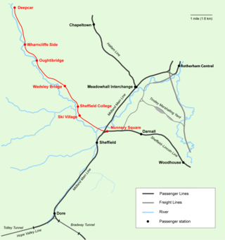
Don Valley Railway first formed as a heritage rail project in September 2003 to operate on the freight rail line between Stocksbridge Steel Works and Sheffield following the route of the former Woodhead Line between Deepcar and Sheffield, The project is developed by Don Valley Railway Ltd., a not-for-profit company and registered charity based in Stocksbridge, South Yorkshire. Original plans to operate heritage rail services for the dual purpose of providing infrastructure for tourism over the weekends, alongside regular commuter services have now shifted towards concentrating on the development of a viable commuter service - though with help of outside assistance heritage plans could be revised. In 2023, the Department for Transport announced that the Don Valley Line will be restored for passenger use.

The Stocksbridge Railway was a subsidiary of Samuel Fox and Company and linked the company's works at Stocksbridge, near Sheffield, South Yorkshire, England, with the main line of the Manchester, Sheffield and Lincolnshire Railway at Deepcar. As the size of Fox's steelworks expanded, better transport links were needed, and the railway was authorised by an Act of Parliament in 1874. It was completed in 1877, and remained an independent subsidiary until 1992, when it became part of the steelworks operation. When the Woodhead line was closed to the north of Deepcar, the line south to Sheffield was singled, and operates as a long siding.
Bolsterstone is a village in South Yorkshire, England, south of Stocksbridge, and 8.5 miles to the northwest of the City of Sheffield and within the city borough. It lies on the border of the Peak District national park. Bolsterstone had a population of 386 in 2011.

Wharncliffe Crags is a gritstone escarpment or edge situated approximately 6 miles (10 km) north-west of the city of Sheffield in South Yorkshire, England. It is a geological Site of Special Scientific Interest.

Midhopestones is a village in the civil parish of Bradfield within the Stocksbridge and Upper Don electoral ward in the borough of the City of Sheffield, England.

Ewden Valley is a valley in the civil parish of Bradfield in the Stocksbridge and Upper Don electoral ward of Sheffield, South Yorkshire, England.

The Upper Don Trail formerly known as the Upper Don Walk is a 15 mile long recreational multi use trail which links the centre of Sheffield to the village of Oughtibridge. Various sections continue along the course of the upper Don to Dunford Bridge and along the Little Don from Deepcar out towards Stocksbridge and Langsett Reservoir. It follows the course of the River Don and partially the National Cycle Network route 627. Beyond Wortley the Trail forms part of the Trans Pennine Trail. The route is variable in quality, the first mile is well defined as it has been integrated into the newly developed quarters to the immediate north of the city centre. The section through Beeley Woods between Wadsley Bridge and Oughtibridge is heavily used by walkers and cyclists. The rest of the route is a mixture of path, road and woodland walking.
Midhopestones is a village which forms part of the parish of Bradfield, in the City of Sheffield, South Yorkshire, England; here defined as the part of the parish in the Stocksbridge and Upper Don ward and the S36 postcode area. The area contains 23 listed buildings that are recorded in the National Heritage List for England. Of these, one is listed at Grade II*, the middle of the three grades, and the others are at Grade II, the lowest grade. The area is to the northwest of the city of Sheffield, and contains the village of Midhopestones, the hamlets of Upper Midhope and Wigtwizzle, and a large area of countryside, much of which is moorland.

